Utilization of natural pastures in Huascarán National Park by local Andean ‘pasture users’ and ‘campesino communities’
28.02.2012
-
SUBMITTED ORGANISATION :
-
Huascaran National Park, National Service of Protected Natural Areas (Servicio Nacional de Areas Naturales Protegidas por el Estado: SERNANP)
-
DATE OF SUBMISSION :
-
28/02/2012
-
REGION :
-
South America
-
COUNTRY :
-
Peru (Ancash)
-
SUMMARY :
-
The Cordillera Blanca is one of the most spectacular mountain landscapes in Peru, famous for a variety of high peaks over 6,000masl and its numerous glaciers. It is also an area with a very long history of human occupation and usufruct of natural pastures by ‘campesino’ (or peasant farmer) communities. In fact, their occupation of the area has contributed to the shaping of the current landscapes as a blend of natural and long-term cultural features and processes. The resultant landscapes support a wide diversity of ecosystems and plant communities that are home to important populations of plant and animal species, some of them endemic to Peru, many of them threatened with extinction. The area has attracted mountaineers and steadily increasing numbers of other tourists for many decades, and in 1975, the national importance of the area was officially recognized by the government of Peru, with the formal creation of Huascarán National Park and a surrounding buffer zone, encompassing about 95% of the cordillera. The international importance of the area was also recognized in 1977 with its proclamation as the core area for a Biosphere Reserve under the United Nation’s Man and the Biosphere Program. When Huascarán National Park was established in 1975, the “posesión de usufructo de pastos antes de 1975” (possession of usufructary rights to graze prior to 1975) was recognised as a pre-existing, and therefore continuing, right. This has been formalised in national legislation and is reflected in the Master Plans for the management of the park through the designation of “special use zones” that include the natural pasture areas. However, many of these natural pastures are now in poor to very poor condition due to sustained high grazing pressures from the livestock of the population surrounding the park. And, added to this, the effects of climate change have worsened the condition of these ecosystems (‘puna’ grasslands; ‘bofedales’ wetlands) and these effects are predicted to gradually worsen. For the local communities to continue to use (usufruct) these natural pastures of Huascarán National Park sustainably, and especially in the face of increasing climate change effects, it will be necessary to develop and implement more efficient and effective management practices. There are currently projects in place to improve the condition of the park’s natural pasture areas and these are being implemented through a range of community participation and awareness raising activities.
-
AUTHOR:
-
Marco Arenas Aspilcueta, Responsable de la Unidad Operativa Funcional de Gestión Participativa, Direccion de Gestion de las Areas Naturales Protegidas – SERNANP
Huascarán National Park
Huascarán National Park is situated in the central western región of Peru, within the Department of Ancash (see Figure 1 below). It was established on July 1, 1975, by Supreme Decree N ° 0622-75-AG. It is a Natural Protected Area of 340,000 ha, established for the conservation of animals and plants within their unique and varied natural ecosystems that are maintained to allow for their continued evolution and adaptation in the face of climatic and other external agents that may affect them.
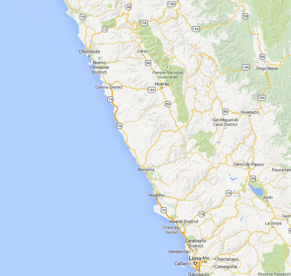
Figure 1. Location of Huascarán National Park, Ancash, Peru
As with other natural protected areas in Peru, the national park is surrounded by a buffer zone (Zona Amortiguimiento). This covers 170,200 ha. The National Park is also the core conservation zone of Huascarán Biosphere Reserve proclaimed under UNESCO’s “Man and the Biosphere” program in March 1977. This biosphere reserve extends the national park and its buffer zone through an additional transition zone of a further 645,600 ha. See figure 2 (below) for boundaries of each of the biosphere reserve zones: national park (green); buffer zone (yellow); transition zone (edge of map). In 1985, further international recognition was conferred on the park by UNESCO through designation as a World Heritage Site.
The national park is located in the Cordillera Blanca, the highest tropical mountain range in the world, that has 30 ice-covered peaks over 6,000masl which, at the time of proclamation, supported 712 glaciers, 434 lakes and 41 rivers (e.g. see Figures 3, 4, 6 and 8 below). The park is also recognised, through a program of Birdlife International, as an Important Bird Area (IBA) for the conservation of its endemic bird species whose populations are under threat. Three other IBAs occur within the Huascarán Biosphere Reserve.
The park also contributes to the socio-economic development of the surrounding human populations, with 5 human settlements totalling 548 people (in 2010) occurring within the park and a further 83,047 people living in the surrounding buffer zone. This support for local socio-economic development takes the form of a diversity of ecosystem services for a multitude of beneficiaries
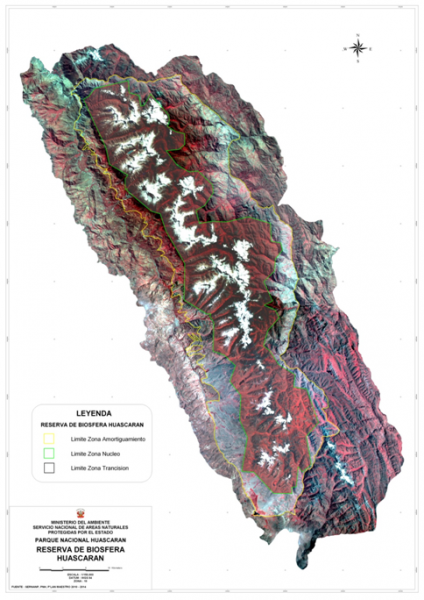
Figure 2. Satellite view of Huascaran Biosphere Reserve showing its National Park (nucleus or core zone), its buffer zone and its transition zone
(summarized in Cuadro No 28 of the Master Plan for Huascarán National Park, SERNANP (2011)). These range from water supply (storage, and the regulation of quality, quantity and seasonality of flow), to tourism (including alpine and mountain expeditions, and other outdoor and nature-based activities) and supplies of other natural resources such as medicinal and wild food plants for human use, and pastures for livestock grazing.
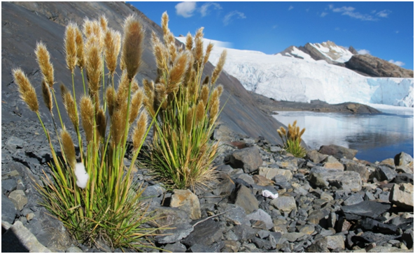
Figure 3. Photograph of the Cordillera Blanca within Huascarán National Park
The stated reasons for creating the national park include that:
- it possesses a great wealth of flora and fauna species, of geological formations, of snow and ice-covered mountain peaks, and is of great scenic beauty
- the varied ecosystems of the Cordillera Blanca should be conserved by the State because of the national natural, scientific and cultural heritage values they support
- the Cordillera Blanca contains archaeological monuments that give testament to the impressive history of Peru
- the establishment of the national park in the zones specified would permit tourism activities to be developed that could directly return socio-economic benefits to the local population*.
(*In 2013, for example, a total of 4,914 visitors were recorded for Quebrada Quillcayhuanca, one of the heavily-grazed valleys within the national park and closest to the city of Huaraz. This total consisted of 1,465 Peruvian nationals and 3,449 foreigners.)
Usufruct of Natural Pastures in Huascarán National Park
When Huascarán National Park was established in 1975, the “posesión de usufructo de pastos antes de 1975” (possession of usufruct rights to graze prior to 1975) was recognised in the Supreme Decree (0622-75-AG). This was reinforced in the year 1980 through the issuing of Ministerial Resolution No. 01200-80-AA-DGFF, with the purpose of rationalising the use of existing natural pastures in the quebradas of Huascarán National Park, in order to achieve conservation of wildlife resources. This has since been reflected in the Master Plan for the management of the park through the designation of “special use zones” that include the natural pasture areas within the park (SERNANP 2011). These areas are primarily located in the relatively flat floors of the steep-sided ‘quebradas’ (valleys) issuing from the high mountains where their vegetation type is primarily classified as ‘pajonal / cesped de puna’ (grasslands). Special Use Zones are defined as:
“Spaces occupied by human settlements that pre-date the establishment of the natural protected area, or in which by special situations, there is a type of agricultural use, livestock, agrosilvopastoral or other activities that involve the transformation of the original ecosystem.” Ley de Areas Naturales Protegidas. Art. 23, Ley 26834 – 1997.
Livestock grazing of these natural pastures provides sources of food and income for local campesino communities, and has been a key aspect of traditional culture there for many centuries. While such grazing was originally based on natural (and domesticated native) soft-footed, camelid species (vicuña, llama, alpacas) this changed quickly after Spanish colonisation to hard-hooved cattle and sheep, as well as horses and donkeys. This latter combination has continued to the present time with relatively few camelids grazed within the park today.
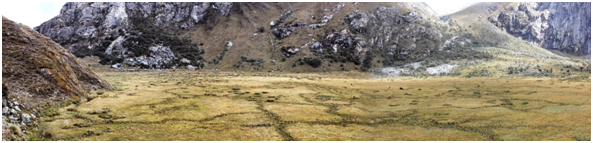
Figure 4. (a) Bofedales areas within a quebrada of Huascarán National Park
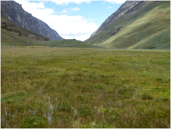
Figure 4. (b) Bofedales areas within a quebrada of Huascarán National Park
More than 4.5% of the area of the national park is covered by natural pastures (i.e about 15,300 hectares). These areas encompass both aquatic and semi-aquatic communities – including bofedales wetlands – and all are bordered by areas of shrubby matorral, high altitude forests of Polylepis, and/or lithophytic communities. Bofedales wetlands (see Figs. 4 a & b above) constitute approximately 4.4% of the grasslands of HNP (equivalent to about 675 hectares, or 0.2% of the park) and, because of their postion in the landscape, their vegetation compostion and form, and their soil structure and depth, they are critical parts of the water cycle of these mountain catchments and contribute significantly to the generation of ecosystem services.
These services include the accumulation (temporary storage) and filtration of water that is vital for agricultural and other uses further down the catchment. They are therefore critical in the maintenance of both the quality and quantity of water supplies and of the maintenance of year-round flows. They are also very important for the storage of carbon, and recent research has demonstrated the potential of bofedales (oconales) wetlands in the capture and fixation of metals, therefore also regulating further, the quality of the water.
Locally, these services also include the provision of foods and hábitats for wildlife, and feed and water for livestock. Unfortunately, some bofedales wetland areas are also being drained, to dry them out sufficiently to make them accessible to the stock that otherwise attempt to avoid boggy ground due to the risk of becoming stuck in the mud (see Fig. 5).
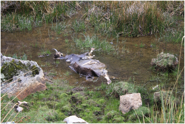
Figure 5. Trampled margins of a drainage line within an area of bofedales wetlands with the carcass of a bogged cow.
The bofedales areas are then being trampled and much of their vegetation eaten. This issue has significant implications for water flows both within the ‘quebradas’ and further down the catchment. It also has implications for carbon storage, or for carbon liberation to the atmosphere.
Over-grazing has reduced vegetative cover (see Fig. 6), compacted soils, significantly interrupted the life-cycles of many plant species including the prevention of seed-set and, as a consequence, has limited the rates of genetic exchange within many plant populations. The hard hooves of the livestock also contribute to significant levels of erosion due to vegetation damage, and to the compaction and channelling of the soil surface, which can lead to stream-bank erosion. The faeces from the high numbers of animals also affect soil and water nutrient levels.
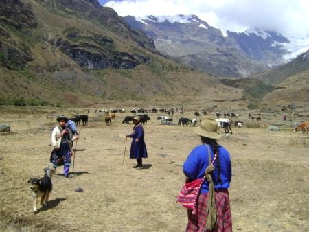
Figure 6. Cattle grazing within a quebrada of Huascarán National Park
Substantial areas of the natural pastures are now in poor to very poor condition due to sustained high grazing pressures from the local livestock – primarily cattle, sheep and horses (Palomino 2009). The master plan for the park, summarises the general scale of grazing presssures for 41 ‘quebradas’ (SERNANP 2011; see cuadro No. 15), indicating that many tens of thousands of livestock are being grazed within the special use zones. In some areas, the grazing pressure is estimated to be almost five times the sustainable carrying capacity (recent, but unpublished, data). In addition, the affects of climate change are already taking their toll with, for example, at least a 30% decline in the area of glaciers recorded within the park between 1970 – 2003 (SERNANP 2011).
Added to these problems, the introduction of exotic species also needs to be considered. For example, kikuyu grass (Pennisetum clandestinum) is gradually spreading within the quebradas of the park and is displacing native plant species. Also, the presence of domestic cattle and sheep throughout much of the park for several centuries has introduced and sustained populations of internal and external parasites which can cause debilitating disease in camelids, the preferred grazing species for the park from a conservation perspective. These parasites include common liver fluke (Fasciola hepática) in sheep and cattle, and beef tapeworm (Taenia saginaria) in cattle, plus the skin parasite Sarcoptes scabiei, which can cause outbreaks of sarcoptic mange. All contribute to the generally poor condition of most of the livestock present.
For the local communities to exploit these natural pastures in a sustainable way, especially in the face of increasing climate change effects (Plan Maestro, SERNANP 2011), it will be necessary to develop and implement more efficient and effective management practices for each of the different resources within the productive parts of the system (i.e. soil, water, vegetation and animal carrying capacities). This will require significant changes in community attitudes and expectations by both the peasant farmer communities and by the wider community throughout the surrounding regións.
To work towards such changes it is necessary to understand the current cultural, social and legal setting in which the issues arise.
Andean peasant farmer communities
Socio-Cultural and Legal Setting.
The culture of local Andean peasant farmer communities (comunidades campesinas) is deeply-rooted in the traditions of family and community responsibilities for obtaining and maintaining livelihoods – food, clothing and shelter – frequently under harsh environmental conditions. This strength of dependence on family and community has been reinforced frequently over the centuries through the social and economic influences from, as well as the challenges and hardships enforced by, a wide variety of different governing States. These have ranged from the Chavín Culture (900 – 200 BC), Wari Empire (600 – 1100 AD) and Inca Empire (1438 – 1572) periods of influence, through the Spanish colonial (1533-1821) and then post-colonial governance periods, to current circumstances that were initiated with the agrarian reforms of the 1970s (Villanueva 2009). These latter reforms, among other things, led to the return of lands of the post-colonial large estates to their former traditional occupant communities.
The common cultural foundation through these times was the ‘ayllu’ – a traditional indigenous local government model in the Andes, especially among Quechuas and Aymaras. It consisted of a network of families in a given area with a focus on self-sufficiency on commonly held territory, supported by arrangements of expected reciprocity, and where members engaged in shared collective labor and in reciprocal exchanges of assistance (for more details see Satoyama Case Study titled: “The Ayllu System of the Potato Park, Cusco, Peru”; https://satoyama-initiative.org/old; versión dated 03/05/2010).
Similar community structures and functions still exist today, but now come under the formal title of comunidades campesinas (peasant farmer communities). This is a legally-recognised name under both the Political Constitution of Peru and under specific law. The Political Constitution of the State (of Peru) (El Congreso Constituyente Democrático del Peru, 1993) succinctly recognizes (in article 89 of part III of chapter IV) that, comunidades campesinas y nativas, ‘have legal existence and are legal“persons”’ in the eyes of the law, that ‘the property of their lands is durable / ongoing…’ and that ‘the State respects the cultural identity…’ of these communities.
This recognition was originally formalised in the Peruvian General Law of ‘Comunidades Campesinas’; Law No. 24656 of 13 April 1987; in which the State:
(a) guarantees the integrity of the right of ownership of the “common” lands of the peasant farmer communities;
(b) respects and protects the community work as a form of participation of the community members to establish and preserve the goods and services of communal interest, regulated by an indigenous customary law;
(c) promotes the organization and operation of community, multi-community and other associative forms of business freely constituted by the community; and,
(d) respects and protects the usages, customs and traditions of the community.
This law also provides legal definitions of such communities and their membership, and a framework for governance and decisión-making, through a General Assembly for each community.
Use of communal pastures by qualified community members.
With respect to the taking of decisions about grazing of community lands, Artícle 13º of Law No. 24656 states that: “In the case of natural grazing lands, the General Assembly of the community determines the maximum number of livestock owned by each qualified farmer who can graze on those lands, as well as for the establishment of communal production units”. In addition, Artícle 37º of this law states that: “The Public Sector will promote the development of animal husbandry within the ‘campesino’ communities, through the introduction of new technologies in the management of pastures, new varieties of grasses and the improvement of South American camelid, cattle, sheep and other livestock”.
Socio-economic setting.
The grazing of livestock within the national park also needs to be understood in terms of the local socio-economic setting of the families involved. This can be summarised from the results of a Social Survey undertaken in 28 of the 32 districts that have territories within the national park and its buffer zone, that is provided as an Annexe to the master plan for Huascarán National Park (Villaneuva 2009; SERNANP 2011).
The population within the park and its buffer zone at the time of the survey (in 2007) was noted to be 83,047 people, including 50 settlements with 548 inhabitants living within the park boundary. Approximately 74% of the population within the park + buffer zone were classified as rural (‘campesino’), while the remaining 26% were classified as urban dwellers. In the decade after 1997, the total population had dropped by 1.1%, with the urban population increasing by 1.5% and the rural population falling by about 1.8%.
The great majority of people spoke Quechua as their mother tongue, although the majority also spoke Spanish. Both are official languages of Peru. In 2007, about one third of the population was illiterate, while 20% had secondary education and 7% had some form of higher education.
Of the total population living within the buffer zone, 37% were ‘unemployed’, 47% were ‘under-employed’ and only 16% had ‘adequate’ employment. Some of this under-employment may be explained by the nature of the subsistence communal work undertaken by members of Comunidades Campesinas for which there is frequently no pay. And this includes many of the roles of women within these subsistence-based communities; firstly because the procreation of many children has constituted an important contribution to the family workforce; secondly in caring for the children and providing for the wellbeing of the family. But women also manage other household affairs and have direct participation in productive farming activities such as raising and caring for animals (see Fig. 7), extracting medicinal plants from within the park (as there is a very strong market for such products) and at times selling some small excess farm produce in the local market, or becoming involved in some works of community interest.
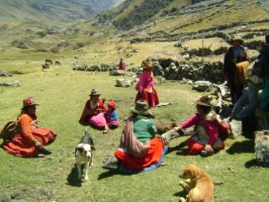
Figure 7. Local women in Huascarán National Park
Information from the Ministry of Labour indicated that in 2007, 80% of the economically active population of the región of Ancash earned less than 600 nuevos soles (ca US$215) per month and half of the workforce earned less than 200 nuevos soles (ca US$72) monthly.
In fact, in 75% of the 32 districts with land within the park and its buffer zone, more than 50% of the population was in a situation of ‘poverty’ or ‘extreme poverty’ and, on average, 31% of the population was ‘poor’, 28% was ‘very poor’, and 41% was classified as ‘not poor’. This measure of poverty was only based on monetary incomes and is therefore a measure of “monetary poverty” (Instituto Nacional de Estadística e Informática 2007; see http://censos.inei.gob.pe/censos2007/ for Ancash).
With respect to economic activities undertaken by heads of households, 64% were involved with ‘agropecuaria’ (farming / livestock raising), 43% having sheep and 39% having cattle. In 2008, each household had an average of 4.1 head of cattle and 7 sheep, with 61% of cattle and 37% of sheep consumed by the family. Thirty-nine percent (39%) of cattle and 63% of sheep were sold for cash. Sales of livestock in 2008 generated, on average, S/.1077 (nuevos soles) / household per year (ca US$371) from cattle and S/.355 (nuevos soles) / household per year from sheep (ca US$122). This represented the equivalent of more than half a year’s salary for half of the economically active population of Ancash and more than 20% of the annual salary of 80% of the regional workforce.
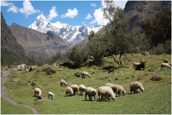
Figure 8. Sheep grazing natural pastures in a quebrada of Huascarán National Park
Changing Circumstances for Management of Grasslands within Huascarán National Park
The economic and cultural importance of many rural activities, including livestock grazing, have changed substantially in Peru in the last 10-20 years. For example, between the periods 1983-87 and 2003-2007, the contribution of agriculture in general to the GDP of the región of Ancash fell from 23% to 8%, while that of mining increased from 6% to 35%, even though the former contributes about 49% of regional employment, while the latter generates about 24%. By 2013, mining contributed 26.2% and agriculture 6.1% of the regional economy (Banco Central de Reserva Del Perú, 2014). The main growth sectors of the región, as assessed from mean annual rates of growth during the decade 2003 – 2013, were: construction (10.4% per annum), restaurants and hotels (6.8% p.a.) and transportation and communications (6.5% p.a.) (Banco Central de Reserva Del Perú, 2014).
Parts of local Andean economies have tended to stagnate, motivating many ‘campesinos’ to join the staggered migrations to urban centres to look for work, mostly as unqualified labourers in the construction industry or in agricultural service areas, to increase family income. Nevertheless, many of these migrants return to their family lands where they contribute to the steady rate of increased exposure of comunidades campesinas to external cultural influences.
Data from the national censuses of 1993 and 2007, suggest that the rate of change through aculturation – that is, the rate of cultural modification of an individual, group, or people by adapting to, or borrowing traits from, another culture – within the buffer zone of HNP is significant. The more traditional, scattered ‘native’ communities, totalling 444 settlements which constituted about 26% of the local population, contained a mixture of 57% of people who maintained ‘traditional’ (‘archaic’) mind-sets and 43% who were ‘progressive’.
While many of the traditional activities and processes are still followed, modern technologies and markets are increasingly influencing the ways in which these communities live and do business. As mentioned above, there has been a general downward trend in the size of rural communities as some people (mostly men) move to urban areas to find paid work. How these migrations and alternative incomes affect the operation of ‘campesino’ communities and, in turn, may affect grazing arrangements within their lands, is yet to be revealed. But, clearly, a significant proportion of the population maintains a progressive outlook towards the inevitability of change.
In addition to the steady changes arising from the global economy and its associated technological products, the increasing affects of global climate change are likely to have more frequent impacts on agricultural and livestock income sources for the ‘campesino’ communities. These climate change affects will also impact upon the natural pastures and bofedales of Huascarán National Park, exacerbating the challenges for achieving conservation and the sustainable management of these ecosystems and the ecosystem services they provide.
Improved conservation management of grasslands within Huascarán National Park
The general principles and guidelines for conservation of biodiversity within Huascarán National Park (HNP), as identified in the latest master plan (2010-2015), include:
• Conservation of the resources of HNP is a shared task between the competent actors and other public and private actors
• Conservation must be in equilibrium with the sustainable well-being of the populations surrounding HNP
• The use of natural resources within HNP should be undertaken responsibly, to ensure that ecosystem services arising from the park are at least maintained, and wherever possible, increased
• The pre-existing rights to the creation of HNP will be exercised under plans of management or other regulatory, planning or management instruments
• The pressure that the grazing usufruct exerts on the pastures should not increase
• The use of pastures should be sustainable, through sensible techniques that the local population can implement.
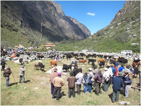
Figure 9. Campesinos and their cattle within a quebrada of Huascarán National Park
With respect to livestock grazing, and cattle in particular, it is important to note that, with a few exceptions, this is an activity conducted mainly within the national park and based on the raising of animals of, generally, a very low quality (SERNANP 2011). In the context of grazing management within Huascarán National Park (HNP), each ‘quebrada’ has one or more Comités de Usuarios de Pastos Naturales (CUPN) (Natural Pasture Users Committee) or ‘Campesino Community’ (CC), with traditional rights for grazing of particular areas. Each committee/community has a spokesperson to represent their group’s interests in working, or negotiating matters, with the park management authority, SERNANP (La Jefatura del SERNANP). There are 62 such CUPNs and CC’s that cover the grazing interests of the 41 ‘quebradas’ listed in the plan maestro for Huascarán (SERNANP 2011).
Consistent with the conditions of their usufruct rights to grazing, it is necessary for the local grazers to comply with Ministerial Resolution No. 1200-80-AA-DGFF, which requires that grazing be conducted “without causing deterioration of the productive capacity of the pasture resources (including burning) or altering the hydrological regime of the basin”.
The master plan for the park has therefore suggested that the local managers (la jefatura) for the park establish a strategy for management of each sub-basin, in such a way that over-grazing, caused in large-part by current livestock raising practices, does not affect the conservation objectives and key attributes of the park. This needs to be undertaken without losing sight of the fact that ongoing access to the communal lands within the national park for grazing of livestock is culturally, socially and economically very important to the local ‘campesino communities’ and families.
The master plan suggests that the actions that each sub-catchment strategy identifies should include (i) the establishment and strengthening of Natural Pasture Users Committees (CUPNs), (ii) the revisión and implementation of relevant regulations, and (iii) the evaluation of the stock-carrying capacities of each sub-catchment. Each management document should aim to achieve both conservation and local development outcomes.
In addition, the master plan notes that “the bofedales wetlands should not, under any circumstances, be disturbed by infrastructure such as irrigation canals, drinking water catchments, ponds, drains for grazing and other structures; that is, except for actions or projects that will help in the recovery of bofedales through water harvesting, and more generally for the conservation of biodiversity. In this latter context, Artícle No. 15 (‘Exploitation of Natural Resources within the Communal Lands) of Law No. 24656 – “Ley General de Comunidades Campesinas” – states that ‘… activities for the utilization of forests, water and other natural resources’, that occur within the lands of Campesino Communities, should be ‘in harmony with the laws and regulations that govern the matter’, and will be a priority for support and protection by the State.
Current and Proposed Projects
While natural grassland pastures constitute 4.5% of HNP, the areas that show some of the greatest impacts from overgrazing by livestock, and that have the greatest potential impact on the provision of ecosystem services in the rest of their catchments, are the areas of wet puna grasslands, and in particular those that are referred to as bofedales. Given the relative importance of these bofedales, a priority for the management of the grasslands of Huascarán National Park is the recovery and sustainable management of the wet puna areas they occur within.
To date, a small number of localised projects have been undertaken or commenced. These are aimed at addressing the current lack of understanding about how best to develop sustainable systems of management for the bofedales so that they maintain, or recover, their ability to hold and regulate water, as well as to improve the quality of the water. This latter point is becoming more important as the retreating glaciers expose more minerals which leach and affect the pH of the water.
Some recent Masters and PhD projects (see references) have examined ecosystem processes to help address this general lack of information, with particular focus on the interrelationship between the sustainable management of pastures and the water and carbon cycles. Research in other areas is examining how these ecological processes connect with sustainable agriculture requirements and what the social, economic and political requirements might be to generate economic incentives that make it easier for stock-grazing families and communities to retain these grassland / bofedales ecosystems.
Each of the local projects being undertaken in the national park is situated within parts of individual ‘quebradas’ and is being conducted with members of the different local Comités de Usuarios de Pastos Naturales (CUPN). As an example of one approach, SERNANP signed a 5-year contract with the community of Unidos Venceremos in 2013, which gave the community the rights to take charge of local tourism and recreational activities within the Chinancocha area of the park. This includes provision of services to hikers such as hire of boats and camping sites and the sale of food and crafts. This was calculated to generate 70 direct jobs for the community. In return, the community gave an undertaking to remove 200 head of cattle and horses from the quebrada Llanganuco y Demanda (see: http://www.rumbosdelperu.com/sernanp-firma-historico-contrato-con-comunidad-campesina-en-parque-nacional-huascaran-V796.html ).
Pasture management has also been improved in quebrada Rajucolta where there has been a large reduction in livestock (cattle) numbers that is resulting in the recovery of the local ecosystems (R. Villanueva, pers. comm. 2 July 2014).
Other projects have included the use of stock exclusion fences to demonstrate and measure some of the more obvious impacts of overgrazing and trampling by livestock, as well as to measure some of the influences on the water cycle. These fenced areas, varying from 1 to 30(+) hectares, are also being used to demonstrate how plant growth and seedling survival can recover when areas are rested from grazing pressures.
The main objectives are for the participative teams established to investigate how to improve the wet puna grassland (bofedal) ecosystem in terms of:
- Recovering the natural conditions of diversity and biomass of the high Andes grassland prairies and wetlands
- Re-establishing sustainable levels of livestock production given the changed and changing environmental circumstances
- Recovering the hydrological functions of the high Andes wetlands, including:
- increasing water capture and storage capacity of the soils, and
- improving water quality and pH levels, especially through filtration (‘capture’) of metallic minerals that are being leached from exposed surfaces as the glaciers retreat as a result of the warming climate
- Recovering the capacity for capturing and storing carbon.
In fact, on this last point, a recent paper by Ward, et al, (2014) indicates that carbon storage by the world’s mountain grasslands and shrublands has been significantly under-estimated and that consideration needs to be given to leveraging climate finance to support the sustainable management of these carbon stocks.
The key to all local projects, however, is the participation of a cross-section of local CUPN members working with protected area staff and scientists to share in the investigation and monitoring work, in the interpretation of results obtained, and then in the implementation of actions identified. Also key to the longer-term success of such projects is the development of leadership on these issues within local CUPNs and an increased engagement with women and younger members of the communities.
References:
Banco Central de Reserva Del Perú, 2014. Caracterización del Departamento de Ancash. Departamento de Estudios Económicos de la Sucursal Trujillo, Sucursal Trujillo del BCRP, Subgerencia de Sucursales, Gerencia Central de Administración, 24 de febrero de 2014. 12 pp.
El Congreso Constituyente Democrático del Peru, 1993. Constitucion Politica del Estado.
Cruz, J. A. 2013. Productividad primaria, captura y almacenamiento de carbono en pastizales alto andinos. Tesis Mag. Sci. Lima – Perú. En Prensa.
Gonzáles, I. E. (In press).Composición de la dieta y consumo de forraje de equinos vacunos en pastizales alto andinos. Lima – Perú.
Huerta Ch., G.L. 2002. Formulación de herramientas de gestión integral para el manejo sostenible de las praderas altoandinas: estudio de caso en la cabecera de microcuenca Quitaracza – cuenca Santa, Sihuas – Ancash. Tesis Ing. Zootecnista. Lima – Perú. 282 p.
INEI, Instituto Nacional de Estadistica e Informatica, 1993; 2007. Censos Nacionales de Poblacion y Vivienda (see http://censos.inei.gob.pe/censos2007/for Ancash).
Mamani M., G. 2001. Zonificación ecológica para la aplicación de estrategias de mejoramiento en praderas naturales de la Microcuenca Rio Negro, Ancash. Tesis Mag. Sci. Lima – Perú. 126 p.
Rumbos del Peru, 2013. http://www.rumbosdelperu.com/sernanp-firma-historico-contrato-con-comunidad-campesina-en-parque-nacional-huascaran-V796.html
SERNANP, 2011. Parque Nacional Huascarán Plan Maestro 2010 – 2015. Servicio Nacional de Areas Naturales Protegidas por el Estado; Junio 2011. See also: www.sernanp.gob.pe/sernanp/bplanesmaestros.jsp
Tácuna, R. E. 2013. Influencia de la incorporación de materia orgánica y la siembra de esquejes de especies nativas sobre la recuperación de un pastizal degradado. Tesis Mag. Sci. Lima – Perú. En Prensa.
Villaneuva, M., 2009. Anexo No. 14. Diagnostico Socio Cultural – Caracterización socio cultural; línea base socio cultural; diagnostico socio cultural del PNH y su zona de influencia. In Parque Nacional Huascarán Plan Maestro 2010-2015.
Ward, A., Dargusch, P., Thomas, S., Liu Y., Fulton, E. A. 2014. A global estimate of carbon stored in the world’s mountain grasslands and shrublands, and the implications for climate policy. Global Environmental Change Volume 28, September 2014, Pages 14–24.
Yalli, T. B. 2013. Influencia del pastoreo diferido con llamas y vacunos sobre la función hídrica del pastizal. Tesis Mag. Sci. Lima –Perú. En Prensa.
Yamasaki K., L.A. 2002. Optimización de estrategias para la conservación y mejoramiento de praderas naturales en la microcuenca Río Negro – Ancash. Tesis Mag. Sci. Lima – Perú. 133 p.