Observation of functioning of Kanchenjunga Conservation Area (KCA): the region’s first community owned conservation area

17.08.2012

  • SUBMITTED ORGANISATION :

  • Wildlife Watch Group (WWG)

  • DATE OF SUBMISSION :

  • 17/08/2012

  • REGION :

  • Southern Asia

  • COUNTRY :

  • Nepal (Taplejung District)

  • SUMMARY :

  • Wildlife Watch Group (WWG) seeks to move ahead to attain the vision for wildlife management in Kanchanjunga conservation Area (KCA). The handover of KCA to the Kanchanjunga Conservation Area Management Council is an example of people managed conservation area. Located in Taplejung district, Kanchenjunga Conservation Area (KCA) is the first protected area of Nepal managed by local communities. This is a bold decision taken by Government of Nepal (GoN) in 2006 to hand over the management of entire protected area to the local people. The GoN, instead of inviting local people to the capital, flew entire Ministry of Forest and Soil Conservation (MoFSC) to the area to handover the management responsibility of KCA. Witnessing the functioning of KCA since last five years, GoN recently declared similar conservation area in the West. This case study titled 'Observation of functioning of Kanchenjunga Conservation Area (KCA): the region's first community owned conservation area ' deals with the aspect of revitalizing local communities through enhancing traditional knowledge and empowering young successors. Vision 2016- a look at what we seek 5 years down the road will empower local people to be able to monitor, evaluate responses and take corrective actions. In order to support the target communities, WWG plays a key role as an enabler by helping with resource mobilization, as a catalyst for action, a source of new ideas and by facilitating research and development. NGOs will have to support local wildlife entrepreneurs to manage and benefit from wildlife management efforts.

  • KEYWORD :

  • KCA, management, livelihood, flora, fauna, NTFPs

  • AUTHOR:

  • Swechha Lamichhane is a young academic born and grown in Nepal. In year 2010 after graduating in environment science she undertook simultaneously as fellow of masters degree of Interdisciplinary Water Resource Management and joined Wildlife Watch Group-WWG as its program associate. Her grasp on conservation related issues grew further when she became the subeditor of the Wildlife Times published by WWG monthly in later days. She recently earned Women to Watch title by VOW, Nepal's O' the Oprah Magazine equivalent. Currently she is one of the team members of WWG's climate change initiative looking closely into climate change impact on flora and fauna in protected areas. Equipped with conservation tools like EIA, remote sensing and GIS application she selectively visited watershed and protected areas in country and abroad to narrate and publish the papers on the subjects. Mangal Shakya is a passionate conservationist in his early forties. Poet and writer by spirit, graduated in management, worked as journalist, and ultimately as conservationist, he has edited and written more than a dozen books related to wildlife, illegal trade, rhino trans-location, CITES, Primate, Conflict and conservation based on his rich and original field association for almost two decades. Travelled widely in nooks and corner of his own country first and later across the globe since last two decades, he founded Wildlife Watch Group and Wildlife Times. He is a country activator of IUCN CEC and member of IUCN CEESP. He participated in the World Water Forum in Hague in 2000 and spoken in series of water related international workshops in countries like Bangladesh.

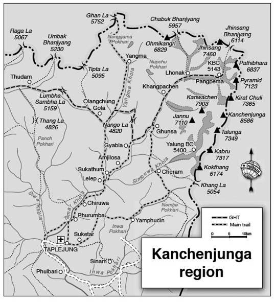
Kanchanjunga Conservation Area (KCA) lies within 670.45’-880.15’ East longitude and 270.30’-280.00 North latitude and located in the Northeastern corner of Nepal.

The Kanchenjunga Conservation Area (KCA) located at the north-eastern part of Nepal as transitional protected areas between Sikkim, India, Tibet Autonomous Region of China and Nepal in Taplejung district. Sankhuwshava district lies at the Western, Tibet at the Northern and Sikkim lies at the Eastern part of it.

The region is home to a diverse population of people of Bhotiya, Chettri, Gurung, Limbu, Rai, Sherpa, Tamang, Tibetan, and Walangpa ethnicity. In recognition of the Kanchenjunga region’s rich biological diversity, the Government of Nepal designated the region a conservation area in 1998. The region’s lands and natural resources were gazetted by the national government, and management responsibility was bestowed upon an internationally funded non-governmental organization, WWF, with cooperation from Nepal’s Department of National Parks and Wildlife Conservation (DNPWC).

Temperature

Temperature and precipitation data analysis between 1987 to 2008 showed some changes. Temperature was in an increasing trend. The Taplejung station data shows that both maximum and minimum temperatures are increasing sharply, with maximum temperature increase of 0.653°C per decade and mean temp increase of 0.3142°C per decade.

Average Precipitation of two driest months, November and December, was in the decreasing trend while that of the wettest months, July and August showed the increasing trend. Also according to the weather data, the precipitation of post-monsoon (October and November) is in the increasing trend.


Population

Within the 2035 square kilometer conservation area, It covers 4 village development committees with 968 households. The total population in this area is 5254. There are 81 user groups (for management purpose as described on management structure which includes conservation area management council and its sub-committees) and 7 user committees.

The population density of the district is 32.8 per sq. km. while growth rate of the district is 1% per annum. The literacy rate of 6 years and above in 1998 was 46.7

About 70% of the respondents taken for the study were of the Sherpa community and 10% were limbus, 9.99% were Rais and only 0.01% was Chhetris. From this, it can be said that about 98.57% of the respondents were of ethnic community and only 1.429% of the respondents were Brahmin and Chhetris.

Ethnic group wise, the major habitants of this area are Tibeto-Burman speaking groups dominated by the Limbus.

Settlement depending on agriculture is closely tied up with forest resources. People are dependent on forest resources. The forest supplies fuel for heating/cooking and fodder for livestock.

Education

The education level of the respondents was divided into categories namely illiterate, literate, primary education, secondary education and university level education. About 68% of the respondents were illiterate, 30% were literate but no formal education and 10% were formally educated. . The literacy rate by gender is 62.4% and 30.6% for male and female.

Socio-economic context

Owing to small and fragmented land holdings in extreme climatic conditions, villagers are entirely dependent on a single crop of potato, while very rarely cultivating barley and buckwheat in small plots. Vulnerability to food deficiency is high. Involvement in activities like permanent hotel business, job, trading, and number of livestock are identified as community level indicators to designate economic levels. Households with low average land holding are still placed at rich category.

Economic levels Household Cultivable Non cultivable Land holding
Rich 13 0.30 0.01 0.31
Middle 17 0.50 0.27 0.77
Poor 37 0.21 0.11 0.32
Poorest 33 0.22 0.06 0.28
Average 0.27 0.11 0.38

(The categories have been based on national economic data)

Their economy is primarily based on trans-Himalayan trade. Livestock raising is an integral part of their livelihood. Although trans-Himalayan trade is gradually declining in the area, livestock products still contribute to villagers’ food requirement. Almost all households raise livestock for purified butter, dry cheese, meat and manure as well as for beasts of burden. Major breeds of livestock are Chauri and Jhopa (cross breed of Yak, Nak and Tibetan Bull) and goats.

Economic levels Household Chauri Jhopa Goat Avg. Livestock holding
Rich 13 26.5 1.5 0.0 28
Middle 17 17.6 3.4 0.8 22
Poor 37 0.9 1.5 1.7 4
Poorest 33 2.1 0.8 2.0 5
Average 7.5 1.6 1.4

Economic activities like hotel/lodge business, handicrafts, petty trade and vegetable production is increasing in KCA.  As a result, the economic demand for alternative income generation and social development activities are also increasing.


Average landholding capacity of community

Landholding(in Ropani) Percentage of household 
Almost landless(<1) 7.143
Marginal (1-4) 14.286
Small (5-10) 35.714


Land use

The study area records 14 types of forest and 195 plant species mostly angiosperm belonging to 160 genera. Wildlife diversity comprised 32 species of mammal, 10 spp of heterofauna, 9 species of fish and 158 species of birds. The status of endangered spp includes 14 spp of plants and 27 spp of wild animals.

Land use types KCAP (%) KCA Landscape complex
Total area 165000 ha. 108803 ha
Forest 14 38
Shrublands 10 19
Grasslands 9 02
Agricultural land 2 19
Rocks/ice & barren land 65 22


Land use Area sq.km. Total area % Vegetated area %
Cultivated land 37.76 1.9 3.9
Rangeland 411.20 20.2 42.3
Forest 521.98 25.7 53.8
Glacier/Snow 659.31 32.4
Rock/Barren 191.95 9.4
Others 212.80 10.4

Employment

Agriculture is the major occupation for 49% of HH in KCA. The major household income source among very low income group is agriculture labor, followed by agriculture activities in own field, non agriculture labor, forestry and petty business. This income group also depends on income from handicraft and small business. Households in the low income group also depend on agriculture activities as well as income group from agriculture labor and petty business and to a lesser extent on forestry, business and handicraft. The middle income group derives a large percentage of income from agriculture as well as labor, petty business and forestry. The high income group derives income from agriculture and international remittance. As most of the people have migrated to the city or abroad, remittance is one of the sources for income.


Migration

Temporary migration of family members is common in KCA; approximately 6.0% (approx. 316 people) of the population is not at home. Such migration has both positive and negative effect, vulnerable households in the study area reported that income from remittance sent by family members working in foreign countries is extremely important to help them meet their basic needs and to accumulate assets, while other households related hardships such as lack of social support and loss of farm and households labor resulting from absence due to travel and search for foreign employment in India, Malaysia and Gulf countries.

Energy use

About 60% of the households in the KCA have access to solar power. Kerosene is the next most popular source of energy for lighting (32%). All the HH in KCA continue to use fuel wood as a source of energy for cooking. The annual mean fuel wood bhari used per HH is 157. This requirement is fulfilled from national forests, community forests, private forests, agricultural residuals and purchase. Alternative energy source include kerosene, charcoal and leaf litter.

Land type ownership and farming

84.4% HH in KCA owns their land for cultivation. Land holdings vary significantly by area and income groups.

Crop production varies among VDCs. Rice, maize, barley and potatoes are the major crops grown. 94.7% HH in KCA grow vegetable. 45.4% raise cardamom as their major income source.

Livestock holding

Almost all HHs in the KCA own one or more livestock such as cows, goats and poultry.

Food security

91.6% HH in KCA have a food deficit for periods ranging from one month to a whole year. On average, there is an annual food deficit for 6-11 months. More than 85% HH purchase food from local market at the time of deficit.


Wildlife

The biological diversity of Eastern Nepal is due to its geographical and climatic condition.

Flora

Botanical taxa No of spp/project area No of spp/Nepal
Flowering plants 182 5833
Pteridophytes 10 383
Lichen 3 471
Endemic plant spp 6 246
Endangered plant spp 14 60
HMG/N protected spp 9 21

Fauna

Taxa No of spp/project area Spp richness of Nepal
Mammals 31 185
Reptiles 6 100
Amphibians 4 43
Fish 9 185
Birds 158 847

The common bird species in local area, grazing land, cultivated land and riverine area include: Kalij pheasant, cattle egret, common dove, red billed blue whistling thrush, magpie, bulbuls, eagles, crow, parrot, shrike, minivet, black drongo, woodpecker, rupy, babblers, owls, pigeons, swallow, sparrow and finches.

Snow leopard is one of the most important wildlife species found in the Kanchanjunga area as it is endangered as well as susceptible species. Snow leopard are hunted for their pelt and killed by farmers because they predate on livestock. Other wild animal species found are grey wolf, musk deer, blue sheep, common leopard and red panda.

Blue sheep is a moderately large mountain ungulate. Four sub species of blue sheep inhabit the world and are found in the remote and high Himalayas of Nepal, Tibet, China, India, Pakistan, Bhutan and possibly Tajikistan.

In 2006, its population in KCA was 1157. In 2007, it was 1167. Likewise, it reached 1335 in 2009. KCA now supports a population of 1372 blue sheep till 2010.

Blue sheep harvest is a possible alternative livelihood option. The chief aim of blue sheep harvest is to generate sustainable source of funding through sustained harvest to provide maximum benefit to local community.

Forestry

The high floristic diversity of this region is due to the presence of diverse ecological habitats. Habitats include marshes, river gullies, and steep slopes with crevices, verdant valleys and dry alpine grasslands.

Forest types:

Tropical Evergreen Forest of Shorea robusta is in the outer foothills below 1000m; Subtropical evergreen and semi evergreen forest in areas of high rainfall on the outer foothills (700-1800m). In the higher fills, lower temperate mixed broad leaved forest (1650-2300 m); Upper temperate mixed broad leaved forest (2650-3350m); Rhododendron forest (3000-4000m); Betula utilis forest (3600-4150m) and Juniperus indica and Rhododendron scrubland forest (3800-4500m).

The forest and forest products are thus exploited by local people in many ways. The loss of biodiversity and degradation of forests in many places can be attributed to unmanaged timber and firewood collection, unsustainable medicinal herbs collection and regular forest fires in the summer. Many resident species are expected to be endangered or threatened. They are Bergenia ciliate, Coriaria terminalis, Dactylorhiza hatagirea, Dubyaeahispida, Larix griffithiana, Meizotropis peliita, Michelia kisopa, Nardostachys grandiflora, Rheum emodi, Rhododendron lanatium, Taxus baccata and Tetracentron sinense.


Non Timber Forest Products:

Non Timber Forest Products is one of the important livelihood options for people of KCA. Some of economically significant NTFPs are:

Lokta: It is commonly available in the middle hills and lower high hills and locally known as kagate, kagati, seto/pahenlo baruwa or argheli.

There are two types of lokta found in KCA region. In the lower hills, Daphne papyracea (pahenlo baruwa or argheli) is available but yields poor quality paper. At high altitude, Daphne bhohra, yields good quality paper.

Harvesting and marketing of lokta in the area is inhibited by lack of paper processing facilities. Incentives should be given to encourage local people to run such small scale cottage industry in other VDCs.

Allo: Girardinia palmate is widely distributed in the mid hills of Taplejung. It is locally known as bhangre sisnu. It is use to make various types of cordage, bags and sacs, and low quality garments. A training program that promotes extensive use of the plant as a generating source within the bounds of sustainability should be launched.

Malingo: Arundinaria malingo is very common in the high hills.

Cardamom:  The cultivation of cardamom (Amomum sublatum) started only 6-7 years ago and is now regarded as the cash crop in the hills of Taplejung. The area has good scope for continued cardamom cultivation, its importance in improving the economic well being of local people as well as soil conservation.

Medicinal herbs: KCA is rich in the diversity of medicinal plants. Important medicinal herbs growing in the high hills are chiraito (Swertia angustifolia), Jatamasi (Nardosachys jatamasi), paanch aunle (Dactylorhiza hatagirea), Kutki (Picrorhiza kurroa), padamchal (Rheum emodi), pashanved (Bergenia ciliate), budo okhati (Astible rivularis), khokim (Bergenia purpurascens) and seto bikhma (Aconitum palmatum).

Ten years ago, the medicinal plants were commonly available. However, due to unmanaged exploitation, only small amounts of these herbs can now be found in nature. Local administration has restricted collection of these threatened herbs.

[Collection of fuelwood and timbers by the local people]


Tourism:

The place of touristic importance is Chiruwa that has abundant bird life, breathtaking rock gorges and scenic beauty. Amjillassa and Gyapla have the enchanting scenery of riverbank of Ghunsa with dense forest area. The green pastures and a settlement are another factor adding to the beauty of the area. Gyapla ghunsa is important for Gumba. This area is opened to foreigners only from 1990. The number of trekkers and tourists reached 1000 in 2001.

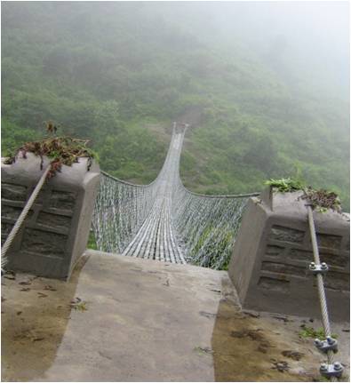
[Suspension bridge: means of movement of local people]


Status of threat levels

The status of the threat caused by socio-economic activity was found to be depletion of forest resources and wildlife. The higher the population, the higher was demand for food, fuel and fodder and NTFP.

Although Kanchanjunga area has biological richness, it is facing serious threat to habitat destruction due to human pressure. The threats in the project area are slash and burn agriculture, overgrazing, poaching of threatened wildlife and out-migration and cultural decline.

The level of awareness about the need of and importance of bio-diversity conservation is at low level. It is because of poverty and economic deprivation and their immediate requirement of the forest resources in their daily lives.

Methodology

Preliminary study:

The team has involved in desk study of relevant secondary information which are project technical reports, independent research studies, development and conservation impact indicators and impact assessment reports, prior to and after coming back from the field. The team has held number of meetings and discussions in Kathmandu with representatives of Department of National Park and Wildlife Conservation (DNPWC) and WWF Nepal Program officials on the project strategies and field level programs and activities. The evaluation indicators, tools and checklists were finalized by incorporating feedbacks and suggestions of WWF Nepal and DNPWC.

Field study:

Prior to field visit, WWG held meeting with KCAP staff to understand and provide overview on KCAP programs and management system by focusing appropriateness of strategies in establishing an effective KCA management system whereby DNPWC manages the KCA through community-based organizations. Extensive focus group discussion, key informant interviews, interactions with institutional members and case studies on relevant issues were conducted.

Governance

Since 6 years, despite the various adversity and challenges, Kanchenjunga Conservation Area Project (KCAP) has managed to fulfill its objectives but even as we appreciate and applaud the effort the one of a kind protected is management practice and its impact on such conservation practice is yet to be evaluated.

Declared as “A Gift to the Earth (1997)”, the Kanchenjunga Conservation Area (KCA) is known for its rich biodiversity, its spectacular scenery of Mt Kanchenjunga(8,586m), and rich cultural heritage represented by the 5,254 inhabitants Committees (VDCs) of Lelep, Olangchungola, Tapethok and Yamphudin.

On March 22, 1998, with the technical and financial support from WWF Nepal, the Department of National Parks and Wildlife Conservation (DNPWC) launched the Kanchenjunga Conservation Area Project or KCAP. The aim was to conserve globally threatened wildlife species such as the snow leopard combined with local development activities like the promotion of health services, informal education, and income generating activities. The KCA also falls within the Sacred Himalayan Landscape, a landscape approach for biodiversity conservation and improving livelihoods in the Eastern Himalaya. Since 1998, WWF has invested US$ 1.5 million in KCA undertaking initiatives to conserve and protect the flora and fauna while also focusing on programs to improve livelihood, as well as educational and advocacy programs. In 2000, the Conservation Area Government Management Regulation was formulated while the territory of KCA was extended from 1,659sq.kms to 2,035sq.kms.

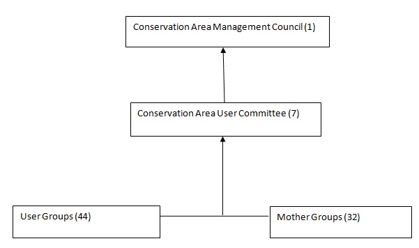
Ever since the initiation of KCAP, the local communities of Kanchenjunga have long expressed their eagerness to take on the responsibility of the conservation area. With this perspective the KCA Management Council (KCAMC) was formed in 2000 which was represented by all stakeholders from the seven Conservation Area User Committees, 44 User Groups, and 32 Mother Groups. The KCAMC in July 2004 submitted the Kanchenjunga Conservation Area Management Plan to the DNPWC. The goal of the management plan is that biodiversity of KCA is managed by local communities to ensure ecological integrity and bring socio-economic benefits. The management plan was approved by the Cabinet of the Government of Nepal on August 31, 2006. On September 22, 2006, a formal handover of KCA to the local management council KCAMC was organized. Late Mr Gopal Rai, Minister of State for Forests and Soil Conservation, handed over a Certificate of Authority to late Mr. Dawa Tchering Sherpa, Chairperson of the management council, for the management of the conservation area at a ceremony. This ceremony was attended by international and national conservationists, government dignitaries, friends and supporters as well as national media. This historic step shows the commitment of the Government of Nepal towards the devolution of power to local communities, especially with regard to natural resources and equitable sharing of benefits.

Management Structure

The conservation area management council has mobilized user groups, mother groups and committees for effective management of KCA. The management is done through 7 conservation committees. These committees execute the working and functioning of user groups, mother groups, forest user groups, snow leopard conservation sub committees and eco-clubs.


Practical progress
Many local residents stated that KCA activities have been limited to only a few villages, while KCA promises to provide support to other villages have thus far not been fulfilled. Indeed, in most areas of the KCA, the presence of tangible environmental conservation and community development programs remains noticeably absent. Many villages continue to lack clear forest management guidelines, and there are few schools and basic health care facilities beyond the ones that have been established independently of the KCA by a couple grassroots international volunteer organizations that have been active in the area.

Office infrastructure

KCA has implemented little in the way of environmental protection measures since the subsistence needs of the area’s relatively dispersed population are considered to have a low impact on natural resources. In ecologically sensitive alpine areas affected by trekking and climbing tourism, KCA staff has taken a more active role. For example, KCA staff encouraged youth from Ghunsa village to organize a clean-up of the base camps on the north side of Jannu and Kanchenjunga peaks. In addition, KCA staff constructed garbage pits, out-house style toilets, and porter shelters in a couple of remote camping locations visited by trekking groups.

The project:

With accumulation of all the important data of KCA and understanding the threats of KCA, WWG has created a project Vision-2016: a look at what WWG seeks 5 years down the road. The goal of the project is to integrate conservation and development by improving the socio-economic conditions of the local people, and safeguarding the biodiversity of the area. The project will accomplish this by strengthening the capacity of local institutions responsible for resource management decisions and conservation in KCA.

The project seeks to reconcile conservation and alternative land usage throughout the ecosystem by focusing on villagers within the system as the recipients of economic and social benefits created by the reserve. The conservation area must contribute to rural development; limited tourism should be balanced with conservation objectives and economic benefits it will bring locally. The single most important aspect of the plan will be to demonstrate to the local people that they can benefit from the conservation area economically. KCAP seeks to establish an ecologically sustainable and economically robust Conservation Area.

WWG sees the days when local communities are keepers of the local wildlife and are at peace with nature. By 2016, we hope to have created a regional security net for our endangered wildlife with the international community’s constant support for new incentives for conservation.

Objective:

  • to improve sustainable use of natural resources by assisting local people to formulate and implement management of the resources
  • to increase women’s participation in development programs by giving non formal education
  • to improve tourism infrastructure and community infrastructure
  • to develop and implement protected area management plan
  • to increase the management capacity of local level departments
  • to increase community awareness regarding the conservation and management of natural resources.


Summary:

It is necessary to implement the action plans for better livelihood options for the people as well as for the development of KCA. With the increase in eco tourism in the region, people will have more alternative livelihood option.

For that, Vision 2016 is a perfect platform to understand and explore the significance of local resources. This will be a one of a kind project to bring together the local people in utilizing the resources.