Nepal: Agro-Pastoralism by Sherpa Communities in the North-Eastern Mountains
06.03.2012
-
SUBMITTED ORGANISATION :
-
United Nations University Institute for the Advanced Study of Sustainability (UNU-IAS); Japan Wildlife Research Center (JWRC)
-
DATE OF SUBMISSION :
-
06/03/2012
-
REGION :
-
Southern Asia
-
COUNTRY :
-
Nepal (Solu-Khumbu District)
-
SUMMARY :
-
This study was commissioned to be included in the publication “Socio-ecological Production Landscapes in Asia”. This chapter provides an overview of rangeland management and pastoralism in the area.
-
KEYWORD :
-
Agro-pastoralism, rangeland, transhumance
-
AUTHOR:
-
Japan Wildlife Research Center (JWRC); Kaoru Ichikawa (UNU-IAS), ed.
-
LINK:
-
http://collections.unu.edu/eserv/UNU:5448/SEPL_in_Asia_report_2nd_Printing.web.pdf
Summary Sheet
The summary sheet for this case study is available here.
Background
[Note: this case study originally appeared in the publication Socio-ecological Production Landscapes in Asia.]
Nepal is a mountainous country in Central Asia situated between China to the North and India to the East, West and South. Geographically it extends between the latitudes of 26 and 30 degrees north. About 2,200 km of the Himalayan range lies along the northern border of Nepal. Of the 14,7181 km2 land area of Nepal, 86% is mountainous and the remaining 14% consists of flatlands. About 39.6% of the national land is under forests, 12% under grasslands and 21% agricultural land (MoFSC, 2009). Due to its acute altitudinal variation (67–8,848 m asl) and unique geographical position, Nepal has wide-ranging climatic and environmental diversity within a north-south distance of only approximately 200 km. The lowland plain areas with a subtropical monsoon climate in the southern belt (< 300 m asl), mid-range mountains with a temperate climate in the hilly areas (300–2,500 m asl ) and the high mountains with a cold temperate and boreal climate in the northern belt (above 2,500m asl). Such diverse conditions have provided Nepal with a rich complement of ecosystems and wide biological diversity.
The Himalayas can be largely divided into four geographical areas: the northwestern, western, central and eastern zones. The eastern zone is located in the part of the Himalayas that largely extends in an arc to the south, with high precipitation and the temperatures of a subtropical climate. The stronger influence of the monsoon in the eastern zone provides plants with a favorable environment in terms of water and temperature, which are important elements for their growth, leading to the substantial forest cover in that zone. The substantial difference in elevation in the mountainous areas creates a variety of vegetation at different elevations (Yamamoto and Tsuchiya, 2000). In the lowlands, it is possible to see Shorea robusta, a dominant tree found in Southeast Asian tropical forests. As the elevation increases, lucidophyllous trees such as Castanopsis and Quercus become dominant. The highlands at an altitude of 3,000-3,800 m at the alpine tree line are covered with Abies forests, while those at higher altitudes with forests of shrubs as high as around one meter, including Juniperus recurua and Rhododendron anthopogon. Even higher are the alpine grasslands stretching up to an altitude of almost 5,000 m, serving as natural rangelands in summer (Yamamoto and Tsuchiya, 2000).
Nepal is a multicultural and multilingual country with significant ethnic diversity. In Nepal a system of direct rule called the “Panchayat” system continued until 1990. However, after the pro-democracy movement became rampant across the country in 1990, a Multiparty Democracy was established and the Local Development Act came into effect in 1992. Accordingly, the local Panchayats (local level administrative units) were substituted for by Village Development Committees (VDC) and their higher level counterparts were termed District Development Committees (DDC) (Tatsumi, 2005). The monarchy came under the new constitution of Nepal. Due to the growing level of poverty, social discrimination, unemployment and political unrest, Nepal suffered a decade-long armed conflict. Finally, Nepal was declared a Federal Democratic Republic in 2008 after overthrowing the historical monarchy and is now in a political transition while building its new constitution. The VDCs and DDCs still continue as the governance units operating at the local and district levels, respectively. Nepal’s total population in 2011 is estimated at about 26.6 million (CBS, 2011). Local level decision-making occurs at the community level, VDC level, municipality level and at the district level. Nepal is mainly an agrarian country with considerable potential, among others, for tourism, hydroelectric power development, biological resources and high value medicinal and aromatic plants. Due to the prevalence of traditional farming systems, communities still have a rich store of traditional knowledge concerning the most effective management of local natural resources, such as agriculture, livestock and forestry.
Characteristics of the Agro- Pastoralism in the Mountain Areas
Junibesi Valley, Solu-Khumbu District
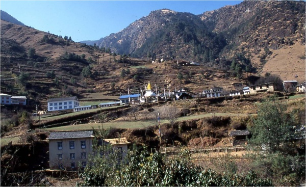
Photo 1. Junbesi (2,700 m asl) (Photo: Tetsuya Inamura)
The mountain farming system, which can be considered as one of the SEPLs in Nepal is characterized by being labor intensive, complex and subsistent on the natural environment. This section describes agropastoralism by Sherpa communities using an example from the Junibesi Valley of the Beni Village in the Solu-Khumbu district of Nepal (Photo 1). The Solu-Khumbu district, located in the northernmost part of the Sagarmatha zone in Nepal has an area of around 3,300 km2 (Kano, 2000), and is inhabited mainly by Sherpa people. The Sherpa are mountain people who are said to have migrated from eastern Tibet passing over the Himalayas in the 16th century. Sherpa settlers have developed their current form of agriculture and pastoralism by adapting themselves to a topography with large differences in elevation, and have traded with the Tibetans for goods, including the fragrant wood used for their rituals (Yuki et al., 2000). In the 1970s, a rise in the popularity of tourism occurred and as the tourist industry progressed and its proportional contribution to the economy of the Solukhumbu Sherpas steadily rose (Yuki et al., 2000). Beni village in the Solu region is composed of around 22 settlements with about 260 households in total, largely populated by Sherpas (Inamura et al., 2000a). Junbesi is a valley with moderate slopes within the Beni village situated at an altitude of 2,500-3,000 m and is covered by extensive moraine and alluvial deposits that communities of shrubs and herbaceous species have colonized. In the upper reaches of the streams, glacial troughs with a U-shaped cross-section occur and behind these a table-like highland extends at an altitude of 4,500-5,000 m. The topography is very undulating with many glacial cirques surrounded by crags at around 5,000 m above sea level, and is largely covered with cliffs and boulders, leaving little area for rangelands (Inamura et al., 2000b).
The Junbesi Valley has a mild climate but high precipitation as it is situated on the southern side of Mt. Numbur, a vanguard mountain of the Himalayas, which the southern moist airstream encounters and then brings much rain during the monsoon season from June to September. In particular it rains all day long from mid-July to September. From December onwards, it becomes a full-fledged winter, and is covered with accumulated snow. In terms of the latitude, however, the valley belongs to the subtropical zone, and hence its climate is relatively mild, resulting in only several to 10 centimeters of snow accumulation at the foot of the mountains (Honma, 2000).
Farming and Transhumance
The Sherpa residents in the Junbesi Valley largely practice agriculture, and some of them are also engaged in keeping herds of “naks” (female yaks) and “zoms” (a single crossbreed between yaks and cows) (Photo 2). Zoms, which yield more milk than naks, are kept for milking after calving (Inamura and Hongo, 2000). The method of rearing naks and zoms takes the form of transhumance, in which the cattle move around the rangelands at different altitudes according to the natural climatic cycles. These livestock are grazed in such forests as Castanopsis and Quercus species located near agricultural lands in the vicinity of settlements during the winter season and are gradually transferred to the upper reaches of valley streams during the period between late March and early April. As the monsoon rain starting from mid-June stimulates the sprouting of grasses on the plateau, the livestock are grazed in summer camp site pastures set up at around 4,500 m above sea level from August to September. They are then brought back to the Sherpa settlements, while maintaining feeding in the form of glade grazing on their way back in October when the temperature declines sharply (Kumagai, 2005). During the migration of livestock from the settlements to the summer camp sites, they are fed such herbaceous species and shrubs as Abies that grow in the forests (Yamamoto et al., 2000). The transhumance in the Junbesi Valley is characterized by its vertical migration over a relatively short distance despite the significant difference in the elevation of migration from the settlements at an altitude of 2,500-3,000 m to the rangelands at nearly 4,500 m (Iwata, 2000).
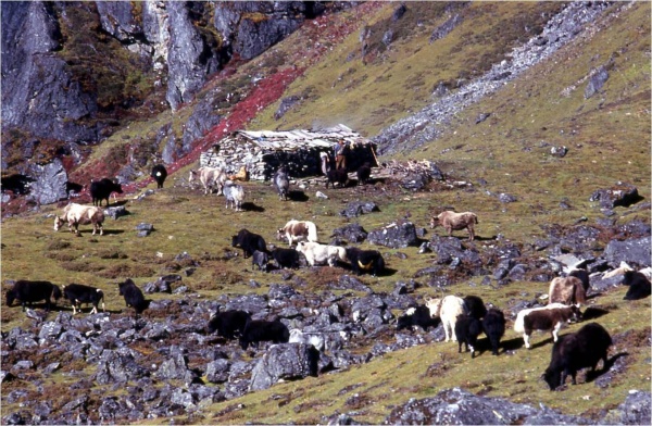
Photo 2. Rangeland for yaks in summer (4,300m asl) (Photo: Tetsuya Inamura)
In the Junbesi Valley, agricultural land extends up to 3,000 m asl in the vicinity of the settlements with the main products including grains such as wheat, barley, corn and potatoes. Corn and potatoes are cultivated as summer crops, while wheat and barley are planted in winter, when crop cultivation is made possible by the lower elevation of the valley. In addition to these staple food crops and potatoes, beans and vegetables are also cultivated in the valley. In the 1970s, the pomiculture of apples and peaches started and the beginning of their commercialization was marked by the supply of these fruits to the periodic local markets that have recently been established, as well as to the lodges for trekkers (Kano, 2001).
Agricultural weeds are extensively used as forage in Junibesi. For example, the weeds are cut down together with the stalk, leaf and other residues of the corn plants left in the field after the harvest during the period between mid-September and October, and are then dried and stored as forage for the winter (Kano, 2001). The use of weeds for forage is partly due to the significant fluctuation in the availability of forage due to seasonal changes. During the seasons from spring to autumn, there are plenty of plants thriving due to the higher temperatures and abundant precipitation, while in winter, most of the grasses in the grasslands die down, when the shortage of this forage is compensated for by the use of weeds (after they are dried and stored) as a substitute (Hongo and Fujikura, 2000).
Rangeland Management
The Sherpas have patrilineal clans called ru and those in the Solu region, in principle, have organized themselves into a single clan for each settlement. In the Junbesi Valley, land along it was demarcated according to valleys and ridges and has been occupied by the clans in a mosaic pattern. The plots of land held by the clans are not in a single area, but in the form of multiple plots scattered from the lower areas to the higher areas. These lands have been used for transhumance using yaks and zoms. Access to them is restricted to members of the clan concerned, and hence the forests and grasslands to be used as rangelands have customarily been managed by the same clan as they are treated as commons with access restricted to their members (Inamura et al., 2000a). Access to each rangeland is subject to the clan’s rules. The Lama clan, for instance, has an agreement that no one can enter the area beyond the rangeland in summer known as basa before a certain date during the period between late June and July (one day in Shrawan month in the Nepali Calendar). Thus, the rangeland is managed on a clan basis to ensure that pastures in the rangeland upstream from the basa can grow well (Inamura et al., 2000b). As for non-members, they have to pay a certain fee to the clan chief called Mizar to get permission to use the rangeland, although forests around the settlements and fields are available to everyone in the community (Furukawa and Tsuchiya, 2000).
Transhumance in Other Areas
The Khumbu region in the Solu-Khumbu district is situated in a basin-like highland composed of various broad valleys between the vanguard and the border mountain ranges, where there are settlements at an altitude of 3,900-4,200 m, around 1,000- 1,500 m higher than the Junbesi Valley. In the Khumbu region, a lower level of snow accumulation makes it possible to graze on the south-facing slopes in the highlands at an altitude of over 4,000 m, even in winter. Agricultural lands extend up to areas at an altitude of 4,300 m, which is the agricultural limit line. The Sherpas in this region practice a form of transhumance with multiple plots of arable land, rangelands and houses on sites at different altitudes in specific valleys, while, in the Junbesi Valley, farming is limited to areas around the settlements and their transhumance is separate from other cultivation practices (Kano, 2001). Based on the climatic cycle, the Khumbu Sherpas also practice transhumance by going up to the highland in summer and coming down to areas at a lower altitude in the autumn. Moreover, during the period between late autumn and early spring, they again practice transhumance in the highlands using the hay that was cut in the autumn and stored in highland houses in order to cope with the shortage of forage in winter. Transhumance in winter is also intended to enable fertilizer to be applied to the scattered arable land as barley and potatoes are cultivated up to areas at an altitude of 4,300 m, the agricultural limit line (Inamura et al., 2000b).
Unlike in the Junbesi Valley, a village in the Khumbu region is composed of multiple clans and there are no plots of land occupied by any particular clan. It is the keepers called nawa, assigned by each village, who make the decisions on the timing of livestock migration and take charge of the use and management of the forests. The nawa of the livestock protect the crops in the fields from the livestock by moving them out of the village during the cropping seasons, while they leave the pastures on the rangelands to grow well by moving them back to the village during non-cropping seasons (Furukawa et al., 2000; Uprety, 2008).
Challenges and Responses
All national forests were nationalized in 1957 and the Nepalese Forest Act of 1993 clearly mentions that the ownership of forests rests with the state. However, the lands under the control of those at the bottom of the state hierarchy were in effect beyond the control of the state. Thus, in the Junbesi Valley, the lands were managed by the clans. Under the Forest Act, the management of forests, which had hitherto been allocated to each of the clans, was transferred to Community Forestry Users Groups known as saudaya by designating them “community forests.” Community Forests are demarcated by the samdaya in a manner whereby the forests and grasslands around settlements are enclosed as communal lands. This system is in conflict with the Sherpa’s existing land use pattern in which the rangelands along the migratory routes of the livestock, located far from their settlements, are also used for grazing, leading to friction among the users. In the Junbesi Valley, for example, a village where the majority of the population is a clan called Salaka established a samdaya that acquired occupancy rights over a vast area of forests and grasslands around their settlements. The area covered by these occupancy rights includes many rangelands that have traditionally been used and occupied by the Lama clan. Some of the Lama clan, however, do not accept the legitimacy of the samdaya system and continue to practice grazing just as they have done in the past (Banjade et al., 2008; Furukawa et al., 2000).
There are a number of factors contributing to the recent decline in the number of herders. This is considered to be partly attributable to the reduction in the area available for rangelands due to the enforcement of the Forest Act. Other factors include the changing preferences among the new generation and the availability of work in overseas labor markets (Banjade et al., 2008).
The shrinking access to pasture lands due to new legal institutional interventions leaves largely unexploited the natural resources of the grasslands, which is the main endowment of the mountainous areas. Aside from grazing, the herders have used handmade paper produced from the bark of the Daphne bholua plant growing wild in Abies forests (Furukawa and Tsuchiya, 2000). They also collect and trade in high value medicinal and aromatic plants, such as Indian nard or Nardostachys grandiflora and Cordyceps sinensis, for commercial trade and domestic consumption (Parajuli, 1998; Yamamoto et al., 2000). With the decline in grazing opportunities, a good deal of the knowledge about such herbal plants will be gradually lost (Banjade et al., 2008). Planning for new interventions in socio-ecological production landscapes (SEPL) should consider the interests of the indigenous and local communities and the richness of their traditional knowledge in relation to the ecosystem services that have been delivered to communities over the centuries.
References
Banjade, M.R. and Paudel, N.S. 2008. Mobile pastoralism in crisis: challenges, conflicts and status of pasture tenure in Nepal mountains. Journal of Forest and Livelihood. 7(1), p. 49-57.
Central Bureau Statistics (CBS). 2011. “Government of Nepal, National Planning Commission Secretariat”. 2011-07-4. http://www.cbs.gov.np/#. (accessed 2011- 12-18)
Furukawa, A. and Tsuchiya, K. 2000 “Utilization and Management of Forests and Pastures”. Nature of the Himalayas -the World of Sherpa and the Nature of the Mountainous Areas-. Yamamato, N.; Inamura, T. eds. Yasaka Shobo, Tokyo, p.158-168.
Furukawa, A.; Watanabe, K.; Tsuchiya, K. 2000. “The Change of Utilization of Forests”. Nature of the Himalayas -the World of Sherpa and the Nature of the Mountainous Areas-. Yamamato, N.; Inamura, T. eds. Yasaka Shobo, Tokyo, p.275-294.
Hongo, A. and Tokura, Y. 2000. “Weeds Cultivated in the Farmlands”. Nature of the Himalayas -the World of Sherpa and the Nature of the Mountainous Areas-. Yamamato, N.; Inamura, T. eds. Yasaka Shobo, Tokyo, p.119-138.
Honma, K. 2000. “Seasons in the Hymalayas”. Nature of the Himalayas -the World of Sherpa and the Nature of the Mountainous Areas-. Yamamato, N.; Inamura, T. eds. Yasaka Shobo, Tokyo, p.43-54.
Inamura, T.; Furukawa, A.; Yuuki, F.2000a. “People and Communities of the Junbesi Valley”. Nature of the Himalayas -the World of Sherpa and the Nature of the Mountainous Areas-. Yamamato, N.; Inamura, T. eds. Yasaka Shobo, Tokyo, p.71-87.
Inamura, T.; Furukawa, A.; Yuuki, F. 2000b “People and the Livestock Moving up and Down in the Junvesi Valley”. Nature of the Himalayas -the World of Sherpa and the Nature of the Mountainous Areas-. Yamamato, N.; Inamura, T. eds. Yasaka Shobo, Tokyo, p.182-198.
Inamura, T. and Hongo, A. 2000. “Variety of the Livestock and the Mating System”. Nature of the Himalayas -the World of Sherpa and the Nature of the Mountainous Areas-. Yamamato, N.; Inamura, T. eds. Yasaka Shobo, Tokyo, p.171-181.
Iwata, S. 2000 “The Hymalayas, the Roof of the World-the Geographical Formation and the Impact”. Nature of the Himalayas -the World of Sherpa and the Nature of the Mountainous Areas-. Yamamato, N.; Inamura, T. eds. Yasaka Shobo, Tokyo, p.3-22.
Kano, K. 2001. The Sherpa-the 20th Century of the Mountain People-. Meikeido, Tokyo, 277p.
Kumagai, H. 2005. Natural resources management in mountainous areas of northern Nepal- literature survey on the management of pastures, farmlands and forests with the transhumance systems. Institute for Peace Science Center Hiroshima University. IPSHU Research Report. 35, p.91-106.
Ministry of Forests and Soil Conservation, Government of Nepal (MoFSC). 2009. “Nepal Fourth National Report to the Convention on Biological Diversity”. http://www.cbd.int/doc/world/np/np-nr-04-en.pdf. accessed 2011-08-05
Parajuli, D.B. 2008. Cultural dimension of pasture resource management in Nepal: a study of Gumba system of the northwest Dolpa, Occasional Papers in Sociology and Anthropology. 7, p.115-146.
Tatsumi, K. 2005. The roles of local organizations in rural development of the mountain areas of Nepal: limitation of development organizations and potential of indigenous organizations. Hiroshima University Annual Report of Research Center for Regional Geography. 14, p.21-42.
Uprety, L.P. 2008. Role of institutions and organizations for the sustainable management of forest and pastre as common property resources in Nepal: an overview of the indigenous and traditional practices. Dhaulagiri Jounal of Sociology and Anthropology. 2, p.31-64.
Yamamoto, N and Tsuchiya, K. 2000. “Diverse Vegetation of the Nepal Himalayas, from Subtropical Forests to Alpine Grasslands”. The World of Sherpa and the Nature of the Himalayas -the World of Sherpa and the Nature of the Mountainous Areas-. Yamamato, N.; Inamura, T. eds. Yasaka Shobo, Tokyo, p.23-42.
Yamamoto, N; Hongo, A; Tokura, Y. 2000. “Crops, Livestock and Forests”. Nature of the Himalayas -the World of Sherpa and the Nature of the Mountainous Areas-. Yamamato, N.; Inamura, T. eds. Yasaka Shobo, Tokyo, p.101-118.
Yuki, F.; Inamura, T.; Furukawa, A. 2000. “Changes of the Shelpa Community, Associated with the Outside World”. Nature of the Himalayas -the World of Sherpa and the Nature of the Mountainous Areas-. Yamamato, N.; Inamura, T. eds. Yasaka Shobo, Tokyo, p.295-316.