Mainstreaming Community-Conserved Areas (CCAs) for biodiversity conservation in SEPLS - A case study from Nagaland, India
13.12.2019
SUBMITTING ORGANIZATION
The Energy and Resources Institute (TERI)
DATE OF SUBMISSION
13 December 2019
REGION
Asia
COUNTRY
India (Nagaland)
KEYWORDS
CCA; Tizu valley; Sema community; Zunheboto; Nagaland
AUTHOR(S)
Siddharth Edake, Pia Sethi, Yatish Lele
Summary Sheet
The summary sheet for this case study is available here.
Abstract
In Nagaland, located within the Indo-Burma and Himalaya biodiversity hotspots in India, customary rights are protected by the Indian Constitution, and the majority of natural habitats (88.3%) are owned and managed by individuals and clans overseen by village councils, district councils and other traditional institutions. However, in the absence of alternative livelihood options, most of the economic activities in the villages are based upon utilization of natural resources. This has led to over exploitation of forest resources and threats to biodiversity due to the increasing needs of local people. However, in Nagaland, traditional conservation practices have helped protect biodiversity, and there are records of Community-Conserved Areas (CCAs) being declared in the early 1800s, especially in response to forest degradation and loss of wildlife. Thus, the revival of traditional conservation practices through the creation of CCAs offers hope for conservation and ecosystem resilience, as communities set aside parcels of forests within productive, shifting cultivation landscapes. It has been documented that one-third of Nagaland’s villages have constituted CCAs, and as many as 82% of 407 CCAs have completely or partially banned tree felling and/or hunting, and enforce various regulations for conservation. These CCAs, covering more than 1,700 km2, also contribute to carbon storage (an estimated 120.77 tonnes per ha), and are an important mitigation and adaptation strategy for climate change.
A pilot scale project was initiated in the three villages of Sukhai, Kivikhu and Ghukhuyi in Zunheboto district of Nagaland, which aimed at creating and linking Community-Conserved Areas across the landscape and supporting conservation through livelihood creation. The model adopted aimed at strengthening the resilience of these mountain communities and their forests by rejuvenating traditional conservation practices and providing supplementary livelihoods. Activities included compiling information on Indigenous Ecological Knowledge (IEK), developing long-term ecological monitoring mechanisms, motivation and sensitization on landscape conservation and capacity building of the community members in biodiversity identification, documentation and monitoring, as well as promoting ecotourism as a livelihood option. Today, the project has yielded positive results in terms of sustainable use of biological resources by adopting long-term sustainability, enhanced governance and effective conservation of SEPLs. Around 222 species of birds and 200 species of butterflies have been documented and protected by declaring 939 hectares as CCAs and banning hunting and destructive fishing across the remaining landscape of forests and rivers (total area being 3,751 hectares). The positive impacts of the project activities were evident at the end of the project as communities reported increased protection of natural resources after the formation of a joint CCA and improvement in management of common resources of SEPLs. The elders were satisfied with the documentation of their indigenous knowledge in the People’s Biodiversity Registers (PBRs) while the youth, women’s groups and the marginalized members of the community reported increased household income due to ecotourism. This model of biodiversity conservation is being mainstreamed within the governance mechanism and up-scaled through a multi-pronged approach including financial support, legal recognition and long-term ecological monitoring.

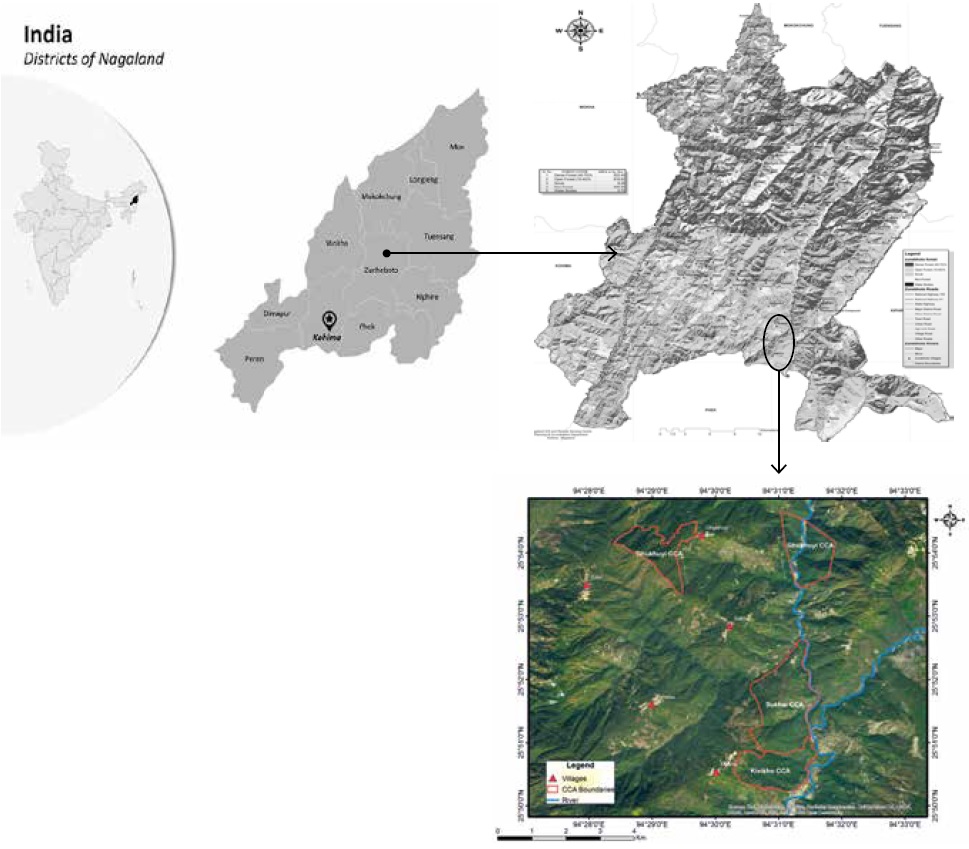

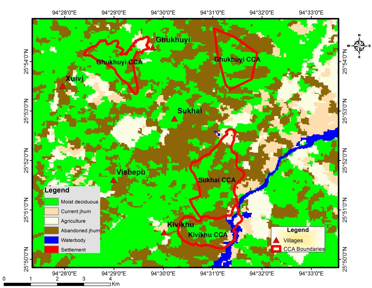
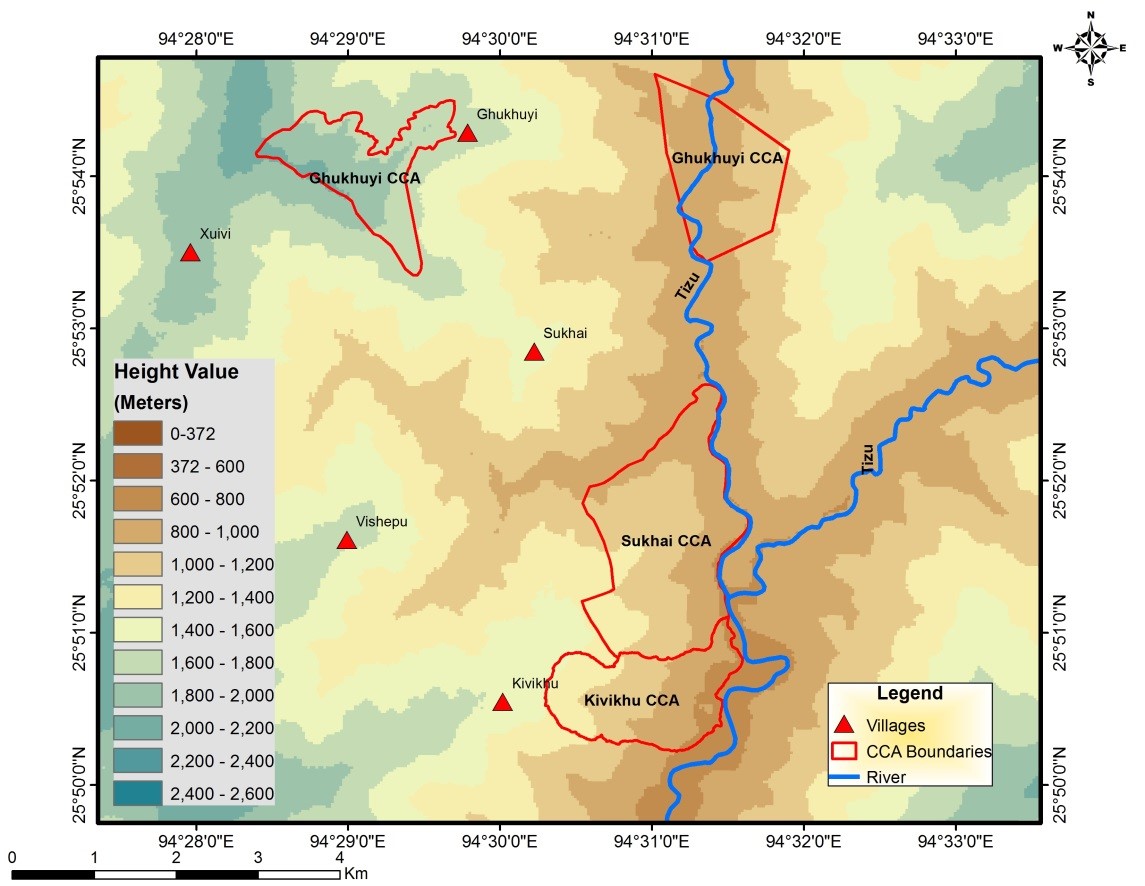
Figure 2. Land use, land cover and contour map of case study sites – CCA (Source: TERI 2017)
1. Introduction
The state of Nagaland in India, which is a part of both the Indo-Burma and Himalaya biodiversity hotspots, has a forest cover of 12,868 km² that accounts for 77.62% of the state’s total geographical area (FSI 2017). It also supports remarkable floral and faunal diversity with high levels of endemism. Naga tribes who inhabit Nagaland follow customary laws and procedures, and their customary rights are protected under Article 371 A of the Constitution of India (see Box 1). These customary laws are plural in nature and differ from tribe to tribe and village to village. The Nagas belong to an oral culture which they have practiced through the ages till present times, where every aspect of life is governed through time-honored customs and practices. These practices have not yet been codified.
Box 1 Article 371 A of the Indian Constitution
Article 371 A: Special provision with respect to the State of Nagaland
Notwithstanding anything in this Constitution, no Act of Parliament in respect of:
– Religious or social practices of Nagas
– Naga customary law and procedure
– Administration of civil & criminal justice involving decisions according to Naga customary law, &
– Ownership and transfer of land and its resources,
… shall apply to the State of Nagaland unless the Legislative Assembly of Nagaland by a resolution so decides.
The governance structure in Nagaland is a combination of customary decision-making processes combined with a statutory system set up by the state and central governments (Pathak and Hazarika, 2012). Hence as per the customary rights, the majority of natural habitats are owned and managed by individuals and clans overseen by village and district councils and other traditional institutions. But, in the absence of alternative livelihood options, most of the economic activity in the villages is based upon utilization of natural resources leading to over exploitation of forest resources. Wildlife hunting has always been a way of life for the Naga tribes, but rampant and unregulated hunting has seriously depleted wildlife populations. Nevertheless, traditional conservation practices help protect biodiversity, and there are records of Community-Conserved Areas being declared in the early 1800s, especially in response to forest degradation and loss of wildlife (Pathak 2009). According to the International Union for the Conservation of Nature, Community-Conserved Areas (CCAs) are defined as, “natural and/or modified ecosystems containing significant biodiversity values, ecological services and cultural values, voluntarily conserved by indigenous, mobile and local communities through customary laws and other effective means” (IUCN 2009). These CCAs include forests, freshwater resources, grasslands as well as agricultural-forest complexes within their ambit. One of the major characteristics of these CCAs is that the communities are the decision-makers, and have the capability to enforce regulations. Regulations and rules range from provisioning rules like patrolling and social fencing to appropriation rules like regulating collection of different forest products, restrictions on grazing, bans on felling of trees or bans on hunting. These bans may take many forms depending on the local situation. For example, a wide range of practices are in force for regulating hunting, which may range from blanket bans on hunting of all species through the year, to seasonal restrictions (e.g. during the breeding season), to bans on hunting particular species believed to be particularly vulnerable. Furthermore, when populations are perceived to be endangered, then the types of hunting weapons may be specified (e.g. use of only traditional traps and snares that are less detrimental than guns, or of fishing nets and traditional traps, while dynamite, electric currents, use of glue and poison are shunned). Similarly, the local communities may restrict wild meat consumption for subsistence purposes, banning the sale of wildlife or forest products in local markets or for commercial purposes. The motivations for declaring the CCA appear to be multiple—foremost being concern for forest degradation, followed by declining numbers of key wildlife species due to hunting and water scarcity (TERI 2015). However, CCAs face numerous challenges in their creation, effectiveness and sustainability and require sustained efforts for their conservation. This case study highlights the importance of Community-Conserved Areas (CCAs) in the socio-ecological production landscape (SEPL) of Nagaland in India.
2. Methods
2.1 Study site
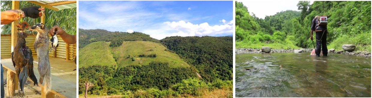
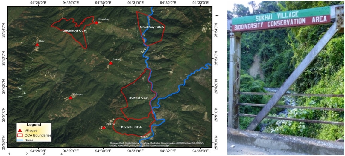
Three villages, Sukhai, Ghukhuyi and Kivikhu, lying in the southern region of Zunheboto district bordering Phek district in the state of Nagaland, were selected as a pilot site under the work initiated by The Energy and Resources Institute (TERI) with support from Conservation International Japan via a Global Environment Facility (GEF) Satoyama grant (see Fig. 1). The pilot site lies in the heart of Nagaland at an altitude of 1,900 m and has sub-tropical wet hill forest primarily overlapping with the sub-tropical pine forest (see Fig. 2). The area acts as an important green corridor between the biodiversity-rich forests of the Satoi range and the Ghosu bird sanctuary and harbors endangered and threatened species like the Blyth’s tragopan (Tragopan blythii), fishing cat (Prionailurus viverrinus) and Chinese pangolin (Manis pentadactyla). The Tizu River, which flows through to these villages, harbors a number of IUCN Red List fish species.
The pilot villages are dominated by the Sema tribe, and the economy is largely agriculture and forest-centered. Though farming is mainly for subsistence, high dependence prevails on the other abundant resources of jhum (shifting cultivation) lands, which include timber, medicinal plants and non-timber forests products. Wildlife is an important resource for the communities and is exploited for various reasons, including food, additional income, cultural practices and as a sport. The overall socio-ecological production landscape (SEPL) comprises of a mosaic of different vegetation types and can be broadly categorized as primary forests, secondary forests, jhum land and plantations.
2.2 Multiple values of the SEPLs and challenging issues faced
The socio-ecological production landscapes of Zunheboto provide the local people with almost all of their daily subsistence and survival needs, apart from contributing to their rich cultural heritage, folklore and traditions. Landscapes of this area are comprised of diverse elements—subtropical forests interspersed with jhum fields and differentially aged, regenerating jhum fallows. Jhum is basically ‘farming the forest’, where patches of forests are cleared for cultivation and then abandoned to fallow for several years. In Nagaland, this system of shifting cultivation ensures that even landless farmers are allocated patches of forest to farm and is perhaps a reason for the high forest cover of Northeast India (Northeastern forests account for 25% of India’s forest cover). Consequently, the people farm in the forest and the two are perceived to be inextricably linked by the local communities. The forests provide enormous benefits to the local communities in terms of ecosystem services such as timber, fuelwood and forest products. Food production is enhanced owing to the location within the forests (for example through enhanced pollination, water flows, nutrient enrichment, and natural fertilizers). The jhum fields sustain a diversity of local varieties of crops (e.g. Miyeghu, which is the local variety of paddy) that feed the people and their livestock. The rivers flowing through their lands irrigate their fields and forests and provide them with fish. In the valley areas adjoining the rivers, the people also grow paddy in a pani-kheti system (water fed agriculture/terrace farming). Local landraces are preferred and grown, including the Naga Mircha (Capsicum chinense) and the Nagaland tree tomato or tamarillo (Cyphomandra betacca), that have recently acquired the Geographical Indication (GI) tag as directed by the Trade Related Aspects of Intellectual Property Rights (TRIPS) agreement.
Traditionally, the Naga tribes had an intimate relationship with nature and their SEPLs are based on a foundation of the interconnectedness of God, people and nature. This is reflected in their rich folklore on the plants and animals of their forests. Some of these stories underline the ecological role that animals play in the ecosystem and their contribution to ‘ecosystem services’ for human beings. For example, the role of the earthworm in enhancing soil fertility is transmitted through a folktale (TERI 2017). The value of their SEPLs was culturally realized and codified through wise use—for example, the killing of pregnant animals and birds was a taboo that would bring misfortune to the hunter and his family. Fishing and the use of certain poisonous roots and leaves that kill fishes in the rivers or springs during the spawning season were also restricted (Lkr & Martemjen 2014).
The Naga people in general consider all land to be sacred. Jhuming, or shifting cultivation, involves clearing the land and burning the jungle, so people propitiate the spirit with rice, crabs and rice beer to beg for forgiveness for the many animals, plants, birds and reptiles that might be inadvertently harmed. The entire lives of the Sema people revolve around their forest-farm landscape. All the cultural festivals of the local people are linked to their agricultural calendar, and the Sema people’s agricultural calendar in turn is attuned to nature, guided by the movement of the stars or of birds—their migration patterns, breeding seasons and songs. For example, the sowing of paddy is initiated only when the constellation of Orion (Phogwosiilesipfemi) is at its zenith or after the kashopapu, a species of cuckoo, is heard calling (Hutton 1921).
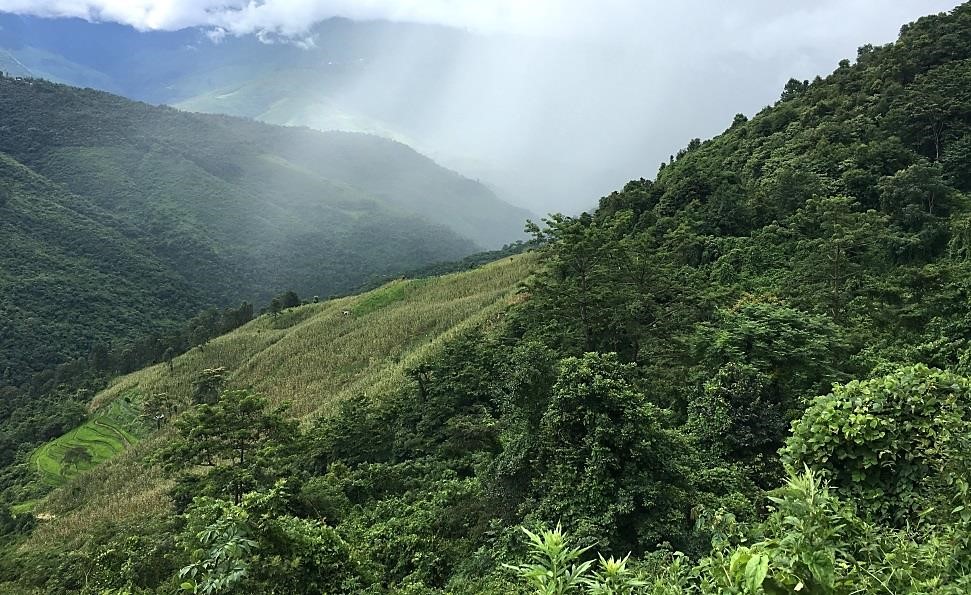
For the local Sema communities, a vibrant well-functioning SEPL implies that abundant wild fauna is present in their forests, and easily sighted when they jhum their fields, and that fish catches are abundant, large-sized and diverse, consisting of many species. Forests are protected at the top of hills so that their watershed services are enhanced. For example, in the pilot village of Kivikhu, the main source of water for drinking and household activities is located 2.5 km from the village boundary on a mountain top in an area that is locally called Shoshemi-ghoki (ghoki meaning stream). Traditionally, lengthening of the jhum cycle provides improved scope for natural biodiversity to regenerate. This is an extremely positive sign as jhuming is an excellent way to protect forests and associated biodiversity and yet produce crops, provided that long fallow periods allow for the forest to regrow (see Fig. 3).
Of the issues currently faced in managing the SEPLs, the main challenge is the decreasing jhum cycles. Earlier when a forest patch was cleared, each patch was cultivated for only one to two years and then left to regenerate for upwards of 15 years. However, the decreasing jhum cycles at present (less than seven years and often only for three to five years) prevent effective regeneration and lead to much soil erosion. Given the dependence of the local community on forest cover for a variety of provisioning and regulating ecosystem services, loss of forest cover has affected agriculture and the availability of water for domestic and agricultural use.
Though wildlife hunting is an age-old practice and a culturally embedded practice in the Naga way of life, the use of guns has become increasingly common, and is popular due to the easier and higher probability of killing prey than traditional ways of hunting. This has led to rapid depletion of wildlife with many species on the brink of local extinction. Aggressive fishing using poisons (such as bleach and lime powder), dynamite and electrocution using battery packs has also led to reduction in fish populations of the Tizu River flowing through the villages. Fear of losing all the fish and the natural ecosystem is one of the reasons that led to local communities to declare a reserve in their mountainscape. As a wise-use practice, they believe that fish and other animal species breed in the reserved areas and their populations are revitalized and replenished over time (see Fig. 4).
2.3 Description of activities
Though a reserve area has been in existence since 2002, it did not contribute to conservation in the absence of a well-delineated program to safeguard ecosystems and conserve SEPLs. To ensure conservation of large contiguous forest areas, it was decided to mobilize support to link the community-conserved areas, revive traditional conservation practices, carry out ecological assessments of these CCAs, develop community-based ecotourism initiatives and formalize and mainstream a network of CCAs along with the Nagaland Government and the State Forest Department.
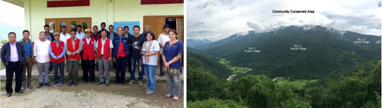
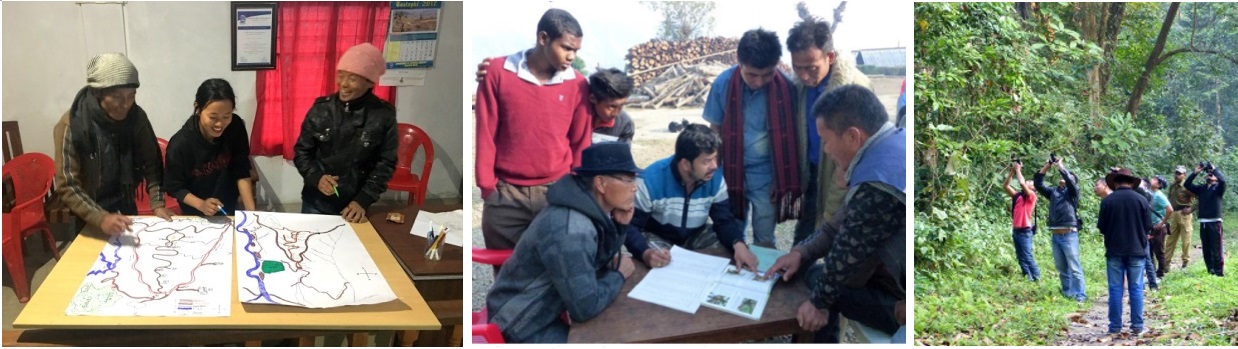
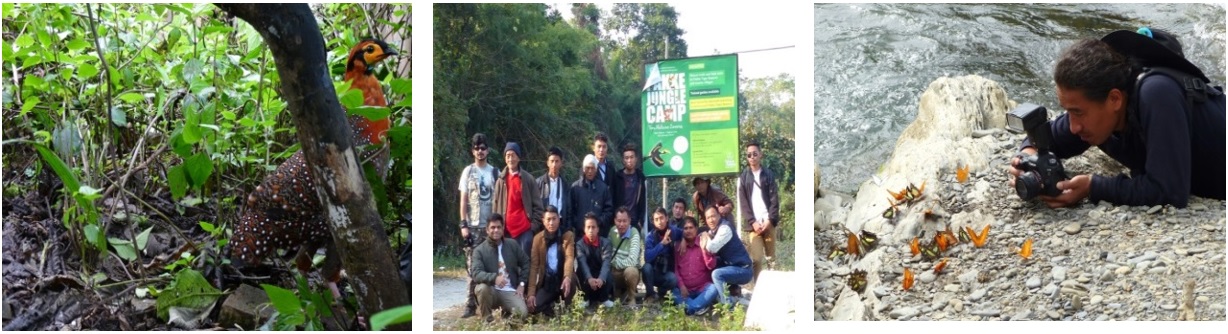
Several deliberations were held with the communities of the three pilot villages of Sukhai, Ghukhuyi, and Kivikhu, to form a joint CCA Management Committee in order to enforce rules that ban hunting, fishing, and logging as well as collection of medicinal plants in the designated CCAs, and to prepare biodiversity registers to document traditional ecological knowledge (TEK). Other activities proposed and carried out by the Tizu Valley Biodiversity Conservation and Livelihood Network (TVBCLN), a formal local CCA body, along with TERI and Titli Trust (an Indian NGO primarily focused on conservation and livelihoods in the Himalayas), were comprised of training the youths in biodiversity assessments and sustainable use of natural resources; preparing resource maps; generating awareness through sensitization campaigns; and promoting ecotourism as an alternative livelihood activity (see Fig. 5 and 6).
3. Results
3.1 Conservation education and sensitization
Community engagement through consultation, conservation education, and public sensitization approaches was used to increase awareness of threats and integrated approaches at the community and stakeholder level. This was achieved through participatory planning, knowledge sharing, and capacity building. Around 30 sensitization campaigns were organized within the three pilot villages and on other community platforms like the local Ahuna festival, thus reaching out to a total of around 1,200 individuals directly, along with a positive impact on more than 10,000 individuals indirectly living in the vicinity of the project site. This resulted in many more villages urging a replication of these methods to manage their SEPLs, the latest being Chipoketa village, adjoining Kivikhu village, which is dominated by the Chakesang community. Also, scientific publications, popular articles, as well as websites (http://nagalandcca.org/ and http://gef-satoyama.net/) have helped to gain the attention of various stakeholders and boosted the engagement. In addition, exposure visits were undertaken for the community members to the neighboring states to showcase similar case studies, success stories and best practices with respect to community conservation.
3.2 Formation & formalization of joint Community-Conserved Areas
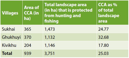
Due to the continuous and intense engagement with the communities, the three villages of Sukhai, Kivikhu and Ghukhuyi in Zunheboto district of Nagaland formally declared around a total of 939 hectares of biodiversity rich forest as community-conserved areas in respective villages, which are now being jointly managed by them (see Figure 1 and Table 1). However, apart from these CCAs, they have also banned hunting and destructive fishing across the entire landscape of their villages, covering 3,751 hectares of forests and rivers. In general, each CCA on average is about 25% of the total landscape area owned by the village, which is quite large. The CCAs were delineated and mapped and the boundaries were well-defined through demarcation, digitization and participatory mapping. This resulted in improved management of common resources. Also, a blanket ban on hunting wild animals and birds, a ban on fishing by use of explosives, chemicals and generators, strict prohibition of cutting of fire-wood/felling of trees, as well as a ban on collection of canes and other non-timber forest products for domestic and/or commercial purposes in the CCAs, have ensured conservation of large contiguous forest areas along with the unique endemic biodiversity they support.
3.3 Biodiversity assessments and preparation of People’s Biodiversity Registers (PBRs)
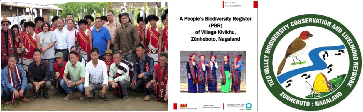
Regular biodiversity surveys in the designated CCAs found an increase in the diversity of birds, reptiles, butterflies and moths with the current checklist listing 222 species of birds, 31 reptiles, 11 amphibians, 200 species of butterflies and more than 200 species of moths. This diversity is very high in comparison to the nearby patches of forest, which do not receive protection and have been documented in the People’s Biodiversity Registers (PBRs) with local and scientific names. These PBRs prepared for the three villages of Sukhai, Kivikhu and Ghukhuyi document the folklore, traditional knowledge, ecology, biodiversity and cultural practices of the locals and help codify the oral knowledge of the communities.
Biodiversity surveys by local communities have strengthened interest in conservation. The youth share pictures of wildlife snapped by them on a “WhatsApp group”. Sightings are recorded in field registers and this has created a conservation community amongst the youth. These sightings are also important for research and are uploaded on websites such as “eBird” and “Birds and Butterflies of India”. Regular assessments can provide information on seasonal variations, range extensions and changes in population abundance. The local people can use this knowledge to develop their own resource monitoring methods. Moreover, camera traps can indicate whether RET species such as the tragopan are still sighted in the area. These surveys, by documenting unique, rare or special fauna, have also acted as a catalyst to attract more outsiders to the area as ecotourists. Well-known local bird guides are now including Zunheboto in their travel itineraries. Given that unidentified species of bats and squirrels have been sighted through these surveys suggests that this documentation will be an invaluable resource base in the future and a contribution to scientific research in the area. A paper on the mandarin trinket snake has been jointly published with an active youth member.
3.4 Alternative livelihood opportunities through ecotourism
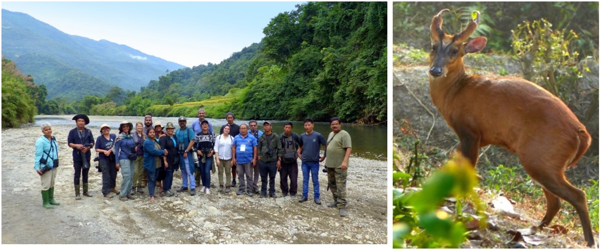
The training of youth in biodiversity assessments and sustainable use of natural resources, as well as the training and capacity building of local community members as nature guides for ecotourism, has resulted in enhanced livelihood opportunities with the steady flow of tourists that are visiting this area to spot ‘bird and butterfly specials’. These include birds like the Naga wren-babbler (Spelaeornis chocolatinus), Hodgson’s frogmouth (Batrachostomus hodgsoni), spot-breasted parrotbill (Paradoxornis guttaticollis) and the grey-headed parrotbill (Paradoxornis gularis), and butterflies like the endemic Naga Emperor (Chitoria naga) and Rufous Silverline (Spindasis evansii). Ecotourists also engage with the local communities to understand their traditions, culture, food and conservation activities. This has further motivated the communities, including those from neighboring villages, to take up conservation and protect their natural resources (see Fig. 7 and 10).
4. Discussion
An assessment by TERI to document the resilience status of pilot villages at the start of the project concluded that the communities were sensitive to the diversity of landscapes within their village. Due to traditional farming and allied conservation practices, they believed that the landscape has good resilience and can regenerate; however, the loss of biodiversity due to illicit tree felling and rampant hunting is irreversible. There was also a good understanding of ecosystem services provided by community areas mainly in the form of water and wild meat. However, the elders of the village also reported that the traditional taboos and beliefs that encouraged wise-use practices in the past may be becoming increasingly irrelevant, in part because of changes in religion, culture and globalisation. While in the short term these CCAs face problems of rule breaking particularly with regard to hunting, in the long-run threatening the very sanctity of these areas are the lost revenues from timber production. As populations grow, land prices rise and people move away from their villages, more private and clan owners of CCA land may want to manage their forests for timber, rather than for conservation.
One important lesson learned through this project is that if communities are well informed and empowered, they can take steps to protect their natural resources and use them judiciously. The project directly helped the communities to strengthen the age-old practice of conserving community forests through mobilization and building synergies. The project also responded to the critical needs of the pilot area by documenting the traditional knowledge and raising awareness on the impacts of anthropogenic activities on the biodiversity and ecosystem services of the CCAs, as well as the ripple effect on the socio-economic and cultural lifestyle of the Sema people. Again, the project through its effort to generate alternative livelihoods built the capacity of communities on ecotourism and is contributing to biodiversity conservation. The positive impacts of the project activities were evident in the second resilience assessment conducted by TERI at the end of the project. The communities reported increases in the protection of natural resources after the formation of jointly managed CCAs, and improvement in management of common resources. The elders were satisfied with the documentation of their traditional and cultural indigenous knowledge in the People’s Biodiversity Registers (PBRs), while the youth, women’s groups and the marginalized members of the community reported increases in their household income due to ecotourism. The protection of a stretch of Tizu River passing along the boundary of a CCA also resulted in an increase of fish-catch downstream.
Local communities are intimately dependent upon the resources provided by their SEPLs and are well aware of the many benefits they receive from their landscapes. However, over time traditional knowledge has eroded and the folklore and practices that supported the wise use of their landscapes are being lost. Nevertheless, the way people perceive certain elements of their landscapes has shifted after this project. In particular, the importance of stopping hunting to increase wildlife abundance is now well supported. The role of wildlife in promoting forest regeneration, and the interconnections of healthy rivers and fish abundance are clearly understood. Increasingly, though slowly, the people realise that forests and biodiversity can also provide economic benefits through livelihood alternatives like ecotourism. Their fast eroding awareness of the importance of healthy SEPLs to their lives and cultures that were once traditionally embedded in their beliefs and practices is now slowly reviving. These changing perceptions have been captured through the second assessment of the indicators of resilience which further underscores that local people now understand the value of banning hunting and fishing for the benefit of future generations.
This project is just the start of what we hope will be a movement for conservation in the State of Nagaland. To date, impacts of the project have been monitored based on indicators and a baseline developed at project initiation. The project has far exceeded our expectations. Since the project is for only two years, another objective was to ensure sustainability of the initiatives. In January 2019, the local communities independently organised a Chengu (Great Barbet) conservation festival which was a vibrant demonstration that the local people were well on their way to independently carrying out conservation.
Future monitoring in villages will be ensured by the Village Councils themselves. The Village Councils have set in place sets of resolutions, and those failing to comply are heavily fined. The local communities now patrol their forests and prevent both outsiders and people from their own villages from hunting and fishing. They also share pictures of those disobeying their rules on a WhatsApp group for quick action, and educate and motivate the people of other villages to eschew hunting. The Tizu Valley Network further supports education and sensitization and livelihood activities. Moreover, the government has taken notice of this initiative and has come forward to support it by developing the area into a Community Reserve under the Indian (Wildlife) Protection Act, for which limited funding is available.
The value of linking CCAs as a network so that they act as refuges for wildlife and enhance connectivity for wildlife movement has now been recognised by the Government of Nagaland. Enabling joint CCAs as formal institutional mechanisms that promote landscape conservation and facilitate nature-based livelihoods is soon to be supported through externally aided projects to strengthen forest and biodiversity management in the State. TERI has also developed a draft policy on CCAs as institutional frameworks for conservation in the State, which has been shared with the Government of Nagaland.
5. Conclusion
The case study of the Tizu Valley Biodiversity Conservation and Livelihood Network’s (TVBCLN) Community-Conserved Areas has yielded positive results in terms of sustainable use of biological resources by adopting long-term sustainability, enhanced governance and effective conservation of SEPLs. Up-scaling of activities initiated by the communities will involve the formalization and mainstreaming of a network of CCAs in the State which are at par with India’s Protected Area (PA) network in conjunction with the Nagaland Government and Forest Department. This will also require technique, finance and institutional support to encourage and sustain the practice of CCA formation and sustainable management. Given that 88.3% of forests are under the governance of the communities in Nagaland, the Community-Conserved Areas (CCAs) constitute the primary method for forest management and conservation of SEPLs in the State. The government needs to provide the policy, technology and the funding needed to allow these conservation groups to perform their role uninterrupted.
Acknowledgements
The authors thank Conservation International (CI) Japan for supporting the project via a GEF-Satoyama grant. Special thanks to the Department of Forests, Ecology, Environment and Wildlife of Nagaland for their guidance and support. Special thanks to Sanjay Sondhi of Titli Trust for his invaluable support and help throughout the project. Thanks to Tshetsholo Naro for his support in the field.
References
Forest Survey of India (FSI) (2017), State of Forest Report, Forest Survey of India, Dehradun.
Hutton, JH 1921, The Sumi Nagas, Macmillan and Co. Limited, London.
International Union for Conservation of Nature (IUCN) 2009, Indigenous and community conserved areas: a bold new frontier for conservation, IUCN, Geneva, Switzerland, viewed 15 February 2019, <https://www.iucn.org/content/indigenous-and-community-conserved-areas-bold-new-frontier-conservation>.
Lkr, L & Martemjen 2014 ‘Biodiversity conservation ethos in Naga folklore and folksongs’, International Journal of Advanced Research, vol. 2, no. 5, pp. 1008-13.
Pathak, N & Hazarika, N 2012, ‘India: Community conservation at a crossroads’ in Protected Landscapes and Wild Biodiversity, eds N Dudley & S. Stolton, Volume 3 in the Values of Protected Landscapes and Seascapes Series, IUCN, Gland, Switzerland.
Pathak, N (ed.) 2009, Community-Conserved Areas in India –A Directory, Kalpavriksh, Pune.
TERI 2015, Documentation of community conserved areas of Nagaland, The Energy and Resources Institute, New Delhi.
TERI 2017, A People’s Biodiversity Register of Kivikhu Village, Zunheboto, Nagaland, The Energy and Resources Institute, New Delhi.