Iraq: Traditional Agriculture by Marsh Arabs in the Southern Marshes
06.03.2012
-
SUBMITTED ORGANISATION :
-
United Nations University Institute for the Advanced Study of Sustainability (UNU-IAS); Japan Wildlife Research Center (JWRC)
-
DATE OF SUBMISSION :
-
06/03/2012
-
REGION :
-
Western Asia
-
COUNTRY :
-
Iraq
-
SUMMARY :
-
This study was commissioned to be included in the publication “Socio-ecological Production Landscapes in Asia”. This chapter provides an overview of the marshes and their traditional use in the area.
-
KEYWORD :
-
wetlands, fishery
-
AUTHOR:
-
Japan Wildlife Research Center (JWRC); Kaoru Ichikawa (UNU-IAS), ed.
-
LINK:
-
http://collections.unu.edu/eserv/UNU:5448/SEPL_in_Asia_report_2nd_Printing.web.pdf
Summary Sheet
The summary sheet for this case study is available here.
Background
[Note: this case study originally appeared in the publication Socio-ecological Production Landscapes in Asia.]
Iraq’s southern marshes (Mesopotamian marshes) are located at the point where the Tigris and Euphrates rivers meet, spreading over the so-called “Fertile Crescent.” Almost the whole area of the country has a desert climate, and the summer season is dry, boosting the maximum temperature above 50°C. In Basrah, the central city of southern Iraq, the world’s highest temperature (58.8°C) was recorded in 1921. Even in this hot, dry climate, the streams of the Tigris and Euphrates maintain the southern marshes, which boast the largest area of marshes in the Middle East, and it is estimated that they formerly covered an area of 15,000 – 20,000 km2 (areas shaded in gray in the Figure 1). In the Middle East, which is dominated by arid land, this area with a favorable aquatic environment and a wide variety of plants is said to have been used as a model for the Garden of Eden, which is described in the Old Testament.
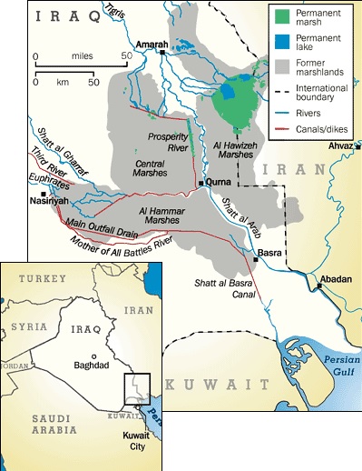
Figure 1. Iraq’s Southern marshes (Source: UNEP Iraq Project http:// marshlands-jp.unep.or.jp/)
21 of 33 wetlands in Iraq located in lower Mesopotamian marshes. Eight major wetland types in lower Mesopotamian marshes are identified as below (Scott, 1995);
- Permanent fresh water lakes with a rich submergent growth of aquatic vegetations and typically with marginal zone of floating aquatic vegetation.
- Permanent freshwater marshes dominated by tall stands of Phragmites, Typha and Cyperus.
- Rivers, streams, canals and irrigation channels, typically with little emergent vegetation and steep earth or muddy banks.
- Permanent ponds, mainly man-made irrigation ponds and duck-hunting ponds, typically with a pronounced drawdown in summer and little emergent vegetation.
- Seasonal freshwater marshes dominated by rushes and sedges, typically occurring as a broad belt around the edge of the permanent marshes.
- Seasonally flooded mudflats and semi-desertic steppe.
- Irrigated land and seasonally flooded arable land.
- Shallow, brackish to saline lagoons, mostly seasonal and often with extensive areas of Salicornia.
Permanent marshes, which are constantly wet, are covered with a species of common reed (Phragmites communis) called “gasab,” which grows to a height of over seven meters. Seasonal marshes, which dry up during the dry season from summer to autumn, are mainly covered with a species of common cattail (Typha angustata). A species of sedge (Scirpus brachyceras) is dominant in the temporary marshes, which are submerged only when the rivers overflow (Thesiger, 2009).
Geographically, the southern marshes consist of three major areas: the central marshes, the Hammar marshes, and the Al-Hawizeh marshes (Aoki et al., 2011; UNEP, 2006). Al-Hawizah marsh were designated as first globally importance wetland of Iraq in Ramsar Convention (Ramsar-1971) in 17 Oct. 2007. It is an integral part of the Mesopotamian marshlands complex centered at the confluence of the Tigris and Euphrates rivers. In spring, meltwater from the snows of the higher reaches of Iran and Turkey and Syria flows into the Tigris and Euphrates, causing the two rivers to periodically overflow. It is believed that this vast expanse of wetlands was formed by these repeated seasonal floods (Thesiger, 2009).
This area also abounds in indigenous species of animals and plants. It boasts an extremely high biodiversity and provides spawning grounds for fish and shrimps, the fishery resources of the Persian Gulf. In addition, the vegetation that spreads over the marshes and their surroundings provide permanent habitats for millions of birds, and surveys conducted in the 1970s confirmed the existence of over 80 species of birds. In particular, it is said that the southern marshes serve as an important relay point for migratory birds that travel from Western Siberia and Central Asia to Africa (Richardson et al., 2006). It is also claimed that Iraq’s southern marshes function as a filter for waste and pollutants that flow into the Tigris and Euphrates from their catchment areas, and that their existence helps protect the quality of the water in the Persian Gulf (Richardson and Hussain, 2006).
“Marsh Arabs” is the name the Westerners gave to the people who live around the southern marshes in Iraq. Of these inhabitants, the tribes who settle mainly in the marshes are locally called Ma’dān (meaning “dwellers in the plains (adan)” in Arabic) (Thesiger, 2009).
Traditional farming and fishery of the Marsh Arabs
The Marsh Arabs started to settle in Iraq’s southern marshes 5,000 years ago and have since lived there while being engaged in traditional agriculture and fisheries. They earn a living mainly by cultivating rice, wheat, and other grains as well as date palms and other fruit, raising cattle and buffalos, and catching fish and shellfish (Thesiger, 2009). Most of the Ma’dan are semi-nomadic, but some of them are settled in villages. Their settlements are located on the edges of the marshes, or stand on artificial floating islands that are regularly reinforced with reeds and mud (UNEP, 2001).
The main characteristic of the traditional lifestyle of the Marsh Arabs is the construction of houses and canoes using gasab, which grows on the shores of the rivers. Since the period before Christ, when the Sumerians lived, gasab has been an indispensable natural resource for the lives of Marsh Arabs. First, when they construct a house, they build a small island called a “Kibasha.” In autumn, when the water level is low, they surround a certain area of shallows with a long reed fence, fill the area inside the fence with layers of reed and rush, and solidify the foundation with mud picked up from the water. On this foundation, they set up arch-shaped pillars made from bundled reeds and then attach walls woven from reeds to the pillars to complete the house. Canoes called “Zaima,” which are made from hard reed stems, are used as a means of travel or transport in the wetlands. They make a living by raising many buffaloes as livestock and mainly drink the milk produced by them. Fresh plants are needed as feed for the buffaloes, and the new buds of reeds that grow abundantly in the marshes and their vicinity, as well as herbs growing along the waterside such as Polygonum senegalense, Jussiaea diffusa, Potamogeton lucens, and Cyprus rotundus are the main feed provided to the buffaloes.
In addition to hunting birds and wild boars that visit the wetland, the Marsh Arabs catch freshwater fish. Most of the Ma’dān spear the fish, but the members of a tribe called Berbera, who specialize in fishing, use cast nets and fixed shore nets to catch large amounts of fish and carry out poison fishing using toxic substances extracted from the Hindu datura (Datura stramonium) and other plants. In both cases, they formerly caught only the amount of fish they needed for selfsufficiency, but in recent years, they have been catching large amounts of fish to sell to other tribes.
In areas where seasonal or temporary marshes are located, some tribes cultivate such grains as wheat, barley, and rice. Called “Fallah,” which means “farmers,” they are distinct from the Ma dān, who live on buffalo breeding in the wetlands. Formerly, the Fallah cultivated rice and other crops only during the period when the water retreated from the flood plains, but in recent years, when it became possible to drain water from the marshes using power-driven pumps, an increasing number of Fallah tribes have started to cultivate the land permanently (Thesiger, 2009).
Challenges and Responses
During a period of over a century, more than 30 huge dams and other structures have been constructed along the Tigris and Euphrates in Iraq for such purposes as flood control, irrigation, water supply, and hydroelectric power generation, but since the 1970s, development and irrigation projects have been energetically carried out in the upper reaches of the Tigris and Euphrates outside Iraq, reducing the amount of water that flows into the southern marshes. Furthermore, starting in the 1990s, drainage, reclamation, canal construction, and other projects were implemented inside the marshes as well, decreasing their total water volume, and as a result it is estimated that 90% of the southern marshes had been lost by 2001 (UNEP, 2009; Aoki et al., 2011).
Moreover, the marshes were devastated by various projects such as the construction of dams and outflows that were implemented by the former Saddam Hussein administration up to 2003. These projects are said to have been intended not to develop the marshes but to intentionally destroy them because Shiite tribes, who were opposed to the Hussein administration, lived there and used them as a base for antigovernment operations (Aoki et al., 2011). Driven away from the marshes due to such environmental destruction as well as political repression, the Marsh Arabs dispersed and fled to other areas in Iraq or other countries. Not only the ecosystem of the marshes, but also the traditional lifestyle of the Shiites was substantially destroyed. At one time, the population of Marsh Arabs, which was once estimated to be 300,000-500,000, declined to as few as around 100,000.
Marsh Arabs who fled to other areas of Iraq or overseas when the Hussein administration collapsed in 2003 are gradually returning to the marshes and their vicinity. They themselves destroyed the outflows built under the Hussein regime and opened the gates that had limited the flow of water to the marshes. As a result, it is said that the marshes have been restored to around 30% of the previous level. Furthermore, the United Nations Environmental Programme (UNEP) and other international organizations, positioning the present condition of Iraq’s southern marshes as an important environmental and humanitarian issue, are implementing collaborative projects aimed at not only restoring the marshes to their original state, but also improving the overall living environment of the Marsh Arabs such as through revegetation, removal of the damage caused by saltwater, irrigation, and the improvement of water quality and sanitation. In 2006, thanks to the results of these projects, it is reported that about 50% of the marsh environment was being restored (UNEP, 2006).
As described above, due to the cooperation of people in Iraq and abroad in recent years, the total area and vegetation cover of the southern marshes are being substantially restored, but on the other hand, new problems are emerging. In some areas, water introduced again to restore the marshes has in turn raised the concentration of salt and pollutants, preventing the ecosystem from recovering. Those who are engaged in fisheries extensively practice poison fishing because it enables them to easily catch a large amount of fish at low cost, and the effects of water contamination on the health of humans and other forms of life are becoming a problem. In order to prevent such pollution, education of the fishermen is also considered necessary (UNEP, 2006). Moreover, wetlands in southern Iraq also suffered water shortage according to the significant human demand for water. In recent years, desertification due to regional drought and human-caused water shortages has claimed much of Iraq’s arable land in wetlands. There are also conflicts over water resources between Iraq and other countries such as Turkey, Syria, and Iran, whose territory covers the upper reaches of the Tigris and Euphrates. Not only this water shortage, but other problems such as the maintenance of public order in Iraq to carry out various projects, the allocation of water resources between farmers who have settled on the reclaimed land and the future of UNEP’s projects to restore the marshes are also left unresolved (UNEP, 2006; 2009).
References
Aoki, C.; Al-Lami, A.; Kugaprasatham, S. 2011. Lessons learned from environmental management of the Iraqi marshlands in the post-conflict period. Water International. 36(2), p.197-206.
Cole, J. 2005. “Marsh Arab rebellion: Grievance, mafias and militias in Iraq”. Proceeding of Wadie Jwaideh Memorial Lecture Series: Fourth Wadie Jwaideh Memorial Lecture by Department of Near Eastern Language and Cultures, Indiana University, Indiana, USA, 15 October 2005.
FAO. Marsh Arabs and Marshland Agriculture (Iraq). http://www.fao.org/nr/giahs/other-systems/other/asiapacific/ marsh-arabs-iraq/detailed-information4/en/ (accessed 2011-07-25)
Richardson, C.J. and Hussain, N.A. 2006. Restoring the Garden of Eden: An ecological assessment of the Marshes of Iraq. BioScience. 56(6), p.477-489.
Scott, D.A. (ed) 1995. A Directory of Wetlands in the Middle East. IUCN, Gland, Switzerland and IWRB, Slimbridge, U.K. 560pp.
Thesiger, W. 1964. The Marsh Arabs. Translated by Shirasu, H. 2009. Hakusuisha Publishing Co., Ltd, Tokyo, p.304.
UNEP. 2001. The Mesopotamian Marshlands: Demise of an Ecosystem, Division of Early Warning and Assessment. (Written by Partow, H.), UNEP, Kenya, 46p.
UNEP. 2006. The Marshes Restored: Environmental Management of Iraq’s Southern Marshes. http://marshlands-jp.unep.or.jp/. (accessed 2011-11- 15)
UNEP. 2009. “Support for Environmental Management of the Iraqi Marshlands 2004-2009”. http://www.unwater.org/wwd10/downloads/Support_ for_EnvMng_of_IraqiMarshlands_2004-9.pdf. (accessed 2011-11-15)
UNEP “Iraq Project”. http://marshlands-jp.unep.or.jp/. (accessed 2011-07- 25)