How Nature-Based Solutions Can Help Reduce Flood Risks
16.11.2023
SUBMITTING ORGANIZATION
Asian Development Bank (ADB)
OTHER CONTRIBUTING ORGANIZATIONS
Deltares
DATE OF SUBMISSION
22/08/2023
REGION
Asia
COUNTRY
Philippines
KEYWORDS
Natural River Management, Nature-based Solutions, Room for the River
AUTHORS and AFFILIATIONS
Isao Endo (ADB)
Junko Sagara (ADB)
Bregje van Wesenbeeck (Deltares)
WEB LINKS
Summary Sheet
The summary sheet for this case study is available here.
BACKGROUND
The Infrastructure Preparation and Innovation Facility (IPIF), in collaboration with the transaction technical assistance for preparing the Integrated Flood Risk Management Sector Project, is helping the Government of the Philippines prepare flood risk management (FRM) projects in six river basins in Luzon, Visayas, and Mindanao. This technical assistance (TA) loan is supporting the government to develop comprehensive basin-level flood risk management master plans with short, medium, and long-term strategies; and feasibility studies and detailed engineering designs of priority FRM infrastructure.
The regional TA on Protecting and Investing in Natural Capital in Asia and the Pacific provided expertise in integrating nature-based solutions (NbS) investment options into the proposed FRM master plans for the Abra, Buayan–Malungon, and Tagum–Libuganon river basins. The support included developing methodologies to blend NbS into the FRM master plans through the natural river management (NRM) approach (ADB 2021).
The NRM approach leverages the intrinsic abilities of natural river systems to deliver climate resilience at a lower cost while minimizing negative environmental and social impacts. It is iterative, science-based, and follows the principles of participatory water resources management. It strives to respect the natural dynamics and flow of freshwater, sediment and nutrients, and peoples’ dependencies on these at the basin. In addition, the regional TA applied an NbS selection process using multicriteria analysis (MCA)1 and cost–benefit analysis (CBA).
This brief shares how the regional TA identified NbS options for the FRM master plans using the NRM approach. The river basins used as NbS pilot areas could serve as models for potential replication and upscaling in other river basins in the Philippines and as good practice for NbS practitioners.
1. Multicriteria Analysis: a complimentary approach to cost–benefit analysis (CBA). It is a form of appraisal that, in addition to monetary impacts, measures variable such as material costs, time savings and project sustainability as well as the social and environmental impacts that may be quantified but not so easily valued (betterevaluation.org).
INTRODUCTION
Due to its geographical location, the Philippines is among the countries most vulnerable to disasters triggered by natural hazards and flooding. The Global Climate Risk Index 2021 ranked the country as the fourth most vulnerable to extreme weather events such as tropical cyclones and flash floods (Eckstein et al. 2021). Rapid population growth and urbanization of low-lying areas will further increase flood risk and endanger unprotected communities. Many informal settlements in flood-prone areas are among the most vulnerable to
natural hazards.
Communities need to prepare for more severe and more frequent river and urban flooding in the future with the onslaught of more severe cyclones and heavy rainfall due to climate change. The negative impacts on livelihoods, agricultural yield, and human health due to vulnerability to these natural
hazards are significant. If not managed properly, riverine disasters may derail the country’s socioeconomic progress with severe long-term impacts.
To address this threat, the Government of the Philippines has ramped up its spending on hard infrastructure with a budget of $180 billion under the government’s “Build, Build, Build” program until 2022. More than 5% of the gross domestic product has been set aside to build roads, bridges, and flood
mitigation structures and drainage systems among others in the next decade (ADB 2017). The government will build a large share of these projects in rivers where they will have an enormous impact on managing sustainably natural resources, and improving biodiversity and ecosystems’ health.
In the face of multiplying climate-related environmental threats and potential exposure to natural hazards, hard (gray) infrastructure alone may no longer be enough to build climate resilience. Gray infrastructure will continue to be critical to mitigate flood risk, especially in dense urban areas with limited
space, but it may not provide the integrated and higher levels of flood protection needed in the future with more severe weather events. Meanwhile, investing in NbS with green infrastructure and socially inclusive concepts have increasingly been studied, implemented, and accepted as effective
measures around the world.
Green infrastructure used as an ecosystem-based adaptation approach protects people against floods and impacts from extreme weather and addresses climate change and biodiversity threats. Green infrastructure often is in the form of functionally designed green spaces that serve the hydrological
functions, among other ecosystem services, and they also can be enjoyed for recreation, which is especially beneficial in and near urban areas.
NbS create most benefits when applied under a comprehensive NRM approach that in turn should be part of a broader integrated water resources management system. It can increase the resilience of communities and economies against floods and erosion. NRM is a way to harness the functions of natural river systems to nurture climate resilience at a lower cost. At the same time, it also aims to achieve positive environmental and social impacts (ADB 2021). Ideally, NbS and its green infrastructure are systemically integrated with existing and improved gray infrastructure, and then flood protection in urban and rural areas will be most effective. NbS together with conventional gray infrastructure and nonstructural measures are essential elements not only in harnessing vital ecosystem functions, but also in decreasing the vulnerability to natural hazards of people living in river basins or along coasts.
CASE STUDY OUTLINE
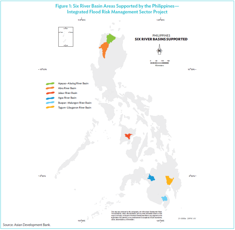
The IPIF is supporting preparation of integrated flood risk management projects for reducing and mitigating flood risks in six major river basins in the country: Apayao–Abulog and Abra in Luzon, Jalaur in Visayas, and Agus, Buayan–Malungon, and Tagum–Libuganon in Mindanao (Figure 1). Under Output 2 of the Infrastructure Preparation and Innovation Facility (IPIF), the DPWH has prepared basin-wide flood risk management master plans including short to medium-term and long-term investment plans to deal with future flood risk in the six river basins with the support from the Protecting and Investing in Natural Capital in Asia and the Pacific to promote NbS in combination with hard-engineering solutions. There is a great opportunity to add and integrate NbS in these plans to add value and minimize the negative environmental and social impacts, increase flood protection effectiveness, and create other co-benefits and positive outcomes.
NATURE-BASED SOLUTIONS FOR FLOOD RISK MANAGEMENT
Availability of Guidelines
There are existing guidelines for river basin planning and integration of NbS. The DPWH of the Philippines have adopted the Integrated Water Resources Management (IWRM) guidelines (World Bank 2016). Others include the Guidelines for Mainstreaming Natural River Management in ADB Water Sector Investments (ADB 2021). These publications help ADB project teams and professionals who work on project design and implementation to systematically integrate NbS and NRM approaches into water sector investments.
The main challenge of integrating NbS and NRM into ADB investments is time constraints during project preparation and lack of available data for a meaningful assessment. NbS are not always part of the requirements and general practices. In fact, these solutions are usually not considered even in projects compliant with ADB environmental safeguards.
Recognizing this issue, the regional TA on Protecting and Investing in Natural Capital in Asia and the Pacific supported the project using the stepwise NRM approach. This enabled integration of NbS in flood master plans and feasibility studies in three pilot river basins. It also opened the possibility of replicating and upscaling the good practice in other river basins. The operation support also analyzed the river basin systems to better understand the main risks. To do this, socioeconomic analysis was done to identify the population dependent on river functions for their livelihood, such as fishers and subsistence farmers, and the economic sectors dependent on river functions, such as inland waterway transport, tourism, and energy production. The next steps included identifying the population and economic sectors exposed to river-related threats (erosion, flooding, water pollution) and the vulnerability of the population and economic sectors to these threats.
Types of Nature-Based Solutions in River Systems
The more severe and frequent extreme weather events due to climate change impacts have shown the limitations and inability of existing hard and/or gray infrastructure to manage floods effectively. The green approach and NbS has increasingly proven to be an effective contributor to flood risk management.
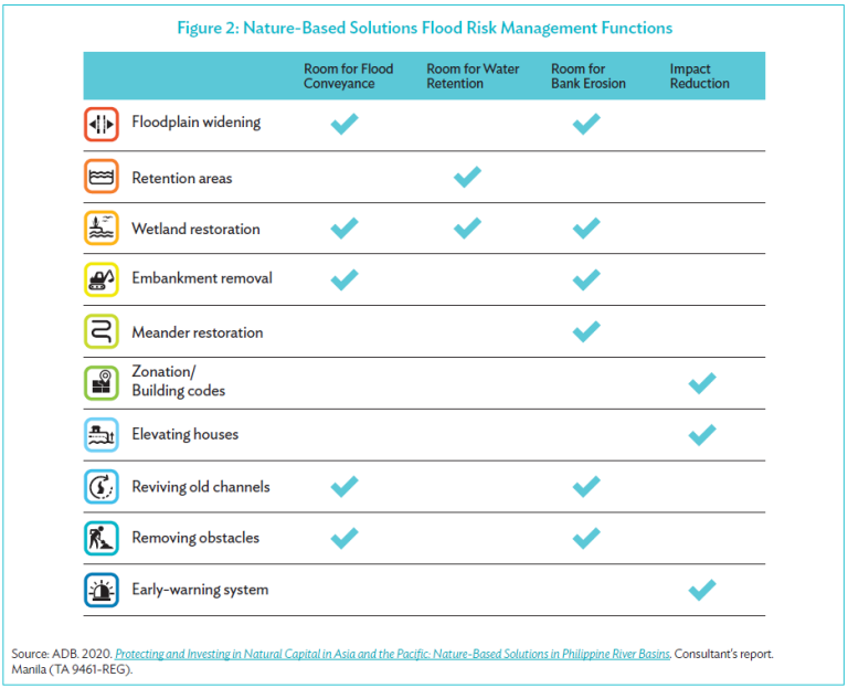
In river systems, NbS are green and inclusive interventions that respect river dynamics and ecosystem functions. These interventions are grouped by function with related actions (Figure 2):
- Flood conveyance solutions increase the river’s capacity to contain high discharge (heavy rainfall) events. The area’s drainage is improved to enable quick release and flow of stormwater downstream before it accumulates and floods. At the same time, it also minimizes the risk of flash floods downstream.
- Water retention and detention are solutions that smoothen the peaks of high discharge (heavy rainfall) events. These include various forms of temporary stormwater storage that may be slowly released back into the river network.
- Bank erosion control solutions reduce the sediment carrying capacity of the river by reducing flow.
- Flood impact reduction are solutions that may be nonstructural and structural. The first includes implementation of early warning systems and flood zoning. The latter can be based on gray infrastructure like walls and dikes and/or green infrastructure measures, such as green embankments and river greenways. Ideally, green solutions are maximized, and gray and green solutions are systemically integrated. These reduce the exposure of communties and assets to natural hazards.
NATURAL RIVER MANAGEMENT APPROACH
An integrated flood risk management approach that includes and/or applies NbS helps reduce flood risk considering the whole river basin while contributing to other environmental and social benefits. The NRM stepwise approach (Figure 3) is useful in quickly assessing NbS interventions. This process sets comprehensive and multiple objectives and the conduct of a multicriteria analysis, with potential inclusion of more detailed climate risk and vulnerability assessments. These steps help stakeholders thoroughly understand the river dynamics, the socioeconomic context, and the institutional system in the whole river system, including the upstream and
downstream areas.
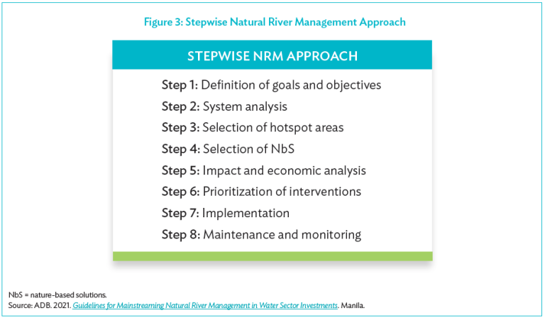
It is important to consider the entire river basin and, as the next key step, to choose critical areas and hotspots through the NRM approach based on the river-basin wide risk assessment. The sites can be identified by mapping layers of areas with water shortages, flood hazard and inundation maps, erosion
problems, population and urban areas, public infrastructure and assets, economic activity, and important ecosystems. Project teams must visit the hotspots and carry out a localized risk assessment, inclusive of climate change risk and vulnerability assessment.
While proposing solutions to solving problems in an identified hotspot is a priority, new interventions do not need be carried out within this area (Figure 4) as the entire river basin is being considered. The first step is to assess all possible ways to retard flood peaks and store flood waters upstream of the
hotspot. Taking interventions upstream creates the potential for more space to store flood waters. It also helps to avoid relocation and/or emergency evacuation of people or building embankments and flood walls, which can aggravate flooding downstream. In places where the river meanders and is most dynamic, it can be effective to retain the meandering. At the same time, it may also be worthwhile to take interventions that will further increase flood conveyance, and delay and retain flood waters. These keep flood peaks, flash floods, and sediment runoff at bay, and are also effective against droughts.
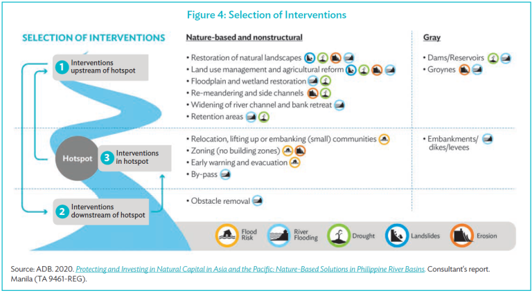
When it is not possible to apply NbS upstream due to a lack of space, land-use and ownership constraints; insufficient contribution to the reduction of flood risk downstream; or a big change in the river’s hydraulic conditions, explore
possibilities at and further downstream of the hotspot area. Potential downstream and hotspot interventions include removal of obstacles, relocation of people, zoning, or building embankments. The early warning system is an exception since this is usually a no-regret and nonstructural intervention.
As such, it could be considered at the start when choosing appropriate NbS.
The suite of deliberate basin-wide solutions can include both gray and nature-based measures. Once a portfolio of solutions has been developed, the impact and benefits of each solution for the entire basin should be assessed to see if they strengthen or negatively affect each other.
The multicriteria analysis (MCA) and cost–benefit analysis (CBA) are tools that can help project teams make well-informed decisions, prioritize investment plans and guide phased implementation. In the master plan phase, these can
be used in choosing a strategy that will be elaborated in the feasibility phase. The tools are also valuable in identifying which measures to prioritize. It is important to consider the full range of impacts of each measure and avoid making decisions that have unexpected or unaccounted impacts.
For example, if a decision is only based on a limited number of indicators, such as reduction in expected annual damage and costs, solutions that have a lower reduction in damage, but a positive impact on health and biodiversity will be excluded from the analysis. Hence, it is advantageous to present the results from using both tools. The process will help decision makers compare all interventions in a comprehensive way. Additionally, the monetized effects will also be included in the MCA and compared with other assessment criteria.
PROPOSED NATURE-BASED SOLUTIONS INTERVENTIONS
The Nature-based Solutions in Philippine River Basins report discussed the three basins that have the potential to host flagship NbS projects. It aimed to showcase that NbS can be done successfully. It is important to note that the recommended NbS for the three case study areas and/or river basins may
require an in-depth feasibility study and participatory planning for effective implementation.
Analysis and Risk Assessment
A system analysis was conducted on six rivers to get an overview of the environmental and socioeconomic characteristics and the key challenges of each river basin. The concept of “Room for the River” was taken as a strategy for comparison. This means that the analysis considered how much green space can serve as natural regulation area. It also examined the green area a river has to adjust on the sides along the river course during extreme weather events, such as heavy and long rainfall events and long, dry periods. If a river has enough green space, there will be low interference with natural river dynamics and the river can simply overflow onto the green areas that can serve as floodplains during heavy rainfalls. A risk-based approach was advocated using hard interventions in the form of gray infrastructure in higher-density urban areas with vital assets or many people. This ensured that the funding was allocated to areas that would benefit the most people. An in-depth analysis was carried out in three river basins based on the risks.
Selection of River Basins for In-Depth Case Studies
The three selected river basins—Abra, Buayan–Malungon, and Tagum–Libuganon river basins—all have high-risk hotspot locations and relatively large cities with around 300,000 inhabitants in the downstream area close to the coast. Multiple hazards threaten these cities, such as flooding from the river, from the coast, and by stormwater runoff. In the midsections of these rivers, smaller flood risk is expected, but there is potential to restore meanders, have double embankments, retain flood waters, and improve some of the old projects by taking an NRM approach in these rivers. The rivers differ largely from each other in climate, natural state, and discharge capacities.
Identification of Key Challenges and Hotspots
Hotspot areas were identified based on risk assessment. Risk is typically a combination of hazard (intensity and probability), exposure (people and assets) and vulnerability (susceptibility of assets and people to the hazard). To select the hotspots, map layers of areas with water shortages, flood hazard maps, erosion problems (for instance based on Aqua-monitor), population, economic activity; and important ecosystems can be overlaid. Areas with the highest exposure to natural hazards can be selected as hotspots. Preferably, the identified hotspots should be visited to assess the vulnerability of the population to natural hazards. This will enable project teams to do a more localized risk assessment including damage curves for average and extreme events. Then, areas with the most vulnerable population to natural hazards could be identified as main hotspots.
Proposed Types of Nature-Based Solutions
Room for the River: Improving Flood Conveyance and Reducing Coastal Flooding Impacts
Buayan–Malungon River basin: This river basin is located in two regions in Mindanao. It was chosen as one of the river basins that could serve as an example for NbS implementation. It covers the provinces of Davao del Sur and Davao Occidental in Region 11, and Sarangani and South Cotabato in Region 12. The area includes 8 municipalities and 75 barangays. Most of the land is cultivated area. The river’s basin area is mostly covered by perennial crops and grasslands. The river basin has 5.6% forest area and the accessibility to the river basin is good.
There are at least 299,679 inhabitants in the river basin, with Sarangani province having the largest population at 165,670 (55.3%), followed by the province of South Cotabato with 72,391 (24.2%), and Davao del Sur with 61,618 (20.6%) (Philippine Statistics Authority [PSA] 2015). It is expected to increase to 2.1 million by 2050 (IPIF Output 2 Consultant 2019). At the regional level, poverty incidence has declined from 18% in 2015 to 13.9% in 2018 for Region 11, and 31.2% in 2015 to 22.4% in 2018 for Region 12 (PSA 2020). Among the municipalities within the Buayan–Malungon River basin, poverty incidence is highest in the provinces of Sarangani (36.1%), followed by Davao Occidental (31.9%).
Agriculture is the main livelihood, but poor water supply has forced inhabitants to other sources of income such as charcoal making2 and logging of trees.3 The sediments deposited into the river amass in the middle and lower basins with low slopes and strong river meandering where it attracts uncontrolled quarrying activities. The disturbance from this activity has an enormous impact on the river geomorphology.
Environmental challenge: The aim of the assignment was flood damage reduction—one of the biggest issues in the basin. The current expected annual flood damage in the basin is estimated at ₱1.1 billion ($22.6 million) a year in the Philippines. It poses a serious risk to about 39,000 individuals (IPIF Output 2 Consultant 2019). Other natural hazards common in this basin are droughts, earthquakes, and landslides. The master plan also mentioned other risks including storm surges; coastal erosion; pollution from sewage, solid waste, and agricultural pesticides; and health issues related to stagnant waters.
Hotspot areas in the basin were identified based on the problem and risk assessment. The flattest and most populated part of the basin is the downstream area. It was singled out as the most at risk based on the combination of such hazards as river and coastal flooding, waterlogging, and soil erosion. The floods are concentrated in the river mouth and the confluence of the Buayan and Maribulan rivers. High discharges can cause floods lasting up to 6 hours in Barangay Buayan and Barangay Baluntay. Existing infrastructure such as the Old Buayan Bridge downstream and new Buayan bridge upstream further worsens flooding.
Proposed nature-based solutions on issues in the basin: The Buayan–Malungon river basin flood risk management master plan contains two strategies for the downstream area. Both are a combination of gray, nature-based, and nonstructural measures. The strategies comprise demolition of the Old Buayan bridge and of a dike, construction of jetties on each side of the Buayan river, drainage improvement, and mangroves planting and/or restoration. The unique features of strategy 1 include the construction of a natural bypass and the protection of barangays which are most at risk. Strategy 2 resettles these communities and elevates the road. The aim is to provide additional decision-making information to support strategy selection.
Both have elements of a Room for the River approach. For example, demolishing the dikes and bridges will create more room, whereas the permeabilization of the new Buayan bridge will reduce the number of obstacles in the river. The bypass reduces the pressure on the confluence of the Buayan and Maribulan rivers and will reduce flooding in that area. Another type of NbS is the restoration of mangrove forests. This aims to reduce the impact of coastal flooding. Aside of the proposed NbS, both strategies include gray infrastructural measures, such as the construction of dikes and jetties.
To determine the best strategy, a multicriteria analysis was conducted. The criteria included costs, reduction in expected annual damage,4 and nonmonetized indicators such as protected population and social resettlement acceptability (Figure 5).
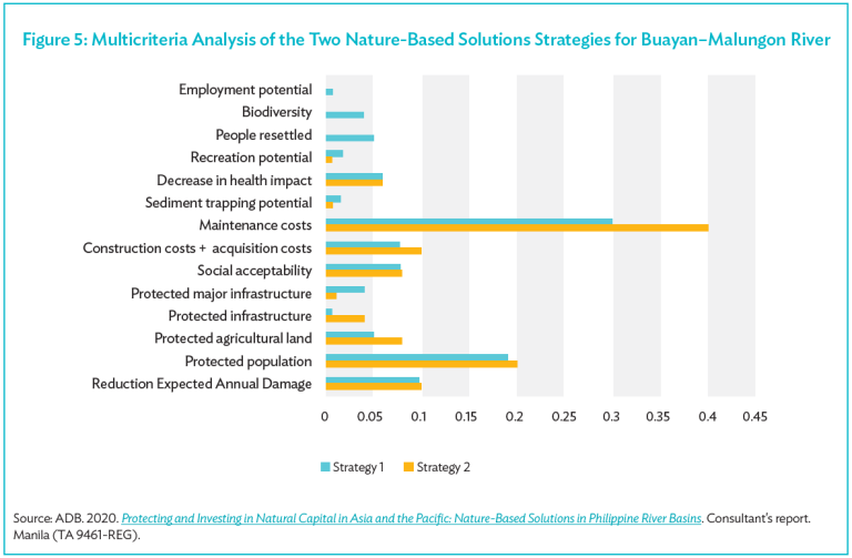
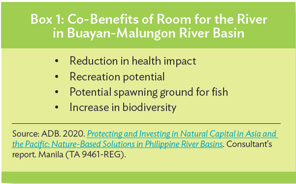
The more elaborate analysis for the Buayan–Malungon showed that considering the co-benefits of solutions provides better decision-support information (Box 1). The MCA executed there showed that a more comprehensive list of indicators representing multiple co-benefits could lead to different outcomes.
The final scores were determined by using a simple linear additive evaluation model with the maximum known score as reference point. Not all suggested indicators could be included (e.g., food security), and the weights and impacts of the additional indicators are mainly based on expert judgment. The overview cannot be considered as a full MCA; however, it provides an indication of the impact of the two strategies when additional indicators are considered. According to this analysis, strategy 1 is slightly preferred above strategy 2, mainly due to the impact on biodiversity and the absence of resettlement.
The expected impact of the strategies does not seem to be significantly different. This shows the importance of stakeholder consultation and exploration of possibilities to design the strategies in such a way to provide additional benefits. In this case, stakeholder consultations with two affected communities in Barangays Baluntay and Maribulan consisting of 173 households showed that they were open to being resettled (IPIF Output 2 Consultant 2019). Their final decision regarding the resettlement depends on the new location and services that will be provided there.
Expected impacts: Both strategies proposed in the downstream area of Buayan–Malungon river basin include the room for the river approach combined with gray infrastructure. The strategies reduce flood damages and waterborne diseases in the downstream part of the basin. These are expected to have positive effects on livelihoods. Furthermore, the strategies can
increase biodiversity and reduce ecosystem degradation when designed in a natural way.
Additional research is still required on the effectiveness, benefits, and impacts of the proposed measures in the feasibility phase. For example, the jetties might impact the mangroves. This will reduce the flood protection services of
the mangroves. It is also recommended to further explore the impact of resettlement of households, specifically focusing on the service level of the current and new location. In the feasibility stage, there should be room to either include or exclude measures from the strategy based on the effects and
societal benefits. Furthermore, less attention was paid to the responses of local communities to the proposed measures. For example, local communities can use newly planted mangroves for logging, grazing cows, or other ways that will not let the mangroves thrive. In terms of resettlement, more intensive stakeholder involvement and consultations are needed to come up with interventions that benefit all people that live in these areas. It is important to better understand the behavior of local communities to carry out the selected
strategy successfully.
Wetland restoration to increase drainage capacity while improving water quality and biodiversity
Tagum–Libuganon River basin: This river basin is in Southern Mindanao, extending over Region 11, Region 13, and four provinces: Davao del Norte, Davao del Sur, Compostela Valley, and Agusan del Sur. Davao del Norte province lies almost entirely in the basin while other provinces have only a minor part of their area in it. The catchment area covers 3,119 km2 based on the most recent assessment of its administrative authority. This river basin is in turn part of the vast Agusan Valley which is hedged between two structural north–south trending mountain ranges—the Diwata on the east and the
Mindanao Central Cordillera on the west. The forest area is estimated at 43% and the accessibility is rated as average.
This valley measures 180 kilometers (km) from North to South and varies from 32 km to 48 km in width. The lower basin has flat terrain with good soil quality for crop production as well as a presence of nonmetallic minerals such as gravel, sand, and limestone. The land cover of the river basin is devoted to
perennial crops.
There are around 824,155 inhabitants (PSA 2015) and by 2050, it is estimated to increase to 1,443,063. In 2018, the municipality with the lowest poverty incidence was Davao del Sur, with 8.1% (where Davao City is located), then Davao del Norte with 10.3%, followed by Compostela Valley with 18.6%, and Agusan del Sur with the highest poverty incidence: 18.9%.
The main sources of livelihood in the basin are aquaculture, agriculture (banana, rice), agroforestry, trading, and quarrying activities attracted by the rich material deposits. Though agriculture represents 63% of the income sources at the scale of Davao del Norte, industry is well developed in Tagum City and Panabo City with about 50% (Tagum City) and 40% (Panabo City) of the income sources of the local government (data calendar year 2013). Tagum City, Panabo City, and Santo Tomas are the major growth centers, while the Island Garden City of Samal, Kapalong, and Carmen are considered emerging
growth centers.
Environmental challenge: The Tagum–Libuganon river basin’s existing infrastructure, roads, and narrow culverts has aggravated flood problems for the municipality of Carmen. Regular flooding is frequently reported in the area, especially in barangays Tuganay, Alejal, and Ising. Other factors contribute
to the flood hazard, such as improper land use, change in river morphology from natural factors, or man-induced activities such as quarrying, and the presence of structures and communities in flood-prone areas. These include current solid waste management practices that block river drainage channels.
Furthermore, the basin lies in a seismically active zone. Fault lines are present in the upper basin and landslides are frequent in the upper basin with steep slopes and along the Compostela Valley, which lies east of the basin. The expected annual damage is ₱1.947 billion ($39 million).
Flood modeling confirms these observations and historic analysis show that the construction of two major roads worsened flood events by funneling water toward these specific neighborhoods and by blocking the Ising river. As a result, the Ising river silted rapidly. Although the Tuganay river is embanked,
these embankments are breached or overtopped during flood events with higher return periods, and the Tuganay spills into the Ising wetland area.
Proposed nature-based solutions on issues in the basin: The suite of solutions proposed is an integrated system approach. It includes the building bridges and culverts in the road to accommodate peak runoff during 100-year events,
comprehensive land use planning, restoring the Ising wetland, and creating a green river-like connection between the Tuganay and Ising river. The latter can improve natural quality of Ising river and Ising wetland, which is an area dominated by irrigated rice and banana plantations.
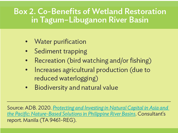
Expected impacts: A revitalized Ising wetland offers diverse and vital ecosystem goods and services for the Ising river and adjacent ecosystems (Box 2). These include water purification, sediment trapping, recreation, and enhancing biodiversity and natural values. Wetlands with high biodiversity provide natural water treatment services. It filters the runoff such as sediment,
excess nutrients, and chemicals that flow off the land before it reaches open water. The Ising wetland can also act as a buffer for excess rain. By soaking up excess water like a sponge, it can potentially reduce flooding in nearby areas.
There would also be a big decrease in waterlogging, river flooding, and erosion issues with land use planning, construction of bridges and culverts, reviving the Ising river, and wetland revival. These interventions will increase the system’s drainage capacity and add retention areas that can reduce flood peaks. The decrease in waterlogging will reduce damage to houses and
to agricultural yield. Furthermore, recreation opportunities will increase as the biodiversity improves. Moving forward, intensive stakeholder engagement would be critical, and it is equally important that communities, agencies, and organizations in the river basin play an active role in carrying out the proposed NbS. A series of public consultations and focus group discussions were held in
the 15 project-affected areas and, in general, supported the intention of the Department of Public Works and Highways to develop a Flood Risk Management Master Plan and Feasibility Studies for the river basin. The participants to the public consultations acknowledged that using the participatory process takes longer than what they are used to. Hence, it is
critical to align to the timelines of the offices and organizations involved. They also signified their desire to be involved from planning to project implementation.
During the public consultations, the social acceptability of the projects was gauged based on the social and technical issues raised as well as public attitude. As is in the case of most river widening projects, owners of affected lands for right-of-way are less receptive of the measures, except those who suffer major losses due to flood. Despite this, the people acknowledged the
need for flood mitigation. Given this scenario, the government needs to coordinate plans and activities among its agencies, both vertically (national, regional, provincial, local) and horizontally (among different sectors), given their various mandates. In addition, the participation of key players from the
private sector as well as from nongovernment organizations will enhance the master plan for the river basin.
Smart Quarrying: Reducing Riverbank Erosion and Flooding while Promoting Livelihood Opportunities
Abra River basin: This basin extends over Region 1 and the Cordillera Administrative Region (CAR) in Northern Luzon and covers four provinces: Ilocos Sur in Region 1, and Abra, Benguet, and Mountain Province in CAR. The Abra river flows from CAR through a gap in the mountain ridge to the coast of the Ilocos Region. The river basin has an area of about 5,125 km2.
The topography of the northern, eastern, and southern portions of the basin is rugged and mountainous. Elevations rise to 1,500 meters above sea level (m asl), and flat terrain make up only an estimated 10% of the watershed. Most of the Abra River Basin is covered by trees in the form of brush and/or shrubs (34%) and open forests (29%), while grasslands occupy the third position with about 14% coverage. Agricultural lands, found in the valleys and on the plateaus, represent 10% of the watershed surface, compared to the area covered by closed forests which is at 8%. The forest cover in Abra province in 2018 was 258,479 hectares (ha).
Based on the 2015 census, the population is 487,651 (PSA 2015). The population is expected to reach 680,000 inhabitants in 2050. The 2018 poverty incidence rate is 17.1% in the Mountain Province, 14.7% in Abra, 5.5%in Ilocos Sur, and 4.2% in Benguet (PSA 2020). The area dedicated to agriculture on the river basin is very limited (about 5% of total area), but is important to the community’s livelihood. The major activity in the upper basin is forestry while in the delta area, the focus is on fishery and tourism. Some livestock and poultry farms are found, and riverbed quarrying is very active all along the river, such as sand, gravel, and small boulders extraction for civil works.
Environmental challenge: The natural hazards that affect the basin are soil erosion, floods, landslides, typhoons, and drought. Overbank flooding affects 7,700 inhabitants and 5,570 ha of agricultural lands in the midstream section of Abra river. Barangay Bangued is the second largest settlement in the basin, and it is a hotspot for flooding, which affects residents and agricultural lands. Bank erosion is also a genuine problem because of the river’s significant lateral displacement and constantly evolving braided channels. The expected annual damage is ₱344 million (about $6.89 million). Agricultural lands and vital bridges on the flat flood plain at the confluence of the Tineg and Abra rivers are vulnerable to wandering channels and scouring and/or bed incision. Quarrying is also a frequent problem in Abra river as it artificially changes the geomorphology of the basin. As a result, flooding and erosion hazards may worsen. Earlier investments focused on the construction of dikes and revetments to protect infrastructure and agricultural areas.
Proposed nature-based solutions on issues in the basin: Interventions should aim to give room for the river to accommodate natural river meandering, braiding, and channel movement; and to allow the river to overflow onto the floodplains during peak flows. It is possible to reduce the vulnerability of assets to natural hazards (either existing or resulting from creating more room for the river) by implementing building codes and resettling vulnerable communities. Allowing the river to naturally meander slows down the river flow and reduces the river’s carrying capacity. This may help minimize soil erosion risks of settlements and assets directly downstream.
For Abra, quarrying can be used to facilitate the desired morphological river development through smart quarrying practices. This involves quarrying at strategic areas by either the private sector, the government, or local communities. It can be done at targeted areas to divert the river channels away from vulnerable assets. Investing in temporary roads (e.g., bailey bridges) in the riverbed may also help in moving from uncontrolled to smart quarrying. Depositing sediment at other locations can help the river’s morphology improve in an adaptive manner.
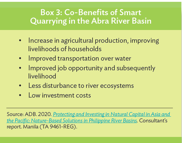
Expected impacts: A smart quarrying strategy can reduce overbank flooding and especially lateral bank erosion in the basin. This is expected to positively affect people’s livelihood and produce co-benefits (Box 3). Deforestation might decrease when the local community plays an active role in quarrying the riverbed. They would not need to do as much slash-and-burn vegetation to sustain their way of life.
Quarrying activities, however, should be accompanied by a monitoring program. A long-term monitoring program on water levels will shed light on the amount of quarried sediment through specific-gauge analysis and hydrological changes. Other aspects that could be monitored include riverbed topography and water levels at gauge stations along with the annual calibration of their stage-discharge relationships.
2. Kaingin refers to slash-and-burn cultivation by many upland farmers (FAO, 2003). It is also referred to as swidden agriculture and it had been practiced for centuries in the Philippines by indigenous farmers roaming mountainous areas. The technique involves clearing the land by slashing and burning underbrush and trees and plowing the ashes under for fertilizer.
3. Section 68 of Presidential Decree 705 or the Revised Forestry Code of the Philippines states that “any person who shall cut, gather, collect, or remove timber or other forest products from any forest land, or timber from alienable and disposable public lands, or from private lands, without any authority under a license agreement, lease, license or permit, shall be guilty of qualified theft as defined and punished under Articles 309 and 310 of the Revised Penal Code.”
4. Expected annual damage includes damage to houses and household content as well as damage due to outages of businesses and industries.
LESSONS LEARNED AND RECOMMENDATIONS
Every river basin is different. This also means that for the reduction of flood and erosion risk in river basins there is no one-size-fits-all example available. As such, risk assessment and consultation of local stakeholders, as described in the NRM approach, are required to understand the main problems and select the most promising NbS. Based on the application of the NRM approach in the case study areas, the following lessons have been learned:
- Many flood or sediment-related problems downstream are the result of inadequate river management identified in the upstream sections of rivers. For example, these consist of deforestation and land use practices that increase the probability of landslides. Therefore, for all upstream areas, reforesting and adapting land-use management is considered the most effective management strategy. There is a need to better facilitate, reinforce and control these strategies.
- In the midstream, most rivers experience the adverse impacts from heavy quarrying. This can potentially lead to bed incision, erosion of riverbanks, and lowering of groundwater tables. Limiting quarrying activities and the installation of quarrying facilities owned by local municipalities are strongly advised. Quarrying activities should be accompanied with a monitoring program that focus on maintaining morphological quality of the river.
- Several rivers show signs of straightening and channeling in the midstream sections. To reduce downstream flood peaks, it is strongly recommended to maintain the length of the river flow path in the midstream sections, as opposed to straightening. It is also important to maintain surface roughness to slow overland flow.
- In the midstream and downstream sections, there are examples of narrow bridges that block river flow during peak discharges. These cause flooding upstream of the bridge. It is recommended to extend the height and width of several bridges to avoid blockage of the river and collapsing bridges.
- In many river basins, cities and urban development with population pressure and reduced space for the rivers are highest in the downstream sections. Flat coastal plains and increasing impacts from sea-level rise hinder river discharge and can result in combined events of river flooding and coastal flooding and urban flooding with high water levels, high discharges, and high rainfall that result in severe flooding of cities and urban areas. This is best mitigated through improved gray infrastructure and integration with green infrastructure that together can very effectively
reduce risk of flooding. - River mouths are often mobile, and management of mobile river mouths in densely populated areas poses a major challenge. In several areas, it may be possible to fixate the river mouth at one side and leave space for floodwaters, flood plains, and mangroves on the other side.
- Living too close to the coast makes coastal communities vulnerable to natural hazards, but is often linked to livelihood practices such as fisheries. Several good practices are available to increase the resilience of coastal communities. Stakeholder involvement and consultation is a key element here to come up with interventions that benefit all people who live in these areas.
CONCLUSIONS
Including nature and NbS into management of rivers and coasts is a field that has garnered global attention. However, the practice is still relatively uncommon in project design and implementation due to (i) the lack of generic guidelines and rules, (ii) a small evidence base, and (iii) the perception of gray infrastructure as a main form of infrastructure and skepticism against green
infrastructure as being effective and lasting, and (iv) the minimal inclusion of co-benefits in the analysis, among others. There are also institutional and legislative constraints that hamper NRM.
For example, agencies have their own mandates and evaluation metrics that often focus on a single function and on smaller time and spatial scales. Over the long term, fully integrating ecosystems into infrastructure planning requires both a change in mindset and civil engineering education, and changing the
method of project economic benefit assessment. Finally, people’s attitude toward natural hazards must also include adaptation measures with structural measures.
REFERENCES
Asian Development Bank (ADB). 2017. Meeting Asia’s Infrastructure Needs. Manila.
- 2020. Protecting and Investing in Natural Capital in Asia and the Pacific: Nature-Based Solutions in Philippine River Basins.
Consultant’s report. Manila (TA 9461-REG). - 2021. Guidelines for Mainstreaming Natural River Management in Water Sector Investments. Manila. (TA 9461-REG).
- Philippines: Infrastructure Preparation and Innovation Facility (Sovereign Project | 50288-001).
https://www.adb.org/projects/50288-001/main - Philippines: Integrated Flood Risk Management Sector Project (Sovereign Project | 51294-002).
https://www.adb.org/projects/51294-002/main. - Regional: Protecting and Investing in Natural Capital in Asia and the Pacific (Sovereign Project | 50159-001). https://www.adb.org/projects/50159-001/main
Better Evaluation. Multi-Criteria Analysis. https://www.betterevaluation.org/en/evaluation-options/multicriteria_analysis
D. Eckstein, V. Künzel, and L. Schäfer. 2021. Global Climate Risk Index 2021: Who Suffers Most from Extreme Weather Events? Weather- Related Loss Events in 2019 and 2000–2019. Germanwatch e. V.
Deltares. Aqua Monitor. https://www.deltares.nl/en/software/aqua-monitor/
Infrastructure Preparation and Innovation Facility (IPIF) Output 2 Consultants. 2019. Masterplans Apayao–Abulug river basin, Abra
river basin, Agus river basin, Buayan–Malungon river basin, Jalaur river basin, Tagum–Libuganon river basin: Executive summaries and
background documents. Report prepared for the Department of Public Works and Highways and ADB. Unpublished.
Philippine Statistics Authority. 2020. Updated 2015 and 2018 Full Year Official Poverty Statistics. https://psa.gov.ph/poverty-pressreleases/
nid/162559.
World Bank. 2016. Philippines: Integrated Water Resources Management Planning Guidelines. Manila, Philippines: World Bank.
Note: In this publication, “$” refers to United States dollars and “₱” to pesos.
Cover photo: Mangroves growing along the beach (photo by ADB).
Map on page 1: Source: Asian Development Bank.
Creative Commons Attribution 3.0 IGO license (CC BY 3.0 IGO)
© 2022 ADB. The CC license does not apply to non-ADB copyright materials in this publication.
https://www.adb.org/terms-use#openaccess
http://www.adb.org/publications/corrigenda
Publication Stock No. ARM220021-2