Farmland Management Strategies by Smallholder Farmers in the Mount Bamboutos Landscape in Cameroon (SITR8-5)
17.03.2024
SUBMITTING ORGANIZATION
Environment and Rural Development Foundation (ERuDeF)
DATE OF SUBMISSION
19/09/2023
REGION
Africa
COUNTRY
Cameroon
AUTHOR(S)
Louis Nkembi
Tankou Christopher Mubeteneh
Asabaimbi Deh Nji
Ngulefack Ernest Forghab
Njukeng Jetro Nkengafac
LINK
1 Introduction
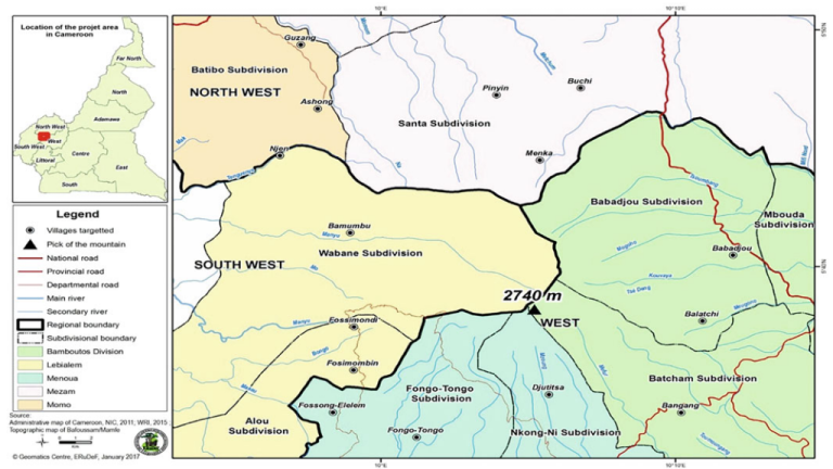
The Bamboutos Mountains are a group of volcanoes based on a swell in the Cameroon Volcanic Line shared by three administrative regions of Cameroon, merging in the north with the Oku Volcanic Field (Burke 2001). The large volcanic complex extends in a NE-SW direction for over 50 km, with the highest peaks rising to more than 2600 metres above sea level (m.a.s.l.) around the rim of a caldera with a diameter of 10 km. The upper part of the massif above 2000 m.a.s.l has a wet climate with more than 2500 mm of annual rainfall. The Bamboutos mountain landscape represents a key watershed. It gives rise to several rivers and lakes across the country, including the Mbam tributaries and Mifi tributaries (Ewane et al. 2021). Mt. Bamboutos is a biodiversity hotspot with a high degree of bird endemism and biodiversity. Some very important species of biodiversity endemic to this ecosystem include the primate Preuss’s guenon (Cercopithecus preussi), Cooper’s mountain squirrel (Paraxerus cooperi), the banded wattle eye (Platysteira laticincta), and Bannerman’s Turaco (Tauraco bannermani), as well as green monkeys. Other species include the endangered Cross River gorilla (Gorilla gorilla diehli) and the Nigeria-Cameroon chimpanzee (Pan troglotes ellioti). This ecosystem also plays host to viable populations of species from many taxa, especially insects, plants, reptiles, amphibians, and small mammals.
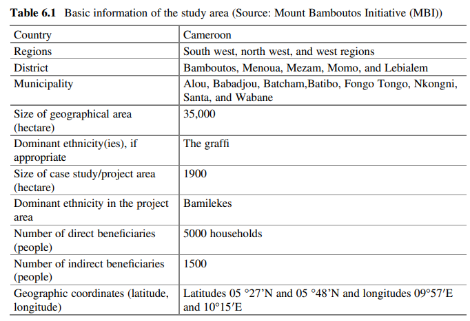
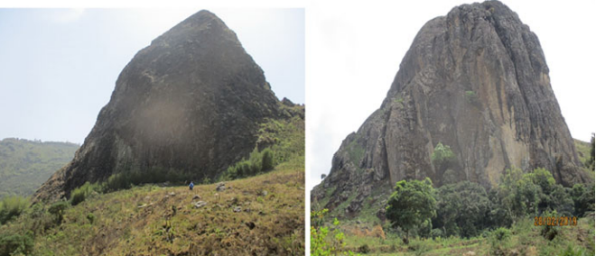
Besides its unique biodiversity, this mountain remains the only ecosystem in the country cutting across three administrative regions, namely West, South-West, and North-West, encompassing over 20 villages with a human population between 20,000 and 30,000 (Fig. 6.1, Table 6.1). Most of these people depend on the mountain and its biodiversity for their livelihood; they practice slash-and-burn and clear the forest for farmland, leading to high rates of deforestation, destruction of water catchments, and loss of biodiversity and soil fertility (Tankou et al. 2013). Due to population pressure, farming is carried out on the steep slopes, leading to erosion and loss of soil nutrients. Cattle grazing is a common practice on the upper slopes where food crop cultivation is uneconomical (Yerima and Van Ranst 2005). The destruction of almost all catchments has led to serious water shortages. Population pressure on limited land has resulted in encroachment into marginal sloping areas, causing continuous erosion and regular landslides (Fig. 6.2).
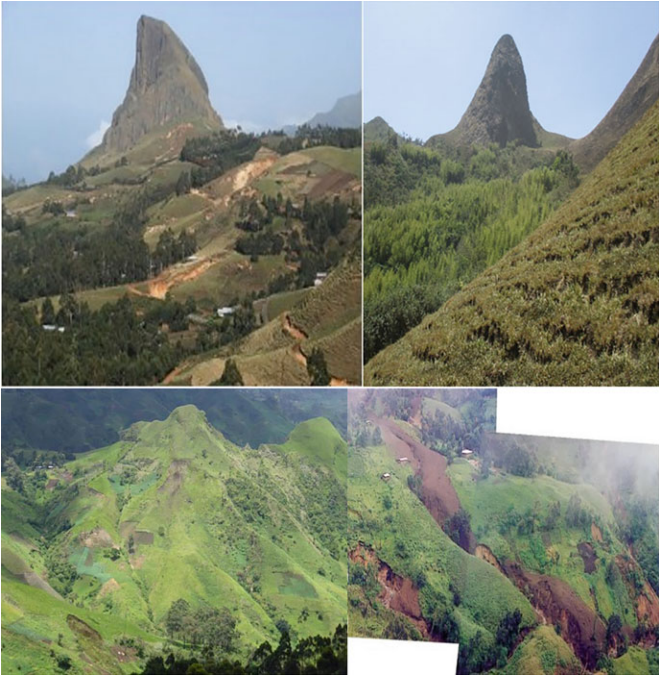
Intensification of agriculture and horticulture (Fig. 6.3) in the Mt. Bamboutos landscape has led to soil erosion, poor soil quality, and food and water contamination, and has resulted in decreased yields, reduced incomes, and food insecurity (Abubakar et al. 2020). Farmers use high levels of fertilisers and pesticides for horticultural crops and have a poor understanding of the real economic and environmental costs—hence the high risk of increased soil and agroecosystem degradation and declining crop yields. Poverty remains widespread and is strongly associated with rural livelihoods (Andrianarison et al. 2022). Toh et al. (2018) carried out a study on the socio-economic impact of land use and land cover change on the inhabitants of the Mt. Bamboutos Caldera of the Western Highlands of Cameroon and concluded that a majority of households were poor and lived in abject poverty.
Morphological, physical, and chemical studies on the soils of Mt. Bamboutos showed that the soils of this region can be divided into seven groups according to the US Soil Taxonomy: lithic dystrandept soils, typical dystrandept soils, oxic dystrandept soils, typical haplohumox soils, typical kandiudox soils, tropopsamment soils, and umbriaquox soils. These soils are organised into three main categories: soils with andic characteristics in the upper region of the mountain (lithic dystrandept soils, typical dystrandept soils, and oxic dystrandept soils); ferralitic soils in the lower part of the mountain (typical haplohumox soils and typical kandiudox soils), and imperfectly developed soils (tropopsamment soils and umbriaquox soils) (Tematio et al. 2004).
The soils are characterised by low bulk density (0.73 g/cm3 ) and a loamy texture with the low bulk density indicative of the andosolic nature of these soils, which might be due to more ground biomass input in the form of leaves. The soils’ highly fine particle (silt + clay) content is associated with the absence of translocation of finer particles from the surface horizons. The structural stability index is high, showing a stable structure (Nkembi et al. 2021).
1.1 Social, Cultural, Economic, and Environmental Aspects of the Study Area
The local population living within the Mt. Bamboutos ecosystem heavily depends on the agro-sylvo-pastoral sector. The average annual growth rate of the population is 2.5%. About 56% of the population is engaged in agricultural production. The Bororo minority community occupies areas of high altitudes devoted to cattle rearing (Fig. 6.4). The climate of Mt. Bamboutos is characterised by dry (November to March) and wet (April to October) seasons. Mean annual rainfall is 1918 mm, and mean temperature is 18.9 °C at an altitude of 2700 m (Kengni et al. 2009). About 80% of the food produced is based on the exploitation of natural resources, through agriculture, livestock, forestry, hunting, beekeeping, bark harvesting, wine tapping, roots, mushrooms, termites, the collection of water, and sacrifices on sacred sites. Data from monographs and technical reports show that agriculture and livestock farming are the main sources of income and livelihoods for the local population. The dynamism of the population based on the diversity of occupations and entrepreneurship rests on a certain number of parameters. These parameters derive from certain modes of social organisation that predispose and encourage entrepreneurship. They include: traditional micro-credit, self-help groups, age groups, and individual savings in local microfinance institutions, associations, and development committees.
Before the 1970s, the local population lived in the foothill zone of Mt. Bamboutos and reserved the mountain for livestock grazing. With the decrease in soil fertility in the foothills, they migrated to the mountains to carry out both agriculture and livestock rearing. The steepness of the slopes and relatively high altitude make the land ecologically fragile. Erosion and overgrazing are leading to landscape instability, and environmental threats are intensified by poor farming practices (Ngoufo 1992).
1.2 Farmland Management Strategies in the Mount Bamboutos Landscape
Farmland or agricultural land is prominent among human-influenced landscapes and ecosystems (Kanianska 2016). Its proper management is very important for food security and biodiversity conservation. Given that increasing land productivity represents a key element of any equation to boost rural socio-economic growth, land degradation is increasingly viewed by local stakeholders as important, and seen as both a cause and a consequence of the perpetuation of pervasive poverty. Farmland degradation is a global phenomenon that affects human societies at the local level, where rural communities closely related to land resources are vulnerable (Amenu and Birhanu 2018). The problem of farmland degradation, which results in low agricultural productivity, is particularly severe in rural communities (Qiu et al. 2017). The main outcome of land degradation is reduction in agricultural productivity. Cropland productivity loss at a rate of 0.5 to 1% per year was estimated by Pimentel and Burgess (2013), suggesting a productivity loss of at least 20% over the last 40 years compared with a situation without soil degradation. The combined effects of continuous tillage, soil erosion, overgrazing (Frankl et al. 2011), and other factors such as cultivation of marginal lands, unsustainable use of natural resources, deforestation, and unprecedented growth of human and livestock population (Million and Belay 2004), contribute significantly to farmland degradation. Farmland degradation also leads to loss of ecosystem services. The big challenge is to balance the need to provide enough food for a growing population while at the same time maintaining healthy ecosystems and habitats (Foresight 2011).
Given the importance of ecosystem services to the sustainability and security of agricultural systems, as well as the current rate at which those services are being degraded by agricultural systems, appropriate farmland management strategies are needed (Thorn et al. 2015). Alternative practices to conventional or intensive agriculture that preserve or enhance ecosystem services without compromising farm production have been proposed and may be adopted before, during, or after cultivation (Mupangwa et al. 2012). These strategies could be active, such as surface crop residue management, or passive, such as the existence of native vegetation patches in fields. Farmland management practices may incorporate principles, among others, of multifunctional agriculture (producing food and non-food commodities, maintaining wild crop varieties, traditional landraces, and local culture (Leakey 2012), and sustainable intensification, i.e. relieving pressure on land expansion and limiting forest encroachment (Dile et al. 2013)), and conservation agriculture, or practices of no-tillage, permanent soil cover using crop residues or cover
crops, and crop rotation (Friedrich et al. 2009). Such practices often require minimal inputs with opportunities for enhancing smallholder production (Mupangwa et al. 2012). Details on the effects of various strategies on farmland quality were summarised by Thorn et al. (2015). Growing leguminous cover crops fixes nitrogen, retains moisture, stimulates root growth, and encourages belowground microbial activity. No- or minimum-till systems and crop rotation influence soil organic carbon sequestration and crop yield. Fallowing helps to suppress leaching and erosion of organic matter and nutrients, and increases soil cation exchange capacity. Intercropping regulates detrimental pest populations and enhances natural enemy populations. The intercropping of trees with shade-tolerant crops, or multistory cropping, reduces the presence of weeds, and promotes nutrient cycling.
Organic and inorganic fertilisers are used for soil fertility enhancement in farmlands. Fertiliser use, particularly nitrogen (N), is an important management practice to increase crop production and improve soil fertility. Thus, the use of soil fertilityenhancing amendments to supply essential nutrients in crop production is of critical importance. Along with the nutrient supply from soil organic matter, crop residues, wet and dry deposition, and biological nitrogen fixation, synthetic (inorganic) fertilisers are also sources of essential nutrients in crop production (Jeetendra et al. 2021). Some researchers have encouraged farmers to adopt the combined application of manure and fertilisers to decrease the dependence on inorganic fertilisers (Kifayatullah et al. 2020).
The overall objective of the study was to identify and document farmland management strategies used by smallholders in the Mt. Bamboutos landscape. The specific objectives were:
- To document the socio-demographic situation of smallholders in the Mt. Bamboutos landscape.
- To establish the farmland soil fertility management practices used by smallholder farmers in the Mt. Bamboutos landscape.
- To determine uptake of soil management by smallholders.
- To determine food and nutrition security status of households within the
landscape.
2 Methods
2.1 Participatory Monitoring of Impacts of the Project on the Landscape
A survey was carried out after 3 years of implementation of the project whereby farmers in this landscape were trained on soil fertility management practices, and questionnaires were administered to 203 farmers who were active in the project and willing to participate in the survey. The survey used semi-structured questionnaires to collect information on the following:
- Socio-demographic situation of respondents
- Uptake of soil management practices
- Household food security and nutrition status
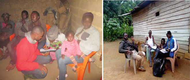
The questionnaires were pre-tested and corrected based on the test results before being used for data collection. Family heads were the main respondents during questionnaire administration. However, any elder person responded in the case where the family head was not available. Family heads were targeted because they make most of the decisions in the household, including those on farming. The food security situation of the population was also assessed using the household food insecurity access scale (HFIAS) (Coates et al. 2007). Typical scenes during questionnaire administration are presented in Fig. 6.5.
At least 20 respondents were interviewed per village. These respondents could be youths, men, or women, provided they were family heads. One focus group discussion (FGD) was conducted in each of the 20 villages, and after discussing, the interviewers assisted those who could not write, while questionnaires were handed to those who could read and write to fill in.
2.2 Survey Data Analysis
Data collected was processed and keyed into the SPSS software package version 6.0. Descriptive statistics (frequency, percentages), and the household food insecurity access scale (HFIAS) were used to analyse the data. Following the HFIAS, households were categorised into: severely, moderately, and mildly food insecure and food secure households.
3 Results
3.1 Socio-Demographic Situation of Respondents
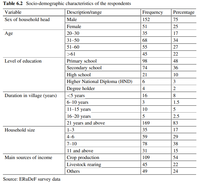
The households were male dominated with 75% of respondents being male (Table 6.2). Most respondents were middle-aged people (31–50 years). People belonging to this age group are known to be at their most productive period in life. It was interesting to note that the respondents had at least a primary level of education—none of the respondents were illiterate. Large household sizes are a source of labour for family farms (Mbu et al. 2019). Children work with their parents on the farms, especially during weekends and holidays. For most of the villagers, hiring labour was not viable, so they depended mostly on their families for labour. Large household sizes also reflect the fact that polygamy is practiced in most of the villages. Some villagers have more confidence in their family members than hired labour; the job is properly done and there are no incidents of theft. The primary source of income for the respondents was crop production, followed by animal production (Table 6.2).
3.2 Farmland Soil Fertility Management Practices
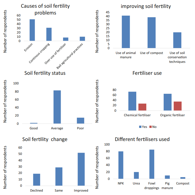
Farmers were trained in farm management practices and supervised through these practices during the course of the project. Farmers were able to discern the fertility status of their farmlands and determine some causes of soil fertility decline (Fig. 6.6). This was encouraging in that when farmers come to know the causes of decline, they can then make efforts to avoid or mitigate them. The results showed that 80% of the farmers rated their farmlands as averagely fertile (Fig. 6.6). Four major causes of soil fertility decline were evoked by the farmers, namely: soil erosion, continuous cropping, overuse of synthetic fertiliser, and bad agricultural practices (e.g. slash and burn). Erosion was identified as the main cause of soil infertility. This is logical because farmers in this area farm on steep slopes, which are easily eroded. Soil erosion reduces the agricultural value of lands via physicochemical degradation. Soil nutrient loss through runoff and sedimentation is a major driver of soil fertility decline. The eroded sediments or soil are highly concentrated with crop nutrients, which are washed away from farmlands (Bashagaluke et al. 2018).
Half of the respondent farmers acknowledged that the fertility of their soil improved, while 30% reported no change in soil fertility. Another 20% said the fertility of their farmland declined. Improved soil fertility should be linked to proper practice of lessons learnt during the project. Soil fertility improvement is visible for short-duration crops like vegetables and maize. Usage of manures improves soil fertility within a short timeframe because the nutrients from the compost are readily available for plant uptake.
The farmers used both organic and inorganic fertilisers for crop production. The main inorganic fertilisers used were nitrogen, phosphorus, and potassium, or NPK 20-10-10, and urea, while the organic fertilisers (manures) were fowl droppings, pig manure, and compost manure. Potassium (K), besides N and P, is an important nutrient needed for plant growth and development. Likewise, these three elements improve seed germination, root development, crop yield, and resistance to pests and diseases. Since most smallholder farmers do not test their soils before fertiliser application, they prefer to use compound fertiliser like NPK 20-10-10 to guarantee that all nutrients will be available for their crops. This explains why fewer farmers used urea, which is a simple fertiliser. Fowl droppings were the most used organic manure, which could be attributed to the fact that most of the farmers rear chickens in cages where they can conveniently collect the droppings for farmland fertilisation. Some buy fowl droppings from the nearby city of Bafoussam, where there are large poultry farms. The farmers reported the use of animal manure, compost manure, and good farming practices as ideal means of improving soil fertility (Fig. 6.6). Manure is a natural fertiliser containing essential elements required for plant growth. Its application to cropland restores or replenishes soil fertility. It reduces soil erosion, restores eroded croplands, and reduces nutrient leaching. All these factors positively affect crop yield, and are therefore expected to contribute to food security (Teenstra et al. 2016).
3.3 Cropping Systems Practiced
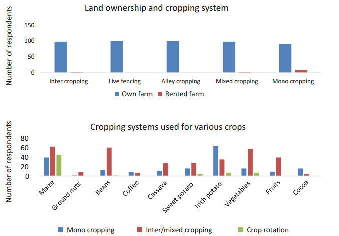
Several cropping systems were practiced in production landscapes as a means of maximising land productivity. The results showed that access to land greatly determined the cropping system practiced by farmers (Fig. 6.7). Farmland cultivated was either owned or rented, and most farmers practiced restricted types of cropping systems on rented lands. On their own land, they used a variety of cropping systems. The restriction could be attributed to the different terms of agreement for those who lease land. Therefore, the mode of access to land influences the management of farmlands in the landscape. Live fencing and alley cropping were not reported on leased land. A detailed study on buying and renting land in the Bamboutos mountains by Nzoffou et al. (2020) found that two types of rental systems were practiced: long term and short term. A long-term lease referred to a contract that had at least a 5-year renewable term with a royalty paid per crop year. A short-term rental referred
to contracts with a renewable one-year term. In short-term rentals, the tenant is called upon to engage in new negotiations at the end of the contract, and the full rental fee is generally paid before the start of the crop year. The tenant must not plant perennial crops and trees, only short-cycle crops are allowed. The results of this study show that leased farmlands were on a short-term basis.
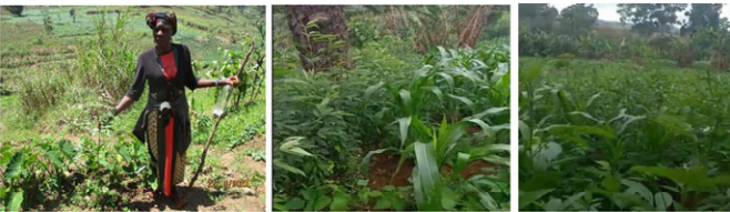
The farmers had the choice of what crop to use for which cropping system. Cash crops (cocoa and coffee) were planted mainly in mono and mixed cropping systems. Short-cycle crops (maize, beans, Irish potatoes), in addition to being planted in mono and mixed cropping systems, were also planted in crop rotational systems. In a country-wide study, Abia et al. (2016) reported that mixed cropping or crop rotation could go a long way to solve problems faced and boost future crop production in Cameroon. Mixed cropping or crop rotation helps to reduce the spread of rapid attacks on crops by pests and diseases, hence increasing food availability and supply. Sample mixed cropping systems are presented in Fig. 6.8.
3.4 Agroforestry Practices and Organic Manure Production
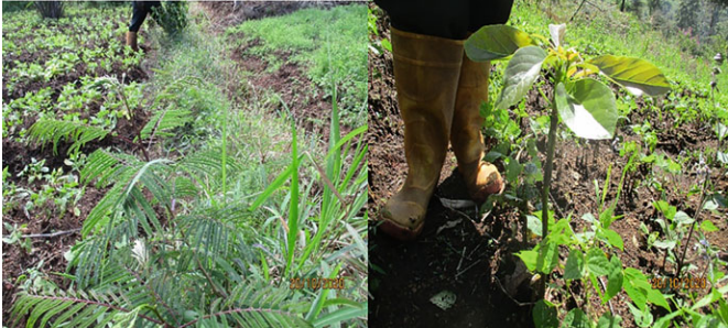
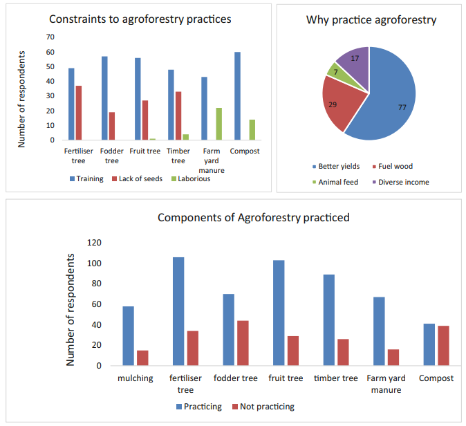
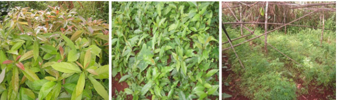
The agroforestry system in this area refers to scattered trees on cropland—an agrosilvicultural agroforestry system. In this system, trees and shrubs are either planted or maintained within agricultural lands (Njukeng et al. 2021) (Fig. 6.9). They could equally be described as homegardens. During implementation of the project, emphasis was placed on agroforestry practices because of their importance for ecosystem restoration and farm diversification. Farmers were trained and supervised on the different components of agroforestry practices and organic manure production methods. The farmers gave four main reasons for practicing agroforestry: improved crop yields, fuel wood, fodder, and diverse income. The main components of agroforestry practiced by farmers in the study site were: planting of fertilsser, fodder, fruit, and timber trees in cropland. The main ways of producing organic manure were through mulching, composting, and farmyard manure preparation (Fig. 6.10). The three main constraints for practicing agroforestry and preparing organic manures were stated to be: lack of training, lack of seeds, and excessive labour. Examples of fertiliser and fruit tree-based agroforestry systems are presented in Fig. 6.10. Fertiliser trees are known to add nutrients to the soil through nitrogen fixing in the nodules or when their leaves fall and are incorporated into the soil. The main species planted in the study area was Leucaena leucocephala, which is used as manure and fodder. Fodder trees are used to feed animals. Their leaves and soft branches are harvested and fed to animals. Fruit trees provide food for family consumption as well as for income generation. The most planted fruit tree in the study area was the avocado (Persea americana). Timber trees are used for construction, furniture production, or sold for income generation. They also provide fuel wood for farmers.
3.5 Nursery Establishment
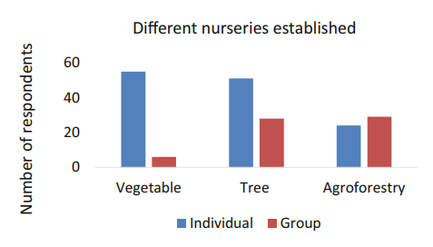
Nurseries were established either as community (group) or individual nurseries. Vegetable, tree, and agroforestry nurseries were established (Fig. 6.11). Most of the vegetable nurseries were owned by individuals, while agroforestry and tree nurseries were mostly owned by community groups. Tree nurseries included fruit trees and timber trees, while agroforestry nurseries contained fodder and fertiliser tree species. Group nurseries (Fig. 6.12) were generally larger than individual nurseries. This is because there are many community members belonging to the group that dedicates time to take care of the nurseries, compared to individual nurseries where labour is limited to the nursery owner and family.
3.6 Food and Nutrition Security
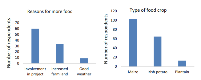
Soil fertility management on farmland was undertaken to ensure good and sustainable crop yields and hence food and nutrition security. Farmers plant different crops for diversified income and nutrition. The main staple crops were maize, Irish potatoes, and plantain (Fig. 6.13). Of all respondents, 49% acknowledged that their food production had improved, while 51% responded that they did not realise any improvement. The research team analysed the reasons for food improvement and found that involvement in the project was the primary reason, followed by an increase in farmland, and lastly, good weather conditions (Fig. 6.13).
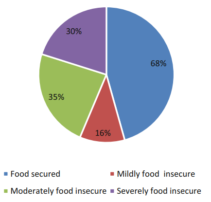
The food security situation of the studied population was assessed. Results showed that 35% of respondent households were food secure, and 30% were severely food insecure (Fig. 6.14). Efforts to address food security in the landscape should be intensified to increase the number of food secure households.
4 Conclusion and Lessons Learnt
Farmers have acquired numerous skills in farmland soil fertility management. However, practice of any of the techniques was highly dependent on land access. The farmers used both organic and inorganic (synthetic) fertilisers for crop production as well as agroforestry practices. Acquiring these skills has gone a long way towards improving food and nutrition security at the household level. Constraints in practicing agroforestry and organic manure production were inadequate training, lack of seeds, ignorance, and the amount of labour required for some of the activities. Lack of information about good farm management practices was evident. This ignorance is an indication that training and sensitisation on good soil fertility management practices need to continue. Continuation would help to further improve the food and nutrition situation of households. Likewise, proper farmland soil management would reduce encroachment into the mountain landscape and thus conserve biodiversity.
The future challenges identified during the course of this study are:
- Sustaining coordination and communication between the different stakeholders.
- Perverse incentives that promote unsustainable practices (e.g. excessive use of chemicals in farming).
- Effects of climate change and extreme weather conditions.
Lessons Learnt
- Good farmland management practices led to improved farm yields, thus improving the situation of food security.
- Agroforestry and mixed cropping practices helped farmers to diversify their farm produce as well as income sources. This helped the farmers to rely mostly on their farm production rather than relying on illegal harvesting of products from the forest.
- Capacity building should be enhanced to ensure that a good number of farmers master the various soil fertility management practices. This will ensure better crop yields to ensure food security and reduce reliance on the forest, thus conserving biodiversity.
Acknowledgements We gratefully acknowledge the financial support of TreeSisters and the Darwin Initiative, and the technical support of the International Tree Foundation (ITF) and the International Union for the Conservation of Nature (IUCN). The collaboration of local communities, especially the smallholder farmers, is highly appreciated.
References
Abia WA, Shum CE, Fomboh RN, Ntungwe EN, Ageh MT (2016) Agriculture in Cameroon: proposed strategies to sustain productivity. Int J Res Agric Res 2(2):1–3
Abubakar AS, Fondo TA, Nyong PA (2020) Agroforestry for sustainable agriculture in the Western highlands of Cameroon Haya. Saudi J Life Sci 5(9):160–164
Amenu L, Birhanu I (2018) Determinants of farmland degradation and its implication on crop productivity and sustainability. J Appl Sci Environ Manag 22(8):1225–1232
Andrianarison F, Housseini B, Oldiges C (2022) Dynamics and Determinants of monetary and multidimensional poverty in Cameroon. OPHI Working Paper 141. University of Oxford
Bashagaluke JB, Logah V, Opoku A, Sarkodie-Addo J, Quansah C (2018) Soil nutrient loss through erosion: impact of different cropping systems and soil amendments in Ghana. PLoS One 13(12):e0208250
Burke K (2001) Origin of the Cameroon Line of Volcano-Capped Swells. J Geol 109:349–362. https://doi.org/10.1086/319977
Coates J, Swindale A, Bilinsky P (2007) Household food insecurity access scale (HFIAS) for measurement of household food access: indicator guide, vol 3. FHI 360/FANTA, Washington, D.C.
Dile YT, Karlberg L, Temesgen M, Rockström J (2013) The role of water harvesting to achieve sustainable agricultural intensification and resilience against water related shocks in sub-Saharan Africa. Agric Ecosyst Environ 181:69–79
Ewane BE, Asabaimbi DN, Njiaghait YM, Nkembi L (2021) Agricultural expansion and land use land cover changes in the mount Bamboutos landscape, Western Cameroon: implications for local land use planning and sustainable development. Int J Environ Stud 80:186. https://doi.org/10.1080/00207233.2021.2006911
Frankl A, Nyssen J, De Dapper M, Mitiku H, Deckers J, Poesen J (2011) Trends in gully erosion as evidenced from repeat photography (North Ethiopia). Landform Analys 17:47–50
Friedrich T, Kienzle J, Kassam A (2009) Conservation agriculture in developing countries: the role of mechanization. In: Seminar on innovation for sustainable agricultural mechanisation, Hannover, Germany, 8 November 2009. Food and Agricultural Organization
Foresight (2011) The future of food and farming executive summary. The Government Office for Science, London
Jeetendra PA, Sapkota TB, Krupnik TJ, Rahut DB, Jat ML, Stirling CM (2021) Factors affecting farmers’ use of organic and inorganic fertilizers in South Asia. Environ Sci Pollut Res 28: 51480–51496
Kanianska R (2016) Agriculture and its impact on land-use, environment, and ecosystem services. In: Almusaed A (ed) Landscape ecology. Intech Open
Kengni L, Tekoudjou H, Tematio P, Pamo Tedonkeng E, Tankou CM, Lucas Y, Probst JL (2009) Rainfall variability along the southern flank of the Bambouto mountain (West-Cameroon). J Cameroon Acad Sci 8(1):45–52
Kifayatullah K, Xuan TD, Zubair N, Shafiqullah A, Gulbuddin G (2020) Effects of organic and inorganic fertilizer application on growth, yield, and grain quality of rice. Agriculture 10:544
Leakey RB (2012) Multifunctional agriculture and opportunities for agroforestry: implications of IAASTD. In: Nair PKR, Garrity D (eds) Agroforestry-the future of global land use. Dordrecht, Springer, pp 203–214
Mbu DT, Nganje SN, Chuo JN (2019) Intricacies of organic and chemical fertilizer application on arable land crop production in Cameroon. J Socioecon Develop 2(2):61–72
Million T, Belay K (2004) Factors influencing adoption of soil conservation measures in Southern Ethiopia: the case of Gununo area. J Agric Rural Develop 105(1):49–62
Mupangwa W, Twomlow S, Walker S (2012) Reduced tillage, mulching and rotational effects on maize (Zea mays L.), cowpea (Vigna unguiculata (Walp)L.) and sorghum (Sorghum bicolor L. (Moench)) yields under semi-arid conditions. Field Crop Resarch 132:139–148
Ngoufo R (1992) The Bamboutos mountains: environment and rural land use in West Cameroon. Mt Res Dev 12(4):349–356
Nkembi L, Deh NH, Tankou CM, Njukeng JN (2021) Analysis of small scale farmers households food security in the mount Bamboutos ecosystem. J Food Secur 9(2):56–61. https://doi.org/10.12691/jfs-9-2-3
Njukeng JN, Nkembi L, Tankou CM, Deh NH, Ngulefack EF (2021) Soil fertility management practices by smallholder farmers in the Bamboutos Mountain ecosystem. World J Agric Res 9(2):58–64. https://doi.org/10.12691/wjar-9-2-3
Nzoffou JL, Fongang GH, Kaffo C (2020) Buying and land rental in the mountains: what are the challenges for the development of modern farms? Case of the Bamboutos Mountains – West – Cameroon. Int J Rural Develop Environ Health Res (IJREH) 4(4):154–162
Pimentel D, Burgess M (2013) Soil erosion threatens food production. Agriculture 3(3):443–463 Qiu LL, Koondhar MA, Liu Y, Zeng WZ (2017) Land degradtion is the instinctive source of poverty in rural areas of Pakistan. IOP Conf Series Earth Environ Sci 86(1):012003
Tankou CM, de Snoo GR, de Iongh HH, Persoon G (2013) Soil quality assessment of cropping systems in Western highlands of Cameroon. Int J Agric Res 8(1):1–16
Teenstra E, Andeweg K, Vellinga T (2016) Manure helps feed the world: integrated manure management demonstrates manure is a valuable resource. In: Climate-smart agriculture practice brief. CGIAR Research Program on Climate Change, Agriculture and Food Security (CCAFS), Copenhagen
Tematio P, Kengni L, Bitom D, Hodson M, Fopoussi JC, Leumbe O, Mpakam HG, Tsozué D (2004) Soils and their distribution on Bambouto volcanic mountain, West Cameroon highland, Central Africa. J Afr Earth Sci 39:447–457
Thorn J, Snaddon J, Waldron A, Kok K, Zhou W, Bhagwat S, Willis K, Petrokofsky G (2015) How effective are on-farm conservation land management strategies for preserving ecosystem services in developing countries? A systematic map protocol. Environ Evidence 4(11):1–13
Toh FA, Angwafo T, Ndam LM, Antoine MZ (2018) The socio-economic impact of land use and land cover change on the inhabitants of mount Bamboutos caldera of the Western highlands of Cameroon. Adv Remote Sensing 7:25–45
Yerima BPK, Van Ranst E (2005) Major soil classification systems used in the tropics: soils of Cameroon. Trafford Publishing. 1-4120-5789-2
Note
The opinions expressed in this chapter are those of the author(s) and do not necessarily reflect the views of UNU-IAS, its Board of Directors, or the countries they represent.
Open Access This chapter is licenced under the terms of the Creative Commons AttributionNonCommercial-ShareAlike 3.0 IGO licence (http://creativecommons.org/licenses/by-nc-sa/3.0/ igo/), which permits any noncommercial use, sharing, adaptation, distribution and reproduction in any medium or format, as long as you give appropriate credit to UNU-IAS, provide a link to the Creative Commons licence and indicate if changes were made. If you remix, transform, or build upon this book or a part thereof, you must distribute your contributions under the same licence as the original. The use of the UNU-IAS name and logo, shall be subject to a separate written licence agreement between UNU-IAS and the user and is not authorised as part of this CC BY-NC-SA 3.0 IGO licence. Note that the link provided above includes additional terms and conditions of the licence.
The images or other third party material in this chapter are included in the chapter’s Creative Commons licence, unless indicated otherwise in a credit line to the material. If material is not included in the chapter’s Creative Commons licence and your intended use is not permitted by statutory regulation or exceeds the permitted use, you will need to obtain permission directly from
the copyright holder.