Effective Water Management for Landscape Management in the Siem Reap Catchment, Cambodia (SITR7-7)
03.03.2023
SUBMITTING ORGANIZATION
Live and Learn Environmental Education
DATE OF PUBLICATION
06/2022
REGION
Asia
COUNTRY
Cambodia
KEYWORDS
Angkor, Siem Reap · Diversification · Climate change · Food security · Ecosystem services, Nature-based solutions
AUTHOR(S)
Chris Jacobson, Jady Smith, Socheath Sou, Christian Nielsen, and Peou Hang
LINK
Abstract
International awareness of the world-renowned Angkor Wat temple complex has drawn attention to the challenges of climate change, deforestation, and water management in Cambodia. The aim of this chapter is to examine the benefits of enhanced water management provided within Angkor Archaeological Park, and to consider challenges to maintaining those benefits. The Authority for the Protection of the Site and Management of the Region of Angkor (APSARA) designed and in 2014–2018 implemented within the Park a water management project to recharge groundwater supplies, mitigate floods, and provide irrigation. To assess the benefits, we draw on an economic analysis of ecosystem service changes, including interviewing 145 households from across the Park and four experts. To assess challenges to sustaining the benefits, we also interviewed 73 households and conducted 12 focus group discussions in the upper catchment. We used a combination of quantitative analysis (i.e. economic assessment) and qualitative data analysis (e.g. thematic analysis). Our analyses of data from people living in and around the Park showed that improved water management (e.g. reinforcing dykes and storage facilities for groundwater recharge) and investment in economic diversification (e.g. tourism, horticulture, and heritage crops projects) reduced vulnerability of the people to climate hazards. Currently, these benefits are threatened by forest loss in the upper Siem Reap catchment. Our analysis of data from the upper catchment showed that forest loss also resulted in detrimental effects to human health and well-being and was associated with higher food insecurity. Solutions are suggested to enhance nature-based employment opportunities and promote economic diversification. This would extend the scope of management of this socio-ecological production landscape (SEPL) beyond the Park and ensure its sustainability by improving
the health and well-being of the people living in the upper catchment.
1 Introduction
Management of human-nature interactions has occurred across millennia in the Angkorian landscape (Siem Reap Province). Angkor Archaeological Park is one of the most important archaeological sites in Southeast Asia. It contains the remains of various capitals of the Khmer Empire. In 1992, Angkor Archaeological Park was recognised by the United Nations Educational, Scientific and Cultural Organization (UNESCO) as a world heritage site. Its listing highlights not only archaeological heritage, but also the linkages between tangible heritage (e.g. temples) and intangible heritage (e.g. forest conservation, water management). Thus, the Park is a socio-ecological production landscape (SEPL) based within one of the largest archaeological sites in the world.
The Park is threatened by (1) limited protection of upstream ecosystems, which impacts the groundwater recharge and availability within the Park, and (2) pressure from communities in the surrounding rural areas, for whom harvesting natural resources (such as forests) is an easy but unsustainable form of livelihood. In the upper Siem Reap River catchment, forest degradation resulted in loss of 36.6% of forest area between 1989 and 2019, and changes in structure and composition (Chim et al., 2019; Wales, 2020). Most of the loss resulted from conversion for agriculture (Chim et al., 2019) due to increased population pressure on the land, as evident in decreased landholding size (National Institute of Statistics, 2009, 2017). These changes have increased run off, increasing sediment levels in the lower catchment ponds and lakes, with potential impacts on fishery productivity (Chim et al., 2021). The result is an overall trend towards a drier landscape with less precipitation (Jacobson et al., 2019) and changes to the flood pulse in the Tonle Sap lake (Frappart et al., 2018). In addition, there is increased water consumption for household use and agriculture, which lowers groundwater levels and consequently reduces
supply, and potentially temple stability (Kirsch, 2010; Chim et al., 2021).
In response to these challenges (i.e. agricultural expansion, deforestation, and changes in water availability), the Ministry of Foreign Affairs and Trade of New Zealand (MFAT) supported the Authority for the Protection of the Site and Management of the Region of Angkor (APSARA) to conserve and restore an archaeological hydraulic engineering system and support livelihood advancement projects within the Park (2014–2018). However, the benefits of these activities have as yet not been documented. In addition, the importance of application of effective management systems beyond the Park boundaries has not been assessed. This chapter examines the potential effectiveness of the project’s activities to enhance the resilience of this SEPL. It demonstrates how project interventions addressed the nexus between ecosystem health and human well-being, and the importance of their extension beyond the Park boundary. The case is significant as a study of reinvigoration of traditional water and landscape management, demonstrating the benefits from combining modern engineering technologies with traditional knowledge through heritage conservation.
2 Background and Methods
2.1 The Angkor World Heritage Site and Its Significance
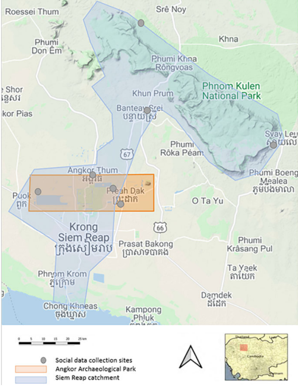
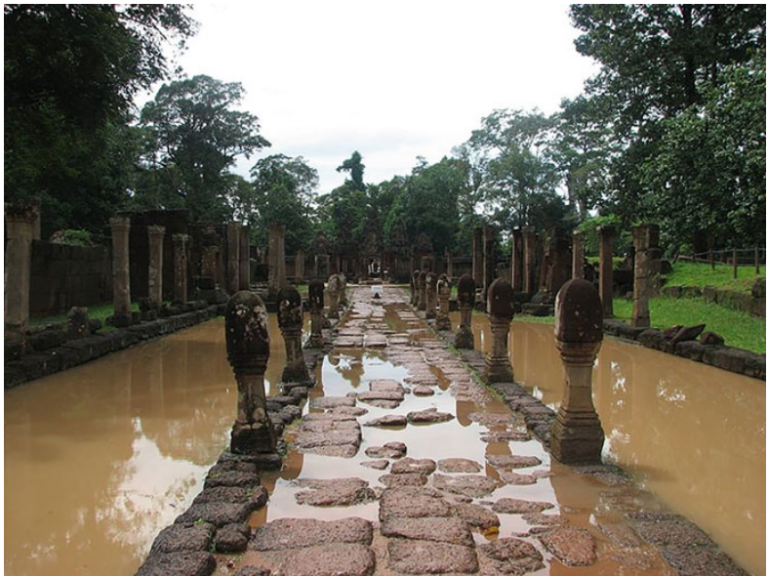
Situated in the province of Siem Reap, Angkor Archaeological Park, “the Park” (Fig. 7.1 and Table 7.1), is one of the most important archaeological sites in Southeast Asia, as well as a major tourist attraction (Hang et al., 2016). The Park stretches over 400 km2 and contains the remains of various capitals of the Khmer Empire which flourished over six centuries from the early ninth century. It includes temples (e.g. world-renowned Angkor Wat), hydraulic structures (e.g. basins, dykes, reservoirs, canals), and forested areas. Angkor is considered a “hydraulic city” because of its complicated water management network used for systematically stabilising, storing, and dispersing water throughout the area. The temple complex is supported by three river systems stretching 50 km upstream. Lakes, moats, ponds, and royal basins saturate the sand-clay soils supporting the temples, ensure temple stability, enable irrigation, and support the food security of the increasing local population; they also provide flood protection to Siem Reap city (Hang et al., 2016; Chim et al., 2019). The Angkorian water management system includes a series of moats and lakes with spillways, connected by canals (see Chim et al., 2021 for a diagrammatical representation). Water gates direct and control water flows, while intact canals, reservoirs, and spillways direct water to or away from where it is needed for agriculture purposes. Canals whose walls are partially eroded result in a loss of water from those canals. Moats and lakes recharge groundwater, and provide water storage, limiting floods in the wet season and mitigating against drought in the dry season. Recent LiDAR analyses (e.g. Chen et al., 2017; Evans, 2016; Wales, 2020) provide scientific analysis of the spatial scale of these structures beyond the Park. The analysis demonstrated that ancient water management occurred across the whole landscape, not just within the Park boundaries as currently occurs.
2.2 Angkor Park Management Projects
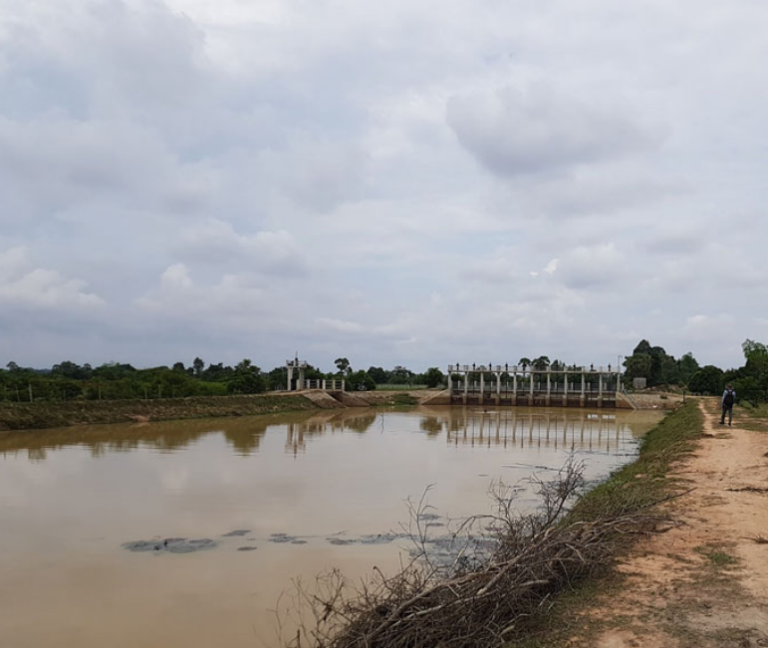
In partnership with APSARA, the New Zealand MFAT has invested in making the management of the Park more resilient since 2010. This has included development of a Park plan and enhancement of capacity for community based natural resource management within the Park. In 2014, the Angkor Community Heritage and Economic Advancement Project (ACHA) (2014–2019) was initiated. The goal of this project was to increase food security and promote sustainable management, including revitalisation of ancient water management across the entire Park. An evaluation of this project provided understanding of the benefits of the water management component. The ACHA project activities included (1) 16 new or repaired gates, and rehabilitation of dykes, moats, and spillways, and (2) enhanced water storage through the new and rehabilitated storage structures (>1,700,000 m3 storage) (Fig. 7.2 provides an example). Water storage activities were designed to ensure soil water saturation, support temple stability, as well as capture water for irrigation during the wet season (>1730 ha irrigated paddy under cultivation) and in the dry season (20 ha irrigated paddy under irrigation). This chapter documents the benefits of these water management activities to the SEPL.
2.3 Assessing the Impacts of Existing Management
and Future Opportunities
This case study was based on an assessment of ecosystem service benefits associated with the water management activities within the Park by comparing to areas beyond it. It draws on two sets of previously unpublished data.
Data Collection
We used two data sets to assess the impacts of existing management and futureopportunities. The first data set was used to assess the economic benefits of ACHA water management to people living in the Park, where provisioning, regulating, and cultural services provided by the ecosystem were identified.1 Indicators used were:
- Changes in the economic value of local livelihoods—provisioning services (household interview data)
- Changes in the value of tourism—provisioning services (calculation using the Ministry of Tourism data and data from APSARA staff interviews)
- The value of improved flood management—regulating services (calculation using household interview data, and data on flood impact costs from ADB (2012))
- Changes in the value of cultural services provided (calculated using transfer values)
Household interviews were used to inform the assessment of changes in local livelihoods. The Cambodian local government structure formed the basis of household interviewee selection, and is organised in district-commune-village-household hierarchy. We conducted 145 household interviews. Household selection was based on the following steps:
- Selection of one target commune from each of the five districts, ensuring representation from the north, west, east, centre, and south of the Park where soil quality and tree density differ, also reflecting agriculture and livelihood diversity observed during field visits
- Within the boundaries of a target commune, random selection of at least 1.5% of all households (minimum sample size of 15) stratified by villages wholly within the Park. This provides for a margin of error of <10%; the ability to provide precise estimates is limited by a lack of sample frame data
These interviews were conducted with 118 participants in 2018 in Khmer language by APSARA staff. Structured questions (quantitatively analysed using
descriptive statistics) were included about:
- Flood frequency (reflecting on frequency before and after ACHA water infrastructural development between 2016 and 2018) and flood impacts (before and after infrastructural development, using an ordinal scale)
- Livelihood activities (before and after water infrastructural development), including farmgate value (i.e. value when purchased from the farmer) or wholesale produce value (i.e. value when purchased from a wholesaler) and enterprise value (i.e. for non-agricultural produce)
- Food security, using Food Insecurity Experience Scale (Carletto et al., 2013)
- Debt
Lastly, APSARA staff were interviewed to understand the reduction in flooding frequency and extent in the Park that resulted from improved water management; this provided data on the number of days of Park closure that enabled assessment of benefits of water management associated with tourism. The four interviewed APSARA staff members were not involved in the household interviews on changes in flood frequency and their impacts on food security and livelihoods.
The second data set, collected in 2020,3 provides reference values that enable comparative analysis with data on Park management. It provides understanding about broader landscape management constraints that have impact upon the Park, and the ability to maintain the benefits derived from the ACHA project. It included 73 semi-structured interviews conducted in four communes in the upper and mid-Siem Reap catchment outside of the Park (40 females, 33 males). It also included 12 focus group discussions, which engaged an additional 93 community participants (50 females, 43 males) and local government officials (3 female, 23 male) associated with each commune. This sample size was considered appropriate given the exploratory intent and qualitative nature of this research.
For the second data set, interviews were based on questions about the following topics that were qualitatively analysed:
- Current uses of natural resources
- Changes in the frequency and impacts of weather events
- Challenges to the management of land, water, and forests
- Perceptions about environmental quality, changes in it, and predictions about the future
For the second data set, focus group discussions were based on the topics of:
- Environmental quality, including changes in ecosystem services
- Livelihood benefits from native biodiversity
- Adaptation and change in livelihoods in response to shocks, changes, and/or disasters
- Engagement in decision-making and information sharing
Data Analysis Methods
For the first data set, we provide analyses of household data. We then combined this primary data with values from other Cambodia studies (ADB, 2012) to conduct economic valuation of the different types of ecosystem services affected by water management.
Average household livelihood changes were scaled to the total number of households in the Park, and then assigned an attribution range4 of 10–20%. This attribution range was based on an expert assessment by hydrologists in APSARA, and recognised that water was one factor contributing to improved agriculture livelihoods.
The value of tourism changes was calculated using ticket value, visitor numbers, and changes in Park access. Park access changes when flooding occurs and tourists are unable to visit, resulting in a loss of revenue. We asked experts to estimate the total average of days of closure before and after water management, and their responses provided conservative and upper bounds of the value of tourism changes, which we provided to represent the lack of certainty on the impacts to tourism across the entire park (i.e. a closure rate of between 2 and 4 days per year).
The value of flood protection to Siem Reap province was calculated using avoided cost estimates, based on the costs of flood impacts associated with typhoon Ketsana (ADB, 2012). This typhoon impacted Siem Reap Province before ACHA project activities occurred, but only impacted the population within the Park and downstream of it. The values from this ADB study were multiplied by the proportion of the population living in the province at the time that was impacted, and multiplied by changes in annual flood probability (expert assessments of 10% annual likelihood pre-ACHA, reduced to 1–2% after ACHA activities).
Lastly, cultural service values attributable to ACHA water management were assessed by determining existence values. We used transfer values based on the willingness to pay for cultural heritage (temples) presented in studies from Thailand and Vietnam (Seenprachawong, 2006; Tuan et al., 2009), adjusting for per capital GDP inflation since they were conducted. The per capita existence value was scaled to the entire population of Cambodia and ten million international visitors, per year. Attribution values of 5–10% account for the potential share of water management in the temples’ existence.
The second data set was analysed using thematic coding, and data are presented on the themes of forest uses, water and climate, health impacts associated with landscape change, connections between upper catchment and the Park, and prospects for the future.
2.6 Limitations
The project used ex post techniques5 to evaluate the impacts of a development project. One limitation of this technique is the breadth of indicators that can be included. While additional indicators and specific measures (e.g. health and biodiversity metrics) are relevant and potentially of interest to many involved in SEPL management, a lack of reference data for comparing change makes them less meaningful for impact assessment. The use of data from the upper catchment is primarily to contextualise the impact of the project, and its sustainability. The limitations of use of data from the upper catchment to assess benefits from a project implemented in the Park are acknowledged.
While health was not an explicit focus during data collection, the qualitative analysis does highlight the linkages between water and health, focusing on health in terms of the well-being of communities. Likewise, we use the forests and their protection (or lack thereof) as an indicator of biodiversity.
3 Results
3.1 Understanding the Impacts of Water Management in Angkor Park
Interviewees’ responses indicated a reduction in flood frequency and impacts following implementation of the ACHA project. Compared to 2013 before the infrastructure investment, 49.6% of survey respondents reported decreased flood frequency, compared to 21.0% who reported increased frequency. Meanwhile, 47% of the respondents observed reduced impacts and 39.1% completely averted floods, whereas 25.2% reported increased impacts. Of these, 5.2% reported experiencing a flood where they had not seen one previously.
An analysis of interview data revealed that between 2014 and 2017, average household income also increased, driven primarily by agricultural development. Agriculture-related increase was primarily due to increase in vegetable production, rising from an average of 190 USD per household in 2014 to 1592 USD in 2017. Despite the increased income, 32.3% of households had a member experiencing severe food insecurity, and 59.4% of households had debt. Reference values for food insecurity in the same year from the upper catchment as obtained from Jacobson et al. (2019) and Jacobson and Seng (2018) unpublished data are higher, being 51.7% and 72.0%, respectively, for the two studies.
Economic analysis methods provide total estimates of the economic value arising from water management, for the life of the ACHA project, in USD calculated by Jacobson et al. (2018). These (in USD) were :
- Provisioning services—local livelihoods $1,117,258–$2,234,517
- Provisioning services—tourism $3,240,000–$3,780,000
- Regulating services—flood protection $3,292,800–$3,704,000
- Cultural service benefits $1,850,000–$3,700,000
Improvements in water management through infrastructure and ancient water management reinvigoration are therefore estimated to have had immediate impacts of 9,500,308–13,429,417 USD over the project time horizon. Reduction in flood frequency and impact severity accounted for a third of all economic benefits.
3.2 Understanding the Broader Socio-Economic Production Landscape
The second data set (which includes household interviews and focus groups, see Sect. 7.2.3.1) enables comparative evaluation about how upstream landscape management impacts the ecosystem service delivery within the Park, and the ability to maintain the benefits derived from the ACHA project.
Focus group discussions identified ecosystem services provided by forests,
including:
- Attracting water7 (humidity for improved cassava and cashew nut yield, and
groundwater recharge) - Reducing erosion and preventing sedimentation in waterways
- Limiting the speed of water movement across the landscape, and hence reducing the likelihood of flooding
- Providing livelihood benefits, including non-timber forest product collection and tourism
- Increasing soil fertility, contributing to organic fertiliser, and reducing the need for synthetic fertiliser
- Limiting the potential impacts of storms
- Providing health-related benefits including shade for heat relief, and reducing dust
- Offering shelter for wildlife
- Providing medicinal plants and spiritual trees
Forest cover in the upper catchment was observed to have declined over time due to encroachment and illegal forest uses, forest fires, and some overharvesting of natural resources (e.g. rattan), affecting the services forests provide. Key threats identified during focus group discussions included deforestation, illegal activities in protected forests, ineffective management (e.g. access to water resources), limited engagement of communities in forest management, overuse of agricultural inputs, and illiteracy of community members (i.e. affecting education and the adoption of more sustainable livelihoods).
3.2 Water and Climate
Interviews revealed that community members perceived water resources to be a critically important part of the landscape, linked to forest health. Focus group discussions revealed that the river, natural springs, and rain-fed ponds provided benefits, including:
- Water for household, crop, and livestock use
- Humidity for improved agricultural yield • Fish habitat
- Temple stability and culturally important sites
- Tourism attractions (e.g. waterfalls)
- Temperature reduction
During focus group discussions, participants commented on changes in the timing, length, and intensity of the wet and dry seasons. In the upper catchment, forest degradation was identified as a driver of change in the area becoming drier with less ground and stored water availability. Participants reported that the quality and quantity of water resources had declined over time. Spring-fed water resources and wells reportedly became shallower, in some cases completely drying out. Water infrastructure was also apparently ageing and becoming less efficient, with impacts on agricultural yields and crops (e.g. the ability to grow vegetables in the dry season). Agricultural intensification, including increased pesticide and herbicide use, was associated with impacts on aquaculture, such as a decline in fish and crabs in rice fields. Increased variability in weather also reportedly resulted in chicken deaths. Successive drought and heavy rain were identified as exacerbating the risks of flooding due to soils becoming hydrophobic, and were identified as resulting in increased microfinance debt for some households given lower yields associated with these conditions. The following quote is an example from these discussions:
Since last year, degradation of forest in the Park has caused surrounding areas to become drier. This affected yield of cashew nuts and water availability of Teuk chub [spring water]. (Men’s focus group, Svay Leu District)
Health Impacts Associated with Landscape Change
During focus group discussions, participants identified health benefits as an ecosystem service provided by forests. Changes in forest extent were identified as increasing heat stress in both humans and animals, and loss of trees from roadsides and around houses and villages was identified as resulting in increased dust, affecting respiratory health. Participants associated the increased use of chemical fertilisers and pesticides to improve crop yield with pollution of limited freshwater resources (including spring-fed ponds, lakes, and wells). Increased frequency and intensity of storms were also associated with health impacts, including waterborne illnesses. The following quotes exemplify these discussions:
Before the water sources were clean, but now it is so bad and that is why we need to use water filters to clean the water for household consumption. (Women’s focus group, Svay Leu District)
The agricultural waste and chemical use flowed into the streams and badly affected the villagers’ health, like diarrhoea, itch, etc., when they used that polluted water. (Men’s focus group, Varin District).
Connections Between Upper Catchment and the Park
Participants identified linkages between the upper and lower parts of the catchment (where the Park is situated). Focus group discussions included comments about nutrient flows linked to soil nutrients, groundwater quality, and agricultural input use. The use of “traditional” compost was identified as an option to mitigate the impacts of agricultural inputs on water, and maintain soil nutrients. Some participants were aware of the connection between their interaction with the landscape and its effect on lower parts of the catchment (i.e. the Park). One example is provided below:
[Soil erosion] could flow to fill in the lake from year to year, and the water level would become lower and lower and cause water shortage in the next year. And the poor families would lose some foods (fish) from this bad event. (men’s focus group, Prasat Bakong District)
Prospects for the Future
Interviews revealed that community members have already adapted livelihoods from a predominant reliance on rice to other crops, including cassava and cashew nut. Some participants had also adapted from growing cassava and cashew to growing other crops (e.g. vegetables, fruits) because of low yield. For example, some participants replaced cashew with orange trees (high value) and other participants had responded to soil quality depletion associated with cassava by rotating crops, and growing other cash crops such as corn and watermelon. Livelihoods have also been diversified to include chicken, duck, and pig raising.
Inequitable sharing of benefits from both forests and water was identified during interviews. For example, changes in forests were often attributed to “outsiders” who collected non-timber forest products and burnt the forest (for unclear purposes). Focus group discussions emphasised the limited ability of government or community members to enforce Community Forestry Area regulations, affecting the ability of local communities to maximise the potential benefits of forest protection. Community Forestry Areas and Community Protected Areas are established under the Forest Law and sub-decree on Community Forest Management, and the Law on Natural Protected Areas, respectively. These laws enable community committees to request areas to be recognised as such, and to recommend regulations to the government for endorsement, and subsequently enforcement. This typically includes the sustainable use of areas, including subsistence use of non-timber forest products, and use of areas for cultural purposes, in accordance with community plans. Twenty-one Community Forestry Areas and five Community Protected Areas exist within the catchment.
Over half of interview participants (58.7%) reported that natural resources wereonly sometimes sustainably managed. Less than half (39.1%) expected environmental quality to stay the same or improve in the future. During focus groups, participants identified the need for community-based natural resource management capacity development, better enforcement of forest regulations, further investment in water infrastructure, and governance transparency for long-term sustainability. The following quote captures these ideas:
Community forest was protected because the villagers had understood the benefits of forest that could provide non-timber forest products, fresh air, rain etc. for their daily life. This village located on the peak of Mount Kulen, if there were no trees or forest, the heat would be higher than the low land. If there was no forest, what would happen for the Siem Reap river? (Men’s focus group, Svay Leu District)
4 Discussion
According to the respondents, ACHA project investments in water management infrastructure reduced flood frequency and impact. This logically provided for higher agricultural productivity (e.g. the recorded increase in the value of vegetable production) and contributed to lower levels of severe food insecurity and debt, suggesting significant benefits of improved water management. We did expect benefits to arise, but had not formulated expectations about the scale of benefits. The fact that respondents reported both decreased and increased flood frequency, and decreased and increased impacts, suggests that respondent bias was unlikely to have occurred (i.e. it does not indicate that respondents answered questions according to what they thought interviewers wanted to hear). Data are also corroborated by key informant interviews with APSARA staff (wherein flooding frequency and impact did vary across the Park). We acknowledge that the 3-year time frame for assessment (limited to ACHA project time frame) may not provide a sufficient time period to detect impact.
The benefits of effective SEPL management (i.e. maintenance of water services) clearly support agricultural productivity and improved health outcomes in the lower part of the catchment through food security. While protection of the Park has enabled regulation on deforestation within its boundaries, it has also attracted tourists and most likely resulted in increased population growth in Siem Reap, adding pressure on groundwater resources needed to support the temples. This project demonstrates that while synergies between biodiversity protection and economic development exist that can strengthen SEPL management, new challenges may be created whose mitigation requires a broader landscape focus.
Focus group data from the upper catchment contributed to the understanding of the linkages between water, loss of forests, and human health. Discussions about forest change beyond the Park boundary, compared to the benefit of forests protected within the Park, provide three clear lessons for SEPL management. Firstly, a loss of forest coverage impacts human health. Some of these impacts are direct (e.g. shade trees), whereas others are indirect. Indirect changes include a change in land use from forest to rice, cassava, and cashew nut cultivation. The negative impacts of these crops on soil fertility often result in increased rates of agricultural input use (Mahanty & Milne, 2016). Increased health risks are attributed to the use of agricultural inputs. The respondents’ awareness of these linkages bodes well for improved SEPL management in the future. Discussions about pathways forward indicated that alternatives do exist that improve water quality and ameliorate health impacts (e.g. traditional composts). Health impacts are particularly important for pregnant women who are more vulnerable, and for women in general who are more susceptible to increases in temperature (WHO, 2014).
Secondly, the loss of biodiversity and land-use changes are clearly associated with development pressure, with participants shifting to higher value cash crops, and complaining about their ability to control the use of forests by “outsiders”. Cash crops such as cassava are low labour-intensive, enabling migration of family members for part of the year to supplement household income in the country of origin of migrants (Eliste & Zorya, 2015). Studies from Siem Reap (e.g. Jacobson et al., 2019; Jacobson, 2020) indicate that migration results in a loss of agricultural labour. Losses of agricultural labour can result in less intensive production, or smaller production areas, which can result in lower total production and food availability. This can further exacerbate existing food insecurity for remaining members, in addition to other reported impacts on human health, such as increasing violence against women and children. Outsider use of forests is indicative of the rural-urban poverty divide, whereby the urban poor in Cambodia improved their share of disposable income by nearly twice as much as the urban rich between 2009 and 2017, whereas the rural poor improved it by only 30% as much as the rural rich. Illegal and “outsider” use of forests is an option for rural poor to advance themselves; restricting forest degradation therefore requires carefully targeted development initiatives for this group. Identifying and working with vulnerable groups who engage in deforestation in meaningful ways remain a critical development challenge.
Lastly, the potential impacts of any future deforestation in the upper catchment, coupled with climate change, are expected to result in water shortages and affect temple stability in the Park (Chim et al., 2021). Likewise, any further deforestation in the upper catchment is predicted to also affect the economic benefits from tourism (Chim et al., 2021). This could severely affect tourism benefits associated with the Park, estimated at 4.9 billion USD in 2019 (Ministry of Tourism, 2019). It would also impact the ability to sustain the cultural service benefits associated with the ACHA project in the Park, and could affect the ability to sustain food security benefits within the Park due to the impact on groundwater reserves.
Future challenges to SEPL management include the accelerating pressures of climate change, alongside livelihood development placing further pressure on water resources. Further lower flows in the Mekong River are anticipated to undergo proposed hydroelectric development (Hecht et al., 2019); this will affect the flood pulse in the Tonle Sap lake, reducing groundwater levels. This compounds changes that result from extractive uses of water. The ability to sustain ACHA project benefits therefore depends on additional interventions that address the concomitant impacts of development, climate change, as well as unknown impacts of the COVID-19 pandemic. Tourism during the pandemic has all but ended, declining by 95.5% between June 2019 and June 2020,11 with an estimated forgone annual provincial revenue of 1.3 billion USD.12 The COVID-19 pandemic has also resulted in many migrants returning home, with remittance losses for many; for example, reported rates of migration in Siem Reap province prior to the pandemic were up to 46% of households, with an average remittance of 284 USD (Jacobson et al., 2019); loss of remittances is also likely to affect debt sustainability, and places increased pressures on food availability. These socio-economic challenges are likely to hinder the ability to maintain biodiversity and the benefits derived from ACHA in the future. In recent years, the physical extent of ancient Angkorian water management infrastructure beyond existing protected area boundaries has been studied by scientists (Evans, 2016), although knowledge of it likely persisted through traditional mechanisms. Continued investment in its reinvigoration beyond the Park boundaries is therefore likely to support the whole of landscape management.
Addressing the links between environmental health and human well-being requires recognition that management interventions might need to occur at locations different from where the impacts of poor management are experienced. For example, the impacts of forest degradation are experienced in the Park in terms of lower groundwater levels. However, the most important sites for action are probably in the upper catchment where deforestation is higher, and the mid-catchment where groundwater recharge can be maximised through water-efficient agriculture. In addition to the obvious focus on water, we identified four other strategic directions to enhance environmental health and human well-being outcomes through sustainably managing landscapes.
First, we advocate for community-based natural resource management (CBNRM) to enhance SEPL management in the upper catchment, and complement existing management of the Park in the lower catchment. CBNRM recognises that environmental protection requires the survivability of communities as stewards of the natural environment. Criteria for successful CBNRM include (1) local recognition of problems and initiation of projects, (2) economic incentives for environmental management, (3) alternative livelihoods that combat the opportunity costs of environmental protection, (4) autonomy of decision-making, and (5) capacity development (Measham & Lumbasi, 2013).
Our analysis demonstrated that community and government staff acknowledged the importance of ecosystem services to livelihoods and well-being (criterion 1). Economic incentives for protection exist as evidenced from economic analysis of water infrastructure management in the Park (criterion 2). However, it is unclear whether these will outweigh the opportunity costs of further actions to limit land-use change and protect forests (criterion 3). Payment for Ecosystem Services (Redford & Adams, 2009) could reduce the rate of land-use change, but the benefit distribution as well as the identification of appropriate buyers of services will be critical. The opportunity cost balance could also be addressed through a more nuanced understanding of vulnerability. This will ensure that even those who are contributing to negative impacts, but doing so inevitably due to their vulnerability, could benefit from development projects so as to be compensated for missed opportunities and ensure that their livelihoods are sustainable. This will be particularly important given the emerging economic impacts of the COVID-19 pandemic. For example, those from outside of forest communities may be more vulnerable than those within, leading them to engage in forest clearing. In development projects, these people, as well as people within forest communities, need to be considered as beneficiaries.
For autonomy (criterion 4), some mechanisms already exist that could be strengthened to protect forests. Management committees for Community Protected Areas and Community Forestry Areas (examples of which exist in the upper catchment) have the ability to set regulations on forest use, but lack resources and a mandate to address regulation breaches. Legal provisions also exist that could support community-based management of water, but these have had limited application (Mak, 2017). Capacity development is also needed, as identified by community members (criterion 5). We propose community-based monitoring of disaster risk reduction and environmental health (e.g. Rainforth & Harmsworth, 2019) as one mechanism for incorporating and improving knowledge and autonomy in management.
Second, we also advocate for nature-based solutions (NBS). NBS specifically promote nature as a means of mitigating climate change and adapting to it (Nesshover et al., 2017). Solutions relevant to the Park include actions that strengthen ecosystem service provision while providing alternative livelihoods. For example, riparian planting could reduce erosion of river banks. It also has the potential to provide food (fruit trees) and jobs in nursery production, as well as shade trees to reduce heat stress. Alternatively, instream structures could be built that slow the speed of water travel across the landscape and increase production yields through soil moisture retention. Health impacts could be ameliorated through the promotion of organic compost instead of chemical inputs. This could take advantage of existing aquatic plants, and potentially improve production returns through organic certification.
Third, we advocate for economic diversification. Economic diversification is considered critical for resilience building (Davidson et al., 2016), and lessening the risk of livelihood failure during times of uncertainty and crisis. Smallholder
reliance on one or two key crops heightens risks associated with climate change. Market supply-chain development and careful selection of alternatives in horticultural production will be important, given the market competitiveness of imported fruits and vegetables in Cambodia (World Bank, 2015). Unique heritage crops such as tiger-hand potato, and high-value land-efficient crops such as pepper and moringa, could provide niche market opportunities.
Lastly, we advocate for improved disaster preparedness. Disaster management in Cambodia is in its infancy (ESCAP, 2016). Understanding the temporal-spatial dimensions of disasters within the catchment, and facilitating preparedness for sudden and slow on-set events (i.e. emergency responsiveness, preparedness, and adaptation), will enhance resilience. This includes planning for emergency water and food reserves (i.e. rice), adaptation in crop varieties and crop choices, and preparedness for emergency livelihoods (e.g. tuber crop stems and rice seed).
5 Conclusion
Our case study highlights the potential benefits of effective SEPL management from re-invigorating ancient water management systems—benefits valued at over nine million USD over four years in Angkor Park. Protection of forests in the Park and water management arguably supported improved livelihoods. Improved hydrological and biophysical monitoring and regular socio-economic and health data collection would enable more detailed quantitative assessment of the relationship between changes in biodiversity, health, and sustainable development.
Sustaining these benefits into the future is a challenge. Increased pressure from proximate sources (e.g. tourism in Siem Reap), global changes (e.g. climate change), and rural-urban poverty divide that is contributing to land-use change are examples of ongoing pressures on water resource management. Population and developmental pressures coupled with climate uncertainty and changes in water availability mean that a water deficit is likely to remain, or even worsen, in the future. This provides a trade-off between tourism and water management. Tourism reinforces the need for conservation and protection of forests. However, it also adds extractive pressure on water resources required to maintain the temples. As a result, consideration of the socio-economic production landscape at the catchment scale is needed to facilitate adaptation and long-term sustainability—the same scale as ecological processes that influence hydrological dynamics.
Our research demonstrates that effective SEPL management of the entire Siem Reap catchment is needed, even if the socio-economic dimensions are complex. While community members are aware of environmental deterioration and its potential impacts on the Angkor Archaeological Park, their ability to address forest and land degradation cannot be decoupled from the need for poverty reduction. We highlight potential solutions that recognise the dependence of communities on natural resources, and generate benefits for communities and nature. Upstream investment in water infrastructure, community-based management of forest and water resources, and nature-based solutions such as riparian food forest planting are some examples. Investments in disaster preparedness and targeting of activities to the most vulnerable will be critical to removing disincentives to adaptation that result from absolute poverty.
Acknowledgements: The research presented was supported with funding from the Ministry of Foreign Affairs and Trade, Manatū Aorere, New Zealand, through Angkor Community Heritage and Advancement project, and the Angkor Landscape Management Strategy. Part of this work included economic valuation of water management conducted by Jacobson, Professor Ken Hughey, and Emeritus Professor Ross Cullen (Lincoln University, New Zealand), with secondary data provided through partnership with the University of Battambang (Cambodia), New Colombo Plan (DFAT, Australia), and Food and Agriculture Organization of the United Nation’s Life and Nature project. Our sincerest thanks to community members and officials for their participation, and our teams for support with data collection.
References
ADB. (2012). Flood damage emergency reconstruction project, preliminary damage and loss assessment. Asian Development Bank.
Carletto, C., Zerra, A., & Banjerjee, R. (2013). Towards better measurement of household food security: harmonizing indicators and the role of household surveys. Global Food Security, 2(1), 30–40.
Chen, F., Guo, H., Ma, P., Lin, H., Wang, C., Ishwaran, N., & Hang, P. (2017). Radar interferometry offers new insights into threats to the Angkor site. Science Advances, 3(3), e1601284.
Chim, K., Tunncliffe, J., Shamseldin, A., & Ota, T. (2019). Land use change detection and prediction in upper Siem Reap river, Cambodia. Hydrology, 6(3), 64.
Chim, K., Tunnicliffe, J., Shamseldin, A., & Sarun, S. (2021). Sustainable water management in the Angkor temple complex, Cambodia. SN Applied Sciences, 3(74), viewed 20 September 2021. Retrieved from https://link.springer.com/content/pdf/10.1007/s42452-020-04030-0.pdf.
Davidson, J. L., Jacobson, C., Lyth, A., Dedekorkut-Howes, A., Baldwin, C. L., Ellison, J. C., Holbrook, N. J., Howes, M. J., Serrao Neumann, S., Singh-Peterson, L., & Smith, T. F. (2016). Interrogating resilience: toward a typology to improve its operationalization. Ecology and Society, 21(2), art. 27, viewed 20 September 2021. Retrieved fromhttps://doi.org/10.5751/ ES-08450-210227.
ESCAP. (2016). Country report of Cambodia disaster risk reduction. In Regional capacity development workshop: mainstreaming DRR in sustainable development planning, New Delhi, viewed 28 January 2021. Retrieved from https://www.unescap.org/sites/default/files/Cambo dia%20Country%20Presentation.pdf.
Eliste, P., & Zorya, S. (2015). Cambodian agriculture in transition: opportunities and risks. World Bank Group.
Evans, D. (2016). Airborne laser scanning as a method for exploring long-term socio-ecological dynamics in Cambodia. Journal of Archaeological Science, 74, 164–175.
Frappart, F., Biancamaria, S., Normandin, C., Blarel, F., Bourrel, K., Aumont, M., Azemar, P., Vu, P.-L., Toan, T. L., Lubac, B., & Darrozes, J. (2018). Influence of recent climatic events on the surface water storage of the Tonle Sap lake. Science of the Total Environment, 636(15), 1520–1533.
Google. (2021). Google Maps [Angkor Archaeological Park and Siem Reap River Catchment], viewed 20 June 2021. Retrieved from https://www.google.com/maps/d/edit?mid¼1 iCUTESUypcV-3z1KHY4FOvjx6onUsbw2&usp¼sharing.
Hang, P., Ishwaran, N., Hong, T., & Delanghe, P. (2016). From conservation to sustainable development—a case study of Angkor World Heritage site, Cambodia. Indian Journal of Environmental Heath, 5(3), 141–155.
Hecht, J. S., Lacombe, G., Arias, M. E., Dang, T. D., & Piman, T. (2019). Hydropower dams of the Mekong river basin: a review of their hydrological impacts. Journal of Hydrology, 568, 285–300.
Jacobson, C., & Smith, J. (2020). Landscape Voices: a rapid assessment of the perceptions into Angkor Landscape Management. Live & Learn.
Jacobson, C., Crevello, S., Chea, C., & Jarihani, B. (2019). When is migration a maladaptive response to climate change? Regional Environmental Change, 19(1), 101–112.
Jacobson, C., Cullen, R., & Hughey, K. F. D. (2018). Economic valuation of water management in association with Angkor Community Heritage Advancement project. Report to Apsara Authority and Live and Learn.
Jacobson, C., & Seng, R. (2018). Unpublished data on food security and agricultural change in Lovea Kriang Commune, Siem Reap. University of Battambang, Cambodia, and University of the Sunshine Coast.
Jacobson, C. (2020). Community climate resilience in Cambodia. Environmental Research, 186, 109152. JICA. (2004). JICA Guideline for project evaluation, viewed 20 September 2021. Retrieved fromhttps://www.jica.go.jp/english/our_work/evaluation/tech_and_grant/guides/guideline.html.
Kirsch, H. (2010). Watershed inventory Siem Reap, Cambodia: A combination of social and natural science methods. Pacific Geographies, 34, 9–14.
Nakau. (2020). Options assessment: Payment for ecosystem services in the Angkor Landscape Management Strategy. Unpublished report to Live & Learn Environmental Education.
Mahanty, S., & Milne, S. (2016). Anatomy of a boom: Cassava as a ‘gateway’ crop in Cambodia’s North-eastern borderland. Asia Pacific Viewpoint, 57(2), 180–193.
Mak, S. (2017). Water governance in Cambodia: from centralized water governance to farmer water user community. Resources, 6(2), 44.
Measham, T. G., & Lumbasi, J. A. (2013). Success factors for community-based natural resource management (CBNRM): lessons from Kenya and Australia. Environmental Management, 52, 649–659.
Ministry of Tourism. (2019). Tourism year book. Ministry of Tourism.
Nesshover, C., Assmuth, T., Irvine, K. N., Rusch, G. M., Waylen, K. A., Delbaere, B., Haase, D., Jones-Walters, L., Keune, H., Kovacs, E., Krauze, K., Kulvik, M., Rey, F., van Dijk, J., Vistad, O. I., Wilkinson, M. E., & Wittmer, H. (2017). The science, policy and practice of nature-based solutions: An interdisciplinary perspective. Science of the Total Environment, 579, 1215–1227.
National Institute of Statistics. (2017). Cambodia Socio-Economic Survey 2017. Ministry of Planning.
National Institute of Statistics. (2009). Cambodia Socio-Economic Survey 2009. Ministry of Planning.
Rainforth, H., & Harmsworth, G. (2019). Kaupapa Māori freshwater assessments: A summary of iwi and hapū-based tools, frameworks and methods for assessing freshwater environments. Perception Planning Ltd.
Redford, K. H., & Adams, W. M. (2009). Payment for ecosystem services and the challenge of saving nature. Conservation Biology, 23(4), 785–787.
Seenprachawong, U. (2006). Economic Valuation of Cultural Heritage: A Case Study of Historic Temples in Thailand. Economy and Environment Program for Southeast Asia, viewed 21 January 2021. Retrieved from http://econ-test.nida.ac.th/en/index.php?option¼com_ content&view¼article&id¼532%3Aeconomic-valuation-of-cultural-heritage-a-case-study-of historic-temples-in-thailand&catid¼29%3Apublication-33&Itemid¼117&lang¼en
Tuan, T. H., Seeprachawong, U., & Navrud, S. (2009). Comparing cultural heritage values in South East Asia: possibilities and difficulties in cross-country transfers of economic values. Journal of Cultural Heritage, 38, 1–13.
Wales, N. (2020). An examination of forest cover change at Angkor, Cambodia, using satellite imagers, interview and interpretation of historical events. Applied Geography, 122, 102276.
WHO. (2014). Gender, Climate Change and Health. World Health Organization.
World Bank. (2015). Cambodian agriculture in transition: opportunities and risks. Economic and Sector work report no. 96308-KH, World Bank, Washington DC, USA.
Note
The opinions expressed in this chapter are those of the author(s) and do not necessarily reflect the views of UNU-IAS, its Board of Directors, or the countries they represent.
Open Access This chapter is licenced under the terms of the Creative Commons Attribution 3.0 IGO Licence (http://creativecommons.org/licenses/by/3.0/igo/), which permits use, sharing, adaptation, distribution and reproduction in any medium or format, as long as you give appropriate credit to UNU-IAS, provide a link to the Creative Commons licence and indicate if changes were made.
The use of the UNU-IAS name and logo, shall be subject to a separate written licence agreement between UNU-IAS and the user and is not authorised as part of this CC BY 3.0 IGO licence. Note that the link provided above includes additional terms and conditions of the licence.
The images or other third party material in this chapter are included in the chapter’s Creative Commons licence, unless indicated otherwise in a credit line to the material. If material is not included in the chapter’s Creative Commons licence and your intended use is not permitted by statutory regulation, or exceeds the permitted use, you will need to obtain permission directly from the copyright holder.