Conservation on Private Lands Integrating Sustainable Production and Biodiversity in the Mid Dagua River Basin, Colombia
30.10.2018
-
SUBMITTED ORGANISATION
-
Corporación Ambiental y Forestal del Pacífico (CORFOPAL); Social and Environmental Sense (SENSE)
-
DATE OF SUBMISSION
-
30/10/2018
-
REGION
-
South America
-
COUNTRY
-
Colombia (Dagua, Valle del Cauca Province)
-
SUMMARY
-
The main problem in the Mid Dagua River Basin (MDRB) is the loss of natural cover and ecosystem services associated with the Dagua River, due to agricultural expansion, planting of clean crops such as pineapple, and ranching. Data collected since 2013 indicate the relevance of the ecosystem services offered by the MDRB to economic development in the region and human well-being; however, lack of financial resources has inhibited conservation actions in these agricultural landscapes. In response to this problem, Corporación Ambiental y Forestal del Pacifico (CORFOPAL) have worked with the community of the MDRB, with the objective of linking nature conservation to the enhancement of human well-being, by developing a participatory process of intervention favouring the improvement of the environment, sustainable production and the promotion of private conservation. Thus, this case study presents a summary of the conservation actions implemented in the MDRB, as well as the participatory management associated with the conversion of private land into natural reserves of civil society (NRCS) as a strategy to guarantee the sustainable conservation of natural resources. The NRCS is a voluntary process whereby the owner of a private farm linked to conservation processes turns his or her property into a Protected Area (recognized by the Colombian government), but keeps the land titles and private property rights. The registration process is accompanied by training workshops and incentives to maintain natural areas, giving us the opportunity to work directly with producers (farmers, ranchers, and others) and landowners to integrate conservation and production on the same piece of land. As a result, we have registered 13 NRCS and signed 20 conservation agreements with private landowners, hence establishing a corridor that connects the territory in several aspects, links private landowners with protected areas, and contributes to the conservation of the biodiversity reported for the region (261 species of flora, 102 species of resident birds, 26 species of amphibians and reptiles and 27 species of mammals). In addition, there has been an improvement in community participation in conservation and environmentally-friendly activities. Overall, inhabitants have become more aware of the importance of conservation and more committed to sustainable production practices, which ought to help them be more independent and have better opportunities in a growing green market.
-
KEYWORD
-
Protected areas, conservation strategies, natural reserves of civil society, community participation, private landowners
-
AUTHOR
-
Sebastian Orjuela-Salazar (CORFOPAL), Andrés Quintero-Ángel (CORFOPAL)
Summary Sheet
The summary sheet for this case study is available here.
| Country | Colombia |
| Province | Valle del Cauca |
| District | Middle Dagua river basin |
| Size of geographical area 1 | 57.220 hectares |
| Number of indirect beneficiaries 2 | 15000 persons |
| Dominant ethnicity |
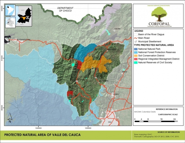
Figure 1. Map of the country and case study region. General location of Dagua River Basin and its protected areas.
| Size of case study/project area 1 | 4500 hectares |
| Number of direct beneficiaries 2 | 280 persons |
| Geographic coordinate (longitude and latitude) |
3º 20’ a 3º 53’ N y 76º 22’ a 77º 05’W |
| Dominant ethnicity | Farmers |
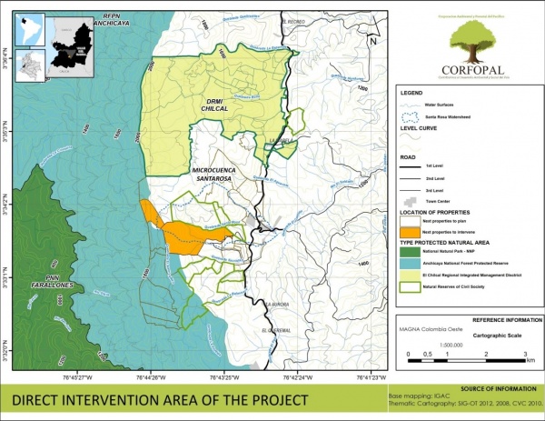
Figure 2. Land use and land cover map of case study site.
Introduction
The processes of appropriation and transformation of natural resources through human development to satisfy development needs and desires (Toledo 2008) has generated the gradual depletion of ecosystem services, reaching the upper limits of the load capacity of the planet (Vásquez & Serrano 2009). The forms of intrusion into ecosystems and subsequent environmental degradation have varied over time and have been influenced by cultural systems, social organization and economic bases, as well as by variables of the environment, such as biotic and abiotic factors and their complex relationships.
The conversion of forest areas into pastures, farming areas or urban centers is a worldwide problem that is intensifying due to the exponential growth of the human population and the consumerism in which today’s society lives (Ehrlich & Ehrlich 2002), resulting in the simplification of ecosystems (Kareiva & Marvier 2011). This alteration of ecosystems and loss of vegetation cover has implications on the landscape and the natural dynamic equilibrium (Roda et al. 2003; ed. Rangel 2004), ecosystem services (Kareiva & Marvier 2011), local and global extinction of flora and fauna species (Turner 1996; Kattan 2002; Kattan & Murcia 2003) and total or partial loss of lifestyles and functional ecology of communities (Angelsen et al. 2011).
Concern over these problems seems to be a recurrent phenomenon in societies throughout history, as suggested by the emergence of independent control practices and responses to this problem on different continents (Meffe et al. 1997). These practices have, in most cases, translated into public and/or private spaces created for the maintenance of biodiversity for in situ conservation of ecosystems and natural habitats (Kareiva & Marvier 2011) that are set aside as protected areas.
According to the IUCN’s World Commission on Protected Areas, a protected area is “a clearly defined, recognized, dedicated and administered geographical space, through legal or other similarly effective means, to achieve the conservation of nature with its associated ecosystem services and cultural values”. In these areas, different actors and their respective plans and priorities that respond to particular objectives and goals (Elbers 2011) converge, generally in a disjointed way. This had led to division among policies and actions, which in many cases has resulted in habitat loss, invasion of territories or abandonment. This is worrying considering that Protected Areas form the central axis in practically all conservation strategies nationally and internationally (Elbers 2011).
In addition, protected areas face a series of external threats, such as climate change, irresponsible tourism, development of infrastructure within and outside them, increasing use and exploitation of natural resources (e.g. mining, logging) and many other threats that challenge conservation (Kareiva & Marvier 2011). In view of the above, it is essential to find a balance between the participation of various actors and those affected by protection actions in protected areas, maintain clear conservation objectives and articulate the issues surrounding the protected areas and the intrinsic needs of the territories where they are located (Maza, Cadena-González & Piguerón 2003; Elbers 2011; Kareiva & Marvier 2011).
The total surface area of terrestrial and oceanic protected areas on the planet has increased. According to the release of the World Database on Protected Areas (WDPA 2018), the total number of protected areas as of June 2018 was 234,793. This increase was made possible thanks to Target 11 of the Aichi Biodiversity Targets, which aims by 2020 for at least 17 per cent of terrestrial and inland water areas and 10 per cent of coastal and marine areas to be conserved through effectively and equitably managed, ecologically representative and well-connected systems of protected areas. Despite this fact, many areas of critical importance to the conservation of biological diversity and ecosystem services are outside this system of protected areas (Elbers 2011). In addition, there are fewer public areas to declare new protected areas; therefore, it is essential to consider other strategies for conservation on private lands.
According to González and Martin (2007), there are various tools for conservation on private lands. The most commonly employed are the creation of private reserves, conservation easements, lease contracts, loan agreements, conservation and usufructs, conservation trusts and purchase of land for conservation. The selection of tools depends on various factors: i) existence of necessary regulations; ii) recognition or lack thereof by the state; iii) economic compensation; and iv) use and times of restriction on the land, among others. Whatever the tool used, there must be a monitoring of compliance with the agreed restrictions on the property (González & Martin 2007).
There are three types of private reserves: i) private natural reserves, which are in fact private farms on which the owners willingly conserve some or all of the natural resources present on the property. This type does not require any procedures or regulations, which is an advantage, and does not have any kind of recognition by the government. Their main disadvantage is that they are not appropriate for long-term conservation because they are totally dependent on the owner’s will. Next, there are ii) private nature reserves recognized by the government, which are private farms with voluntary conservation purposes similar to the private nature reserves, but officially recognized by the government. The advantage of this type of reserve is that it is appropriate for medium and long-term conservation planning; however, the disadvantage is the cost and time required for establishment. Lastly, there are iii) private natural reserves recognized by NGOs, which have advantages and disadvantages similar to the reserves recognized by the government. In some countries, NGOs have programs or networks through which interested owners or farmers obtain recognition of their farms as private natural reserves (González & Martin 2007).
Colombia was the first country in Latin America to achieve recognition of the Natural Reserves of Civil Society within its management categories, recognized in the National System of Protected Areas (SINAP). Furthermore, to accomplish the objective of conservation of biodiversity and ecosystem services, these private initiatives act as connectors between other protected areas, buffer areas for anthropogenic impacts, and contribute to increasing knowledge on the territories and building the social fabric to strengthen community self-management processes for conservation (Ocampo-Peñuela 2010).
The main objective of the case study described herein is to present a summary of the conservation actions implemented in the MDRB, where nature conservation was linked to the improvement of human well-being by developing a participatory process of intervention in favour of improvement of the environment, sustainable production and the promotion of private conservation. Likewise, the participatory management associated with the conversion of private farms or land into natural reserves of civil society (NRCS) is shown as a strategy to guarantee the sustainability of natural resources.
Description of the Dagua River basin region
The Dagua River Basin (DRB) is located to the west of the department of Valle del Cauca in south-western Colombia (3°32’0’’ N, 76°45’27’’ W; 3°36’4’’ N, 76°45’27’’ W; 3°32’0’’ N 76°41’23’’ W; and 3°36’4’’ N, 76°41’23’’ W) (see Fig. 1), with approximately 140,121 hectares, of which 57,220 hectares corresponds to the municipality of Dagua (40.83% of the total area of the basin) (CVC 2003). The Dagua, the main tributary of the area, drains into the Pacific Ocean and presents an equilateral triangle shape.
The basin is divided physio-graphically into the Upper and Lower Part, regions well differentiated by their biophysical and socio-economic characteristics. The upper part has an area of 86,351 hectares, equivalent to 62% of the total area, distributed in eight sub-basins and five micro-basins. It corresponds to the lower part with an area of 53,771 hectares, equivalent to 38% of the total area, distributed in twelve sub-basins and one micro-basin. The middle zone of the Dagua River Basin comprises the confluence of the Bitaco, Grande and Sabaletas rivers to the east and the foothills of the Western Cordillera to the west (Vargas 1998).
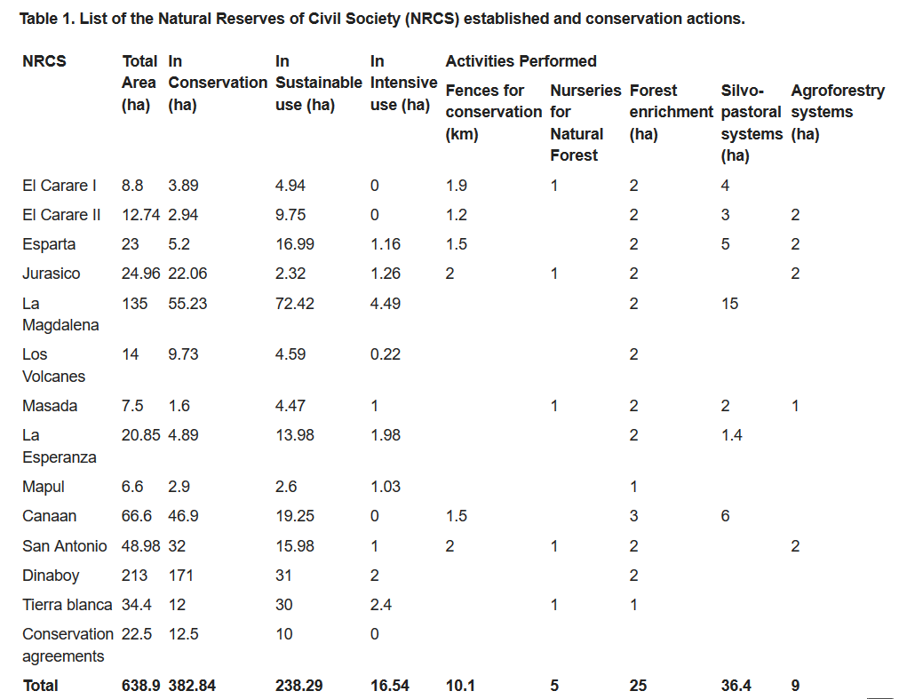
There is currently a network of protected areas in the region: Farallones de Cali National Natural Park (NNP, the highest category of conservation in Colombia), three National Forest Protection Reserves (Anchicayá, San Cipriano and Dagua), two Integrated Regional Management Districts (IRMD—Chilcal and Atuncela) and the District of Soil Conservation of the Rio Grande (see Fig. 3 and 4). Currently, these conservation units work as isolated islands under different (and ineffective) management schemes, besides being highly populated and transformed. The strengthening of biodiversity conservation is needed in the region, especially for the three different ecosystems of great importance: the tropical rainforest (henceforth TRF), tropical dry forest (henceforth TDF), and sub-xerophytic forest located in the Dagua river canyon. The TDF and sub-xerophytic forests are among the most threatened ecosystems in Colombia, designated with a critical status (WWF 2013; eds. Pizano & García 2014).
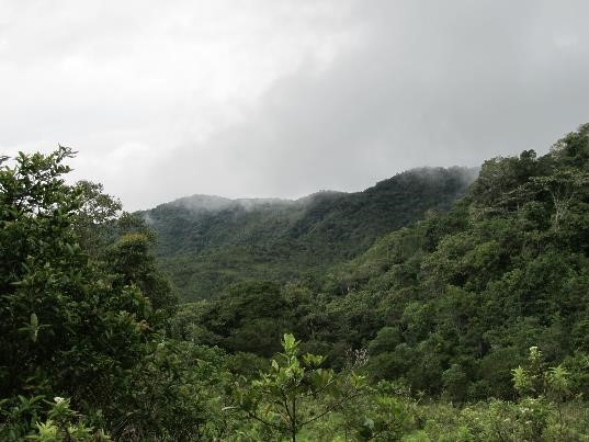
Figure 3. Conservation Area La Española Watershed in IRMD Chilcal (Photo:Sebastian Orjuela)
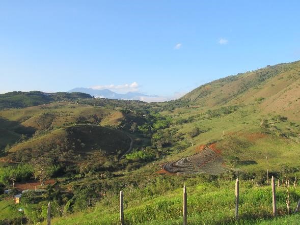
Figure 4. Productive Landscape of Chilcal Village (Photo: Sebastian Orjuela)
Socio-economic characteristics of the area
The main human settlements in the area are the Dagua municipality and its surrounding villages. Dagua is located at 828 m above sea level and has an average temperature of 25°C. It is characterized by abundant summits, where the three ecosystems named above merge and give place to the many basins and micro-basins of the region. The Dagua municipality has 923 km2 of surface area and more than 36,000 inhabitants. According to the Territorial Order Basic Plan and the Municipal Educational Plan of 2008-2011, about 35.3% of the population is in a poverty situation, and the unemployment rate is 20%.
The main productive activities in the region are agriculture, cattle raising, poultry farming, pisciculture, mining, and tourism. These activities are benefited by the diversity of climates present in the wider region. In the case of Dagua, the main economic activity is agriculture, especially pineapple farming that presents a high production and quality. Other crops are tomato, cacao, banana, coffee, papaya and citrus fruit. Due to the various historical processes of settlement and land use, today this area has landscapes with a dynamic mosaic of habitats and land uses that includes villages, farmlands, forests, grasslands and private recreational farms. The landscape has been shaped over the years as a result of the interactions between people and nature in ways such that the high biodiversity present in natural relicts provides the inhabitants of the region with the ecosystem services necessary for their well-being. Therefore, we consider the MDRB to be representative of socio-ecological production landscapes and seascapes (SEPLS) (UNU-IAS, Bioversity International, IGES & UNDP 2014), which have been demonstrated as sustainable landscapes with cultural and natural heritage, that can be managed for conservation.
The threats
The main threats and pressures that ecosystems and biodiversity in general face in the MDRB region are landscape transformation and fragmentation and loss of natural cover and ecological structure. These pressures have led to habitat deterioration for the local biodiversity, as well as to the isolation of populations, the demotion of soils (leading to erosive processes), and hence the alteration of hydric regulation processes. All of this is related directly to the changes in land use that have led to permanent deforestation.
The main driver of these changes in land use is the expansion of the agricultural frontier that has led to the cutting of natural forest to establish crops or pastures to feed livestock. There is also the selective logging of timber species, due to the high demand of timber. The transformation of forest into pastures has increased soil erosion, especially in areas close to the MDRB. There are reports of deep canyons with reddish and compact soil, which are partially a result of extensive livestock keeping.
The hydric systems also suffer from these pressures, facing a decline in water quality, decrease of water flow, and loss of protective plant cover. This decline has led to habitat deterioration and alteration of hydric regulation processes. Likewise, water quality has been affected by the use of chemical pesticides and agrochemicals, inadequate disposal of solid residues, and livestock keeping. There is also mining for artisanal clay in the areas of wet forest, an activity that contaminates hydric sources with the leachate.
Description of activities
Data collected since 2013 indicate the relevance of the ecosystem services offered by the MDRB to the agricultural processes in the region and human well-being (CORFOPAL 2013); however, a lack of financial resources inhibits conservation actions in this agricultural landscape. In response to this problem, we have worked with the MDRB community, with the objective of linking nature conservation with the improvement of human well-being, by developing a participatory process of intervention in favour of the improvement of environmental, sustainable agricultural production and the promotion of private conservation with the establishment of Natural Reserves of Civil Society (see Fig.2).
Natural Reserves of Civil Society (NRCS)
The Natural Reserves of Civil Society is an initiative for the conservation of biodiversity and natural resources on private property. The NRCS is the only legal privately protected area in Colombia and is part of the National System of Protected Areas (SINAP). In order to have a property registered as an NRCS, it must comply with legal and other technical requirements. In the legal framework, the property must guarantee the real and effective possession of the real property by public deed and certificate of tradition. For the technical component, the property must conserve a representative sample of the natural ecosystem and manage the use of natural resources under the principles of sustainability, excluding industrial exploitation of timber and allowing only sustainable exploitation of wood for domestic use.
Once technical and legal feasibility have been verified, a series of steps must be completed to carry out the registration, ranging from filling in the registration form, reviewing the legal documentation of the property, and development of the zoning map of the farm, to the filing of the documentation before the national natural park unit of Colombia. Depending on the volume of requests, this process can take between four to six months.
For those cases in which the property does not meet the legal and/or technical requirements, a conservation agreement is signed. This agreement is a voluntary understanding between the owners and an NGO, where the owners commit to conserve the forests on their farm and to maintain sustainable production practices in exchange for the technical accompaniment and the implementation on their farms of conservation actions (e.g. fences for conservation, forest enrichment, silvopastoral systems and irrigation for pastures) by the NGO.
Among the benefits of registering as an NRCS are: rights of participation in the planning processes of development programs; prior consent for the execution of public investments that affect them; the right to conservation incentives that are managed through programs and projects; and other participation rights established by the law.
Property planning and agreement with owners
Once the NRCS has been established or the conservation agreement signed, a basic biophysical and socio-economic descriptive diagnosis is made, with emphasis on economic activities, family needs, and the technical requirements of land use and sustainability for the current state of biodiversity. Subsequently, a zoning of the property, agreed upon with the owners, is made using the base cartography of the area. The areas to be conserved and restored are defined, along with the landscape management tools and productive systems to be implemented, according to the potential land use and planning instruments that contribute to habitat improvement and conservation. With this information, the management plan and the monitoring system are established.
Training workshops and awareness campaigns
The local community in the MDRB has inhabited the region for several generations, which has led to a body of traditional knowledge linked to the cultural heritage of the people. We must recognize that these communities keep a repertoire of ecological knowledge that usually is local, collective, diachronic and holistic. This is the result of the close relationship these farmers have with nature and the way they have used and profited from it, which has allowed the development of cognitive systems on their own resources that are passed down from generation to generation orally. This knowledge has been lost due to the invasion of new technologies, the use of chemicals and the little interest that young people have in traditional farm work.
In this sense, as part of the participatory process of intervention through workshops and awareness campaigns, we sought to recover this knowledge and start employing it again, because these traditions are usually associated with the diversified and rational use of natural resources in agricultural production, which gives it resilience to future environmental changes. Because activities on the farms are heavily linked to and sometimes determined by gender, the seminars targeted each gender and their associated tasks in the process of counterclaim, restoration and conservation, as well as in the search of more environmentally-friendly economic activities. Consequently, capacities were built in the community and among other local actors in the areas of responsible consumption and production and the importance of sustainable of ecosystem services, as well as in the conservation of biodiversity and actions that minimize and avoid its loss.
Results
CORFOPAL have registered 13 NRCS and signed 20 conservation agreements with private owners (Table 1), achieving a corridor of 638.9 ha that links private owners with protected areas and contributes to the conservation of the high biodiversity reported in the region (261 species of flora, 102 species of resident birds, 26 species of amphibians and reptiles and 27 species of mammals). Moreover, participation by the community in conservation activities and respect for the environment have improved. People living in the area (reserve owners or not) are more aware and committed to sustainable production practices, enabling them to be more independent and have better opportunities in the ever-growing green market. The actions carried out on these farms correspond to the implementation of landscape management tools for conservation purposes and the reconversion of productive systems through sustainable technologies seeking environmental sustainability without diminishing the economic income of the landowners.
Activities for sustainable production and conservation of biodiversity and ecosystem services
Fences for conservation
Protective isolation is a very effective landscape management tool to carry out natural regeneration processes, the recovery or maintenance of the natural riparian cover on the properties and to prevent the entry, mainly of livestock, and to allow the natural succession. To date, we have implemented 10.1 km of protective isolation on the margin of streams, protected forest strips and other areas of interest for conservation, resulting in the protection of more than 100 hectares of natural areas. Each kilometer of insulation was made with posts buried at 40 cm located every 2.5 meters, also taking advantage of trees as live poles, and with three wires of 12.5-gauge barbed wire, leaving an average minimum height above the ground of 1.60 m, to ensure the durability and effectiveness of the fence.
Nurseries for natural forest material production
Five trees nurseries have been constructed in order to produce plant materials required in the implementation of landscape management tools, as defined in the framework of the process. The planting materials are used for enrichment actions in areas with natural coverage in the MDRB. Among the actions carried out in the nursery were the necessary adaptations to function as a nursery, including adapting a structure for high tables upon which the available material could be easily and comfortably handled. In the nurseries, bio-fertilizers, humus and compost are also produced. For the humus, beds were built with an approximate area of 64 m2, in which there is California red worm cultivation in constant production. For composting, three spaces were determined for cutting material, cow dung and nutritious broths. So far, 900 m3 of earthworm humus and 1,000 m3 of compost manure have been harvested. Organic matter is contributed both to the nursery production and in planting of plant material, both in the areas of enrichment and in the sowing carried out around the mixed fences.
Forest enrichment
With this landscape management tool, a total of 25 ha was planted with more than 3,000 trees. It is important to note that for this enrichment, planting was undertaken using native and timber species mostly produced in the nurseries implemented in the farms. The goal of this activity was to enrich the natural coverage that protects the streams in the reserves and accelerate the process of natural recovery of degraded areas, in order to restore the riverbank forest with the presence of TDF species, contributing to the preservation of the soil, retention of sediments, creation of food to the fauna present in the area and provision of ecosystem services.
Silvopastoral systems and irrigation for pastures
The main economic activity in the area has always been extensive livestock keeping. It was decided with the owners not to change this productive activity, but to improve upon it to make it more efficient and profitable. This, in turn, would allow us to carry out conservation processes to maintain not only the natural resources of the area, but also the quality of livestock kept. Therefore, the process of livestock reconversion with a silvopastoral system was carried out, divided with mixed fences and improvement of pastures, to allow degraded areas to recover and to preserve the existing forest relicts.
In an area of 36.4 ha, seven silvopastoral systems have been established. Additionally, three km of new mixed fences were implemented as divisions for the adaptation and improvement of 1.43 km with the same technical characteristics of the protective isolations, using native species such as Chagualo (Clusia multiflora) and Cucharo (Myrsine guianensis), associated with forage species, including mainly Nacedero (Trichanthera gigantea), and also mulberry (Morus alba) and Matarratón (Gliricidia sepium), to contribute to conservation and connectivity. With the implementation of an irrigation system, more efficient water management was achieved, avoiding waste and maintaining quality throughout the supply process in silvopastoral and other improvements and interventions made.
Agroforestry systems
Agroforestry systems consist of associating trees with established crops, which improves the development of plantings especially in dry or hillside areas, hence generating benefits such as the reduction of damage caused by wind and water (erosion) and maintenance of humidity in the soil that supports the growth of crops during drought. Furthermore, agroforestry improves the soil’s physical conditions, especially the structure, among many other benefits. In this process, nine hectares of agroforestry systems were implemented on five farms, whereby 375 forest trees and 125 fruit trees associated with medicinal species, such as Citronella (Citronella silvatica) and Calendula (Calendula officinalis), were planted. The planting was undertaken using humus produced in earthworm nurseries as input of organic matter.
Lessons learned and conclusion
The presence of public protected areas and private conservation initiatives are an adequate strategy, but not enough to support landscapes and conservation initiatives. For greater effectiveness of interventions under a territorial approach, it is essential to consider the different forms of land ownership in the target areas, and to find a balance between the needs of people and of the protected areas. Hence, the success and sustainability of conservation actions are closely related to the potential for establishing consistent and lasting points of contact with the various actors involved, based on a better understanding of their perceptions, knowledge and the rationality that guides their practices and decisions. Likewise, it is important to establish participatory strategies with the community in order to build management initiatives.
The support to private conservation initiatives in critical places within the basin has strategically served to strengthen the protection of the entire territory and improve the quality of life of its inhabitants. For example, the Santa Rosa micro-watershed, which supplies water to two aqueducts and more than 800 families, has improved water quantity and quality after the establishment and subsequent management of the Carare I and Carare II NRCS (see Fig.5 and 6). Consequently, private conservation initiatives, recognized or not by the government, can be very useful to consolidate or generate strategic corridors within the landscapes of the DRB and can serve as connectors of protected area networks.
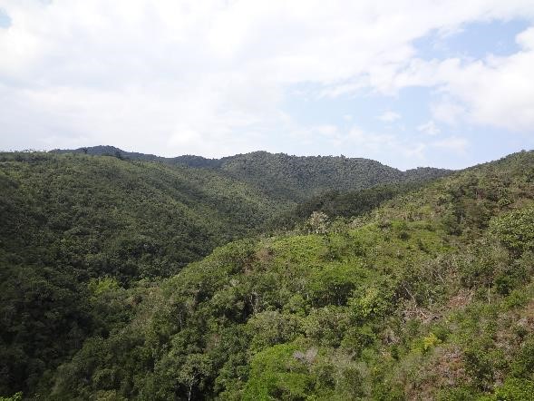
Figure 5. Santa Rosa Watershed_San Jose del Salado (Photo: Sebastian Orjuela)
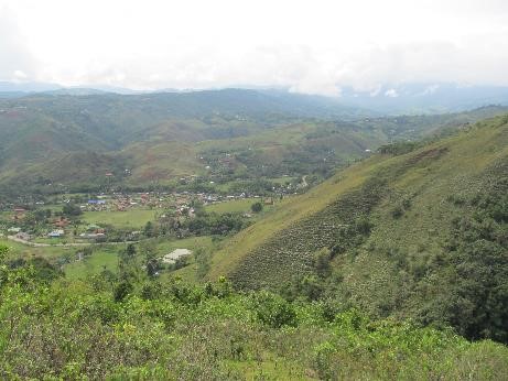
Figure 6. Panoramic view of San Jose del Salado from RNSC Carare (Photo Sebastian Orjuela)
The landscape management actions should be monitored periodically, involving stronger social processes that allow the implemented actions to have continuity, especially when committed community members are involved. In this way, the community and their leaders would be aware of the achievements obtained and could therefore replicate the results.
The implementation of landscape management tools in the area of direct influence of the MDRB will in the short and medium term generate a dynamic of connectivity and increase the necessary conditions for biodiversity conservation in the dry forest and provision of ecosystem services. In addition, the implemented silvopastoral systems in pasture land areas will allow better management of the livestock, while the consolidation of liberated areas of forest will contribute significantly to the main ecological structure of the territory.
The restoration processes require the establishment of a monitoring scheme for the actions involved at every successional stage to cut the costs of interventions. The restoration should be considered a research process that allows knowledge to be applied to tropical dry forest restoration processes and not be an isolated initiative.
The agreements made with the landowners were only possible insofar as a constant accompaniment is carried out, where the exchange of knowledge and feedback are the basis for achieving the implementation of actions that reconcile the different dynamics of the property and its natural environment in favour of the conservation of ecosystem services and biodiversity.
There is great diversity of experience in the management of the NRCS, in different social, political, cultural and economic contexts in the MDRB. This allows us to deduce that it is essential to integrate public and private actors to conserve territories with fragmented but strategic ecosystems, a high percentage of which are vulnerable and in private hands.
It is imperative to involve new generations in the territory, including the school community and new inhabitants that are usually disregarded due to their lack of in depth knowledge on the conditions of the environment or because they are traveling in the territory (tourists). This involvement is important because the new generations are not interested in the field, and they do not understand the importance of conservation of the ecosystems and the traditional knowledge associated with them.
Finally, participation is milestone in this type of process. Thus, individuals, academia and civil society in general must actively participate and contribute to the formation and development of the national system of protected areas, in the exercise of their rights and in compliance with their constitutional duties.
Natural Reserves of Civil Society (NRCS) contribution to the Aichi Target 11
The Natural Reserves of Civil Society complement state conservation efforts and provide an important alternative in community work and the formation of conservation nodes on private lands that favour participation in state decisions. They also facilitate monitoring actions in public areas and become strategic actors of conservation actions in the region, especially when the conservation needs are on private lands. They are protected areas of the national order; therefore, they add to the achievement of conservation goals of the state, contributing significantly to Aichi Target 11. The last report of the National Registry of Protected Areas for Colombia (RUNAP 2018) of July 2018, indicates that there are 654 NRCS in Colombia, totalling 116,317.76 ha in 25 of the 32 departments, which corresponds to 0.7% of the total protected areas in the country. It is a conservation figure that does not exist in other countries; therefore, NRCS tend to be presumed to be Other Effective Area-based Conservation Measures, or OECMs. However, the NRCS are classified according to the IUCN as category VI, “protected areas with managed resources”. The NRCS could be the best managed protected areas in the country. Where many of Colombia’s ecosystems are being radically transformed, one way to prevail is for communities or families to participate individually to restore and conserve ecosystems from their private lands.
Acknowledgments
We are grateful to the landowners who were committed to the conservation of this important area, with the Corporación Autónoma Regional del Valle del Cauca (CVC) for financial support and to Emilio Díaz-Varela, Chemuku Wekesa, the IGES Team and the SITR4 editors team for the final revision of this document.
References
Angelsen, A, Larsen, HO, Lund, JF, Smith-Hall, C & Wunder, S 2011, ‘Why measure rural livelihoods and environmental dependence?’, in Measuring Livelihoods and Environmental Dependence, Methods for Research and Fieldwork, eds A Angelsen, HO Larsen, JF Lund, C Smith-Hall & S Wunder, Earthscan, London, pp. 1-15.
Corporación Autónoma Regional del Valle del Cauca (CVC) 2003, ‘Identificación de Áreas Prioritarias para la Conservación de Cinco Ecorregiones en América Latina’, GEF/1010-00-14 Ecorregión Chocó – Darién, Panamá – Colombia – Ecuador, Centro de Datospara la Conservación, Colombia.
Corporación Ambiental y Forestal del Pacifico (CORFOPAL) 2013, ‘Aunar esfuerzos técnicos y económicos para Contribuir al establecimiento de Reservas Naturales de la Sociedad Civil en bosque seco de la cuenca del río Dagua en los municipios de Dagua y la Cumbre, Valle del Cauca’, Convenio de Asociación No. 017 de 2013, Santiago de Cali, Corporación Autónoma Regional del Valle del Cauca, CORFOPAL.
Elbers, J (ed) 2011, Las áreas protegidas de América Latina: Situación actual y perspectivas para el futuro, UICN, Quito, Ecuador.
Ehrlich PR & Ehrlich AH 2002, ‘Population, development, and human natures’, Environment and Development Economics, vol. 7, pp. 158–170.
González, AM & Martin, SA 2007, Iniciativas Comunitarias de Uso Sostenible de los Recursos Naturales en las Áreas Protegidas: Experiencias del Programa Parques en Peligro en Latinoamérica y el Caribe, Serie Innovaciones para la Conservación del Programa Parques en Peligro, The Nature Conservancy, Arlington, VA.
Kareiva, PM & Marvier, M 2011, Conservation science: Balancing the needs of people and nature, Roberts and Company, Greenwood Village, Colorado.
Kattan, GH 2002, ‘Fragmentacion: patrones y mecanismos de extinción de especies’ in Ecología y Conservación de Bosques Tropicales, eds MR Guariguata & GH Kattan, Ediciones LUR, Costa Rica.
Kattan, GH & Murcia, C 2003, ‘A Review and Synthesis of Conceptual Frameworks for the Study of Forest Fragmentation’, in How Landscapes Change, eds GA Bradshaw & PA Marquet, Ecological Studies, vol. 162, Springer-Verlag, Berlin and Heidelberg, pp. 183-200.
Maza, J, Cadena-González, R & Piguerón, C 2003, Estado Actual de las Áreas Naturales Protegidas de América Latina y el Caribe (Versión Preliminar), PNUMA.
Meffe, GK, Carroll CR & Contributors 1997, Principles of Conservation Biology, Second Edition. Sinauer Associates, INC Publishers, Massachusetts, USA.
Ocampo-Peñuela, N 2010, ‘Mecanismos de Conservación Privada: una opción viable en Colombia’, in Colombia 2010, ed La Imprenta S.A..
Pizano, C & García, H (eds) 2014, El Bosque Seco Tropical en Colombia, Instituto de Investigación de Recursos Biológicos Alexander von Humboldt (IAvH), Bogotá DC, Colombia.
Toledo, VM 2008, ‘Metabolismos rurales: hacia una teoría económica-ecológica de la apropiación de la naturaleza’, Revista Iberoamericana de Economía Ecológica, vol. 7, pp. 1-26.
Rangel, JO (ed) 2004, Colombia diversidad biótica IV, El Chocó Biogeográfico/Costa Pacífica, Universidad Nacional de Colombia, Bogotá, DC.
Roda, J, Franco, AM, Baptiste, MP, Múnera, C & Gómez, DM 2003, Manual de identificación CITES de aves de Colombia, Serie de manuales de identificación CITES de Colombia, Instituto de Investigación de Recursos Biológicos Alexander von Humboldt y Ministerio de Medio Ambiente, Vivienda y Desarrollo Territorial, Bogotá, Colombia.
RUNAP 2018, Registro Único Nacional de Áreas Protegidas de Colombia en cifras, Latest version July 2018, <http://runap.parquesnacionales.gov.co/cifras>.
Turner, IM 1996, ‘Species Loss in Fragments of Tropical Rain Forest: A review of the evidence’, Journal of Applied Ecology, vol. 33, pp. 200-209.
UNU-IAS, Bioversity International, IGES & UNDP (2014), Toolkit for the Indicators of Resilience in Socio-ecological Production Landscapes and Seascapes (SEPLS).
Vásquez VH & Serrano, MA 2009, Las Áreas Naturales Protegidas de Colombia, Conservación Internacional, Colombia y Fundación Biocolombia, Bogota, Colombia.
Vargas, W 1998, Flora del Enclave Subxerofítico del Río Dagua, Corporación Autónoma Regional del valle del Cauca.
WDPA 2018, ‘Latest version June 2018 update of the World Database on Protected Areas’, <https://protectedplanet.net/c/monthly-updates/2018/june-2018-update-of-the-wdpa>.
WWF 2013, ‘South America: in the Cauca Valley of western Colombia’, <http://www.worldwildlife.org/ecoregions/nt0207>.