Community Forest Restoration for the Integrated Management of Lake Chapala Basin

22.03.2012

  • SUBMITTED ORGANISATION :

  • International Lake Environment Committee Foundation (ILEC), and Corazon de la Tierra A.C. (Heart of the Earth), Mexico

  • DATE OF SUBMISSION :

  • 22/03/2012

  • REGION :

  • Central America

  • COUNTRY :

  • Mexico (Lake Chapala Basin)

  • SUMMARY :

  • A model of community forest management was structured at the Lake Chapala basin (Mexico), which has been applied under real conditions since 2002 with 11 rural communities. It consists of six modules, all interrelated and complementary: 1. Organization strengthening, 2. Forest improvement, 3. Agricultural improvement, 4. Livestock improvement, 5. Productive alternatives, 6. Ecotechnologies. Each module has been monitored and systematized, using a set of indicators defined at the beginning and refined along the process. The most important module is Organization strengthening, from it derive all other modules. Until now a set of 11 land management plans has been prepared, which led to structuring and applying of over 60 projects in forestry (reforestation, soil conservation, pest control, fire prevention, payment of environmental services), research (GIS, biological inventories, ethnobotany), alternative production (family orchards, medicinal plants, cultivation of nopal and pitaya, agroforestry, organic agriculture, ecotourism), eco-technologies (rainwater catchment, biodigestors, dry toilets, firewood-saving stoves) and organizational strengthening (creation of community regulations, sharing of experiences and creation of working groups). The package of projects has benefited 7,000 people, now working integrated in a common institution (Community Board).

  • KEYWORD :

  • Forest management, community development, integrated basin management

  • AUTHOR:

  • Alejandro Juarez Aguilar Fields of expertise: Environmental education, community development, integrated basin management, conflict solving approach with 25 years of experience in rural and urban areas Rene Velazquez Moreno Fields of expertise: Community development, forest management, eco-technologies, environmental services with 20 years of experience

Introduction

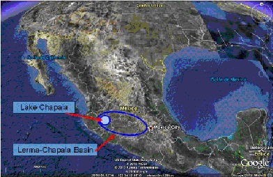
The Lake Chapala basin includes the water body of same name, the largest one in Mexico and the third in size in Latin America (Figure 1). Most of forest ecosystems at the basin present degraded areas derived of land use change, erosion, overgrazing and forest fires. This situation has resulted in water table lowering, reduced soil fertility and loss of biodiversity, which as result has generated reduced agricultural production and increased levels of poverty, altogether with associated problems such as migration. According  to data reported by the National Commission of Water and independent researchers (Juarez et al., 2010)  the phreatic level has decreased dramatically during last 50 years: in 1970 it was common to find underground water at 5 meters (15 feet) deep while now sometimes it’s necessary to drill more than 100 meters  (300 feet) to find it. On the other hand surface runoff has increased, causing flooding and mudslides during the rainy season (May-September).

Lake Chapala basin, together with another 18 basins, composes the Lerma-Chapala basin (a macro-basin of 53,500 km²). This area is characterized by the diversity of ecosystems related to changes in altitude and climate as well as the extent of topographic forms (mountains, plains, canyons and valleys), which in turn has generated a rich biodiversity (Cotler, et al., 2006) and environmental services, quite essential for a population of more than 15 million people dwelling in the basin and 10 million external users. Lake Chapala is permanent, with upward fluctuations during the rainy season and low during the dry season. Although volume has reached beyond its storage capacity (in 1926 reached 122.36% generating severe flooding) has also suffered sharp declines in their level (in 1955 was reduced to 12.08%, while during 2002 fell to 14.4% of it). In general conditions the average depth is 7.7 meters (Guzman et al., 2000).

Figure 1: Location

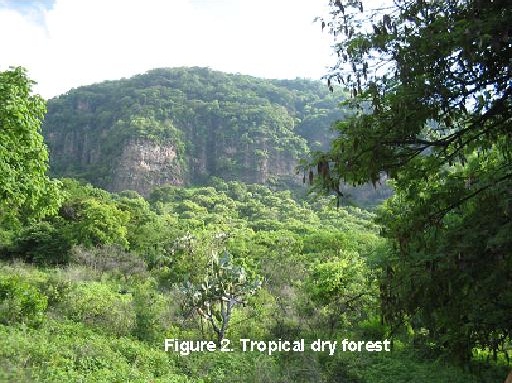
60% of natural vegetation in the watershed is composed by tropical dry forest (Figure 2), the rest is integrated by hardwood and coniferous forest, marshes and other ecological associations, with varying degrees of disturbance. Tropical dry forest it’s an underestimated vegetation type in Mexico, for not being a timber ecosystem. According to Carranza and Montaño (2003) it’s the most threatened and least protected forest ecosystem in the world.  Basin’s biodiversity is high, counting with presence of 43 species under law protection, several endemic. Also there is presence of migratory birds and mammals (bats). Six bird species are included in the North America Waterfowl Conservation Act and eight are of “high priority” for the Western Hemisphere Shorebird Reserve Network.

Figure 2: Tropical Dry Forest

Coincidentally with this high ranked biodiversity there is a strong and diverse use of land for productive uses: irrigated and non-irrigated agriculture, livestock, industry, tourism and commerce, which frequently generate negative effects on environment.

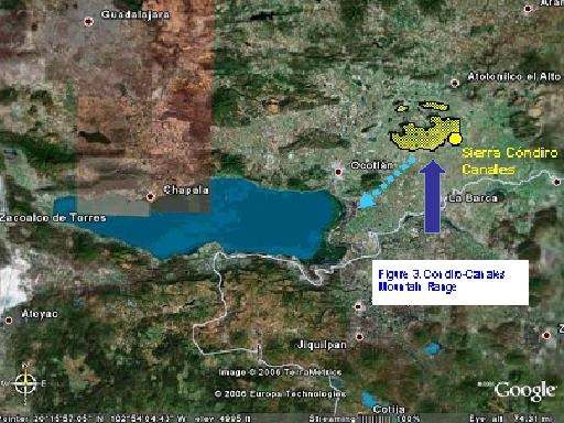
Following the premise that to properly manage a territory is necessary to have a solid governance, reflected  among other aspects  in the participation of local dwellers in the management of local ecosystems, also in the development of networks to promote such bonding process, in 2002 it was launched the Sustainable Development Program of the Condiro-Canales Mountain Range, focused on strengthening local people’s knowledge of  features and condition of the forest area; and strengthen self-management skills and decision making of local people. The program was implemented in 11 towns located in and around the forest zone of same name (Figure 3). Condiro-Canales Mountain Range (CCMR) it´s a forest area of ​​11,000 hectares allocated 20 kilometers northeast of Lake Chapala, which captures 72.1 million cubic meters of water per year, which spreads over 38,000 hectares where about 250,000 tons of agricultural products are cropped each annual cycle. Also this liquid recharges 21 dams, supplies liquid to 17 rural towns and 2 cities, besides bringing provision to Lake Chapala.

Figure 3: Condiro-Canales Mountain Range (CCMR)

In an initial diagnosis with afore mentioned 11 communities there was found: conflicts between inner groups, lack of information about local ecosystems, severe disorganization problems, low-gain productive activities, poorly developed capacity to transform products, dependence of commercial intermediaries, institutional indifference towards the area, low participation of women and youth in decision processes, severe degradation in 30% of forest surface, reduced access to drinking water, overgrazing throughout the area. Also there were a common vision of the forest area as something useless and unimportant.

Using the “Problem Tree” technique, root causes were defined: poor residents’ organization and severe lack of information about how to use local forests in a sustainable way. Using this as initial data (Base Line) the Sustainable Development Program of the Condiro-Canales Mountain Range was structured.

Materials and Methods

This program was defined to be applied in a long term, from 2002 to 2010, including its Structure, Goals, Terms of Reference, Guiding Principles and Methodology.

Goals were defined as: a) to strengthen capacities of community groups, increasing their self-management abilities; b) to improve local dwellers’ knowledge about their territory, c) to promote equity in community access to such resources, through sustainable practices; and d) to achieve a permanent sustainable development process, linked but not dependable of government institutions, universities and civic groups.

The program is based on 10 Guiding Principles: 1) Facilitate the organization and strengthening capacities of communities, 2) promote the use of land based on its natural vocation, 3) strengthening community management and diversified use of natural resources, 4) comply the current legal framework, 5) promote equitable access to natural resources, 6) give priority to productive activities to meet basic needs and integration in local and regional markets, 7) to conduct ongoing research and monitoring, 8) promote multiple mechanisms of financing, 9) count with a facilitating group to provide advice and help decision making process, 10) structure conditions for a coordinated institutional participation in  support of the settlers decisions.

Given the social, ecological and economic context of the region and considering the budget constraints and difficulties of political-administrative nature, it was chosen, using the 10 Guiding Principles, conduct the activities with communities using four methodological criteria, being these Dialogue of knowledge: use both the knowledge of  community groups and the technical advisors, since both are complementary; Use of generative questions, foster generation of answers from participants  to identify problems and solutions, based on the experiences and knowledge of the community; Differentiation of responsibilities: emphasizing that it is the right and obligation of each community to bear responsibility for their own development; Positivization of conflicts: to identify the existence of different points of view and interests, and the constant need of people to organize themselves to overcome difficulties through joint solutions.

Such principles were structured using two psychological theories, constructivism by Jean Piaget (Guzmán, 1993) which considers that knowledge it’s not provided but constructed within each individual and community; and Vygotsky’s theory (Leotiev, 1991), in the sense that learning is a socio-cultural process that considers the particular context of learning as determinant of development. Also during the project were incorporated and/or improved instruments of communication, transparency and accountability.

An advantage of using such methodological criteria instead of fixed methodologies is that with a small but permanent technical group it’s possible to cover a wide range of situations with lower cost than through the recruitment of specialists for each stage of the program (characterization, diagnosis, structuring of work programs, project development, processing and management, implementation, monitoring and accountability). Also the permanence of concrete persons from the technical group is important because linkages with communities require mutual trust, a condition not easily constructed or achieved overnight.

To provide an easy to understand Structure, six modules were defined as described:

Module 1: Organization strengthening: It’s the base of the process. Includes problem identification and ranking, problem-source analysis, reinforcement or creation of legal and administrative structures; decision-making improvement (defining specific responsibilities). Finally, structuring of working projects and plans, including follow-up roles and rules. Derived projects can then be defined to be included in any of the other five modules.

Module 2: Forest improvement: Include restoration, conservation and productive activities such as soil conservation, seeding, forest pest control and prevention, forestry, tree nurseries, payment for environmental services, ecotourism, wild fruit recollection, etc.

Module 3: Agricultural improvement: Include soil conservation activities, training to prepare and use biofertilizers and compost, seed banks, organic agriculture, multi-purpose crops, etc.

Module 4: Livestock improvement: Include health controls, stabling, grazing control and rules, multi-purpose farms, genetic improvement, among others.

Module 5: Productive alternatives: Several non-traditional approaches to include other productive activities or improve those already existing but with low profile: honey production, collecting of wild sweet potatoes, medicinal plants, flowers production and others.

Module 6: Ecotechnologies: Any kind of easy to install and reproduce technology, with low maintenance cost: rainwater catchment systems, biodigestors, dry toilets, solar stoves, firewood-saving stoves, etc. Such technologies must have an easy to perceive positive effect, in order to foster its quick reproduction, preferably with local materials.

Deriving from Module 1 (Organization strengthening) a set of 11 participative management  plans were prepared, which particular needs and priorities had to be assigned  to each one of the other five modules. As a whole, more than 100 specific projects were successfully funded and applied (see next section).

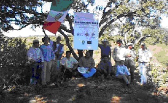
As a complementary field (not directly involving community participation) it was necessary to create “Research activities”, taking into account the small number of documents relating CCMR and the importance of monitoring the process to understand its changes and proceed to adjust the program. As part of this, biology inventories and expeditions were conducted (Figure 4), altogether with social studies.

Figure 4: Researcher Group 2003

Each module has been monitored and systematized, using a set of indicators defined at the beginning (Juarez et al., 2002) and refined along the process. It’s important to mention that he process has been difficult at some moments, given the fact that each of the 11 localities with which the program has been developed comprises within different groups (ejidatarios, private landowners, farmers, cattlers), some of them also related to differences in age and gender (women, youth, children, elderly), several of whom had varying inner degrees of conflict.

At the initial stage it was necessary to identify a key group to work with it, community land owners (ejidatarios, organized as ejido assemblies) was selected due to its direct use of both forest and agriculture areas. However, special attention was paid to create links with other stakeholders through  reporting of progress and results achieved, done in  very precise moments in order to add up allies and supporters, both within each town and with the government, academia and civil society organizations. To allow an appropriate structuring between the groups without losing sight of the primary endpoint (improve the condition of ecosystems and the living conditions of the inhabitants) it was built a multi-stakeholder platform, using methodology proposed by Hemmati (2002).

In 2007 the technical team entered in contact with the Integrated Lake Basin Management (ILBM) approach, which understands governance being composed by six pillars: Information, Participation, Institutions, Policies, Technology and Finance. With the above as a structure and using the Governance Diagnostic System (Juárez, 2011) the set of information collected in the CCMR range during 2002 and 2009 was reviewed to assess progress achieved in terms of governance in this forest region.

Results

After nine years of activities, outcomes reached are these:

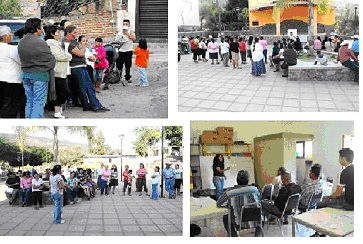
Module 1: Organization  strengthening: 11 community plans were structured and developed, three ejido inner regulations were created, there are five new productive groups (two of them with legal structure), 10 villages count now with Sustainable Committees which interact in the management Board of CCMR (Figure 5).

Figure 5: Organization Strengthening

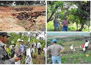
Module 2: Forest improvement: Soil conservation work was done in 800 hectares (retaining 50 thousand tons of soil); 600 thousand forest trees were planted, forest pest has been controlled systematically on 1,800 hectares, 600 hectares count with fire prevention labors, two community areas are receiving payment of environmental services, three tree nurseries have been installed in local schools, an ecotourism management plan was created, covering 2,000 hectares: it is now at first stages of implementation (Figure 6). As part of the process 25 training courses have been provided.

Figure 6: Forest Restoration and Management

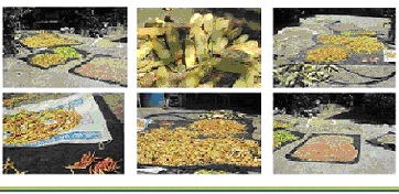
Module 3: Agricultural improvement: 40 family orchards were created/improved, a regional bank of seeds was created, rescuing 23 local varieties (Figure 7); 120 persons learned how to prepare biofertilizers, compost and “mineral soups”, cultivation of nopal and pitaya (local cactuses with high demand) was improved.

Figure 7: Seed recollection

Module 4: Livestock improvement: A series of grazing control and rules have been developed by ejido assemblies; a training course of agro-forestry was provided and 100 hectares are in the process of reconversion for such purposes.

Module 5: Productive alternatives: A medicinal herbarium was created, with a group of women making ointments, creams and soaps; a bakery was installed, another women group started production and distribution of jellies and marmalades. Also 60 family orchards are in operation and an ecotourism group (operated by local people) it’s offering services at the high part of the mountain range.

Module 6: Ecotechnologies: 25 families count with rainwater catchment systems (each one of 5,000 liters), 50 solar stoves were provided, 80 firewood saving-stoves are installed; biodigestors, dry toilets, germinators and solar heaters were installed as demonstrative systems.

Research activities: Two gender studies, two ecotourism potential studies, two ethno botanic studies, one medicinal plants guidebook, five training manuals (bio-fertilizers, orchards, seed conservation, etc.), a GIS and a set of maps; three biological inventories, an scientific expedition, six micro basin management plans and three community land management plans were organized/created.

Comments and Conclusions

Alongside the program a diverse variety of community organization forms were created or strengthened, including ejidos and groups of women, youth and producers. In 2009 10 Committees of Sustainable Development (CSD) were integrated in same number of towns, which articulated themselves in 2011 to form the Bureau of Management for Condiro-Canales Mountain Range. Such form consists of the CSD, supported by a Technical Board (with civil society organizations and universities) and a Government Board (with municipal, state and federal representatives). The Bureau acts as a communication structure to solve common problems and define multi-stakeholders projects.

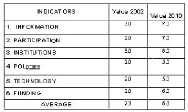
Governance indicators in the mountains rose 273% since the initial stage to date (Figure 8), significantly increasing institutional participation, the level of cooperation between the settlers and the concrete actions of restoration and conservation applied. For the specific of each governance indicator, listed below are shown some of the specific elements. In Institutions, back in 2002 only four government agencies had a presence in the area through projects, such number has increased to 14 in 2010, also on the Board of Management participate government, social and academic sectors in a permanent way; for Information when the project began the only available data for the area was that of demographic nature generated by federal government, currently there are 21 technical studies, two published articles and 4 conference memories as well as a Geographic Information System. Also a majority proportion of the residents currently recognize the importance of forests and are aware that the solution of the problems is their own responsibility (Juarez et al., 2007).

Figure 8: Governance Indicators 2002-2010

The actions carried out in the Sustainable Development Program of Condiro-Canales Mountain Range (2002-2010) have been effective despite conditions of scarcity of funds and materials, as well as difficulties inherent in any community process. However, the approach and method of work has allowed significant advance from the initial stage.

The program has many advantages: it allows rural people to take ownership of their development process to strengthen their organizational structures, helps to establish a solid foundation for democratic processes facilitates informed decision making for management of forest ecosystems and creates linkages to solve conflicts and problems. From strengthening the social structure derives the development of projects to improve social, environmental and productive activities.

At first sight it may seem a slow process but it is actually more effective than short-term actions that are performed in a disjointed way and lose effectiveness as soon as the project that spawned them finish. The commitment of the program is to build social capital with a focus on sustainability, following the 10 Guiding Principles listed before.

The results were systematized for the first time in 2007 and are being revised to strengthen them, providing technical descriptions and diagrams of work process, problems encountered and strategies of solution to build critical paths that allow the application of the model in more effectively ways in other mountainous areas of the Lerma-Chapala basin. The results are successful and feasible to be reproduced in other areas of Lake Chapala basin. In fact, this approach started to be applied in another 10 communities of this watershed since May 2011. We see this as a practical opportunity to involve local dwellers in conservation of the basin and Lake Chapala itself, one of most complex aquatic ecosystems in Mexico.

References and Bibliography

Cotler, H., M. Mazari y J. de Anda. 2006. “Atlas de la Cuenca Lerma-Chapala, construyendo una visión conjunta”. Secretaría de Medio Ambiente y Recursos Naturales, Instituto Nacional de Ecología/Universidad Autónoma de México, Instituto de Ecología. 195 pp.

Guzman, Juan Carlos. 1993. “Implicaciones educativas de seis teorías psicológicas”. UNAM, CONALTE. México, D.F.

Guzmán, M.; A. Valdez y S. Peniche. 2000. “El lago de Chapala, una visión general”. En: Chapala en crisis. Análisis de su problemática en el marco de la gestión pública y la sustentabilidad. A. Valdez, M. Guzmán y S. Peniche. Universidad de Guadalajara. México. 177 pp.

Hemmati, M. 2002. “Multi-Stakeholder processes for governance and sustainability: Beyond deadlock and conflicto”. Earthscan.

Juarez, A. 2011. “A Practical Approach in ILBM Pillar Assesment: An Example”. In: Development of ILBM Platform Process, Evolving Guidelines through Participatory Improvement. RCSE-Shiga University and ILEC. Japan.

Juarez, A., N. Orozco y M. E. Reyes. 2002. “Programa de Desarrollo Comunitario de la Sierra Cóndiro-Canales, Jalisco. Primera fase.” Corazón de la Tierra, A.C./ Comisión de la Cuenca Propia del Lago de Chapala, A.C./Ayuntamiento de Atotonilco El Alto/ Ayuntamiento de Ocotlán, Ayuntamiento de La Barca/ Secretaría de Medio Ambiente y Recursos Naturales. 32 pp.

Juarez, A.; R. Velazquez, L. E. Enriquez, A. Muzlera, J. H. Cano, O. Quintero, L. A. Zarate. 2010. “Componente Ecológico del Programa de Conservacion y Manejo del Sitio Ramsar Lago de Chapala”. Reporte Tecnico de Corazon de la Tierra para la Comision Nacional de Areas Naturales Protegidas y la Secretaria de Medio Ambiente y Desarrollo Sustentable. Guadalajara, Mexico. 144 pp.

Leontiev, A.N. 1991. Artículo de introducción sobre la labor creadora de L.S. Vigotski. En: “Vigotski, obras escogidas”. Editorial Visor. Madrid, España

Recomendations

Arriaga, L., J.M. Espinoza, C. Aguilar, E. Martínez, L. Gómez y E. Loa (Coordinadores). 2000. “Regiones terrestres prioritarias de México” Comisión Nacional para el Conocimiento y uso de la Biodiversidad. México

(http://www.conabio.gob.mx/conocimiento/regionalizacion/doctos/rtp_113.pdf).

Bruner, J. y D. Oslo. 1973. “Aprendizaje por experiencia directa y aprendizaje por experiencia mediatizada”. Perspectivas No. 3 Vol. 1, UNESCO. Madrid, España. pp. 24-30.

Coll, César. 1995. “Constructivismo e interacción educativa. ¿Cómo enseñar lo que se ha de construir?” Ponencia presentada en el Congreso Internacional de Psicología y Educación en Corrientes Pedagógicas Contemporáneas (Antología). México, D.F. pp. 9 a 24.

Cotler, H. 2003. “Degradación de suelos en la Cuenca Lerma-Chapala, México a escala a1:250,000”. Instituto Nacional de Ecología, Secretaría de Medio Ambiente y Recursos Naturales.

Cotler, H. y G. Caire. 2009. “Lecciones aprendidas del manejo de cuencas en México”. Instituto Nacional de Ecología/WWF-Unión Mundial para la Conservación/Fundación Gonzalo Río Arronte. México. 380 p.

De Anda, J. 2006. “Disponibilidad media anual de agua en la cuenca Lerma-Chapala-Pacífico”. En:  Cotler, H.; M. Mazari y J. de Anda (Compiladores) Atlas de la Cuenca Lerma-Chapala, construyendo una visión conjunta. Secretaría de Medio Ambiente y Recursos Naturales, Instituto Nacional de Ecología/Universidad Autónoma de México, Instituto de Ecología. P. 82

Leff, Enrique. 1994. “Sociología y ambiente: Formación socioeconómica, racionalidad ambiental y transformaciones del conocimiento”. En: Ciencias Sociales y Formación Ambiental. E. Leff (compilador). Barcelona, España. Ed. Gedisa.

Rangel, J.L. 2002. “Poder informal e intermediación política en la ribera sur del Lago de Chapala: el caso de Tizapán El Alto, Jalisco”. En: Durán Juárez, J.M.; A. Torres Rodríguez, B. Boehm Schoendube, M. Sánchez Rodríguez. II Encuentro de Investigadores del Agua en la Cuenca Lerma-Chapala-Santiago: Política, tecnología y Sustentabilidad, Pasado y Presente. Universidad de Guadalajara/El Colegio de Michoacán.