Community-Based Woodland Restoration for Livelihoods and Sustainable Wood Fuel Utilisation in the Mole Ecological Landscape, Ghana (SITR8-1)
16.03.2024
SUBMITTING ORGANIZATION
DATE OF SUBMISSION
19/09/2023
REGION
Africa
COUNTRY
Ghana
AUTHOR(S)
Jacqueline Sapoama Mbawine
Godwin Evenyo Dzekoto
LINK
1 Introduction
In Ghana, biodiversity conservation is carried out mainly through nationally designated protected areas and the institution of indigenous traditional measures such as the creation of community sacred groves, reverence of totem animals,1 and the observance of taboo days2 (Adom 2018). The Community Resource Management Area (CREMA) model has been recognised for its role in management of biodiversity on community lands outside protected areas. Outside traditional conservation management methods, the CREMA framework creates a platform on which stakeholders, including both state and non-state actors, can express and negotiate their interests, such as embracing collective values on ecosystem restoration as outlined in this case study.
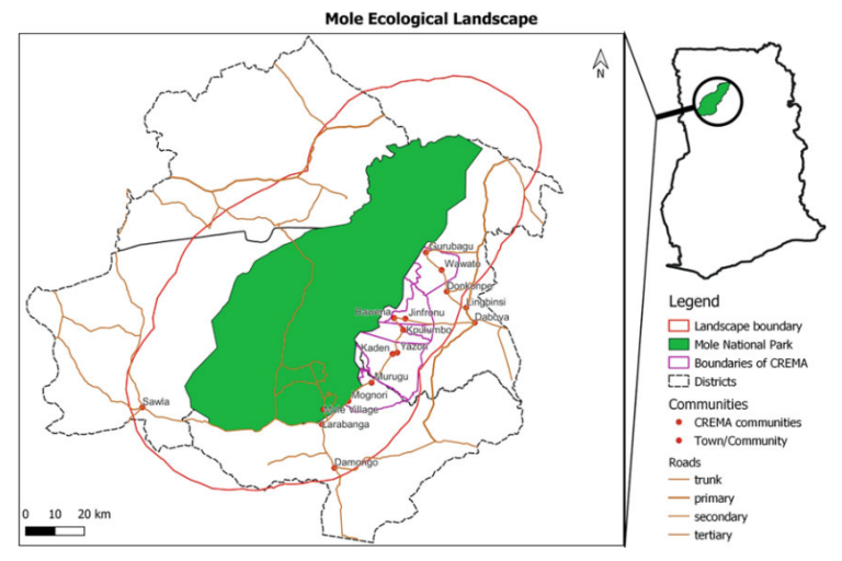
This case study is based on outcomes of the Mole Community-Based Woodland Restoration for Sustainable Wood Fuel Utilisation project developed and implemented by A Rocha Ghana in CREMAs within the Mole Ecological Landscape (Fig. 2.1 and Table 2.1).
The Mole Ecological Landscape is a biodiversity hotspot in the Savannah Region of Ghana that supports a myriad of local livelihoods. However, the landscape faces challenges such as illegal logging, unregulated charcoal production, and bushfires. These challenges threaten biodiversity, contribute to climate change, and undermine the sustainability of community livelihoods. These threats were further intensified between 2003 and 2021 during a spate of increased illegal logging of rosewood, an endangered species listed under Convention on International Trade in Endangered Species of Wild Fauna and Flora (CITES) Appendix II (Obiri et al. 2022; Adjonou et al. 2020; Dogbevi 2020). The project was developed with the aim of engendering sustainable vegetation harvesting practices and sustainable regimes for wood fuel and charcoal production within the Mole Ecological Landscape as a means of addressing the identified landscape challenges. Specific objectives of the project that are relevant to this chapter are to: (1) create awareness and build capacity for the restoration of 500 ha of woodlands using agroforestry, enrichment planting, and assisted natural regeneration approaches; (2) mobilise communities for participatory mapping and planning of restoration activities; and (3) organise and train charcoal producers for a more sustainable charcoal production value chain in the Mole landscape.
Several efforts have been made by the government and traditional authorities to address the landscape challenges, including national bans on rosewood logging (Obiri et al. 2022), traditional bans on commercial charcoal production (Fugu 2018; Adams 2021), and closure of commercial businesses in charcoal and rosewood harvesting (Fugu 2021). However, similar efforts have not been made to restore the degraded landscape of the Mole Ecological Landscape prior to this project (Dogbevi 2020). Although the project period is 2019–2023, the interventions outlined in this case study cover the period of 2019–2021. These interventions are essential contributions to addressing the landscape challenges for maintaining not only the remnant biodiversity, but also conserving the landscape characteristics. The project was funded by the Federal Ministry for the Environment, and Nature Conservation and Nuclear Safety (BMUV) of Germany through the German Development Cooperation (GIZ).
1 Totem animals are not hunted due to their cultural significance.
2 Days on which community members do not go to farm, hunt or fish.
2 Methods
2.1 Case Study Area Description
The Mole Ecological Landscape in the Guinean savannah ecozone is one of the critical biodiversity hotspots in Ghana. The landscape hosts Ghana’s first, largest, and most prestigious protected area, the Mole National Park (Mole National Park 2015). Conservation of biodiversity within the landscape is largely through this nationally designated protected area, which covers approximately 4577 km2 . The park is home to 742 vascular plant species, over 90 mammal species, including five primates, 334 bird species, 33 reptiles, 9 amphibian species, and about 120 butterfly species (Mole National Park 2015). Within the landscape, some wildlife species of conservation concern in the fringe communities include: the caracal (Caracal caracal), common genet (Genetta genetta), bohor reedbuck (Redunca redunca), roan antelope (Hippotragus equinus), Nile crocodile (Crocodylus niloticus), and Nile monitor lizard (Varanus niloticus). Besides the wildlife, tree species of conservation concern include the African mahogany (Afzelia africana) and rosewood (Pterocarpus erinaceus). Economically important trees include the shea tree (Vitellaria paradoxa) and dawadawa (Parkia biglobosa).
The Mole Ecological Landscape has two main seasons, the rainy season (April to October) peaking in June or July with dry spells in August, and the dry season (November to March) (MOFA 2022). The landscape provides a wide range of ecosystem services for communities; key amongst them are agricultural production, ecotourism, and mitigation of climate change impacts. The landscape also supports the livelihoods of over 80,000 community members who are mainly farmers, charcoal producers, beekeepers, or pastoralists (A Rocha Ghana 2020). Another significant livelihood activity within the landscape is the collection and processing of Vitellaria paradoxa (sheanut) into shea butter by the women.
The CREMA model, which was developed by the Wildlife Division of the Forestry Commission of Ghana as a policy intervention for conservation challenges, is aimed at promoting collaborative and participatory wildlife management within communities fringing protected areas in the country (Asare et al. 2013; Forestry Commission 2004). The model, which works as a community-based organisation, principally involves a community or group of communities agreeing on the management of a common resource area. As part of the management system, the CREMA is organised at three levels: the advisory level (CREMA Executive Committee); community level (Community Resource Management Committee-CRMC); and the individual community member or landholder level (Forestry Commission 2004). The development of a constitution and the establishment of relevant by-laws also guide and regulate natural resource governance and management activities in the respective constituent communities (MLNR 2019). Communities also agree to define CREMA boundaries and demarcate their land into three main zones: the core zone, which is biodiversity-rich area for conservation purposes; the buffer zone, where there is limited resource extraction; and the transition zone, where farming and other resource utilisation is allowed (Forestry Commission 2004).
2.2 Interventions in Response to Landscape Challenges
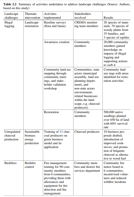
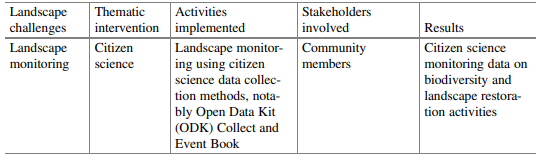
Data for the case study were collected through the various activities implemented by the project to address the identified landscape challenges of illegal logging, unregulated charcoal production, and bushfires. For the purpose of this case study, the activities reflect thematic areas in response to the identified landscape challenges. These thematic areas are landscape restoration in response to illegal logging and other related challenges through biodiversity baseline surveys, awareness creation, community mapping, and restoration activities. Promoting sustainable biomass energy production through training of charcoal producers in green business models was the response to unregulated charcoal production. Bushfire control through fire management training was the response to bushfires. Likewise, promotion of citizen science landscape monitoring was a crosscutting response to monitor and assess the effectiveness of project interventions in contributing to the sustainability of the landscape.
The baseline surveys used transect walks to collect fauna data by recording sightings and animal signs along the transect. Vegetation data were collected through sample plots by assessing floral diversity, presence of rare, threatened, or endangered species, and assessment of natural regeneration species through growth performance. Community meetings were held to raise awareness on landscape biodiversity and its link to sustainable livelihoods. The meetings were also used to discuss the essence of landscape restoration. Community maps were developed using participatory mapping to identify areas that needed restoration. For the purpose of ensuring that restoration efforts did not have a negative net impact on the landscape and native species, the landscape was stratified into four categories based on biodiversity and restoration needs. Appropriate restoration techniques were then applied to provide the best results and a balanced net impact of the restoration efforts on landscape biodiversity. Details of the activities are outlined below.
Biodiversity Baseline Surveys As part of efforts to address the identified landscape challenges, the project sought to establish baselines in the CREMA. These were to serve as the basis for preparation of stakeholder engagement and development of strategies for undertaking restoration activities, which are one of the key focuses of the project. The baseline survey, which covered both flora and fauna, was carried out in August 2020 in five communities participating in the restoration activities. These communities were strategically selected based on their impact on the landscape as a result of resource utilisation. The CREMA was stratified into four main land use categories, namely farmlands, fallow lands, riparian areas, and core zone. A stratified
sampling approach was employed to best select survey sites and to characterise species occurrence and distribution within the four land uses. The fauna survey was carried out by walking a 1–2 km transect per observation period, taking note of species encountered on a data sheet and recording their Global Positioning System (GPS) waypoints. For the vegetation survey, a plot-based vegetation sampling approach was used to sample vegetation communities, floral diversity, and the possible presence of rare, threatened, or endangered species. A GPS was used to record all plot locations and boundaries. The survey also estimated tree density and composition of different species present in the identified land use categories. All-natural regenerating species were identified and counted, and their growth performance was assessed. Seedlings and saplings ≥0.10–1.3 m in height inside the subplots were tallied as regeneration. 18 J. S. Mbawine and G. E. Dzekoto
Awareness Creation Awareness creation and community engagement was carried out by building onto the existing CREMA structure. Awareness creation activities employed methods such as community durbars and village square meetings on pre-agreed scheduled dates. At the meetings, engagement methods included the use of documentaries to showcase conservation advocacy, the importance of conservation, and National Geographic videos, amongst others. These were a prelude to sharing the results of the baseline survey, which served as an entry point to engage community members on the need for restoration activities, as well as the project and its activities. Opportunities for clarifications, questions, and answers were provided as part of getting community members to buy into the project’s proposed actions to address the identified challenges. Community engagement was also used as an opportunity to solicit volunteers who would be willing to participate in implementation of the project interventions, particularly for the restoration activities.
Community Land Use Mapping The project carried out a landscape restoration needs assessment in October 2020 and supported the communities to develop a land use map based on landscape characteristics and land use systems. The aim of the community land use mapping was to identify opportunities for restoration activities. This was a participatory process undertaken first with communities in a community meeting setting, and validated in a workshop setting with the involvement of state and non-state actors and beneficiary communities. Another focus of this activity was to stimulate discussions around sustainable wood fuel harvest and charcoal production.
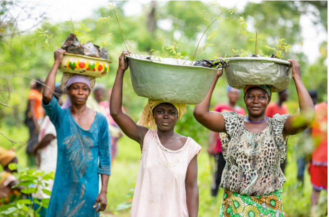
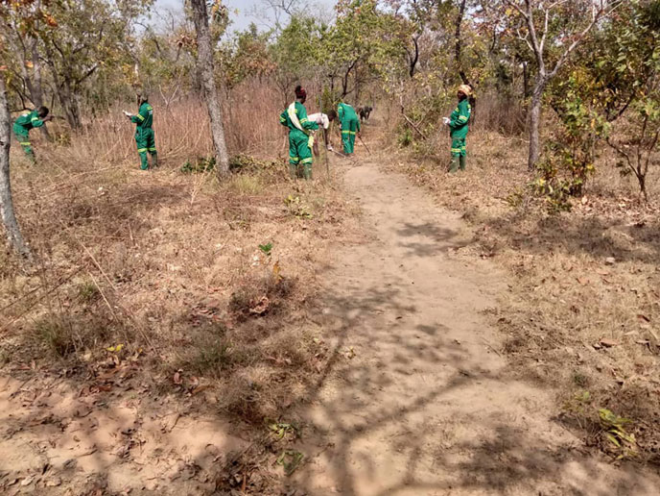
Restoration Activities The restoration activities were based on the results of the landscape restoration needs assessment and the community land use mapping exercises. A community nursery was established to be managed by women to provide a continuous supply of seedlings for the restoration efforts (Fig. 2.2). The project employed restoration techniques such as the Farmer Managed Natural Regeneration (FMNR),3 agroforestry, enrichment planting,4 and woodlot establishment. The techniques employed in the restoration activities were aimed at maximising restoration efforts and achieving a net balance of landscape restoration. FMNR was employed in degraded areas. Agroforestry was employed on farms, whilst enrichment planting was carried out in very degraded areas. Woodlot establishment was done in areas where fuelwood was sourced. These were mostly fallow lands that also served as greenbelts to protect fire-prone areas within the community. Species planted in woodlots have highly fire-resistant characteristics. Native tree species with both biodiversity benefits (African mahogany and rosewood) and economic benefits (shea tree and dawadawa) were used in the restoration. A total of 500,000 native seedlings were planted as part of restoration activities. An area of 650 ha of land, comprising farmlands, fallow areas, and riverine areas, was planted between 2020 and 2021.
3 Farmer Managed Natural Regeneration (FMNR) comprises a set of practices (such as selective pruning of stems) used by farmers to encourage the growth of native trees on agricultural land. http://fmnrhub.com.au/wp-content/uploads/2013/09/Rinaudo-2007-Development-of-FMNR.pdf.
4 Enrichment planting is the practice of planting trees with the aim of increasing the density of desired tree species in the area of interest (Tigabu et al. 2010).
Training for Charcoal Producers Training on green business models was carried out for 11 charcoal producers in the landscape. The training was aimed at promoting the adoption of sustainable energy sources in the landscape. The green business model, which was adapted from the Sustainable Business Model5 (Breuer and Lüdeke-Freund 2014), supports the development of an idea into a viable business model. It follows a holistic approach regarding the relationships within and outside the business. Besides economic criteria, the model also focuses on the ecological and social consequences of an activity. The business model canvas template (Osterwalder 2013) was used to guide participants on how to develop investment worthy proposals for funding. The template highlighted the importance of identifying key partners required to make the business sustainable, key activities, and resources required to set up and run a business.
Fire Management In collaboration with the District Ghana Fire Services Department, a total of 90 community volunteers were trained from six communities. The volunteers were trained in fire management techniques such as creation of fire belts and reading and interpretation of the Fire Danger Index (FDI). The FDI is calculated using the Fire Burning Index (FBI) plus the Wind Correction Factor (WCF) (i.e. FDI=FBI + WCF) based on information from a local weather station regarding wind, temperature, and relative humidity. If there is rainfall, it becomes Final Fire Danger Index (FFDI). Hence, FFDI = FBI + WCF × RCF, where RCF is the Rain Correction Factor. The FDI chart is colour-rated with values.6 Once the FDI value for the day is obtained, it is matched with the corresponding colour rating and then interpreted to show the potential for fires on that day. Volunteers were provided with firefighting equipment, such as fire extinguishers, fire beaters, knapsacks for water supply, high visibility uniforms, and Wellington boots, to enable them to combat any wildfires that the communities may experience. Other logistics assistance provided included bamboo bicycles as means of transport, whistles for sending alerts, and cutlasses for creation of fire belts. Monthly allowances to serve as rations are given to the volunteers to support their monitoring activities. Health insurance is also provided annually.
Landscape Monitoring To ensure that efforts to restore the landscape and conserve biodiversity are sustained, the capacity of 35 community volunteers was also built in the use of landscape monitoring application tools, notably the Open Data Kit (ODK) Collect and Event Book, both of which support citizen science data collection. The ODK Collect is an android application that allows for off-line data collection. The application supports audio, images, video, barcodes, signatures, multiple-choice, free text, and numeric answers. The Event Book tool provides communities with flexibility in monitoring biodiversity and record keeping, so that analysis can be carried out and fed into decision-making (Stuart-Hill et al. 2005).
5 A sustainable business model can be defined as a business model that creates, delivers, and captures value for all its stakeholders without depleting the natural, economic, and social capital it relies on.
3 Results and Discussion
3.1 Summary Results—Interventions in Response to Landscape Challenges
The results of the activities are summarised in Table 2.2. The summary gives an overview of the landscape challenges, thematic areas covered by the interventions, the activities implemented to address the identified challenges, stakeholders that were engaged during the implementation, and the outcomes of the actions. The results shared in this summary cover the project implementation so far from 2019 to 2021.
3.2 Results from the Interventions and their Implications
Biodiversity Baseline Surveys The biodiversity baseline surveys recorded 20 species of mammals, 70 species of woody plants from 35 families, and 3 species of reptiles. For the fauna survey, mammal species most frequently encountered were rodents: the striped ground squirrel (Xerus erythropus) and African giant rat (Cricetomys emini), accounting for about 30% and 9% of species recorded, respectively. Other species encountered include ungulates: bushbuck (Tragelaphus scriptus) accounting for 25%, and small mammals such as the African savanna hare (Lepus microtis), accounting for 8%. Although most of the species recorded are of least concern globally, two species of carnivores (caracal and common genet) and two species of ungulates (bohor reedbuck and roan antelope) are of national conservation concern in Ghana. They are therefore wholly protected in Ghana and thus listed in Schedule I7 of the Wildlife Conservation Regulations 1971 of Ghana. The caracal is also listed as a CITES Appendix I8 species, prohibiting its trade (CITES 2022).
The flora survey recorded 70 species of woody plants from 35 families. Shea tree (Vitellaria paradoxa), tepiala9 (Terminalia avicinoides), African mahogany (Afzelia africana), African copaiba balsam tree (Daniella oliveri), and wild syringa (Burkea africana) were the predominant species in the landscape. The most abundant woody species enumerated in all plots in the landscape were Terminalia avicinoides, Daniella oliveri, Pterocarpus erinaceus, Afzelia Africana, Lannea acida, and Combretum. Five of the recorded plant species are of global conservation concern according to the International Union for Conservation of Nature (IUCN, 2020) Red List categories. These are Pterocarpus erinaceus (EN), Afzelia africana (VU), Khaya senegalensis (VU), Vitellaria paradoxa (VU), and Raphia sudanica (DD).
The baseline assessment and its accompanying field investigations have confirmed the existence of most of the common species in the savannah ecozone of Ghana, together with species of national and global conservation concern (A Rocha Ghana 2020, unpublished). The presence of keystone flora species such as rosewood and African mahogany, which have been targets of illegal logging (Obiri et al. 2022), indicated an opportunity for their inclusion in the restoration activities to secure them from local extinction. Furthermore, use of the baseline information as part of the restoration strategy served as a basis for monitoring restoration efforts and assessing if any of the interventions had had any undesired impact on the wider landscape beyond the desired net impact of improved vegetation, sustained biodiversity, and landscape restoration (Bull et al. 2013). The evidence from the baseline survey also served as an entry point for awareness raising, thereby facilitating the acceptance of restoration activities by the local communities as a conservation measure to secure biodiversity from further decline.
7 Schedule I: Animals Wholly Protected – No person shall at any time hunt, capture or destroy any of the species mentioned in the First Schedule to these Regulations.
8 Appendix I includes species threatened with extinction.
9 Name in Gonja (Burkill 1985).
Awareness Creation The interventions in community engagement and awareness creation involved 20,000 community members who were informed on the impacts of illegal logging on the sustainability of ecosystem services currently provided by the landscape. Awareness creation in landscape restoration has been identified as a key strategy for overcoming engagement challenges regarding socio-cultural norms that lead to landscape degradation and increase the impacts of climate change (Schweizer et al. 2021; Stanturf 2021). The use of awareness creation by the project, therefore, led to the active participation of community members in other interventions introduced by the project, such as restoration activities, particularly woodlot establishment. Active participation is evident in the communities providing land for communal restoration and individuals collecting tree seedlings to be planted on their farms. It also informed the organisation of women for the establishment and management of a community nursery to supply the seedlings needed to undertake the restoration activities. These actions by community members within the study area can also be assessed as a form of adaptive management, which is useful in ensuring the sustainability of landscape restoration efforts (Williams and Brown 2014).
Community Land Use Mapping The landscape needs assessment and community mapping carried out by the project led to the identification of areas categorised as farmlands, degraded areas, very degraded areas, and fallow lands. Farmlands were defined as areas suitable for farming. Degraded areas were defined as areas in the communities where biodiversity stock was mainly saplings and had lots of undergrowth. Very degraded areas were defined as areas where there was a low density of native flagship species. Fallow areas were defined as either fire-prone areas or areas where fuelwood was sourced. The community land use mapping resulted in the development of a community land use map to guide resource utilisation within the landscape. Land use mapping is a popular tool for maximising land use benefits and guiding decision-making regarding land resources (Vihervaara et al. 2018; PoccardChapuis et al. 2021). The development of a community land use map using participatory mapping tools has been identified as essential for assisting stakeholders in valuing landscape elements based on their needs, developing a vision for the landscape, as well as guiding landscape investment priorities (Ernoul et al. 2018). The community land use map is therefore used by communities to identify and monitor changes in land use and land cover that occur within the landscape. The map also guides communities’ decisions on identifying areas that need interventions, such as restoration, interventions for climate smart agriculture, biodiversity monitoring, and monitoring for bushfires. This intervention thereby feeds into the achievement of the landscape vision of a resilient landscape supporting livelihoods and biodiversity (A Rocha Ghana and IUCN 2019, unpublished).
Restoration The project target was 500 ha, however, due to the overwhelming acceptance of the project and its interventions by communities, the project exceeded its original target by 150 ha. Beneficiary communities, as part of the restoration activities, planted 500,000 native seedlings on a total of 650 ha of land with a survival rate of 60%. The woodlots were established to provide sustainable raw materials for charcoal producers. These efforts contribute to the achievement of the targets set by the National Strategic Energy Plan (NSEP) to establish over 6.5 million ha of plantations by 2020 (Energy Commission 2006). The NSEP is a government initiative started in 2006 that aims to contribute to the development of a sound energy market that would provide sufficient, viable, and efficient energy services for Ghana’s economic development. Some of NSEP’s major activities include setting up plantations and the creation of woodlots, as wood fuels account for more than 60% of total energy used in Ghana (Energy Commission 2006). Effective landscape restoration contributes to enhancing biodiversity and the provision of ecosystem services as described in the examples of Gann et al. (2019). The assessed net effects so far of the restoration efforts of this case study based on the different restoration techniques show a balance between the different areas planted and a general increase in vegetation cover within the landscape (Gann et al. 2019). Other benefits within the local communities include supporting healthy wildlife populations through securing habitats, and maintaining the primary and secondary seed dispersal essential for plant regeneration and woodland dynamics (Ruxton and Schaefer 2012). This goes to confirm the assertion by Stanturf et al. (2019) that there is no one-size-fits-all approach to landscape restoration, however, the complexity of socio-ecological systems provides not only challenges but also opportunities for meeting diverse needs. Furthermore, the loss of keystone megafauna from ecosystems in the landscape could have profound and long-lasting negative effects on its ecological structure and function (Malhi et al., 2016). This chapter argues that based on the results of the project so far, the identified landscape threats, if not mitigated, would greatly affect the landscape’s ability to support itself through pollinator activities and tree dispersal to regenerate and serve as a habitat for wildlife (Newton et al. 2018). It is, however, fair to say that the project through the strategies employed, has applied some principles of ecological restoration as outlined by Gann et al. (2019), thereby resulting in the current observed net gain. Key highlights of these principles include the effective engagement of a wide range of stakeholders and the utilisation of scientific, traditional, and local knowledge (Gann et al. 2019). The restoration efforts of the project are also contributing to the achievement of SDG 15.
Training for Charcoal Producers The green business model training for charcoal producers within the landscape focused on using sustainable means of producing biomass energy and finding alternatives to the use of wood fuel. The training led to the development of alternative biomass energy sources such as briquettes and the development of business plans targeted at investors within the landscape to support the production of briquette instead of fuelwood. Another intervention, the introduction of fuel-efficient cookstoves, involved the distribution of 300 cookstoves as part of a pilot to 300 households. The promotion of alternatives to fuelwood, such as briquettes, as a strategy for landscape restoration is one that has been successfully used in other areas. For instance, South Korea restored degraded landscapes using interventions such as substituting wood with coal briquettes, remodelling house heating systems to use the briquettes, and establishing fuelwood plantations, also known as woodlots (Stanturf et al. 2019). The project’s introduction of briquettes and fuel-efficient stoves as alternatives to high dependence on fuelwood is validated by the South Korean example. Furthermore, the creation of sustainable livelihood opportunities through inclusive decision-making is highly recommended as a strategy for sustainable landscape restoration efforts (ITTO 2021). Taking the interventions on introduction of alternative livelihoods further, 11 businesses that took part in the training have since developed proposals suitable for various investment opportunities. One of these 11 businesses has actually received investment support to translate its business idea into a product that could be adopted by the communities to address their biomass energy dependency. The provision of capacity building for these businesses through the landscape restoration initiative is contributing to new income sources, thereby building community resilience to the impacts of global challenges such as climate change (Agostini and Proskuryakova 2022).
Fire Management As a result of the fire management training carried out in 2020, communities were better prepared for fires in 2021. With the creation of fire belts in fire-prone areas and community members’ ability to read and interpret the Fire Danger Index, communities were able to successfully combat seven out of eight fire incidents that were recorded in 2021. One of the six communities that were trained in fire management did not record any fires at all. Fire as a tool for landscape management has benefits of enhancing landscape vegetation, improving soil conditions, and even promoting the regeneration of some fire-dependent tree species such as Pterocarpus erinaceus, Combretum nigricans, and Terminalia Avicennioides (Obiri et al. 2022; Husseini et al. 2020; Amoako et al. 2018; Alagona et al. 2012). However, the devastating nature of wildfires in particular cannot be underestimated as they also contribute to land use changes and impact livelihoods. Therefore, the use of fire management is required to address the changes resulting from bushfires (Yaro and Tsikata 2013; Butsic et al. 2015). Studies have shown that the effect of bushfires on vegetation cover loss and the attendant impact on biodiversity loss/climate change is an annual occurrence, particularly in the dry season between November and April (Kugbe et al. 2012). Within the Savanna ecozone where the study area is located, the rate of bushfire incidences has been the highest compared to other parts of Ghana. Bushfires have led not only to loss of biodiversity and vegetation cover, but also life and property, particularly farmlands (Amoako et al. 2018). The essence of the fire management training was therefore to build community resilience and enhance response time to addressing fire incidences through fire management techniques (Fig. 2.3).
To sustain the efforts resulting from the fire management training, a community Fire Danger Index notice board was mounted at the community square, and daily rankings are displayed to create awareness of potential fires. The notice board is updated daily by selected community fire volunteers to inform communities of the potential for bushfires each day. The project also provided fire management logistics and organised community volunteers who take turns monitoring for potential fires, thus resulting in faster response time for combating wildfires. The cumulative impact of these interventions has been an observed reduction in bushfires due to community capacity to read and interpret the fire index and more importantly to respond to fire incidences.
Promotion of Citizen Science Landscape Monitoring The use of the ODK Collect application and the Event Book tool is helping community members to track the types of species that are spilling over into their communities that can be used in marketing to tourists. Given that ecotourism is one of the livelihood activities that the local communities are developing, wildlife spillovers from the Mole National Park that are picked up by the monitoring tools thereby inform on the availability of species to attract and sustain visitor presence at the community level. Furthermore, monitoring results have also shown evidence of good natural regeneration of most woody species enumerated in the landscape based on the fact that 48 tree species out of the 70 recorded are naturally regenerating. This observation is validated by Stanturf et al. (2019), who indicated that monitoring restored systems and allowing time for them to develop were necessary steps to ensure successful restoration.
The use of citizen science to help monitor conservation efforts has evolved over the last three decades (Catlin-Groves 2012). With the introduction of technology, data collection through the use of smartphones has made data transmission a lot easier (Catlin-Groves 2012). Moreover, citizen science enables the collection of data or monitoring of conservation efforts over a large area within the shortest possible time due to a large number of people providing information and options to validate information through the use of GPS (Catlin-Groves 2012). Through the evolution of citizen science, different tools have been introduced, making data collection and transmission a walk in the park. It has been argued that, although citizen science data collection may not be carried out by experts, it has informed decision-making on several conservation actions (Hovis et al. 2020; Catlin-Groves 2012). The use of the ODK Collect application and the Event Book tool has enabled the communities to monitor and provide updates on biodiversity issues so that these can be incorporated into decision-making and the development of landscape management plans.
4 Lessons Learnt and Their Applications
Some of the lessons learnt during project implementation include the value of the CREMA as a tool for stakeholder engagement. CREMAs provide a neutral platform where state and non-state actors can discuss landscape management issues with communities and find practical solutions. In the broader sense, the CREMA can be used in a participatory way to achieve both biodiversity and ecosystem conservation goals, as well as to enhance community livelihoods.
Community responses to promote conservation can yield better results if efforts are evidence-based and conducted in a participatory manner with all key stakeholders on board. This is demonstrated in the use of the baseline studies and engagement with stakeholders through awareness creation activities and trainings, which led to traditional leaders placing a ban on charcoal production within the Mole Ecological Landscape. Furthermore, the involvement of the CREMA monitoring team members in data collection served as a good entry point for engaging communities on adopting alternative actions, such as the adoption of improved cookstoves, establishment of woodlots, and restoration activities in general. The evidence from the baseline studies also facilitated dialogue between stakeholders, notably charcoal producers, local government authorities (municipal assemblies) and communities, prompting them to move towards the development of alternatives to charcoal produced from trees—i.e. greener energy sources such as briquette from biomass waste.
The engagement and capacity building of businesses on green models in 2021 also ignited business innovations in seeking greener and more sustainable alternative options to charcoal and wood fuel in the landscape. So far, nine businesses are being supported in obtaining investments for their innovative ideas. More important to the engagement and capacity building has been the creation of investment opportunities for these businesses to ensure that their innovations come alive and have concrete impacts on local communities.
Supporting implementation of the practical actions taught during training sessions served as a learning tool for the wider community. This is notable in the building of the community Fire Danger Index notice board that serves as a continuous guide to community members in their efforts to address bushfires. Provision of monetary allowances and equipment motivated volunteers to undertake regular monitoring exercises, thereby controlling and preventing many fire incidents.
Another important lesson is that to incentivise community members in the restoration of landscapes, focus should not only be on biodiversity and ecosystem conservation, but also on the sustainability of community livelihoods. This is evident in the identification of economically important tree species, such as the shea tree (Vitellaria paradoxa) and dawadawa (Parkia biglobosa), during the baseline study, which were subsequently incorporated as trees of choice in the restoration. The use of these economically important trees whipped up communities’ enthusiasm to restore their landscape for the added benefit of harvesting the fruits of these trees to support their income levels. Also, early planting of seedlings enhanced their establishment, and early creation of a fire belt at restored sites helped prevent fires.
5 Conclusions and Recommendations
The project’s aim was to engender sustainable vegetation harvesting practices and sustainable regimes for wood fuel and charcoal production within the Mole Ecological Landscape as a means of addressing landscape challenges, specifically through awareness raising, capacity building, and restoration of degraded areas. Within the period targeted by this case study (2019–2021), the project was able to achieve its objectives and exceed some of its targets. Communities under their own leadership took steps such as the ban on charcoal production, the adoption of improved cookstoves, and establishment of woodlots. Their general enthusiasm in undertaking restoration activities allowed for the exceeding of the project’s 500 ha target and the achievement of 650 ha of restored land.
The results of the interventions outlined in this chapter were achieved through the involvement of stakeholders, particularly community people who are at the core of the challenges faced within the landscape and are thus most affected by the impacts of these identified challenges. The results of the baseline studies also confirmed that the CREMA assessment areas in the Mole Ecological Landscape are still uniquely important sites as they harbour a number of threatened species, such as Pterocarpus erinaceus, within a severely impacted woodland landscape and diminishing habitats.
The commitment demonstrated by community members and stakeholders within the landscape during the implementation of the project resulted from the evidencebased awareness creation and the participatory nature of the project involving all relevant stakeholders. This created an avenue of trust between stakeholders and the project implementers, building community confidence that the interventions introduced were sustainable.
The integrated approach to landscape restoration adopted is contributing to securing landscape vegetation, reducing degradation, enhancing biodiversity and ecosystem conservation, and supporting the livelihoods of fragile communities within the Mole landscape. Through the intervention, state and non-state actors and beneficiary communities are now equipped to plan, map, and monitor community land use systems, as well as undertake restoration activities in a participatory way.
Approaches to curbing the annual wildfire menace in the landscape should be multifaceted. Strategies to be implemented should include wildfire awareness campaigns, capacity building to detect bushfire potential, ground patrols, fire suppression, and enforcement of legislation relating to woodland fires. These will be key to ensuring the success of restoration and natural regeneration interventions in the landscape. Furthermore, the success of restoration activities can be better achieved if community members are incentivised with species that focus not only on biodiversity conservation but also on economically important species that sustain their livelihoods.
Despite the positive gains made by the project in achieving the desired results, some challenges faced during project implementation include: sustaining remuneration or allowances for fire volunteers and monitoring units; wide-spread fire incidents in other parts of the landscape with spilling over effects on intervention areas; and insufficient collaboration between enforcement agencies to combat and enforce the ban on commercial charcoal production.
Notwithstanding the challenges the project has faced so far in its implementation, efforts are being made to promote further engagement with stakeholders, particularly communities outside of the case study area, to address these challenges. It is anticipated that with the continuous monitoring and engagement of community members and other stakeholders, there will be a wider adoption of briquette charcoal made from agricultural/biomass waste within the landscape by December 2022. It is further anticipated that more degraded areas will be planted to increase the restored area from 650 ha to 750 ha, and that fire incidents outside the case study communities will be reduced through the ripple effect as the project’s benefits impact other communities.
Acknowledgements The project acknowledges the support from the Federal Ministry for the Environment, Nature Conservation and Nuclear Safety (BMUV) through the German Development Cooperation (GIZ), and the Dutch Ministry of Foreign Affairs through the International Union for the Conservation of Nature (IUCN) Netherlands Committee for providing the funding for the implementation of the project. We extend our thanks to our local partners, Tropenbos Ghana, and the Ghana office of the IUCN. Our gratitude also goes to the communities who took part in the study and the implementation of the project, and the CREMA executives for mobilising community members within the landscape. We thank the Community Resource Monitoring Persons and Fire Volunteers who worked tirelessly as field assistants, businesses and charcoal producers within the landscape who are adopting and implementing sustainable alternatives to wood fuel, the traditional authorities and families who provided land for restoration, the Municipal Fire Service department who provided training to the fire volunteers, the Municipal Assembly for their support on enforcing by-laws, and the staff and management of A Rocha Ghana whose continuous support to the communities is sustaining the project interventions. All their support and work is duly acknowledged.
References
Adams CN (2021) Savannah regional house of chiefs has bans charcoal burning, fuel-wood, rosewood harvesting, viewed 11 October 2022. Retrieved from https://www.ghanaiantimes.com.gh/savannah-regional-house-of-chiefs-has-bans-charcoal-burning-fuel-wood-rosewoodharvesting/
Adom D (2018) Traditional cosmology and nature conservation at the Bomfobiri wildlife sanctuary of Ghana. Nat Conserv Res 3(1):35–57
Adjonou K, Abotsi KE, Segla KN, Rabiou H, Houetchegnon T, Sourou KNB, Johnson BN, Nougbode Ouinsavi CAI, Kokutse AD, Mahamane A, Kokou K (2020) Vulnerability of African rosewood (Pterocarpus erinaceus, Fabaceae) natural stands to climate change and implications for silviculture in West Africa. Heliyon 6(6):e04031
Agostini P, Proskuryakova T (2022) Rethinking landscape restoration in Central Asia to improve lives and livelihoods, viewed 4 October 2022. Retrieved from https://blogs.worldbank.org/europeandcentralasia/rethinking-landscape-restoration-central-asia-improve-lives-andlivelihoods
Alagona PS, Sandlos J, Wiersma YF (2012) Past imperfect: using historical ecology and baseline data for conservation and restoration projects in North America. Environ Philos 9(1):49–70
Amoako EE, Misana S, Kranjac-Berisavljevic G, Zizinga A, Ballu Duwieja A (2018) Effect of the seasonal burning on tree species in the Guinea savanna woodland, Ghana: implications for climate change mitigation. Appl Ecol Environ Res 16:1935–1949
A Rocha Ghana, & IUCN (2019) Landscape Management Strategy Mole Ecological Landscape (2019–2029). A Rocha Ghana, KN3480, Kaneshie. Unpublished report, pp 86
A Rocha Ghana (2020) Mole Community-Led Woodland Restoration for Sustainable Wood Fuel Utilization. Baseline Biodiversity Survey Report. A Rocha Ghana, KN3480, Kaneshie. Unpublished report, pp. 44
A Rocha Ghana, & Noe (2022) Map of mole ecological landscape. KN3480, Kaneshie. Unpublished
Asare RA, Kyei A, Mason JJ (2013) The community resource management area mechanism: a strategy to manage African forest resources for REDD+. Phil Trans R Soc B 368:1–9
Breuer H, Lüdeke-Freund F (2014) Normative Innovation for Sustainable Business Models in Value Networks. In: Huizingh K, Conn S, Torkkeli M, Bitran I (eds) The Proceedings of XXV ISPIM Conference – Innovation for Sustainable Economy and Society, 8-11 June 2014, Dublin, Ireland. viewed 21 November 2022. Retrieved from https://sustainablebusinessmodel.org/2014/06/09/working-definitions-of-sustainable-business-model-business-model-forsustainability/
Bull JW, Gordon A, Law EA, Suttle KB, Milner-Gulland EJ (2013) Importance of baseline specification in evaluating conservation interventions and achieving no net loss of biodiversity. Conserv Biol 28(3):799–809
Burkill HM (1985) The useful plants of west tropical Africa, viewed 20 February 2022. Retrieved from https://plants.jstor.org/stable/10.5555/al.ap.upwta.1_801
Butsic V, Kelly M, Moritz MA (2015) Land use and wildfire: a review of local interactions and teleconnections. Land 4(1):140–156
Catlin-Groves CL (2012) The citizen science landscape: from volunteers to citizen sensors and beyond. Int J Zoology 2012:1–14
CITES 2022 Caracal, viewed 18 February 2022. Retrieved from https://cites.org/eng/gallery/species/mammal/caracal.html
Dogbevi EK (2020) Special report: inside the illegal logging of rosewood in Ghana, viewed 11 February 2022. Retrieved from https://www.premiumtimesng.com/foreign/west-africaforeign/376213-special-report-inside-the-illegal-logging-of-rosewood-in-ghana.html
Energy Commission (2006) Strategic National Energy Plan 2006-2020. Annex IV Report, viewed 25 June 2022. Retrieved from https://energycom.gov.gh/files/snep/WOOD%20FUEL%20final%20PD.pdf
Ernoul L, Wardell-Johnson A, Willm L, Bechet A, Boutron O, Mathevet R, Arnassant S, Sandoz A (2018) Participatory mapping: exploring landscape values associated with an iconic species. Appl Geogr 97:71–78
Forestry Commission (2004) A brief guide on the establishment of Community Resource Management Areas (CREMAs), viewed 11 October 2022. Retrieved from https://www.oldwebsite.fcghana.org/assets/file/Publications/Wildlife%20Issues/Complete%20Guide.pdf
Fugu M (2018) Ban on logging and charcoal production in Damango, viewed 11 October 2022. Retrieved from https://www.graphic.com.gh/news/general-news/ban-on-logging-and-charcoalproduction-in-damango.html
Fugu M (2021) REGSEC closes down charcoal, Rosewood factories – In Savannah Region, viewed 11 October 2022. Retrieved from https://www.graphic.com.gh/news/general-news/ghana-newsregsec-closes-down-charcoal-rosewood-factories-in-savannah-region.html
Gann GD, McDonald T, Walder B, Aronson J, Nelson CR, Jonson J, Hallett JG, Eisenberg C, Guariguata MR, Liu J, Hua F, Echeverría C, Gonzales E, Shaw N, Decleer K, Dixon KW (2019) International principles and standards for the practice of ecological restoration. Restor Ecol 27: S1–S46. https://doi.org/10.1111/rec.13035
Hovis M, Cubbage F, Rashash D (2020) Designing a citizen science project for Forest landscapes: a case from Hofmann Forest in eastern North Carolina. Open J Forestry 10:187–203
Husseini R, Aboah DT, Issifu H (2020) Fire control systems in forest reserves: an assessment of three forest districts in the northern region. Ghana, Scientific African, p 7 ITTO (2021) Workshop explores key elements of successful forest landscape restoration in AsiaPacific. International Tropical Timber Organization, viewed 9 October 2022. Retrieved from https://www.itto.int/news/2021/09/29/workshop_explores_key_elements_of_successful_for est_landscape_restoration_in_asia_pacific/
Kugbe JX, Fosu M, Tamene LD, Denich M, Vlek PLG (2012) Annual vegetation burns across the northern savanna region of Ghana: period of occurrence, area burns, nutrient losses and emissions. Nutr Cycl Agroecosyst 93(3):265–284
MLNR (2019) Enhancing local community engagement in natural resources management. CREMA Progress Report, Ministry of Lands and Natural Resources, viewed 21 November 2022. Retrieved from https://mlnr.gov.gh/wp-content/uploads/2019/07/Crema-Progress-Report.pdf
MOFA (2022) District directorate west Gonja. Ministry of Food and Agriculture, viewed 25 June 2022. Retrieved from https://mofa.gov.gh/site/sports/district-directorates/northern-region/250- west-gonja
Mole National Park. 2015. Mole National Park, viewed 11 February 2022. Retrieved from https:// molenationalpark.org/index.php
Newton AC, Boscolo D, Ferreira PA, Lopes LE, Evans P (2018) Impacts of deforestation on plantpollinator networks assessed using an agent based model. PLoS One 13(12):1–17
Obiri DB, Abukari H, Oduro KA, Quartey RK, Dawoe ELK, Twintoh JJ, Opuni-Frimpong E (2022) Rosewood (Pterocarpus erinaceus) as a de facto forest common for local communities in Ghana. Int J Biodivers Conserv 14(1):1–13
Osterwalder A (2013) A better way to think about your business model. Harvard Business Rev 6. viewed 20 February 2022. Retrieved from https://hbr.org/2013/05/a-better-way-to-thinkabout-yo
Poccard-Chapuis R, Plassin S, Osis R, Pinillos D, Pimentel GM, Thalês MC, Laurent F, de Oliveira Gomes M, Darnet LAF, Peçanha JDC, Piketty MG (2021) Mapping land suitability to guide landscape restoration in the Amazon. Land 10(368):1–23
Ruxton GD, Schaefer HM (2012) The conservation physiology of seed dispersal. Philos Trans R Soc Lond Ser B Biol Sci 367(1596):1708–1718
Schweizer D, van Kuijk M, Ghazoul J (2021) Perceptions from non-governmental actors on forest and landscape restoration, challenges and strategies for successful implementation across Asia, Africa and Latin America. J Environ Manag 286:112251
Stuart-Hill G, Diggle R, Munali B, Jo Tagg J, Ward D (2005) The event book system: a communitybased natural resource monitoring system from Namibia. Biodivers Conserv 14:2611–2631
Stanturf JA, Kleine M, Mansourian S, Parrotta J, Madsen P, Kant P, Burns J, Bolte A (2019) Implementing forest landscape restoration under the Bonn challenge: a systematic approach. Ann For Sci 76(50):1–21
Stanturf JA (2021) Forest landscape restoration: building on the past for future success. Restor Ecol 29(4):1–5
Tigabu MS, Savadogo P, Oden PC, Xayvongsa L (2010) Enrichment planting in a logged-over tropical mixed deciduous forest of Laos. J For Res 21:273–280
Vihervaara P, Poikolainen L, Nedkov S, Viinikka A, Adamescu C, Arnell A, Balzan M, Lange S, Broekx S, Burkhard B, Cazacu C, Czúcz B, Geneletti D, Grêt-Regamey A, Harmáčková Z, Karvinen V, Kruse M, Liekens I, Ling M, Zulian G (2018) Biophysical mapping and assessment methods for ecosystem services. In: Enhancing ecosystem services mapping for policy and decision making. Technical Report, p 73
Williams BK, Brown ED (2014) Adaptive management: from more talk to real action. Environ Manag 53:465–479
Yaro JA, Tsikata D (2013) Savannah fires and local resistance to transnational land deals: the case of organic mango farming in Dipale, northern Ghana. Afr Geograph Rev 32(1):72–87
Wildlife Conservation Regulations (1971) viewed 18 February 2022. Retrieved from http:// extwprlegs1.fao.org/docs/pdf/gha40817.pdf
Note
The opinions expressed in this chapter are those of the author(s) and do not necessarily reflect the views of UNU-IAS, its Board of Directors, or the countries they represent.
Open Access This chapter is licenced under the terms of the Creative Commons AttributionNonCommercial-ShareAlike 3.0 IGO licence (http://creativecommons.org/licenses/by-nc-sa/3.0/ igo/), which permits any noncommercial use, sharing, adaptation, distribution and reproduction in any medium or format, as long as you give appropriate credit to UNU-IAS, provide a link to the Creative Commons licence and indicate if changes were made. If you remix, transform, or build upon this book or a part thereof, you must distribute your contributions under the same licence as the original. The use of the UNU-IAS name and logo, shall be subject to a separate written licence agreement between UNU-IAS and the user and is not authorised as part of this CC BY-NC-SA 3.0 IGO licence. Note that the link provided above includes additional terms and conditions of the licence.
The images or other third party material in this chapter are included in the chapter’s Creative Commons licence, unless indicated otherwise in a credit line to the material. If material is not included in the chapter’s Creative Commons licence and your intended use is not permitted by statutory regulation or exceeds the permitted use, you will need to obtain permission directly from
the copyright holder.