Community-Based Rangeland Restoration for Climate Resilience and Pastoral Livelihoods in Chyulu, Kenya (SITR8-2)
16.03.2024
SUBMITTING ORGANIZATION
Conservation International (CI)
DATE OF SUBMISSION
19/09/2023
REGION
Africa
COUNTRY
Kenya
AUTHOR(S)
Josephat Mukele Nyongesa
Camila I. Donatti
Tom Kemboi Kiptenai
LINK
1 Introduction
Socio-ecological production landscapes (SEPLs) are dynamic land use mosaics that have been shaped over the years by interactions between people and nature in ways that maintain biodiversity and provide people with goods and services needed for their well-being (Gu and Subramanian 2014, p. 1). Traditional ecological knowledge and governance structures have been useful natural resources management strategies to sustain SEPLs for provision of ecosystem goods and services across landscapes (Lee and Sung 2018, p. 92) and are recognised (Rist et al. 2010, p. 3) as a key baseline contributing to existing modern scientific resource management approaches. However, traditional approaches have been declining over time, compromising the provision of goods and services in SEPLs.
The Idaho Rangeland Commission report (2012), p. 3) defines rangelands as areas that are not farmed and mainly include grasslands, shrublands, woodlands, savannas, tundra, alpine, marshes and meadows, and deserts. Terrestrial rangeland ecosystems are generally characterised by low precipitation and are considered to be the world’s largest ecosystem biome with high biodiversity and socio-economic and cultural value (Bengtsson et al. 2019, p. 1). Rangelands cover over 54% of the world’s terrestrial surface (Rangelands Atlas 2021, p. 8) and support over 30% of world’s human population (Sala et al. 2017, p. 467). Other than food and medicinal plants, rangelands provide vital provisioning services including water, pasture for livestock, and wildlife (Selemani 2020, p. 3864) and support livelihoods (Godde et al. 2020, p. 2). Carbon sequestration, crop pollination, and climate regulation are also main rangeland regulating ecosystem services (Ahlström et al. 2015, p. 895), while cultural services include recreation, aesthetic value, and traditional lifestyles. Soil formation and nutrient cycling, habitat, and biodiversity are essential supporting ecosystem services in rangelands recognised as the basis for the production of other ecosystem services (Baer and Birgé 2018, p. 3). Furthermore, Reicosky (Ed. Reicosky 2018) concludes that soil is the basis and source of most terrestrial ecosystem services. However, these types of ecosystems have been negatively impacted by degradation, compromising their ecological ability to effectively provide goods and services. Therefore, restoration and innovative management strategies can allow the continuous sustainable provision of rangeland ecosystem goods and services to sustain biodiversity and local community livelihoods (Eds. Gann and Lamb 2006, p. 1).
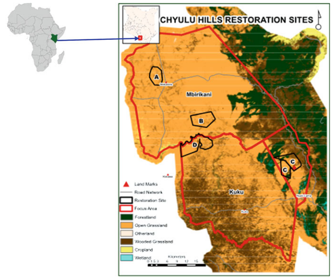
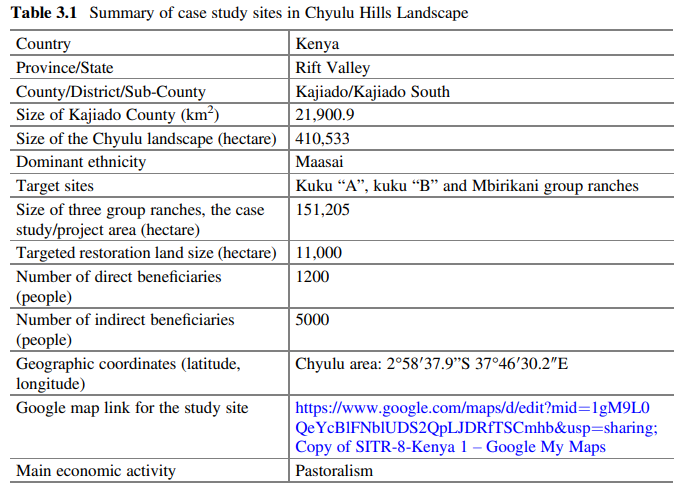
Kenya’s rangelands are classified as Arid and Semi-Arid Lands (ASALs), covering about 89% of the country’s land (Birch 2018, p. 2). Of Kenya’s 47 administrative counties, 23 are in ASALs (ACAPS 2022, p. 1), and 36% of Kenya’s population, 70% of its livestock herds, and 90% of its wildlife live in rangelands (Njoka et al. 2016, p. 11). The Chyulu landscape rangelands present an important socio-ecological production landscape (SEPL) because they provide distinct ecosystem services that sustain socio-economic development and maintain biodiversity for strengthened mutual human–nature interactions. The Chyulu landscape is a semiarid zone that provides dry-season grazing reserves for wildlife, and pastoral and agro-pastoral communities’ livestock. The livelihoods of over 2.5 million people in the largely pastoral communities of the Chyulu landscape are dependent on the rangelands (Opiyo et al. 2015, p. 298). The Chyulu landscape has gazetted protected areas: Chyulu, Amboseli and Tsavo National Parks, the Chyulu Forest Reserve, and local community group ranches, all of which are habitats for diverse wildlife species with potential for foreign exchange earnings. The Chyulu ecosystem is a habitat for African endemic “Big Five” animals—the elephant, African buffalo, lion, leopard, and black rhinoceros. Chyulu’s area is approximately 420,000 ha and serves as a vital water tower for over three counties in the region and beyond, including Kajiado, Taita Taveta, Kilifi, and the coastal city of Mombasa (Fig. 3.1, Table 3.1). The Chyulu watershed has been recognised as a “fountain of life” (Mwaura et al. 2016, p. 46). Chyulu grasslands are crucial for local communities, especially for the livelihoods of indigenous pastoralists, fodder provision for livestock, biodiversity conservation for diverse flora and fauna species, and soil carbon sequestration.
Though Chyulu Hills Landscape as a SEPL has significant potential to provide a variety of vital ecosystem goods and services, its socio-ecological and economic sustainability is increasingly threatened by land degradation influenced both by anthropogenic and natural factors. Likewise, Kariuki et al. (2018, p. 47) concluded that sub-Saharan Africa’s rangelands are experiencing pressures related to climate change and habitat destruction. Competing land uses, overgrazing, poor resource management, increasing demand for and overexploitation of natural resources, logging, and charcoal production are evident in the Chyulu Hills Landscape. Declining Maasai traditional natural resource governance structures and limited management skills exacerbate the land degradation trend. Human factors are compounded by climate change events, mainly prolonged droughts, floods, unpredictable rainfall and seasonality patterns, and encroachment of invasive woody species on grasslands. The expansion of agricultural land due to an increasing human population has resulted in decreasing vegetation cover and encroachment into ecosystems such as wetlands (Pellikka et al. 2018, p. 178). Degradation continues to reduce the Chyulu rangelands’ vegetation cover, in particular the grasslands’ ecological capacity to provide ecosystem services, support biodiversity, and sustain human socioeconomic development. Vegetation cover reduction affects livestock and wildlife pasture and increases surface run-off and soil erosion, resulting in a reduction in soil organic carbon.
The Ecosystem-based Adaptation (EbA) approach and multi-stakeholder engagement that recognises multicultural indigenous knowledge and the value of nature can inspire rangeland natural resources management (NRM) and stimulate restoration actions for sustainable conservation of ecosystems in the face of climate change.Restored and managed SEPLs can sustain the provision of ecosystem services, conserve biodiversity, improve livestock productivity, and enhance the resilience of pastoralist communities to climate change. This approach can significantly reverse the land degradation trend. However, McGranahan and Kirkman (2013, p. 177) argue that sustainable rangeland management requires ecologically feasible strategies.
This chapter presents an assessment of the underlying ecological and socioeconomic dynamics of Chyulu Hills Landscape to support the designing of restoration interventions to reverse rangeland degradation and manage ecosystems for provision of goods and services for sustainable development. The specific study objectives were as follows:
- To assess land vegetation cover changes and carbon emissions.
- To evaluate landscape degradation and land productivity.
- To conduct a socio-economic feasibility assessment and design a rangeland restoration project.
The assessment was done as part of the Rangeland Restoration in Chyulu (RRC) project that aims to demonstrate that improved livestock and landscape management stimulates SEPL restoration, enhances carbon capture, builds climate-resilient ecosystems, and supports community livelihoods. The project applied the EbA strategy for climate change adaptation and an integrated natural resource management approach to generate sustainable socio-economic and ecological values across the Maasai community. The Chyulu Hills Landscape restoration case study is critically significant for SEPL management to sustain local communities’ livelihoods and biodiversity conservation, which mainly depend on rangeland-grassland ecosystems.
2 Materials and Methods
2.1 Description of Study Area
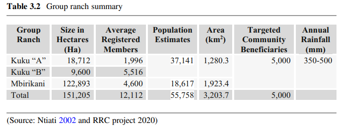
The Chyulu Hills Landscape in South-eastern Kenya covers the three counties of Kajiado, Makueni, and Taita Taveta (Figs. 3.1 and 3.2). The study was conducted in three Maasai community group ranches (Mbirikani, Kuku “A”, and Kuku “B”) within Kajiado County. Kajiado County covers an area of 21,900.9 km2 , and is situated between Longitudes 360 5′ and 370 5′ East and Latitudes 10 0′ and 30 0’ South (GoK 2018, p. 16). The Chyulu Hills Landscapes are a volcanic mountain range about 150 km east of the Kenya Rift Valley (Scoon 2015, p. 1) and represent a vital ecosystem in the semi-arid Chyulu landscape. The landscape covers Chyulu Hills National Park, Tsavo West National Park, five community group ranches, and the Kibwezi forest reserve. The lower parts of the hills are composed of grasslands and woodland thickets, while area 1800 metres above sea level (m.a.s.l) is dominated by montane forest. The landscape is predominantly a rangeland covered with grassland, important for livestock and wildlife pasture. The area has a bimodal rainfall pattern: October to December and between March and May. Annual precipitation ranges from 300 to 1250 mm. Temperature varies with altitude, ranging between 10 °C and 34 °C. The Chyulu Hills Landscape is characterised by climate change-induced long periods of drought and unreliable water sources. Pastoralism is the main economic activity. Main stocks are cattle, sheep, and goats. Pastoralism has been acknowledged in a recent study (Nyariki and Amwata 2019, p.1) as one of the main sources of livelihood in ASAL areas and contributors to Kenya’s economy. Other economic activities include agriculture, tourism, ranching, quarrying, and small- and medium-sized commercial enterprises. The Chyulu ecosystem is an important water catchment, source of community livelihoods, and key biodiversity area for flora and fauna.
The Chyulu area is dominated by indigenous Maasai pastoralists (about 90%), and Kamba and other immigrant communities (around 10%). The three group ranches studied are approximately 151,205 ha in size (Table 3.2) and located at different coordinates. About 8.5% of Mbirikani (37.59°E; 2.51o S) is open grassland (Maclennan et al. 2009, p. 2). Kuku “A” and Kuku “B” are semi-autonomous group ranches, both referred to as “Kuku”. The Kuku area is a crucial wildlife corridor between Amboseli and Tsavo National Parks. Kuku is located at 2°55′0“ S, 37° 40’60” E, at elevation of 1342 m.a.s.l. Previous studies (Kioko et al. 2006, p. 62) have reported the yellow fever tree (Acacia xanthophloea), Umbrella thorn (Acacia tortilis), and Blackthorn (Acacia mellifera) as the dominant tree species in the Chyulu Hills Landscape area.
2.2 Data Collection
Three prioritised group ranches were selected through purposive sampling based on multi-stakeholder participatory consultation and engagement through a stakeholder workshop, community agreements, the degradation status of the land where livelihoods are maintained, and restoration potential. Both qualitative and quantitative data on changes in vegetation cover, degradation, land productivity, and socioeconomic status were collected. Secondary data on landscape degradation were collected through a literature review, and primary data on the socio-economic context were through 18 focus group discussions (FGDs), field observation, 12 key informant interviews, and field transect walks. Geographic Information System (GIS) and remote sensing and field transect approaches were used to collect natural capital and landscape degradation spatial and temporal data. For data analysis related to objectives 1 and 2, the Trends Earth tool, based on 250 m resolution MODIS data, was applied to track time series changes in land vegetation cover and carbon emissions from deforestation during the 2000–2019 period. Land use and land cover maps were developed from Landsat satellite imagery. Normalised Difference Vegetation Index (NDVI) was utilised to assess land productivity. Descriptive statistics were applied to analyse data for objective 3 and presented in the form of graphs and tables.
3 Results of Ecological and Socio-Economic Dynamics Assessment
3.1 Geographic Information System and Remote Sensing Results
3.1.1 Land Vegetation Cover Changes
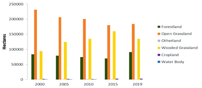
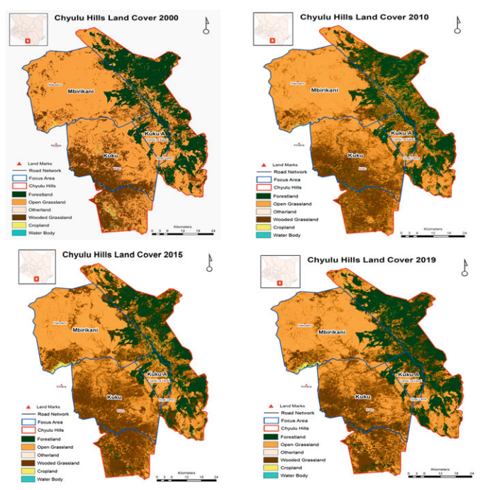
Figures 3.3 and 3.4 illustrate land vegetation cover changes in the sites between 2000 and 2019. Areas covered with trees increased by 13.42% (55,093 ha), while grassland declined by 1.1% (4515.86 ha). A decline in grassland is linked to increasing climate change-induced drought and overgrazing. Wetland and cropland areas were reduced by 0.66% (2709.5 ha) and 2.37% (9729.6 ha), respectively. Results corroborate the findings of Ehagi et al. (2018) that indicated reduction in land vegetation cover has extensive negative impacts on socio-economic development and ecological functions in Kajiado County.
Reduction in wetlands and croplands are closely correlated. Because agropastoralist farms are mainly rainfed, reduction in wetlands and long droughts influenced cropland expansion. For the purpose of this study, bushlands, open shrubland, and closed shrubland were clustered as tree-covered areas, and while they apparently show an increase, this does not imply that forested land increased. Decline in the grassland ecosystem has significant impacts on pastoral community livelihoods and biodiversity.
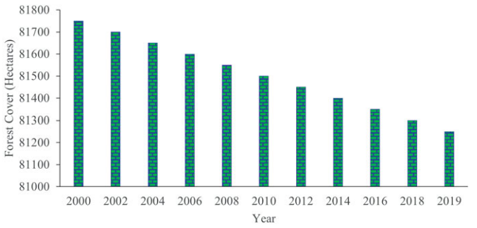
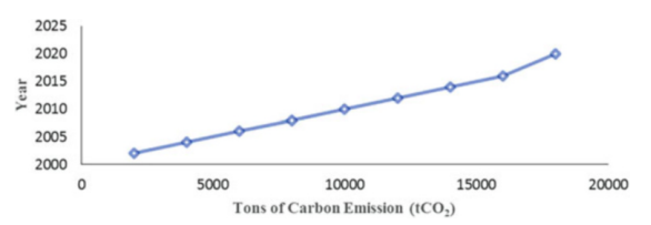
Trends in forest loss and carbon emissions between 2000 and 2019 are presented in Figs. 3.5 and 3.6, respectively. Results indicate declining (average 200 ha) forest cover in the three group ranches. This decline is linked to an increasing demand for forest products and agricultural land. A total of 70,472 metric tonnes of CO2 was emitted relative to forest cover reduction. Increased forest loss peaked in 2019 relative to high carbon emissions.
The results show that decreased forest cover increased the volume of carbon emissions. Oduor et al. (2018, p. 1) observed that changes in land vegetation cover influence greenhouse gas emissions from landscapes due to deforestation practices. However, livestock enteric fermentation emissions across the Chyulu landscape were estimated at 32,000 tCO2 /year. In the RRC project report, assessment of carbon sequestration potential from grassland restoration activities was projected to fall between 55,000 and 285,000 tCO2 over a period of 5 years, based on the Verified Carbon Standards (VM0032) methodology.
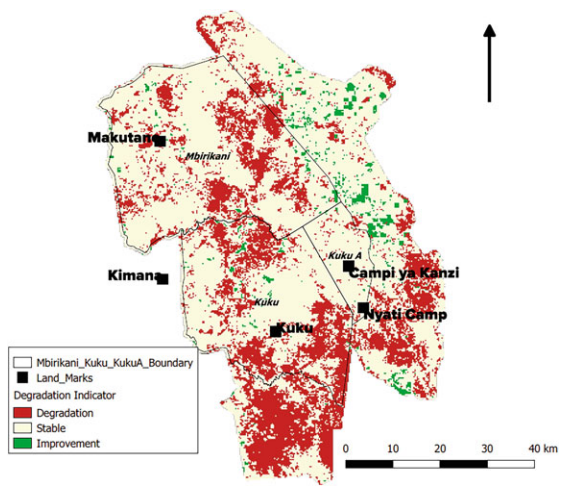
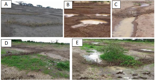
3.1.2 Landscape Degradation and Land Productivity (Fig. 3.7)
Approximately 27% (1,193.9 km2 ) of land in the study sites was degraded, i.e. was either eroded, had reduced or no vegetation cover, or the land was overgrazed. Kuku ranches were highly degraded compared to Mbirikani. The variation in degradation is related to weak or lack of land management plans and the high livestock stock rate in Kuku compared to Mbirikani. The increased number of livestock herds in Kuku from outside the ranch compounded with a weak group ranch grazing management committee compared to Mbirikani also explains the variation in degradation levels. Land degradation impedes the function of the rangeland to provide ecosystem services for people’s well-being and biodiversity conservation, as natural resources become scarce or no longer exist in degraded lands.
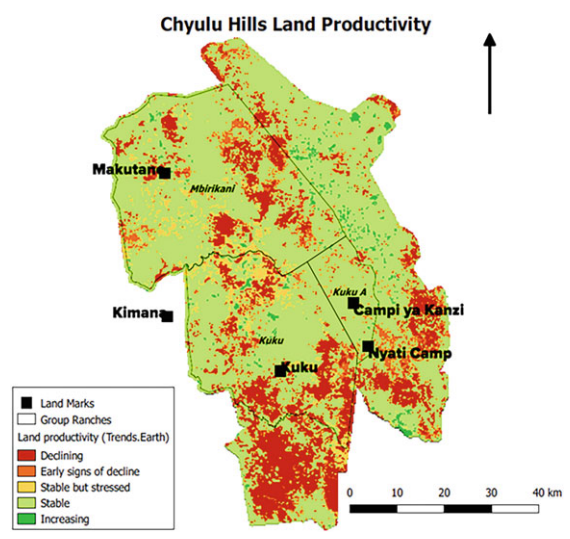
Normalised Difference Vegetation Index (NDVI) results revealed a declining land productivity trend (Fig. 3.8). Kuku group ranches had a higher level of decreased land productivity compared to Mbirikani. This variation is linked to the high degradation level in Kuku compared to Mbirikani. Degradation hinders the productivity of the grassland ecosystem and its capacity to provide pasture for wildlife, livestock, sequester carbon, and control soil erosion. A recent report on the effects of grassland degradation on soil quality and soil biotic community in a semi-arid temperate steppe (Han et al. 2020, p. 1) concluded that grassland degradation accelerates biodiversity loss and weakens ecological functions. The grassland ecosystem is the main source of livelihood for indigenous pastoral communities in the Chyulu landscape, and therefore, land degradation exacerbates the reduced climate resilience of community livelihoods and ecological functions.
3.2 Socio-Economic Status of the Group Ranches
Socio-economic results were important for informed decision-making in designing restoration activities in the target areas. Communities in the three sites had similar socio-economic and cultural dimensions. The ranches are owned by the indigenous Maasai community with similar leadership structures. Two main organisations working within the sites are the Maasai Wilderness Conservation Trust (MWCT) and Biglife Foundation (BLF) in Kuku and Mbirikani, respectively. The high degradation recorded was linked to increasing loss of vegetation cover and pastures for livestock and wildlife in three sites. Decreasing rainfall and unpredicted seasons were common challenges reported in the group ranches. The sites are further characterised by an increasing human population, and hence, livestock overstocking lead to overgrazing. Colonisation by an invasive species, Acacia oerfota, known to suppress grassland, was recorded at the sites, though a recent report has established that the species has medicinal and nutritional values (Zarei et al. 2015, p. 2311). Livestock-wildlife competition for pasture was more common in Mbirikani than in Kuku. Most of the springs, swamps, and other wetlands were degraded, resulting in reduced water sources for humans, livestock, and wildlife.
Socio-economic factors that affected sustainable management of the rangelands included low awareness and skills on sustainable rangelands management practices, increasing human population, unplanned increase of the settlement areas, declining indigenous knowledge and traditional systems of governance, low technical capacity of group ranches, and inadequate gender mainstreaming in rangelands management.
3.2.1 Traditional Governance Structure for Natural Resources Management
The analysis showed that the Maasai community traditionally had a system of rotational pasture grazing and biodiversity conservation governance structures. Community leadership encouraged and practised Oloopololi (grass seed bank and grazing rotation) system, conserved pasture reserve for livestock during drought, and owned land communally. However, with changing socio-economic trends, indigenous traditional knowledge and governance mechanisms have declined over time, contributing to landscape degradation. The study also found that rangeland degradation was linked to livestock mismanagement, decreasing traditional ecological knowledge, and poor group ranch governance.
3.2.2 Actions Proposed by Communities to Reverse Landscape Degradation Threats
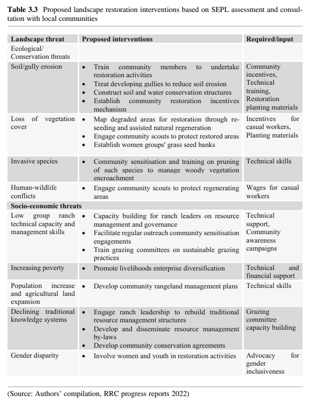
Through participatory FGDs, communities in the ranches proposed interventions to reverse ecosystem degradation, restore the landscape, and manage it sustainably (Table 3.3).
4 Designing of the Rangeland Restoration in Chyulu Hills Landscape
The assessment of the ecosystem, socio-economic, and ecological status of the landscape was used to guide the design for the RRC project for the targeted sites (Fig. 3.9).
The RRC project linked community development with restoration and improved rangeland natural resource management. Conservation International (CI) involved community group ranch leadership committees and two local NGOs in participatory designing of the project activities. The consultative approach also brought together other key stakeholders in the landscape, including local administration, community opinion leaders, and government extension agents.
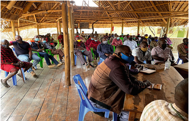
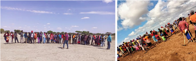
The joint participation enhanced landscape-wide involvement and commitment to sustainable restoration of degraded sites, while multi-stakeholder engagement built the long-term resilience of the rangeland SEPL. A stakeholder workshop in January 2020 provided a platform to share study assessment results on the level of degradation, natural capital, carbon accounting pathways, and socio-economic contexts of the sites. The workshop was used to design the restoration strategy and endorse selected intervention sites. Workshop proceedings later guided the August – September 2021 inception meeting with CI partners, including community project validation and initiation of the project implementation framework (Fig. 3.10).
4.1 Overall Approach of the RRC Project
Though the target sites have been exposed to land degradation, the stakeholders’ consultation, engagement, and landscape technical intervention strategic approaches have proven effective in reversing the degradation trend and restoring the degraded rangelands. The RRC project design was linked to an EbA approach. The Convention on Biological Diversity (2009, p. 9) defines EbA as an approach that involves the “use of biodiversity and ecosystem services as part of an overall strategy to help people adapt to the adverse effects of climate change”. The RRC EbA interventions included vegetation cover restoration, soil and water conservation, and conservation and sustainable management of grassland ecosystems based on integration of indigenous knowledge and traditional governance structures with scientific expertise. Rangeland restoration based on EbA and natural resource management practices is a cost-effective approach with the potential to stimulate natural regeneration and large-scale socio-ecological and economic impacts in ASAL areas (Bourne et al. 2017, p. 7).
4.2 Multi-Stakeholder-Driven Rangeland Restoration Strategy
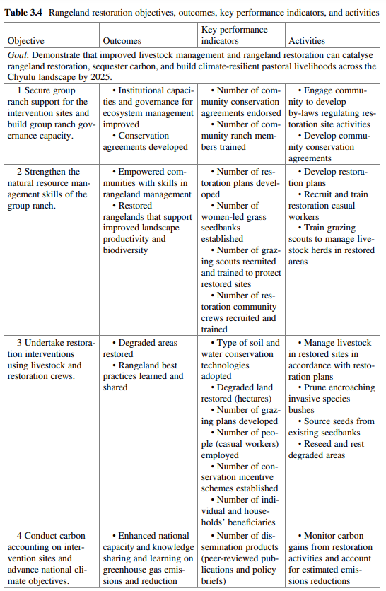
The participatory baseline study results guided the design of RRC project interventions. CI partnered with MWCT, BLF, and local community members to design and implement the RRC project activities. The community-driven strategic restoration design is structured along five objectives and expected outcomes, with key performance indicators to measure and assess progress (Table 3.4).
4.3 Progress and Achievements
4.3.1 Group Ranch Governance Capacity and Conservation Agreements
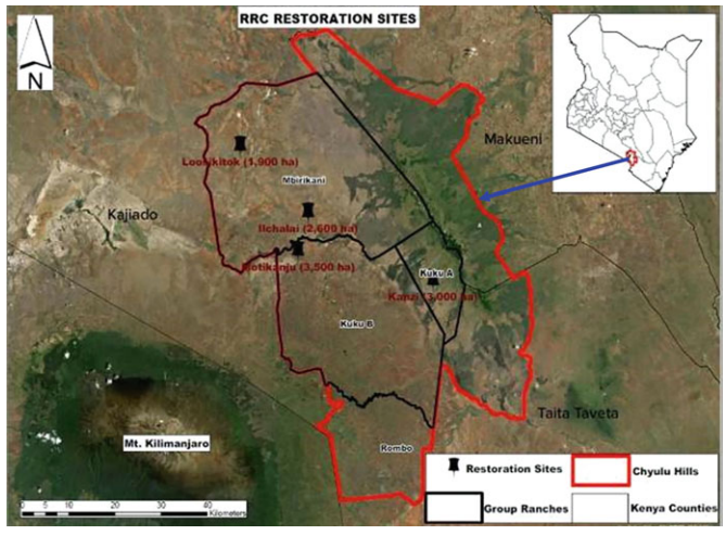
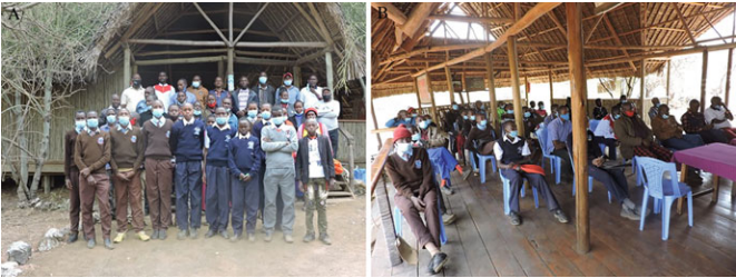
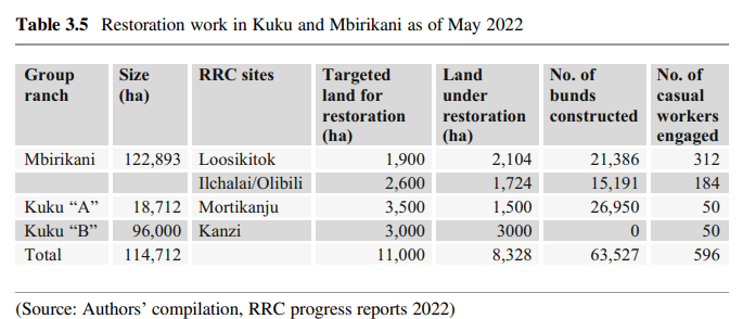
Ten community stakeholder engagements and capacity-building trainings on natural resource governance were conducted involving over 400 community members through community-based technical restoration managers and restoration officers who facilitated the day-to-day outreach activities. The technical team was trained on restoration techniques. Drafting of community conservation agreements with by-laws to conserve the four sites (Mbirikani: Loosikitok and Ilchalai; Kuku: Mortikanju and Kanzi) undergoing restoration has been initiated. The by-laws aim to contribute to rebuilding traditional resource management structures and practices such as Oloopololi. The agreements are voluntary and negotiated among community members who commit to specified restoration and conservation interventions motivated by restoration incentives (casual restoration jobs, capacity building, and restoration scholarships). The aim is to enhance community well-being and NRM in exchange for keeping livestock outside restored areas and only grazing them according to a planned schedule. A total of 596 locals have been offered casual employment and are earning direct income that is currently benefitting about 1,800 household members. Two group ranch restoration committees were established to support management of the restoration casual workers. Two community education committees were also formed to oversee the RRC restoration scholarships incentive package, and 17 students from 17 schools were selected to receive scholarships. Every year, 34 high school students will be identified to benefit from a partial restoration scholarship (Fig. 3.11).
4.3.2 Strengthened Natural Resource Management Skills
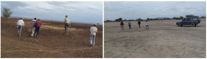
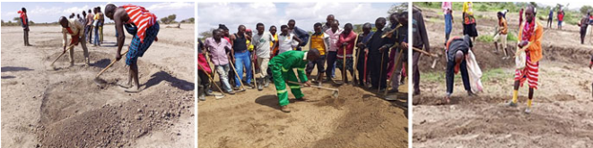
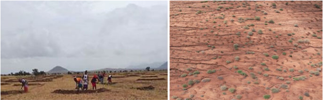
Regular outreach community meetings have been organised to build community capacity on resource management and promote ecological literacy and restoration extension services. Over 500 community group ranch members were trained during the first 9 months of 2021. Development of four restoration plans that leverage livestock management to restore target sites has been initiated through community participation. Four women’s groups (Inkisanjani, Lang’ata, Moilo, and Enkii) established grass seed bank restoration networks in Kuku to provide grass seeds for reseeding degraded sites and income generation for group members. Group ranches have identified 20 community scouts for training to support protection of restored areas. A total of 596 casual workers (Mbirikani: 312 for Loosikitok and 184 for Ilchalai; Kuku: 50 each for Mortikanju and Kanzi) were selected from households by group ranch committees and trained. The undertaking of restoration activities has hence created local employment and generated income for community households. The project targets 5000 beneficiaries through NRM capacity building, restoration jobs, and strengthening of local enterprises. Figures 3.12 and 3.13 illustrate stakeholder restoration work and current intervention impacts.
4.3.3 Restoration of Degraded Rangeland Using Livestock and Restoration Crews
Communities’ group ranch leaders were involved in the assessment process to identify appropriate site-specific restoration practices depending on level of site degradation. Trained casual workers implement restoration interventions, and expected socio-economic and ecological impacts are usually monitored before and after structural installations (Figs. 3.12, 3.13, 3.14, and 3.15).
Identified restoration interventions include construction of bunds or semi-circular micro-catchment Zai pits, stone lines, ponds, gully filling/healing, check dams, cut-off drains/ditches, sandbags, and contour grass strips. Constructed structures are complemented by grass reseeding and resting of degraded areas to stimulate assisted and natural vegetation regeneration correspondingly. A total of 8328 ha (as of June 2022) has been restored using different soil and water conservation structures, and rested and reseeded with grass species endemic to the sites, including Buffel grass (Cenchrus ciliaris), Masai love grass (Eragrostis superba), and Horsetail grass (Chloris roxburghiana). The project’s target is to restore 11,000 ha by March 2024. A planned grazing scheme will be deployed to sustainably manage restored sites and avoid reversal of gains. Each group ranch restoration committee has initiated the process to recruit 100 women casual workers to gather and provide seeds for species endemic to the sites in addition to seed banks (Table 3.5).
5 Conclusions and Recommendations
4.3.4 Carbon Accounting The RRC project adopted the Verified Carbon
Standards (VCS) methodology for sustainable grassland restoration through a grazing regulation plan. The approach is being used to estimate atmospheric carbon removals from grassland restoration and greenhouse gas (GHG) emissions reduction from grazing management. Monitoring indicators aligned with national accounting systems for accounting GHG emissions and reductions have been developed. Indicators include trends in soil organic carbon content, soil bulk density, seasonal and long-term changes in herbaceous biomass, and grazing intensity. The indicators are being monitored throughout the project implementation phase. Local communities and implementing partners have been trained to collect the soil samples and biomass data. Lessons learned from carbon accounting shall provide input to policy decisions related to carbon and inclusion of soil carbon in Kenya’s national policy decisions.
4.4 Future Challenges and Opportunities in the Restoration of the Chyulu Hills
Landscape The main challenges in the restoration of the Chyulu Hills Landscape rangeland ecosystem include limited and unpredictable precipitation, climate change, an increasing human population that exerts pressure on natural resources, lack of restoration plans and management capacity, group ranches land subdivision, limited funding for restoration, lack of or inadequate baseline information, and agriculture land expansion. However, increasing multi-stakeholder engagement in joint ecosystem restoration, community awareness on linkages between ecosystem degradation and their socio-economic well-being, and national and international commitments to mitigate climate change and restore ecosystems for livelihoods and biodiversity conservation present opportunities for future restoration efforts.
5 Discussion and Lessons Learnt
The Chyulu Hills Landscape provides abundant ecosystem services for people and conserves biodiversity. However, the ecosystem’s socio-economic and ecological potential is under the threat of degradation driven by climate and human factors. This study presented key socio-economic and ecological assessment findings showing that the Kuku “A”, Kuku “B”, and Mbirikani group ranches in the Chyulu SEPL are experiencing degradation that is negatively affecting livelihoods and biodiversity conservation. The baseline assessment was important to assess ecosystem status to guide the design of restoration interventions. Its results were also valuable in enabling communities to understand linkages between natural value and their social well-being, as well as to identify landscape-wide multi-stakeholder restoration actions to reverse ecosystem degradation and enhance the management of the landscape to sustain socio-economic and ecological benefits. The local communities’
traditional knowledge and natural resource governance structures, though declining because of changing social factors and economic diversification, still contribute immensely to the management of the landscape and were useful in designing the RRC project initiatives relative to the current social and conservation context.
The Maasai community’s willingness to integrate their traditional natural resource management structures into new technological approaches was important for project sustainability and replication to other rangelands. The RRC project has demonstrated the potential and needs for landscape-wide multi-stakeholder consultation in joint participatory action to restore ecosystems. Ecosystem degradation can be reversed through multi-stakeholder engagement that enables a better understanding of human–nature connectivity and facilitates collective actions.
Building community leadership skills in resource management have shown that management of rangelands can contribute to ecosystem restoration and biodiversity conservation. Training community members on soil and water conservation yields quick restoration results, mainly vegetation regeneration to stop further land degradation and provide pasture for livestock. Planned grazing and livestock management is one of the key strategies essential for grassland restoration. Grassland in Chyulu contributes to soil carbon sequestration and provides pasture and habitat for rangeland biodiversity protection. Community capacity building strengthens restoration and management skills for sustainable ecosystem conservation. The RRC activities in target sites aimed to demonstrate that improved livestock management can catalyse rangeland restoration, sequester carbon, and build climate-resilient pastoral communities’ livelihoods. The activities linked community development with improved natural resource management (NRM), restoration, and biodiversity protection.
The RRC project results have shown that restoration interventions can reverse the landscape degradation trend, improve grassland regeneration, rebuild indigenous ecological knowledge, improve group ranch natural resource governance, and enhance climate-resilient ecosystems and community livelihoods. Increased vegetation cover, control of soil erosion, community casual employment, and scholarships are some of the impactful incentives that motivate communities to restore and manage their SEPL. The timeframe of the RRC project is to end in March 2024. To date, interventions have established significant impacts on the restoration of this important SEPL, benefitting local people and improving ecological health for biodiversity benefits. Interesting observations from the RRC project include the increasing incidence of community members replicating learnt interventions on their own outside project sites, as well as multi-stakeholder collaboration on the commonly shared vision of restoring the landscape. Lessons from this case study can be replicated on a broader scale through rangeland restoration and improved land management by engaging landscape-wide multi-stakeholders.
Recognition of indigenous knowledge complemented the project’s incentives to rejuvenate the landscape and motivated the communities’ interest in restoring the degraded ecosystem. The local restoration casual jobs and support for youth education were critical social well-being incentives for the community to sustain conservation practices. Regular outreach and engagement contributed to rebuilding the communities’ ecological literacy and livestock management skills. Training community paraprofessionals in soil and water conservation, livelihood opportunities, and participation in monitoring and evaluation of project gains inspired community members to act and participate in SEPL restoration and management.
Communities in the landscape depend on rangeland for their livelihoods. However, land degradation negatively impacts ecological functions affecting human socio-economic development and biodiversity. The RRC restoration interventions to date have demonstrated how degradation can be successfully reversed to restore a SEPL for human-nature interactive connectivity. Community conservation agreements and long-term restoration plans are essential strategic pillars bringing together different stakeholders in the landscape for sustainable SEPL restoration and management. Multi-stakeholder collective action is an essential restoration approach that contributes to reversing landscape degradation, creating socio-economic opportunities for people, and conserving biodiversity.
6 Conclusion
The communities’ understanding of the indispensable value of the Chyulu landscape ecosystem to their livelihoods was the motivation behind multi-stakeholder efforts to restore and manage the degraded landscape for provision of ecosystem services, strengthening of climate resilience and local community well-being, and biodiversity conservation. This case study established the importance of a baseline assessment for informed decision-making in restoration project design. Decreasing land vegetation increased carbon emissions and accelerated ecosystem degradation. Landscape degradation reduces land productivity and affects sustainable provision of rangeland ecosystem services which support community well-being and biodiversity. By understanding the connectivity between nature’s value and their socio-economic dependence on productive ecosystems, community group ranches brought together different stakeholders to actively participate in ecosystem restoration activities in the landscape. The RRC project focused on restoring rangeland productivity and considered indigenous traditional knowledge and governance structures to be useful in guiding restoration project design for SEPL management. Traditional knowledge integration in project activities is important for communities to relate their knowledge on restoration activities of degraded ecosystems. It is recommended to replicate similar case study interventions for scale.
Acknowledgements The authors thank Apple and CI for financial facilitation. We thank the editorial team for their guidance and paper review and peer reviewers for their useful comments which improved our paper. We recognise the implementing partners (MWCT: George Kingola, David Okul, Timthy Lenaiya, and BLF: Ernest Lenkoina and Jeremy Goss) for their cooperation and delivery on planned expected outcomes. We acknowledge CI Vital Signs for leading data collection, botanists Christopher Chesire and Mwadime Nyange and the Field Assistants from Kuku and Mbirikani. We thank the leadership of the group ranches for giving us the approval to carry out data collection. We are highly indebted to the Maasai communities for their cooperation and participation during the feasibility study and ongoing project implementation.
References
ACAPS (2022) Kenya: impact of drought on the arid and semi-arid regions. Assessment Capacities Project (ACAPS) thematic report, Kenya, viewed 26 April 2022, Retrieved from https://www.acaps.org/sites/acaps/files/products/files/20220331_acaps_thematic_report_kenyaimpact_of_drought.pdf
Ahlström A, Raupach MR, Schurgers G, Smith B, Arneth A, Jung M, Reichstein M, Canadell JG, Friedlingstein P, Jain AK (2015) The dominant role of semi-arid ecosystems in the trend and variability of the land CO2 sink. Science 348:895–899
Baer SG, Birgé HE (2018) Soil ecosystem services: an overview. In: Reicosky D (ed) Managing soil health for sustainable agriculture, vol 1. Burleigh Dodds Science Publishing, pp 1–24
Bengtsson JJ, Bullock M, Egoh B, Everson C, Everson T, O’Connor T (2019) Grasslands-more important for ecosystem services than you might think. Ecosphere 10(2):1–20
Birch I (2018) Economic growth in the arid and semi-arid lands of Kenya. Knowledge, Evidence and Learning for Development Report, 2018, Kenya, viewed 26 April 2022. Retrieved from https://assets.publishing.service.gov.uk/media/5c6fd72aed915d4a315f6552/482_Economic_Growth_in_the_Arid_And_Semi-Arid_Lands_of_Kenya.pdf
Bourne A, Muller H, Villiers AD, Alam M, Hole D (2017) Assessing the efficiency and effectiveness of rangeland restoration in Namaqualand, South Africa. Plant Ecol 218:7–22. https://doi.org/10.1007/s11258-016-0644-3
Ehagi D, Omuterema S, Nyandiko N (2018) Contributions of the agro-pastoral livelihoods to land cover change in Kajiado west Sub-County. Int J Sci Res Publ 8(6):254–258
Gann GD, Lamb D (Eds.) (2006) Ecological restoration: A mean of conserving biodiversity and sustaining livelihoods. Society for Ecological Restoration International and International Union for Conservation of Nature and Natural Resources, version 1.1, viewed 22 November 2021. Retrieved from https://cdn.ymaws.com/www.ser.org/resource/resmgr/custompages/publica
tions/ser_publications/Global_Rationale_English.pdf
Godde CM, Boone RB, Ash AJ, Waha K, Sloat LL, Thornton PK, Herrero M (2020) Global rangeland production systems and livelihoods at threat under climate change and variability. Environ Res Lett 15(4):2
Government of Kenya (GoK) (2018) County Government of Kajiado, County Integrated Development Plan 2018-2022. Government Printer, Nairobi-Kenya, viewed 25 December, 2021. Retrieved from Kajiado County Integrated Development Plan 2018-2022.pdf (kippra.or.ke), https://repository.kippra.or.ke/bitstream/handle/123456789/995/Kajiado%20County%20Integrated%20Development%20Plan%202018-2022.pdf?sequence=1 & isAllowed=y
Gu H, Subramanian SM (2014) Drivers of change in socio-ecological production landscapes: implications for better management. Ecol Soc 19(1)
Han X, Li Y, Du X, Li Y, Wang Z, Jiang S, Li Q (2020) Effect of grassland degradation on soil quality and soil biotic community in a semi-arid temperate steppe. Ecol Process 9(63):1–11
Idaho Rangeland Commission (2012) Rangelands. An Introduction to Idaho’s Wild Open Spaces. Rangeland Centre, University of Idaho, viewed 13 May 2022. Retrieved from Introduction-toRangelands-Launchbaugh.pdf (evergreen.edu)
Kariuki R, Willcock S, Marchant R (2018) Rangeland livelihood strategies under varying climate regimes: model insights from southern Kenya. Land 7(2):47
Kioko J, Okello M, Muruthi P (2006) Elephant numbers and distribution in the Tsavo-Amboseli ecosystem, south-western Kenya. Pachyderm 40:61–68. viewed 27 December 2021. Retrieved from https://www.awf.org/sites/default/files/media/Resources/Books%2520and%2520Papers/Pachy40.pdf
Lee HJ, Sung K (2018) Analysis of domestic and foreign local biodiversity strategies and action plan (LBSAP) using semantic network analysis. J Environ Impact Assess 27(1):92–104. https://doi.org/10.14249/eia.2018.27.1.92
Maclennan SD, Groom RJ, Macdonald DW, Frank LG (2009) Evaluation of a compensation scheme to bring about pastoralist tolerance of lions. Biol Conserv 142(11):2419
McGranahan DA, Kirkman KP (2013) Multifunctional rangeland in southern Africa: managing for production, conservation, and resilience with fire and grazing. Land 2(2):176–193
Mwaura F, Kiringe JW, Warinwa F, Wandera P (2016) Estimation of the economic value for the consumptive water use ecosystem service benefits of the Chyulu Hills landscape watershed, Kenya. Int J Agric Forestry Fisheries 4(4):36–48
Ntiati P (2002) Group ranches subdivision study in Loitokitok division of Kajiado District, Kenya. In: The land use change, impacts and dynamics project (LUCIDP)’, working paper, no.7. Nairobi, Kenya. International Livestock Research Institute. viewed 26 December 2021. Retrieved from https://cgspace.cgiar.org/bitstream/handle/10568/1826/Lucid_wp7.pdf?
sequence=1
Njoka JT, Yanda P, Maganga F, Liwenga E, Kateka A, Henku A, Mabhuye E, Malik N, Bavo C (2016) Kenya: Country situation assessment (working paper), viewed 23 December, 2021. Retrieved from https://idl-bnc-idrc.dspacedirect.org/bitstream/handle/10625/58566/IDL58566.pdf?sequence=2&isAllowed=y
Nyariki DM, Amwata DA (2019) The value of pastoralism in Kenya: application of total economic value approach. Pastoralism Res Policy Pract 9(1):1–13
Oduor CO, Karanja N, Onwong’a R, Mureithi S, Pelster D, Nyberg G (2018) Pasture enclosures increase soil carbon dioxide flux rate in semiarid rangeland, Kenya. Carbon Balance Manag 13(24):1–13
Opiyo F, Wasonga O, Nyangito M, Schilling J, Munang R (2015) Drought adaptation and coping strategies among the Turkana pastoralists of northern Kenya. Int J Disaster Risk Sci 6:295–309
Pellikka PKE, Heikinheimo V, Hietanen J, Schäfer E, Siljander M, Heiskanen J (2018) Impact of land cover change on aboveground carbon stocks in Afromontane landscape in Kenya. Appl Geogr 94:178–189
Rangelands Atlas (2021) Rangelands Atlas Nairobi Kenya. ILRI, IUCN, FAO, WWF, UNEP and ILC, viewed 19 December 2021. Retrieved from https://www.rangelandsdata.org/atlas/sites/default/files/2021-05/Rangelands%20Atlas.pdf
Reicosky D (2018) Managing soil health for sustainable agriculture, Vol. 1 Fundamentals. Burleigh Dodds Science Publishing
Rist L, Uma Shaanker R, Milner-Gulland EJ, Ghazoul J (2010) The use of traditional ecological knowledge in forest management: an example from India. Ecol Soc 15(1):1–20
Sala OE, Yahdjian L, Havstad K, Aguiar MR (2017) Rangeland ecosystem services: Nature’s supply and humans demand. In: Briske D (ed) Rangeland Systems. Springer Series on Environmental Management, pp 467–489. https://doi.org/10.1007/978-3-319-46709-2_14
Scoon R (2015) Geotraveller 21: Tsavo, Chyulu Hills and Amboseli, Kenya: Ancient landscapes and young volcanism (Geobulletin March 2015, Quarterly Publication of the GSSA), Academia. edu viewed 14 February 2022. Retrieved from https://www.academia.edu/en/62051043/Geotraveller_21_Tsavo_Chyulu_Hills_and_Amboseli_Kenya_Ancient_landscapes_and_young_volcanism_Geobulletin_March_2015_Quarterly_Publication_of_the_GSSA
Selemani IS (2020) Indigenous knowledge and rangelands’ biodiversity conservation in Tanzania: success and failure. Biodivers Conserv 29(14):3863–3876. https://doi.org/10.1007/s10531-020-02060-z
Zarei M, Asgarpanah J, Ziarati P (2015) Chemical composition profile of wild acacia Oerfota (Forssk) Schweinf seed growing in the south of Iran. Orient J Chem 31(4):2311–2318
Note
The opinions expressed in this chapter are those of the author(s) and do not necessarily reflect the views of UNU-IAS, its Board of Directors, or the countries they represent.
Open Access This chapter is licenced under the terms of the Creative Commons AttributionNonCommercial-ShareAlike 3.0 IGO licence (http://creativecommons.org/licenses/by-nc-sa/3.0/ igo/), which permits any noncommercial use, sharing, adaptation, distribution and reproduction in any medium or format, as long as you give appropriate credit to UNU-IAS, provide a link to the Creative Commons licence and indicate if changes were made. If you remix, transform, or build upon this book or a part thereof, you must distribute your contributions under the same licence as the original. The use of the UNU-IAS name and logo, shall be subject to a separate written licence agreement between UNU-IAS and the user and is not authorised as part of this CC BY-NC-SA 3.0 IGO licence. Note that the link provided above includes additional terms and conditions of the licence.
The images or other third party material in this chapter are included in the chapter’s Creative Commons licence, unless indicated otherwise in a credit line to the material. If material is not included in the chapter’s Creative Commons licence and your intended use is not permitted by statutory regulation or exceeds the permitted use, you will need to obtain permission directly from
the copyright holder.