COMDEKS Project: Makawanpur District, Nepal
06.03.2017
-
SUBMITTED ORGANISATION :
-
United Nations Development Programme (UNDP); Ministry of the Environment, Japan; Secretariat of the Convention on Biological Diversity; United Nations University (UNU)
-
DATE OF SUBMISSION :
-
06/03/2017
-
REGION :
-
Southern Asia
-
COUNTRY :
-
Nepal (Makawanpur District)
-
SUMMARY :
-
The Community Development and Knowledge Management for the Satoyama Initiative Programme (COMDEKS) was launched in 2011 to support local community activities that maintain and rebuild target production landscapes and seascapes, and to collect and disseminate knowledge and experiences from successful on-the-ground actions so that, if feasible, they can be adapted by other communities throughout the world to their specific conditions. The programme provides small-scale finance to local community organizations in developing countries to support sound biodiversity and ecosystem management as well as to develop or strengthen sustainable livelihood activities planned and executed by community members themselves. The COMDEKS target landscape in Nepal is located in the Makawanpur District in the country’s central region, and covers an area of 78,900 ha.
-
KEYWORD :
-
Mountains, Resilience, Forestry, Agriculture, Alternative livelihoods
-
AUTHOR:
-
United Nations Development Programme (UNDP)
-
LINK:
-
http://collections.unu.edu/eserv/UNU:6012/communities_in_action_comdeks.pdf#page=114
Summary Sheet
The summary sheet for this case study is available here.
The Landscape
Geography
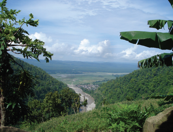
The COMDEKS target landscape in Nepal is located in the Makawanpur District in the country’s central region, and covers an area of 78,900 ha. The Makawanpur region is comprised of a diverse mosaic of ecosystems, and lies in the Manahari River watershed, which drains into the Rapti River. The landscape is composed of hills and flat plains, with nearly half of the area under forest. Hill slopes range from less than 10° to more than 30°. Climate varies by altitude, with a near-temperate climate at higher altitudes, and a near-tropical climate at lower elevations. An analysis of climate trends between 1996 and 2010 shows that annual rainfall is decreasing, and the minimum temperature is increasing.
The hilly terrain and mosaic of alluvial plains has been formed by the actions of water flow and gravity. Rural communities within the East Rapti River Basin have a close relationship with the flow of the river and its tributaries. Communities are dependent on the river for fishing, timber collection during floods, subsistence farming, washing, bathing, swimming and other activities. However, the sandy texture of the soil has implications for water management. The coarse soil is unable to hold water, resulting in increased surface runoff. Soil erosion and landslides are common upstream, while intense flooding occurs downstream. An investigation following a massive flood in 1993 showed that nearly 40 percent of the watershed is designated as a “very high” and “high” hazard zone for landslides; 7 percent is susceptible to debris flow hazards; and 4 percent is a “high” hazard flood zone. Thus, the landscape is known as one of the most hazard-prone areas in central Nepal.
The target area covers 10 designated administrative units known as Village Development Committees (VDCs): Handikhola, Bharta, Raksirang, Kankada, Dandakharka, Khairang, Kalikatar, Namtar, Manahari and Sarikhet. Some areas of the Manahari hills lie in the buffer zone of Chitwan National Park, whereas part of Manahari and Handikhola fall in the buffer zone of Parsa Wildlife Reserve.
Biological Resources and Land Use
Forested areas in the lower hills of the landscape are composed of Sal (Shorea robusta) and other hardwood species. The upper region of the Mahabharat hills has different hardwood species such as Painyu (Prunus cerasoides) and Katus (Castanopsis indica). The forests along the banks of the Rapti and Manhari Rivers are distinct with patches of Sisso (Dalbergia sisso), Khair (Acacia catechu) and Simal (Bombax ceiba). Only 8 percent of the area is cultivated, due to the risks associated with the unstable, sloped terrain. Agricultural areas are dominated by maize cropping systems. Pulses such as peas and soybeans are grown as intercrops. Existing GEF Small Grants Programme projects in the area are now promoting agroforestry systems, where banana, amriso, pineapple and fodder trees are planted. Cultivation of vegetables such as cauliflower, cabbage, potatoes, and beans is also becoming more common.
Socioeconomic Context
The Makawanpur region is home to indigenous groups such as the Chepang, Tamang, Bote and Danuwar. The 2001 census counted some 13,400 households with nearly 78,000 people. The Tamangs comprise 52 percent of the population, and the Chepangs 17 percent. Both groups are regarded as among the most marginalized and resource-poor groups in Nepal. Small land holdings (less than one hectare) provide no more than three to six months of food security. Additional challenges include low education levels, insufficient access to basic social services, and high population density on a fragile landscape.
Recurring disasters such as famines and floods further induce poverty for the inhabitants of the area. Although all inhabitants experience these challenges, several “hotspot” areas have been identified where the livelihoods of local populations are especially threatened. These areas are highly poverty-ridden, with inequitable land tenure arrangements and limited access to other natural resources. The access of indigenous groups to land and resources has diminished drastically over time due to exclusionary policies associated with land and forest use and nature conservation, contributing to poor food security and unsustainable land degradation.
Key Environmental and Social Challenges
Key environmental challenges are natural hazards and local land use practices. The hilly and mountainous terrain presents a challenge for natural resources management. Landslides and erosion become more likely as the slope increases. Accessible water also becomes increasingly scarce as altitude increases, and the costs associated with development and transporting goods increase as well. Erosion leads to loss of topsoil, and a significant decline in land productivity. The soil is transported as alluvial deposits in the river valleys, which causes a rise in the riverbeds. The resulting change in topography threatens the existence of nearby settlements.
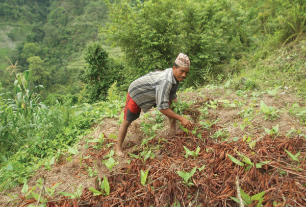
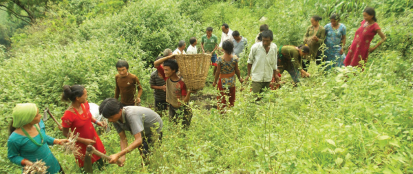
Farmers in Nepal using Sloping Agriculture Land Technology (SALT), COMDEKS Nepal
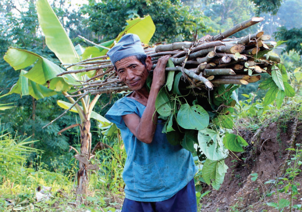
Although the topography and geology of the target landscape is naturally prone to landslide and flooding, land use practices in the region are also equally to blame for the area’s high incidence of natural hazards. In fact, slash-and-burn agriculture practiced by the indigenous Chepang and Tamang people is a key challenge to the landscape. It is the dominant land use practice in parts of more than 20 hill districts of Nepal, particularly in inaccessible and steep lands. Slash-and-burn agriculture may be sustainable if adequate fallow periods are incorporated into the farming cycle. However, the reduction of the traditional 3-5 year cultivation cycle to a virtually annual cycle has led to serious erosion problems. Indigenous Chepang and Tamang groups that rely on slash-and-burn agriculture have significantly decreased the productivity of the upland areas where they dwell through deforestation, loss of biodiversity, forest fires, and serious soil erosion. Other practices, such as planting maize in steep outward-sloping terraces, have also led to significant loss of topsoil, thus increasing surface run off.
Extraction of sand, gravel, and stones from the landscape for profit presents another environmental challenge. The expansion of extractive industries along the banks of the Rapti and Manahari Rivers may affect the local ecosystem should these resources become over-exploited.
COMDEKS Activities, Achievements, and Impacts
Community Consultation and Baseline Assessment
The baseline assessment was conducted by the Manahari Development Institute (MDI), a national NGO. Stakeholders convened for a rigorous pre-workshop in Daman, Nepal on June 20, 2012 to establish the boundaries of the target landscape. The 32 stakeholders that participated included representatives from the District Development Committee, heads of district line agencies, local political leaders, journalists, and farmers from the landscape. A study team of experts including agro-forestry and GIS professionals, engineers and rural officers was formed with the mandate to carry out the field surveys and workshop exercises.
After the pre-workshop, baseline surveys were carried out in all 10 selected Village Development Committees. Over 200 households were surveyed across the landscape, taking care to include women, Janajati, Dalit, and other marginalized households. Questions about the landscape were divided into four categories: ecosystem protection; agricultural biodiversity; local knowledge, learning and innovation; and social equity and infrastructure. Survey answers were used to help measure and understand the resilience of the target landscape. All questions were translated into Nepali, and for each question, ground-level examples were presented by facilitators, study team members and locals.
The survey scorecard results were consolidated into visual diagrams displaying the baseline performance in each VDC. Additional radar diagrams were completed to consider gender-based differences in survey answers. The results of the resilience indicators, as well as field analysis, revealed that the main concerns for community members were the recurrent floods and landslides affecting the target landscape, the effects of slash-and-burn agriculture and the resulting deforestation, the loss of agricultural biodiversity, and the sharp decline in agriculture productivity of cereals and vegetables.

Integrated farming of carp and small indigenous species (Carp-SIS polyculture) is practiced in the target area, COMDEKS Nepal
Landscape Strategy
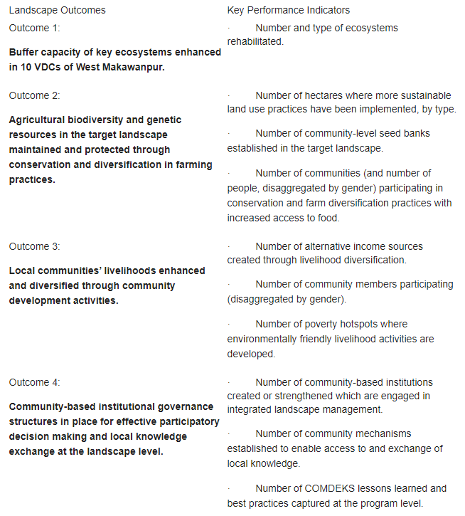
The information gathered from the baseline assessment was used to develop the COMDEKS Country Programme Landscape Strategy for Nepal. The strategy describes a community approach to maintaining, restoring and revitalizing sustainable socio-ecological production in the landscape, with activities proceeding at both the community and landscape levels. Table N-1 shows the four Landscape Outcomes around which the strategy is built, as well as the performance indicators that will be used to measure these outcomes.
Table N-1. Landscape Outcomes and Indicators from the Nepal Landscape Strategy
To achieve these outcomes, communities will be guided by the following principles in their choice of local projects:
Increasing connectivity: Connectivity is defined as integrating the fragmented patches of different ecosystems (cultivated land, forest, water, etc.) for conservation and production to improve the livelihood of the local communities on a sustained basis as well as to improve the habitat of wild animals by connecting forest patches through tree-planting and conservation activities. More broadly, it also connotes the integration of different ecosystems to generate synergies across ecosystems towards better productivity, as opposed to fragmented system operation. It also includes promoting integrated water resource management for more efficient use, to ensure local water supplies, and to mitigate potential disasters and land degradation.
Addressing marginality and inequality: Poverty is rampant within the target landscape, and is a direct threat to the environment. Equality in opportunity is equally important. Therefore, these two aspects must be dealt with as soon as possible.
Diversification of land uses: Agricultural diversification has a direct influence on landscape resilience. During the baseline study, the majority of respondents reported that their resilience was enhanced after adding amriso, banana, pineapple, and citrus to their traditional cropping portfolio, so that even if one crop failed somehow, they could rely on others.
Respecting traditional knowledge and complementing it with innovations: Traditional knowledge is an outcome of several generations’ informal research, and hence should not be ignored. This knowledge might be mixed with new innovations to produce even better livelihood outcomes. Thus, a system of documenting and disseminating traditional knowledge should be put in place. During the baseline assessment, it was found that there was certain local knowledge transmitted (through oral traditions) and used, but this was not systematically documented. For tracking innovations, continuous research will be needed.
Synergy building: Discussions during the baseline assessment survey revealed that there are noted synergies between certain livelihood activities. For example, honey-bee keeping and mustard/chiuri cultivation side by side improves the yield of mustard/chiuri through better pollination and at the same time improves the honey yield due to the higher availability of pollen sources. Similarly, higher bat population near pulse fields enhances the pulse yield because the bats eat the harmful insects affecting pulse crops. More of such synergistic enterprises springing from indigenous knowledge must be explored and used. On a landscape level, the potential synergy between hills and plains could be in the form of producing off-season vegetables when these are not feasible in the plains and producing the same vegetables in the plains at a much lower cost in the regular season.
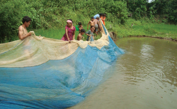
Harvesting carps and small indigenous species, COMDEKS Nepal
Gender and Social Inclusion: Local projects will favor women’s participation because women play a major role in producing, harvesting, and marketing of several crops and livestock. Women will be the special targets of promotional and awareness-raising campaigns. Special efforts will also be made to identify and link women’s group to credit sources in order to overcome the financial constraints that many female-headed households are confronted with.
Market linkage: For the improvement of livelihoods, links to markets for the products generated through local projects is essential. Pursuing market linkages will also include institutional development, such as the formation of cooperatives, which also provides backward linkages to enhance production.
Community-Led Landscape Projects
The COMDEKS Nepal Country Programme has a portfolio of six local projects, supported by small grants ranging from US$24,000 to US$41,500 to six NGOs (see Table N-2):
Table N-2. COMDEKS Community-Led Projects in Makawanpur District, Nepal
| Project | Grantee (NGO) | Contribution to Landscape Resilience Outcomes | Description |
| Building Resilience of Livelihoods at the Landscape Level by Strengthening the Capacity of Local Institutions and Fostering Knowledge Management | National Disaster Risk Reduction Centre Nepal (NDRC Nepal)
US$34,100 |
Outcomes 1, 2, 3, 4 | Promote agroforestry to replace slash-and-burn farming; introduce SALT techniques for farming slopes; encourage micro-irrigation systems. Increase livelihood security by introducing new vegetable and other alternative cash crops. Establish and strengthen farmer cooperatives. Create mechanism for exchange of local knowledge. Target VDCs: Sariket, Namtar, and Kalikatar. |
| Community-Based Ecosystem Protection and Sustainable Livelihood Support | Community Resource Management Centre (CRMC)
US$42,400 |
Outcomes 2, 3, 4 | Improve the sustainability and profitability of local farming by introducing farming techniques suitable for steep slopes; encouraging agroforestry and enrichment planting; constructing micro-irrigation facilities; providing improved seed varieties; and promoting formation of saving and credit groups. Improve energy options through improved cook stoves, biogas, and training in making bio-briquettes. Targeted VDCs: Kalikatar and Dandakharka. |
| Conserving Hill Slopes with Improved Agroforestry Systems | Women, Children and Environment Development Centre
US$24,000 |
Outcomes 1, 2, 4 | Bring marginal lands under sustainable management by encouraging SALT techniques and through planting fruits and other NTFPs such as broomgrass and bamboo. Improve domestic and irrigation water supplies by establishing water harvesting ponds and up-grading local water systems. Establish village savings and conservation groups to undertake local green development projects for income generation. Conduct training courses in agroforestry and local water management. Targeted VDCs: Kalikatar and Namtar. |
| Conservation and Maintenance of Biological Diversity Important to Agriculture in West Makawanpur | Development Organization for Community—Nepal.
US$49,300 |
Outcomes 1, 2, 4 | Establish community seed banks to promote crop varieties tolerant of pests, diseases, and other threats. Rehabilitate slash-and-burn areas with agroforestry techniques such as alley cropping. Promote water-conserving irrigation systems, as well as carp polyculture. Encourage formation of local conservation groups and their federation into landscape level organizations.
Targeted VDCs: Khairang, Dandakharka, Bharta, Kalikatar, and Namtar. |
| Empowering Farming Families as Successful Commercial Organic Vegetable Producers at Handikhola VDC of Makawanpur District | Institute for Sustainable Agriculture Nepal
US$41,500 |
Outcomes 2, 3, 4 | Establish farmers in Handikhola VDC as commercial vegetable producers by: facilitating the creation of a vegetable farmers cooperative and organizing production groups of 20-25 farmers; training farmers in organic farming methods and marketing practices; making appropriate seeds available; establishing a collection center to aid vegetable distribution and marketing.
Targeted VDC: Handikhola |
| Improving Livelihoods of Marginalized People Through Socio-ecological Production Landscape in Makawanpur District | Multi-dimensional Resource Centre Nepal
US$39,300 |
Outcomes 2, 3 | Reorient local agriculture to make it less destructive and more productive and profitable by: creating local farmer groups, training local farmers in eco-agriculture methods; establishing a local plant nursery and seed bank to provide high-quality planting materials; transitioning away from slash-and-burn through planting fruit trees, fodder, and broomgrass; promoting commercial vegetable production through riverbank cultivation; and identifying and documenting traditional farming knowledge that is biodiversity friendly.
Targeted VDCs: Rakshirang and Manahari. |
Banana, pineapples and broomgrass are grown using SALT technology and sold in Manahari, a local market, COMDEKS Nepal
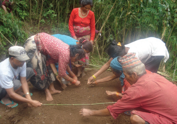
Preparing a seed bed for vegetables, COMDEKS Nepal
Achievements and Impacts to Date
- Converting slash-and-burn agriculture to agroforestry: Nearly 450 ha of sloping land that had been used in slash and burn agriculture have been brought under agroforestry. Over 1 million seedlings have been used in this effort, including over 900,000 broomgrass plants to stabilize slopes and prevent erosion, as well as some 140,000 banana trees and 30,000 lemon trees to increase household food security and income. This is part of the larger landscape-wide effort to move away from slash-and-burn agriculture and train local communities in the use of Sloping Agriculture Land Technology (SALT) techniques that use slope-adapted cropping practices to prevent soil loss and mitigate landslide risks.
|
“The lifestyle of Rabang village is changing. Earlier we used to go to market to buy food. But now we carry banana, broom grass or local chicken to sell in the market. With the money, we buy rice, cloth, slippers, books and stationery for children.”
–Mrs. Putali Maya Praja, COMDEKS grantee |
- Promoting new agricultural models and products to improve incomes and food security: Several innovations in local agriculture have begun to provide enhanced income and new food sources for local consumption. For example, river bed farming of ground nuts, watermelons and pointed gourds has allowed farmers to conserve river bank soils and to take advantage of areas that had been considered unusable. Promotion of organic agriculture, including new crops such as turmeric and ginger, has also brought new economic opportunities. For example, extension of irrigation to 7 ha of land and its conversion to vegetable farming allowed local farmers to produce 90 tons of vegetables with a market value of US$25,000. Another innovation involves remote village sites whose inaccessibility makes it unfeasible to raise fresh vegetables for the commercial market. Instead, these remote sites are being used to raise seeds, which, because they are dried, do not need to be rushed to market. One additional benefit of these new agricultural models is that they have provided an alternative to the growing of hemp in the area, which is illegal.
- Substituting fish farming for destructive fishing practices: As an alternative to river fishing, over 100 fish ponds have been constructed to raise a combination of carp and small indigenous fish species (SIS). Local fishing practices included a number of destructive techniques such as the use of poison and electrocution to stun fish, which had harmed local fish biodiversity. By comparison, the carp-SIS polyculture, in which river water is routed through the fish ponds, is both more productive and sustainable. The carp is sold for cash, while the farmers harvest the small indigenous fish for their own use, enhancing their incomes and food security simultaneously. Just as importantly, the projects are changing attitudes and policies around river fishing, particularly in the area around the Masine River, where a ban on river fishing has been adopted by the local community.
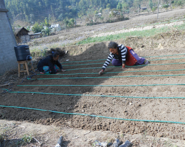
- Improving water availability for domestic and agricultural use. Considerable work has been done to improve water infrastructure in the area, including installation of 25 micro-irrigation structures, multi-use water systems that provide both domestic and crop water, drip irrigation systems, and micro-canal irrigation systems. In many instances, providing more secure water sources for farm and home use was one piece of an integrated strategy to replace slash-and-burn farming practices with more productive and sustainable practices. For example, in one remote village in Kalikatar VDC, a community project rehabilitated the local water system, including renovating a 4.5-km canal and the village road. The up-graded water system served 80 households and provided irrigation water for 14.5 ha of land in the valley, which was then suitable for new crops such as ginger, taro, and turmeric. This allowed villagers to convert nearby steep slopes from slash-and-burn agriculture (maize in this case) to agroforestry crops such as banana, pineapple, and other fruit trees, as well as leguminous trees.
- Connecting local community groups and projects with government support: In addition to helping local communities to create and train Community Based Organizations to carry out local project activities, a crucial institutional aspect of the COMDEKS Nepal work has been creating linkages between these groups and government departments that can offer technical support. For example, the Village Development Committees and the District Development Committee have supported efforts to promote agroforestry, extend irrigation systems, and develop vegetable farming. The District Forest Office and District Agriculture Office have also lent their support in forest conservation and agriculture promotion initiatives, respectively. For example, the District Forest Office has provided tree seedlings, while the District Agriculture Office has supplied fruit tree saplings, irrigation equipment, and support for fish pond construction and the purchase of fingerlings to stock the ponds, as well as providing technical support for vegetable farming. Developing these linkages is important as a way to increase the level of government services and create vital partnerships in this generally underserved region.
Progress at the Landscape Level
Nepal’s local project portfolio has been carefully developed so as to address the various ecosystem types throughout the landscape from riverine to mountain, and forest to grassland. It has placed a strong emphasis on reforming agricultural practices such as slash-and-burn farming that intensify local poverty through their lack of productivity, impair local ecosystems, and exacerbate landslide risks. Considerable progress has been made throughout the target landscape on adopting agroforestry, organic agriculture, and SALT practices more suitable for the landslide-prone terrain that can simultaneously increase incomes and add to the food security of local households. In order to improve partnership among the grantees, a bimonthly meeting of all grantees is convened. In addition, biannual learning and review workshops are held to encourage knowledge sharing among grantees. At the district level, an annual review is scheduled, with district level line agencies and the Member of Parliament representing the target landscape invited. One significant barrier to planning and action at the landscape level is the ruggedness of the terrain and the lack of road infrastructure, which makes travel and connection throughout the landscape difficult. This is particularly true during the monsoon season, when heavy rains swell streams, cause landslides, and interfere with crop agriculture. One way the Nepal COMDEKS program has tried to overcome this seasonal obstacle is by emphasizing agroforestry interventions that can be undertaken before the monsoon rains.
Drip irrigation, COMDEKS Nepal
Drip irrigation, COMDEKS Nepal
Lessons Learned
- There will be a continuing need for basic literacy and public awareness campaigns within the landscape communities to acquaint them with the benefits of changing their familiar agricultural patterns and adopting more sustainable—and profitable—practices. The message that there is a real connection between sounder farming practices, increased yields, new economic opportunities, and higher incomes will take time to be fully embraced by these very poor communities.
- While COMDEKS projects have been very successful in opening new opportunities and increasing local capacities for successful new ventures, these efforts will require additional support from government and other donors if they are to be replicated and up-scaled. For example, local knowledge about and expertise in agroforestry has increased greatly, but additional funding support will be needed to supply seedlings. Likewise, experience with carp-SIS polyculture has been positive, but support to purchase fingerlings to new ponds is still needed if this is to become a viable alternative livelihood locally.
- External policy support is required to tackle some of the environmental problems plaguing the target landscape. Not everything can be accomplished at the local level. For example, quarrying for boulders is rampant in the Chure region, a practice that disrupts and destabilizes the riverine ecosystem. Community effort alone has failed to control this practice. Although action to stop stone mining in Chure was pledged at the national level, this has not yet been translated into action. Without such action, this environmentally destructive practice will continue to act as a drag on local efforts to improve environmental conditions within the landscape.