COMDEKS Project: Himalayan State of Uttarakhand, India
06.03.2017
-
SUBMITTED ORGANISATION :
-
United Nations Development Programme (UNDP); Ministry of the Environment, Japan; Secretariat of the Convention on Biological Diversity; United Nations University (UNU)
-
DATE OF SUBMISSION :
-
06/03/2017
-
REGION :
-
Southern Asia
-
COUNTRY :
-
India (Uttarakhand State)
-
SUMMARY :
-
The Community Development and Knowledge Management for the Satoyama Initiative Programme (COMDEKS) was launched in 2011 to support local community activities that maintain and rebuild target production landscapes and seascapes, and to collect and disseminate knowledge and experiences from successful on-the-ground actions so that, if feasible, they can be adapted by other communities throughout the world to their specific conditions. The programme provides small-scale finance to local community organizations in developing countries to support sound biodiversity and ecosystem management as well as to develop or strengthen sustainable livelihood activities planned and executed by community members themselves. The COMDEKS target landscape in India includes an area of approximately 50,000 ha spread over six locations in Uttarakhand in the country’s north-central region.
-
KEYWORD :
-
Mountains, Agriculture, Erosion, Alternate livelihoods, Protected areas
-
AUTHOR:
-
United Nations Development Programme (UNDP)
-
LINK:
-
http://collections.unu.edu/eserv/UNU:6012/communities_in_action_comdeks.pdf#page=92
Summary Sheet
The summary sheet for this case study is available here.
The Landscape
Geography
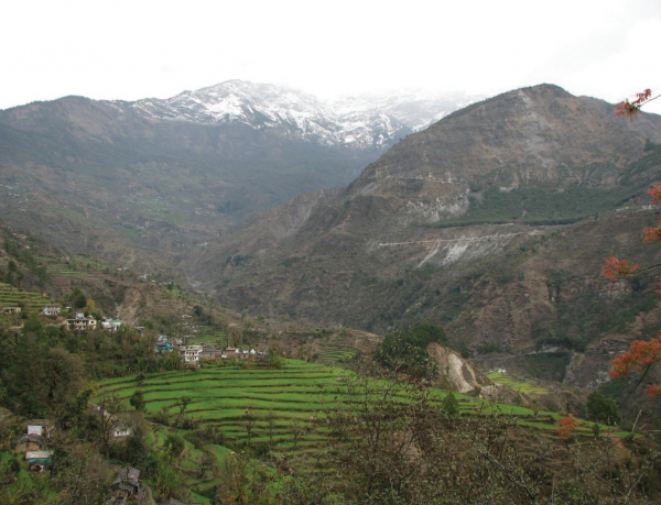
The COMDEKS target landscape in India includes an area of approximately 50,000 ha spread over six locations in Uttarakhand in the country’s north-central region. Of these six landscapes, Rasulpur is located in the foothills of the Himalayas, while Ranman, Almora and Kausani, Pipalkoti, Tadikhet, and Ranikhet lie within the Himalayan mountain region. Rasulpur lies near Rajaji National Park, near Haridwar, and hosts a large number of forest dwellers who were driven from the park without compensation and have turned to environmentally harmful practices.
The Uttarakhand State comprises 13 districts distributed over two administrative divisions, Garhwal and Kumaon, and shares international borders with Tibet in the north and Nepal in the east. Uttarakhand is spread over 5.4 million ha, of which 4.6 million ha is classified as hill region, and 750,000 ha as plains. Of this area, 3.5 million ha have forest cover.
The Himalaya mountain system plays an important role in the climate of the region. Areas towards the north that fall within the rain shadow region have very little precipitation. Interior regions also have little rain, but are nonetheless prone to landslides and flash floods during the winter monsoon season. Temperatures vary by altitude, but summers are usually extremely hot and winters cool. The higher areas of the Himalayas experience precipitation as snowfall from December to February.
Biological Resources and Land Use
Lorem ipsum dolor sit amet, consectetur adipiscing elit. Ut elit tellus, luctus nec ullamcorper mattis, pulvinar dapibus leo
Uttarakhand presents a very pristine and picturesque landscape due to its wide variation in altitude from about 350 m in the southern plains to about 7,800 m on the northern mountain peaks bordering Tibet and the western passes bordering Nepal. This variation in altitude influences the biological diversity of the landscape, which is characterized by mosaics of rich biodiversity hotspots, wildlife sanctuaries and national parks, interspersed with rivers, deep valleys, glaciers, flower valleys and high peaks.
The role of nature and human dependence on it are very pronounced in Uttarakhand. Nearly 70 percent of the population resides in rural areas, and communities within the Himalayan Mountains earn their living through traditional forestry, agriculture and animal husbandry practices. However, most of the area is forested, and much of it is steeply sloped; only 12 percent of the area is suitable for cultivation. Further, fragmentation of land holdings, migration, and weak support from the state are testing traditional land use systems and threatening once-sustainable practices.
The soil cover in the hills is very thin, and erosion has become a problem, with flash floods during the rainy season followed by drought and drinking water shortages during dry summer months. Rapid surface runoff has washed away the rich top soils in places, rendering large stretches of land infertile, unproductive and unprofitable for cultivation. Gully formation and land slide erosion are not only damaging productive land, but also destroying homes and disrupting the communication and transport systems.
Socio-economic Context
Some 10 million people inhabit the state of Uttarakhand. Agriculture is the most prevalent livelihood, although its ability to support families has been declining as agricultural production has fallen and migration has diverted much of the male population to cities seeking factory work. Generally, agricultural practices depend on whether farmers use irrigation or depend on natural rainfall. Cereals are emphasized in irrigated agriculture, and mono-cropping is prevalent, with two crops harvested per year. However, in the rain-fed system, mixed cropping is practiced, with millets, maize, pulses, and tuber crops grown along with cereals and oilseeds. Mixed cropping, practiced commonly in the hill region, helps in maintaining crop diversity and reduces the risk of environmental uncertainty.
One important factor constraining agriculture as a livelihood is the small size of land holdings. Surveys show that 71.4 percent of families own less than 1 ha of land; 17.7 percent have 1-2 ha, and 10.8 percent have 2-10 ha. Only 0.1 percent have land holdings larger than 10 ha. In many cases, this is spread over a large area, making dairying and farming difficult to pursue. This in turn forces men to migrate from the villages for wage labor, and thus remittances sent from afar have become a major source of village income.
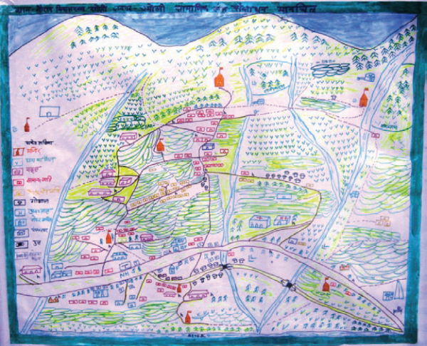
Village mapping: a strategy for collaboration and community empowerment, COMDEKS India
One of the unfortunate consequences of the migration of men away from area villages is that managing the landscape has become an increasingly female task. Land management adds an additional dimension to the many challenges that women face. Women are responsible for securing fodder for cattle, fuel wood for cooking, and water, which are all found far from the village. The involvement of women in the agricultural workforce is an essential aspect of food security in present day Uttarakhand.
In addition to agriculture and remittances, tourism is also important to the local economy of the mountain region, with major Hindu temples and holy sites attracting both pilgrims and tourists to the area.
Key Environmental and Social Challenges
As might be expected, mountain livelihoods that once existed within a well-balanced landscape have come under pressure with the passage of time and increasing population density. The changing demographic and economic conditions have not only disrupted livelihoods but have also increased pressure on natural resources, further impacting family life and driving out-migration. Lack of local infrastructure and weak understanding by policy makers of the hardships of mountain life has further aggravated the situation. While reasons for this degradation over time can be attributed to many factors, the following constitute the major reasons for this changed scenario over the years:
- Restrictions on the forest-based livelihood options traditionally available to communities.
- Lack of access to technology and sufficient credit to allow communities to invest in the production of value-added forest and nature-based products.
- Human-animal conflicts that disrupt agriculture, due to the depletion of forest habitats and the consequent ingress of wildlife into farm areas.
- Lack of appreciation of the importance and relevance of local biodiversity, matched with pressing survival needs that encourage activities that degrade local ecosystems.
- Climate change and shifting weather patterns.
- Pressure to increase immediate income from agriculture, leading to the replacement of multi-crop horticulture-based systems with more mono-cropping landscape systems of paddy-wheat crops.
- Centrally devised initiatives for integrated rural development and related livelihood support that have weak relevance to mountain scenarios.
- Poor infrastructure and connectivity, as well as the lack of efficient linkage to markets, resulting in higher input and output costs for agriculture.
- Outward migration driven from a need to insure a decent living standard.
COMDEKS Activities, Achievements, and Impacts
Community Consultation and Baseline Assessment
“COMDEKS is empowering poor communities cut off from the mainstream by rivers for 3-4 months of the year. It is creating impacts on their livelihoods through a range of actions, such as improving cultivation to inhance income and introducing energy efficient technologies to resuce the use of fuel wood and reduce pressure on forests.”
–Arijit Banerjee, President, Friends of the Doon Society
Community consultation to assess baseline conditions in the landscape and identify potential opportunities for community action took place through field visits conducted at eight different locations (at least 50-70 km apart from each other) within the state, involving a total of 150 people. At these visits, community members were asked to participate in the identification of increased pressures on natural resources and mountain communities. An important part of the community consultation was a mapping exercise in each of the participating villages to list and locate the critical local natural resources and identify who had access to these resources. Feedback gathered at these consultations was later followed up with a one-day workshop, during which 112 community representatives scored and discussed the resilience indicators developed by Bioversity International and the United Nations University. The main areas of concern emerging from the baseline assessment included the loss of productive land due to forest fires, soil erosion, and threats from wild animals; soil and water degradation from industrialization; and a shortage of labor from migration. Poor market linkages and lack of awareness of best management practices have also contributed to the loss of biodiversity and the economic hardships that residents are facing, according to the assessment.
Landscape Strategy
Community input from the village consultations and workshops informed the design of the COMDEKS Country Programme Landscape Strategy for India. Table I-1 shows the four Landscape Outcomes around which the strategy is built, as well as the performance indicators that will be used to measure these outcomes.
Table I-1: Landscape Outcomes and Indicators from the India Landscape Strategy
| Landscape Outcomes | Key Performance Indicators |
| Outcome 1:
Enhanced provision of ecosystem services within the target landscapes through conservation activities and sustainable use of natural resources. |
· Number of hectares of degraded ecosystems in the landscape brought under sustainable resource management, restored, or rehabilitated. · Number of communities demonstrating sustainable land and forest management practices. |
| Outcome 2:
Improved agricultural productivity in the target landscape by promoting sound and sustainable agricultural practices, resulting in increased food security and income generation. |
· Number of hectares where more sustainable land use practices is implemented by type. · Number of farm groups/communities and farmers (disaggregated by gender) participating in adoption of appropriate technologies and systems, including crop diversification, agro-forestry, irrigated agriculture, conservation farming, low cost renewable technologies for drying, and energy efficiency technologies, mixed farming-livestock systems, etc. |
| Outcome 3:
Alternative livelihood options promoted within the landscape to enable access to markets and local financial institutions. |
· Number of alternative income sources created through livelihood diversification (i.e. dairying and ecotourism). · Number of participating community members (gender disaggregated) benefitting from project activities. |
| Outcome 4:
Institutional systems strengthened at the landscape level by promoting sharing of knowledge and information on effective use of resources and landscape-related issues, and more participatory decision making in the target landscapes. |
· Number of community-based institutions created or strengthened that engaged in integrated landscape management. |
To achieve these outcomes, communities will be guided by the following principles in their choice of local activities:
- Promote respect for biodiversity and ethnic values to help restore the balance between people and nature. Reviving cultivation of traditional food crops will be part of this strategy, which is also more suitable to the small land holdings that are common in the area.
- Address the decline of agricultural productivity. Sustainable agriculture must be approached from a livelihood and food security perspective, with an understanding of the unique resources and challenges of mountain communities.
- Enhance support to women, who are a potent workforce in the hills. Projects should reflect the fact that women stand at the heart of the landscape in terms of their livelihood responsibilities and key role in environmental management.
- Tap niche areas for income generation, enterprise development, and potential to serve local markets. Potential areas to explore include tourism, niche crops, handicrafts, health foods, organic produce, dairying and floriculture.
- Create a strong knowledge capture and sharing system. Capturing lessons learned will improve understanding of landscape dynamics, stakeholder livelihoods and needs, and governance requirements.
- Create local institutions for sustainable practices and convergence. Emphasis will be given to the facilitation of local kinship and area-based people’s institutions.
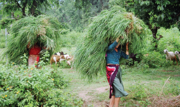
Women cut and carry livestock forage, COMDEKS India
Community-Led Landscape Projects
To date, the COMDEKS India Country Strategy has a portfolio of six local projects, supported by small grants of US$32,000 to $36,000 to six local CBOs and NGOs (see Table I-2):
Table I-2. COMDEKS Community-Led Projects in Uttarakhand Region, India
| Project | Grantee (CBO/NGO) | Contribution to Landscape Resilience Outcomes | Description |
| Alternate/Renewable Energy for Sustainable Land and Resource Management | Lok Paryavaran Shiksha Sansthan (LPSS)
US$34,300 |
Outcomes 1, 2, 3 | Enable 1500 households in the Juanpur Valley to adopt alternative energy technologies such as micro-hydro, biogas and improved cookstoves to support creation of local small enterprises and improve household health conditions. Provide skills training for women in tailoring as alternative employment; introduce fodder and vegetable seeds for better farm management, nutrition and higher farm incomes. |
| Conserving Biodiversity for Positive Human-Nature Relationship through Nature and Tourism in Kausani District of Almora District | Mahila Haat
US$32,600 |
Outcomes 2, 3, 4 | Promote ecotourism by local providers in the Kausani valley region through training and organizing guides, porters, and cooks, and obtaining their recognition by the Forest Department, creating local craft and service enterprises to cater to tourists, improving trek routes, and creating other tourist infrastructure, and organizing the community through public meetings and creation of self-help groups. Promote home kitchen gardens and value-added crops such as spices and fruits to increase farmer incomes. |
| Creating Resilient Communities in a Landscape Approach through Institutional Strengthening in the Tarikhet Block | Chhatrasal Sewa Sansthan (CSS)
US$34,500 |
Outcome 3 | Promote dairying and other livestock-based livelihoods through herd improvement, veterinary care, fodder improvement, strengthened management, biogas installation, and market expansion. Promote value-added processing and packaging of local cash crops like turmeric, red peppers, garlic and ginger, as well as better market linkages. |
| Daluwala Kalan Gram Panchayat Community Landscape Development Initiative
|
Friends of the Doon Society (FODS)
US$34,900 |
Outcomes 1, 2, 3 | Support Tongia Cultivators, a community living inside Rajaji National Park, to adopt sustainable farming methods and a variety of energy alternatives to reduce pressures on the park. Provide skills development in tailoring, rug making, and computer data entry for women and poor families to increase income opportunities and raise living standards. |
| Sustainable Landscape Development through Eco-tourism Based Livelihood Promotion in Himalayas | Alaknanda Ghaati Shilpi Federation (AAGAAS)
US$36,300 |
Outcomes 2, 3, 4 | Develop local economy through training in organic farming and food processing; establishment of nurseries for fruits, herbs and medicinal plants; establishment of an Ayurvedic Herbal Therapy facility; and promotion of local bamboo and nettle crafts, including opening local shops run by community institutions to allow direct marketing of local crafts. |
| Value Addition of Fruits, Vegetables and Herbs for Income Enhancement | Central Himalayan Rural Action Group (CHIRAG)
US$33,700 |
Outcomes 2, 3, 4 | Promote crop diversification with a mix of food crops, horticulture, floriculture, and the culture of herbs and aromatic plants. Improve market access and capture more value through local fruit and vegetable processing, including creation of a community-managed fruit processing center. |
Achievements and Impacts to Date
Lorem ipsum dolor sit amet, consectetur adipiscing elit. Ut elit tellus, luctus nec ullamcorper mattis, pulvinar dapibus leo
- Continuing community consultation to increase local ownership and empowerment of women: In all six project locations, there has been an attempt to keep the consultation process begun in the baseline assessment alive and make it an active part of project implementation through participatory rural appraisals and frequent village meetings. In all, 134 village meetings—some 20-30 per village—have occurred since the project planning process started. These continued consultations have been particularly empowering to women, who have used them as an organizing platform to form 36 self-help groups involving nearly 750 members since 2013. These groups make their own decisions, document them in village meetings, and have participated in the local projects at every level. They have also opened bank accounts and mobilized a total of approximately US$3,600 to contribute to local project activities as community co-financing. Such community contributions, as well as the chance to share responsibilities for both planning and implementing projects, has resulted in a greater feeling of ownership at the community level for the project outcomes.
- Capacity enhancement to open up new livelihood opportunities: A total of 48 training and capacity building workshops have been conducted to date. These cover a broad range of technical skills from setting up solar stations, to adopting organic farming practices, to animal husbandry, to dairy management, to processing herbs, medicinal plants, and low-quality fruits, to tailoring. For example, in the area around Rajaji National Park, six trainings on sustainable agriculture and nursery development took place, while in the Kausani Valley, ecotourism training was provided, including instruction in being a nature guide, providing hospitality, and sanitary food preparation. Training in traditional choolia and jhora dance has also been provided to a newly formed cultural group who will find employment by providing entertainment in local tourist hotels. A new facilitation center in the Kausani Valley now provides instruction in local arts and crafts production for the tourist trade, such as knitting and production of jams and fruit juices. Training in craft weaving of Himalayan nettles has resulted in new enterprises in three villages, while training in and promotion of bamboo crafts has produced eight new designs and increased sales.
- Constructing energy and enterprise infrastructure and introducing appropriate technologies: On a number of different fronts, small infrastructure projects have been completed to provide new energy services and give communities the capability to start local enterprises. For example, two milk centers to support dairy farming were completed in the Haldwani District, benefitting 125 families. These worked hand in hand with breed improvement efforts and the adoption of better animal husbandry practices. In addition, three training and food processing facilities were completed in the Chamoli District, and a Community Facilitation Center consisting of a cafeteria, information center, and other facilities to support ecotourism is under construction in the Almora District. In other districts, low cost and easy to handle food processing technologies have been introduced, as has the use of poly-houses for vegetable culture. On the energy side, nine biogas digesters have been constructed within the last nine months in various locations, while mason work on five power generating water mills has been completed, with final installation of the power units to come. In addition, 16 water mills for grinding grain have also been built. These facilities have enabled communities to commence new income-generating activities and take advantage of the skills training they have received, in addition to cutting their use of wood fuels.
- Creating linkages with government to support local projects: NGOs and CBOs directing local projects have interacted on a regular basis with relevant state authorities, including the Agriculture, Animal Husbandry, Tourism, Horticultural, Renewable Energy, and Forest Departments, as well as the State Agricultural Banks, Medicinal Plants Board, and Biodiversity Board. This has cultured a sense of mutual understanding and respect and created a context in which state departments are anxious to provide key areas of technical support. For example, the state Ecotourism Board has contributed to the ecotourism project in Almora District by providing master trainers as well as communicating state ecotourism guidelines. Similarly, the Uttarakhand Forest Department has linked with efforts in the Chamoli District to promote local handicrafts by offering to buy local nettle crafts for resale through the State Forest Department Board. This approach has also helped local groups to access enterprise subsidies from various national and state government programs.
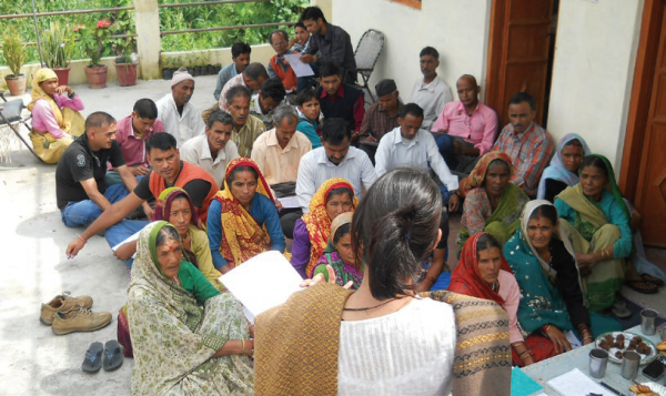
Residents meet for village discussion, COMDEKS India
Progress at the Landscape Level
A stress on sustainable enterprise development, creation of alternative income streams for those living near parks, and adding value to current agricultural efforts while making them more environmentally sound marks the overall approach among the project portfolio in Uttarakhand, where expansion of livelihood options and the empowerment of marginalized communities are seen as critical themes. To accomplish this, projects are being institutionalized through a large number of local resource user and self-help groups, with a particular emphasis on women’s self-help groups such as saving and credit groups. In this beginning phase, the emphasis is on firmly establishing individual groups, with coordination among groups not yet the most important consideration. Nonetheless, regular meetings among the NGOs leading the projects and increased contacts between communities for the purposes of skills training and knowledge sharing is now beginning to create a network of actors conscious of complementary activities throughout the target landscape. All the projects are also being networked with the National Watershed Programme, which will link them with technical and political support at a larger level. Still, the development of a functioning “landscape community” is in its infancy. Communities and project activities are physically quite isolated—separated from each other by a distance of 25-45 km in mountainous terrain—posing a challenge to the development of a larger landscape-wide identity. While community members have embraced the integrated approach of the COMDEKS activities, it will require more time for the socio-economic benefits of the approach to become clear and the connections between these enterprises and new agricultural patterns to emerge in a dynamic way.
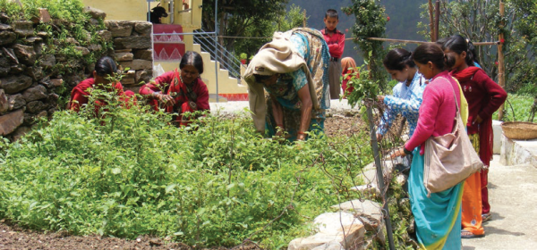
Home gardens enhance food security, nutrition and income, COMDEKS India
Lessons Learned
- The village mapping exercise at the beginning of the baseline assessment was found to be an essential tool to create a base of understanding among community members about the extent, location, status, and usage of local natural resources. It gives the community clear insights into the social structures existing in the village—such as the role of kinship and the local power structure—and how they affect access to resources. The exercise itself is also very empowering for the whole community, particularly the poor, giving a range of local men and women of different backgrounds, education, and castes an opportunity to come together and agree on facts on the ground, to be used as a basis for negotiating a community plan. Although time-consuming to produce, the maps are highly valued as a community resource and are often kept in a common place in the village and displayed prominently as a reference document. In addition, the act of mapping is an important prelude to the development of a regular regimen of resource and project monitoring conducted by community members to assess progress against commitments and goals.
- Mapping exercises also build vision, rapport and mutual trust between different stakeholders, clarifying the roles they need to play for the success of the project. It is a tool which produces a blend of people’s local knowledge and the modern knowledge base on a range of issues. This lends greater empowerment and recognition of people’s knowledge and creates more interest for people to participate and share benefits from a range of actions agreed during the mapping exercises.
- The resilience indicator scoring exercise was crucial to building community understanding of the landscape concept. Local NGOs and community members used this baseline exercise as a forum where they could discuss issues relating to forest use, agriculture, water resources, and the landscape changes highlighted by the different indicators. The detailed discussion on their landscape and its components allowed participants to make connections they usually did not make between actions in one part of the landscape and effects on another. For example, communities previously had not paid attention to the relation between deforestation and soil erosion on farm land, since they seemed to be two separate spheres. However, the indicator scoring exercise gave them the chance to understand the link.
- Regular and timely village meetings are very helpful in building a rapport and mutual respect and trust between the NGO managing the local project and community members. These regular meetings are essential to keeping the community engaged and thus ensuring the sustainability of the project. They are also a crucial means of enhancing the skills and capacities of a range of community volunteers to plan, implement, manage, and monitor resources and activities according to the agreed work plan. This helps to build a long-term vision and willingness to pursue activities that will produce higher incomes. Also helpful is establishing a community contribution agreement specifying what costs the community will share from its own money and what community members’ roles will be in the project.
- Some projects have successfully utilized community “wealth ranking” exercises, where communities decide which households belong to different wealth categories, so that some project benefits can be specially targeted to poor households, addressing community inequities. This process of locally defining social inequalities and wealth categories has proved to be an effective method of tackling a delicate subject and avoiding conflicts surrounding the distribution of project benefits.
- Informal, issue-based groups, such as forest groups, livelihood activities groups, and women’s self-help groups, have proven to be essential in organizing project activities, gaining buy-in from different segments of the community, and enhancing governance skills within the community. To be effective, the purpose of forming these institutions needs to be clearly understood by those involved and not imposed by NGOs or COMDEK partners. Saving and credit groups have been an especially effective way of putting development capital in the hands of women for livelihood actions. Many of these groups are linked with commercial banks, magnifying the availability of credit for local enterprise development.

