Cambodia: Paddy rice cultivation and freshwater fishing industry in the Mekong and Tonle Sap Rivers

06.03.2012

  • SUBMITTED ORGANISATION :

  • United Nations University Institute for the Advanced Study of Sustainability (UNU-IAS); Japan Wildlife Research Center (JWRC)

  • DATE OF SUBMISSION :

  • 06/03/2012

  • REGION :

  • South-eastern Asia

  • COUNTRY :

  • Cambodia (Mekong and Tonle Sap Rivers)

  • SUMMARY :

  • This study was commissioned to be included in the publication “Socio-ecological Production Landscapes in Asia”. This chapter provides an overview of paddy rice cultivation and freshwater fishing in the area.

  • KEYWORD :

  • Rice paddy cultivation, fish, inland water

  • AUTHOR:

  • Japan Wildlife Research Center (JWRC); Kaoru Ichikawa (UNU-IAS), ed.

  • LINK:

  • http://collections.unu.edu/eserv/UNU:5448/SEPL_in_Asia_report_2nd_Printing.web.pdf

Summary Sheet

The summary sheet for this case study is available here.

Background

[Note: this case study originally appeared in the publication Socio-ecological Production Landscapes in Asia.]

According to the Köppen climate classification, the largest part of Cambodia is classified as tropical savanna. The country has less precipitation than other countries in Southeast Asia. However, more water than the total amount of annual rainfall in the whole country is brought to Cambodia via the Mekong River. The water fills a wide plain in central Cambodia and then runs into the South China Sea. The change of water by season is a major climatic characteristic in Cambodia (Amakawa, 2004) The Mekong River is a large river whose source watershed is the Tibetan Plateau, which has an altitude of 5,200 meters. From there, the river flows nearly 4,000 km to reach Cambodia. Basins of the Mekong and Tonle Sap Rivers cover approximately 40% of the total land area of 180,000 km2, and the Mekong River joins the Tonle Sap River, which is connected with Tonle Sap Lake around Phnom Penh.

The Tonle Sap Lake (with an altitude of five meters) is one of the largest tropical lakes in the world, spanning 1.4 million ha in the rainy season. In the dry season, water in the Tonle Sap Lake flows into the Tonle Sap River. In the rainy season, the risen water in the Mekong River goes upstream to the Tonle Sap River, and the lake expands (Table 1). The flood plain includes flooded forests, shrub forests and grassland. It is abundant in food for fishes such as zooplankton and phytoplankton, floating algae, water bugs that grow in the water, and sunken grass, leaves and insects (Nakahara et al, 1996). Therefore, Tonle Sap Lake is a freshwater fishing ground that boasts large catches. Tonle Sap Lake is like a huge pool that rapidly expands in the rainy season. The water areas, including paddy fields, have abundant ecological resources.

Table 1. Characteristics of Tonle Sap Lake in the dry and rainy seasons

Characteristics of Landscape and Agriculture in the Basins of Mekong and Tonle Sap River

Rice Cultivation

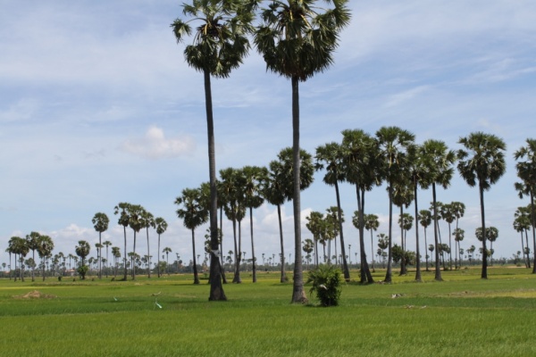
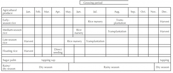
The characteristics of the landscape around the Mekong and Tonle Sap river basins, which contain the flood plain of Tonle Sap Lake, the size of which contracts or expands in a vast, flat land, include the rain-fed paddy fields in which ordinary rice is cultivated, paddy fields around the outer border of the high water area, high water paddy fields for the cultivation of floating rice, and a floating village. The staple food is rice, and fish is one of the important foods in Cambodia. Local residents engage in paddy rice cultivation and freshwater fishing according to the seasonal changes in the water levels. Paddy rice cultivation is characterized by cultivation systems that are adapted to the expansion and contraction of the flooded area. Ordinary rice is cultivated in the outer area and in rain-fed paddy fields with an increased water level of less than around one meter, and floating rice in the area with an increased water level of two meters or more (Kobayashi, 2004). Sugar palms (Borassus flabellifer) are scattered in rain-fed paddy fields (Photo 1), not in the high water area (Photo 2; Table 2). For example, in Sankor Distict, Kampong Svay County, Kampong Thom Province, floating rice is directly seeded in April and harvested at the end of December or in January (Table 3). Seedbeds of ordinary rice are prepared around the end of May, when the rainy season begins (Kobayashi, 2004), and harvesting starts in November. Varieties of ordinary rice can be chosen from early-season, medium-season and late-season. In general, the yield of late-season rice is higher than that of early-season rice but farm households prefer to cultivate multiple varieties. It is considered that this is to adjust the time of each farm work process according to the varietal characteristics of rice by intentionally delaying the time of planting and harvesting that require a large amount of labour, and to secure the period of having enough rice for personal consumption (Tanikawa, 1997).

Photo 1. Borassus flabellifer (Sugar palm) scattered within rain-fed paddy fields (Photo: Japan Wildlife Research Center)

Photo 2. High-water area in the dry season (Photo: Japan Wildlife Research Center)

Table 2. Landscape elements surrounding Tonle Sap Lake

Source derived from materials by Kobayashi 2004, and Kobayashi 2007

Table 3. Agricultural calendar around the north part of the Tonle Sap Lake

Source: Tanikawa (1997)

Freshwater Fishing

According to the survey (Tanikawa, 2001) conducted in a village near Siem Reap City (located in the north part of Tonle Sap Lake), the area has a large production volume of rice in rain-fed paddy fields but the production is unstable due to the change in precipitation. As a measure to cope with the shortage of rice, farmers are engaged in various works such as sugar production from sugar palms, breeding domestic livestock, including cattle, pigs, chickens, etc., making souvenirs for visitors, reparation and construction works in the Angkor ruins in the vicinity, etc.

For most farmers living around the flood plain, an important income source in the dry season is small-scale freshwater fishing. For example, in two villages (183 and 140 households respectively) in the Kampong Thom Province, fishery production is conducted around Tonle Sap Lake and the surrounding area of the villages (ponds, rivers, flooded forests, rice paddies). Fish catches are therefore higher in Tonle Sap Lake. Even in the fisheries industry around the villages that have small fish catches, the self-consumption rate is only 5 to 10% and most catches are for sale. Some farmers travel 25 km from their home village to a floating village to do fishing on Tonle Sap Lake as a side job for almost 9 months (from October to June) during the dry season (Hori et al., 2005).

People who are mainly engaged in fishery are the residents of floating villages (Photo 3). The size of floating villages varies and large ones have 1,000 to 2,000 households and a population of 5,000 to 10,000 or more. There are 170 floating villages in 23 communes in the whole Tonle Sap Lake area, where approximately 100,000 people live (Kasai, 2003). Houses in floating villages are stilt houses that can cope with drastic changes of water depth, and boat/raft houses that are built on top of boats. These houses are roofed with light materials such as corrugated iron, thatches or shingles. In a floating village, there are private houses, gas stations, fish processing factories, ice-making factories, a government office, school, restaurants for foreign tourists, a branch of the provincial fishery office, etc.

Photo 3. Floating village: Kampong Phluk (Photo: Japan Wildlife Research Center) Source: Tanikawa (1997)

Challenges and Responses

In Cambodia, when farming villages entered the market economy in the 1990s, the degradation of the resources rapidly accelerated. The society is now facing a significant increase in population. Abundant ecosystems around Tonle Sap Lake have long provided important resources to maintain the daily life of poor residents in villages in Cambodia. Today, however, residents are unable to find a solution to their own poverty problems by relying on the resources of the lake alone.

Some of the challenges concerning the management of natural resources around Tonle Sap Lake are the modernization of fishing techniques, the significant decrease of flood forests and the increase in population in the area. Flood forests are cut down to be used as fuel wood for residents. The deforested land is converted to farmland, and the area of flood forests has decreased to a quarter of its peak, which was as large as one million ha (Kasai, 2003). As a response, from around 2000, the Cambodian government has been promoting community fisheries as a measure to cope with issues including sustainable and fair management of fishery resources in Tonle Sap Lake, the improvement of life standards and poverty. Problems such as the decline in resources and deterioration of ecosystems are being recognized by local residents (JWRC, 2009).

References

Amakawa, N. 2004. “Income and Labor in Rural Villages of Cambodia – A Case Study of Rainy Season Rice Cropping in a Village in Kampong Speu Province”. Cambodia in a New Era, Research Library No. 539. Amakawa, N. ed. Institute of Developing Economies (IDE-JETRO), p.327-377.

Hori, M.; Ishikawa, S.; Kurokura, H.; Ponley, H., Somony, T.; Vuthy, L; Thuok, N. 2005. “Household Study of Small-scale Fisheries in Kompong Thom Province, Cambodia”. Materials developed by Tanji Research Team. http://mekong.job.affrc.go.jp/051111Tanjiteam. pdf .(accessed 2011-09-19), p.173-181.

Japan Wildlife Research Center. Community Fisheries of Tonle Sap Lake in Cambodia. 2009. “Fiscal 2008 Report on Commissioned Projects for SATOYAMA Initiative”, p. 95-111. http://www.env.go.jp/nature/ satoyama/syuhourei/pdf/cwj_9.pdf. (accessed 2011- 09-19)

Kasai, T. 2003. Preliminary review on environmental preservation in the Tonle Sap Lake area, Cambodia. Ritsumeikan Journal of International Relations, 21, p.41-64. http://www.ritsumei.ac.jp/acd/ re/k-rsc/ras/04_publications/ria_ja/21_03.pdf. (accessed 2011-10-29)

Kobayashi, S. 2004. “Current Situation of Working and Making a Living in Villages in the Eastern Tonle Sap Region, Cambodia – A Case Study in Sankor District, Kampong Svay County, Kampong Thom Province”. Cambodia in a New Era, Research Library No. 539. Amakawa, N. ed. Institute of Developing Economies (IDE-JETRO), p.275-325

Kobayashi, S. 2007. Agricultural land right resolution process in post-Pol Pot rural Cambodia: a case study from the eastern Tonle Sap region. Asian and African Area Studies. 6-2, p.540-558. http://www.asafas. kyoto-u.ac.jp/publication/pdf/no_0602/540-558.pdf. (accessed 2011-10-31)

Nakahara, H.; Yoshida, Y.; Ajisaka, T. 1996. “Fisheries in the Tropics”. Tropical Agriculture. Watanabe, H.; Sakuraya, T.; Miyazaki, A. eds. Asakura Publishing Co., Ltd., p.146-157.

Oyagi, H.; Endo, S.; Okumura, Y.; Tsukawaki, S.; Mori, K. 2009. Characteristics of water temperatures in Lake Tonle Sap, Cambodia. Proceedings of the Institute of Natural Sciences, Nihon University. Geography, 44, p.167-176.

Tanikawa, S. 2001. “Sketch of a Village in Cambodia – Ruins and Residents”. Angkor Ruins and Sociocultural Development. Tsuboi, Y. ed. Rengo Shuppan, p.159- 196.

Tanikawa, S. 1997. Village of northwestern Cambodia 1: basic tesearch of socio-economics for North Srah Srang village. Journal of Sophia Asian studies. 15, p.219-258. http://repository.cc.sophia.ac.jp/dspace/ handle/123456789/5167. (accessed 2011-10-29)

Tsukawaki, S. 2001. “Angkor Ruins and Tonle Sap Lake”. Angkor Ruins and Sociocultural Development. Tsuboi, Y. ed. Rengo Shuppan, p.119-144.