Objective of program
l Understand the size of disturbance caused by 11th March tsunami and its impact on the local ecosystems.
l Detect the facilitation factors and human disturbance factors for ecosystem recovery.
l Offer the information about suitable land use for renaissance and also about mechanism of ecosystem and biodiversity, which is critical for business promotion to local population and county.
l Through the above, Earthwatch Japan will help to create a system that enable the locals to use ecosystem functions and services.
✻ Tohoku University has data on the ecosystems in these brackish tidal flats, rice paddies and islets before the tsunami hit that allow the comparison of condition of ecosystems before and after the tsunami.
- Outline of the projects
i. Monitoring the influence of earthquake and tsunami on brackish tidal flat ecosystem
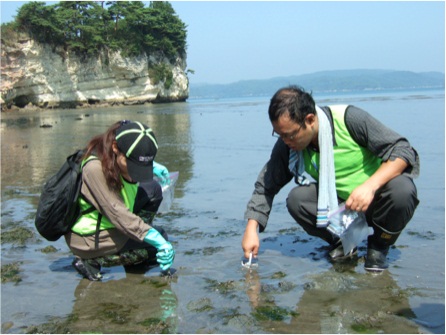
l Search the surface ground of fieldwork site for 15 minutes and collect living organisms into plastic bags.
l Dig into the ground 15 times and collect living organisms into plastic bags
l Identify species of the collected-organisms and record them.
l Evaluate biodiversity condition of the tidal flat
The ratio of species on the recording sheet to found species shows their usefulness as habitats for organisms
fig1,fig2
➙ Identify the undamaged habitats by comparing the before and after results of the tsunami; the collected data is applied for evaluation of level of disaster damage.
➙Identify the level of recovery and disturbance factors by observing the growth of benthos.
➙ Identify invasive non-indigenous species at early stages and apply to restoration of brackish tidal flat ecosystem
➙ Encourage the development of symbiotic relationships between nature and local population and environmental literacy of local people
- Monitoring of ecosystem in Matsushima Islet
fig3,fig4
l Monitoring the environment of the beach, marsh and rice paddies
Investigate the beach, marsh and rice paddies that are thought to have had the biggest damage from the tsunami. In this research, check whether the change in vegetation is related to recovery of the ecosystems or not.
The investigation is carried out with quadrat survey on island plots.
l Study on undamaged nature
Create a nature map of Urato Islands based on the data obtained from this investigation and record the change of natural environment. The investigation of flora and fauna is carried out around hiking course by using line census method.
l Monitoring diversity of butterflies
Observe the changes of vegetation caused by the earthquake and tsunami and monitor the impact on the change in diversity of butterflies. Record name of species and number of butterflies taken at research plots.
➙To identify the recovery process of biodiversity in the islet.
➙To support revival of the local communities by discovering and conserving tourist attractions such as nature and biodiversity of the islet.
- Monitoring the rice paddies hit by the earthquake and the tsunami
Understand the impact of the earthquake and tsunami on rice paddies and identify the facilitation and hindrance factors for environmental recovery by tracing process of natural recovery of the environment.
fig5,fig6
Carry out seasonal monitoring survey on plants, aquatic insects, fish and amphibians in 10-25 different rice paddies, which are at different stages of recovery work from tsunami damage. From this survey, identify changes of biota in different rice paddies.
➙ Identify factors that caused differences in size of impacts caused by tsunami, on ecosystems and influence of biota from comparison of the survey results.
➙ Identify the facilitation and hindrance factors of recovery of rice paddies ecosystems
➙ Share the outcome obtained from this research between the parties involved and raise environmental literacy of citizens that will lead to promotion of healthy, sustainable rice paddies over the long-term.
- First trial research at Urato Island(August 12 to 14,2011)
Trial Monitoring Survey of Ecosystem in Katsura-jima Island & Sabusawa-jima Island (the Urato Islands)
The Urato Islands, which consist of four inhabited islands and a number of uninhabited islands, are located around the entrance of Matsushima Bay. It is said that these islands weakened the 3.11 tsunami entering the bay, and thus Matsushima, one of the “Three Prominent Views of Japan,” and Shiogama, which is one of the major fishing ports in Japan suffered less from the tsunami compared to other coastal areas. Instead, many of the Urato Islands were severely damaged, and rebuilding work is delayed partly because they are not accessible by land transportation.
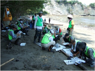
On Aug. 12-14th, 2011, following the aims of the Declaration of the Green Rebuilding from the Sea and Rice Paddy, Tohoku University conducted a trial monitoring survey of ecosystems in the Urato Islands, in association with Earthwatch Japan. Because the university was monitoring the ecosystems in the islands before March 11, it is possible to compare the data before and after the earthquake and tsunami. Nearly 30 people, including 15 volunteers, corporate workers, NPO/NGO staff, and researchers, participated in this research.
Tohoku University and Earthwatch Japan will start a full monitoring survey next year, based upon the experience and result of this trial. The results of this trial survey will be announced as the compilation and analyses of the collected data are completed.
References: References and bibliography
Tohoku University
http://gema.biology.tohoku.ac.jp/green_reconst/TOP.html
Figures, tables and photos: All figures, tables and photos should be cited in the text


