South Korea: Traditional Rural Landscape “Maeul”
06.03.2012
-
SUBMITTED ORGANISATION :
-
United Nations University Institute for the Advanced Study of Sustainability (UNU-IAS); Japan Wildlife Research Center (JWRC)
-
DATE OF SUBMISSION :
-
06/03/2012
-
REGION :
-
Eastern Asia
-
COUNTRY :
-
Republic of Korea
-
SUMMARY :
-
This study was commissioned to be included in the publication “Socio-ecological Production Landscapes in Asia”. This chapter provides an overview the traditional “maeul” agricultural landscape of the Korean Peninsula.
-
KEYWORD :
-
Agriculture, secondary forest, abandonment
-
AUTHOR:
-
Japan Wildlife Research Center (JWRC); Kaoru Ichikawa (UNU-IAS), ed.
-
LINK:
-
http://collections.unu.edu/eserv/UNU:5448/SEPL_in_Asia_report_2nd_Printing.web.pdf
Summary Sheet
The summary sheet for this case study is available here.
Natural and Social Background
[Note: this case study originally appeared in the publication Socio-ecological Production Landscapes in Asia.]
While the northern part of South Korea, which extends from north to south, has a cold climate with little rain, the southern part, situated in the temperate zone, is warm and has a high rainfall regime affected by the ocean. The country has two thirds of its land covered with forests. The characteristic forest vegetation of South Korea consists of Pinus densiflora, Quercus spp, and Aceraceae, and most of the forests close to settlements and agricultural land are dominated by Pinus densiflora . Since the entire country was devastated by the Korean War, which began in 1950, there are many secondary forests, which are 30 to 40 years old. Agricultural land accounts for about 18% of the national land, distributed mainly in the southwestern part of the country, and 60% of it is accounted for by paddy fields (Republic of Korea, 2009).
After the end of the Korean War, South Korea began to achieve rapid economic growth in the 1960s. The government formulated the first and second fiveyear economic development plans, which covered the period from 1962 to 1972, but since these plans focused on industrialization, physiocratic agricultural policies were abandoned one after another with spending on the agricultural sector remaining at only around 20% of total fiscal investments (Han, 1988). As a result, the proportion represented by the agricultural sector in the total working population, which stood at 60.6% in 1963, fell to 49.5% in 1970, and the percentage of the gross national product accounted for by agricultural production decreased from 39.4% to 25.2% during the same period. The ratio of the income of farmers to the income of workers in urban areas (non-farmer income) declined from 80.6% in 1966 to 67.1% in 1970, generating a regional imbalance in income (Han, 1988). In order to solve rural problems such as the regional imbalance in income that resulted from the advancement of industrialization and the influx of people into the cities and to achieve the balanced development of regional communities and the lives of their residents, the Saemaeul movement was established as part of the priority measures taken to develop agricultural and fishing villages under the third economic development plan, which began in 1972 (Han, 1988).
After the declaration of democratization in 1987, the roles of local governments underwent major changes as local autonomy was restored. Up to that time, the central government had led regional development, but it shifted its policy from positioning local governments as organs that executed the central government’s projects to allowing them to independently develop and implement administrative plans designed to revitalize rural areas. Since this shift, projects aimed at encouraging local residents to take the initiative in promoting and enlivening regional economies have replaced the previous rural policies that focused on infrastructure development (Son, 2008).
Characteristics of Agricultural Landscape “Maeul”
Rural Landscapes and Feng Shui
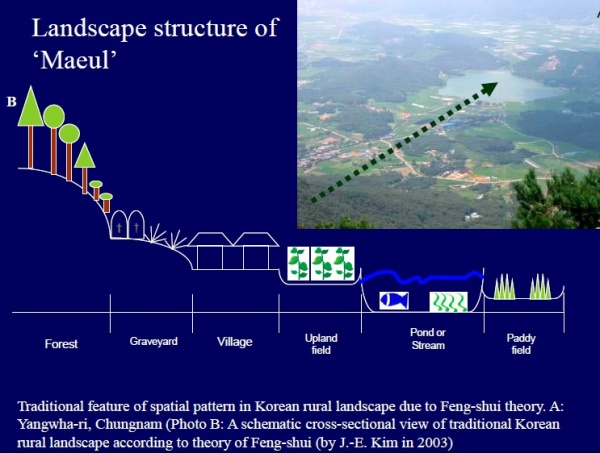
Source: Hong, 2009. SATOYAMA Initiative International Workshop Realizing Sustainable Rural Society in Harmony with Nature Presentation materials.
In South Korean rural areas, land use is characterized by a mosaic of secondary forests, cultivated land, paddy fields, streams, irrigation ponds, and so forth, and such rural landscapes, including the settlements (Photo 1), are called “maeul” (Hong, 2009; Hong and Kim, 2011). The guardian deities of a village are considered to live in the mountains that rise behind these settlements, and given that there are examples of altars being built to pray for rain or hold mountain festivals, it is inferred that these deities are worshiped by the local residents. In addition, in each village, there are one or more dangsan, which is a place for the entire village to conduct religious rites (Photo 2). Many dangsan, whose structure varies from one settlement to another, consist of a combination of sacred trees, halls, piles of stones, rocks, stone statues, and other objects, and the sacred trees are often huge or old. Dangsan, which is jointly owned and used by the members of the village, signifies the local union of the members of the village and is an important element that constitutes the cultural landscape of villages (Shibuya, 1990).
The South Koreans have believed in feng shui since ancient times, and maeul is also strongly influenced by Feng-Shui theory (Hong et al., 2007; Hong and Kim, 2011). In olden times, kings and feudal lords used feng shui to select sites suitable for building capitals, castles, and temples. After the middle of the period of the Yi Dynasty (1392-1910), feng shui gradually spread to the general public and came to be considered important when determining sites suitable for the location of houses and graveyards (Nishigaki, 1993). “Feng” refers to the weather and climate, and “shui” relates to everything that is related to water. The South Koreans have believed that fertile land, fresh air, clean water, the fruits of the forest, and other natural blessings are brought by appropriate connections of wind and water (Nakagoshi and Hong, 2001; Hong et al., 2007). In the feng shui tradition, a landform with mountains behind it is considered auspicious. Therefore, a “maeul landscape” has small hills as part of the background and is structured so that it starts with secondary forests on the mountain side and after the forests come graveyards, settlements, agricultural land, ponds, and streams arranged down the slope in this order.
In addition, in South Korea, burial has generally been the practice since the period of the Yi Dynasty, when Confucianism prevailed. The South Koreans believed that their descendents would prosper if they construct graveyards for their ancestors at locations considered favorable in the feng shui tradition, and, based on this belief, they constructed many graveyards in the southfacing lands that lay between the secondary forests and the villages. Graveyards are built by felling the woods, piling up earth, and covering the earth with Zoysia japonica. These traditional landscapes in rural areas are maintained by removing shrubs and weeds that extend out from the neighboring forests and doing repairs to the graveyards once or twice a year. If the graveyards are abandoned due to a fall in the agricultural population and changes in the lifestyles of the villagers, however, the graveyards and their surroundings become wasteland, degrading the traditional landscape and affecting the dynamics of the vegetation (Kim et al., 2007; Hong et al., 1995).
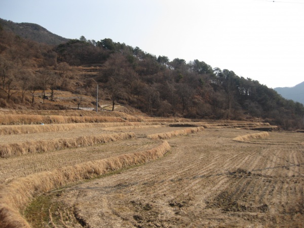
Photo 1. Cultivated land and secondary forests (Photo: Japan Wildlife Research Center)

Photo 2. Dangsan (Photo: Japan Wildrlife Research Center)
The Cultural Heritage Administration of Korea designates the various types of village forest as bangpungnim (windbreak forests), hoannim (forests established along riverbanks or coast lines to prevent floods), eoburim (fish shelter forests) , dangsup (sacred forests), yeoksarim (forests to which historical stories and legends are attached) and the seonghwannim (forests under the tenets of “Feng-Shui” theory) (Hong et al., 2011). Seonghwannim are the secondary forests around the settlements which are developed to make up for the defects in the landforms or geographical features around the settlements, if they are regarded as unfavorable or deficient when seen from the viewpoint of Feng-Shui (Shibuya, 1990). One example is that if the mountains in a certain direction are too low, secondary forests are created in that direction to prevent the winds that disperse moisture from the soil. In this manner, the secondary forests behind or around settlements, which are jointly used as places to conduct religious rites, are important elements that constitute the rural cultural landscape of South Korea, in addition to fulfilling practical functions.(Hong and Kim, 2011).
Changes in the Rural Landscape
Located in South Chŏlla Province in southern South Korea, Teokseong-ri is an ordinary settlement that has paddy fields and secondary forests, two characteristics of rural areas in the country. According to the Statistical Year Book, the number of farming households in Teokseong-ri started to decline sharply in the 1980s, and at the same time, the area of paddy fields decreased. But rice production has continued to grow compared to the 1980s though it fluctuated from time to time. This is because the agricultural efficiency of the settlement improved due to mechanization and the introduction of chemical fertilizers (Kim et al., 2006).
Secondary forests have been used to provide timber, fuel for ondols (traditional underfloor residential heating systems in South Korea), firewood and charcoal, fertilizer, and for other purposes, as well as for the gathering of edible wild plants and mushrooms (Youn, 2009). Human interventions such as cutting off branches and collecting fallen branches and leaves to allow sufficient light to penetrate into the forests, thus promoting the growth of seeds, have contributed to the maintenance of these forest ecosystems (Kim et al., 2006). In the rapid economic growth in the 1960s, however, firewood was replaced by fossil fuels (Youn, 2009), and use of chemical fertilizers were increased, thus decreasing the use of secondary forests. The forest vegetation of Teokseong-ri is mainly composed of Pinus densiflora , Q. mongolica, and a mixed of Pinus densiflora and Quercus spp. Some reports claim that without human intervention, Pinus densiflora forests change into a mixed type of Pinus densiflora and Quercus spp(Kim et al., 2006). At Teokseong-ri, too, the percentage of Pinus densiflora to the total area of forests fell from 47.9% to 30.6% while that of Q. mongolica and other oaks rose. The proportion of lots in which Pinus densiflora were dominant also fell, from 15.3% to 6.7%, while on the other hand, that of lots dominated by Q. mongolica and other oaks rose. As described above, the forest ecosystem in the villages has undergone changes (Kim et al., 2006).
Challenges and Responses
Due to the rise in demand for labor in the industrial sector during the period of economic growth that began in the 1960s, people moved from rural villages to urban areas, substantially reducing the agricultural population. In the 1990s, the market for agricultural products was increasingly opened to the rest of the world, and imports of low-priced agricultural products increased. Partly because of this, the rural economy shrank as rural communities lost their vitality. Even today, agricultural land in South Korea is continuing to decline mainly for such reasons as the conversion of agricultural land due to urbanization and industrialization and an increase in the area of cultivated land that is abandoned due to the ageing of the population caused by the drift of young people and those in their prime of life to the cities. The area of agricultural land declined from 2,298,000 ha in 1970 to 1,715,000 ha in 2010 (You and Iizawa, 2005; Statistics Korea, 2011). The “Sae-maeul” movement, which meant “creating new villages” in the spirit of self-help and cooperation, started on a nationwide scale in the 1970s. This was a movement to modernize farming villages and aimed to improve their economic, social, and cultural status using a maeul as the unit of the movement, thus raising the level of welfare of all rural areas in the country. In addition, a wide range of projects such as improving the living environment, developing the production infrastructure, and increasing agricultural incomes were carried out, and as a result, the income of farmers grew and their living standards improved. In these rural development projects, however, the characteristics of individual agricultural villages and their traditional customs were not taken into consideration as a result of the uniform government-led form of development, and many of the ecological functions of agricultural villages that maintained the natural environment as well as their function of handing down traditional culture to posterity were lost (Cho and Yamaji, 2005). As described above, traditional rural landscapes in South Korea are being lost due to industrialization, urbanization, government-led development, and other factors.
Since 2000, various related ministries have implemented rural area revitalization projects with villages as their units. The “Rural Traditional Theme Maeul” project, which was launched by the Rural Development Administration in 2002, aims to identify outstanding natural landscapes and traditional cultures unique to agricultural villages as well as the knowledge required to maintain these, and then to enliven the lives of farmers and promote urban-rural exchanges through experience, learning, stays with farmers, direct sales of agricultural products, and other initiatives with traditional rural culture as their theme. By 2009, 440 villages nationwide had been registered with the Rural Development Administration. This project is carried out through village meetings based on consultations and agreements made by the residents with the administrative support of provinces and municipalities and with the cooperation of experts (Kim and Ohashi, 2005; Kim and Mitsuhashi, 2009). In 2005, the Ministry of the Environment launched “Ecologically Excellent Village and Ecologically Well-Restored Village” project. This project certifies Ecologically Excellent Villages or Excellent Well- Restored Villages, and certified villages receive a budget from the project’s fund for three years. This system aims to educate local residents in the importance of protection of the natural environment and resource management and revitalize regional economies as agricultural tourism villages (JWRC, 2009). There are still issues to be addressed, however, as shown by the example of Gacheon Darangyi Village, which is located at the southernmost tip of South Kyŏngsang Province’s Namhae County. The landscape consisting of mountains, terraced rice fields, private houses, terraced rice fields, and the sea arranged in this order was recognized as a rural landscape and traditional cultural resource. Since the landscape was designated as a “Rural Traditional Theme Maeul” site in 2002, the number of tourists visiting the village has increased, and the villagers as tourist home operators have economically benefited from the tourism boom, but the truth is that this has not yet contributed to a rise in income for the farmers (Kim and Mitsuhashi, 2009).
References
Cho, Y. and Yamaji, E. 2005. Subjects and directions for creating eco-village in rural village of Korea. Transactions of Rural Planning. 7, p.235-240.
Han, S.J. 1988. On the development of Saemaeul Movement in Korea. Agricultural Economic Papers of Kobe University. 23, p.45-65.
Hong, S.K.; Nakagoshi, N.; Kamada, M. 1995. Human impacts on pine-dominated vegetation in rural landscapes in Korea and Western Japan. Vegetation. 116, p.161-172.¬
Hong, S.K.; Song, I.J.; Wu, J. 2007. Fengshui Theory in Urban Landscape Planning. Urban Ecosystem. 10, p.221-237.
Hong, S.K. 2009. Ecology and Sustainable Use of ‘Maeul’ – the Korean Second Nature. SATOYAMA Initiative International Workshop – Realizing Sustainable Rural Society in Harmony with Nature – Presentation materials. March 6, 2009, Tokyo.
Hong, S.K. and Kim, J.E. 2011. “Traditional Forests in Villages in Linking Humans and the Natural Landscape”. Landscape Ecology in Asian Cultures. Hong, S.K.; Wu, J.; Kim, J.E.; Nakagoshi, N. eds. Springer, p.83-97.
Japan Wildlife Research Center (JWRC). 2009. FY2008 Report on SATOYAMA Initiative Project. p.50-56.
Kim, J.E.; Hong, S.K.; Nakagoshi, N. 2006. Changes in patch mosaics and vegetation structure of rural forested landscapes under shifting human impacts in South Korea. Landscape Ecological Engineering. 2, p.177- 195.
Kim, J.E.; Hong, S.K.; Nakagoshi, N. 2007. “International Trends in Rural Landscape Research for Land Management and Policies”. Landscape Ecological Applications in Man-Influenced Areas: Linking Man and Nature Systems. Hong, S.K.; Nakagoshi, N.; Fu, B.; Morimoto, Y. eds. Springer, p.489-504.
Kim, S.M. and Ohara, K. 2005. Study on green-tourism by rural municipalities in Korea. Summaries of Technical Papers of Annual Meeting Architectural Institute of Japan. E-2, p.617-618.
Kim, J. and Mitsuhashi, N. 2009. A Study on the preservation and practical use of terraced rice fields in Korea. A case study on Gacheon Darangyi Village. Summaries of Technical Papers of Annual Meeting Architectural Institute of Japan. E-2, p.435-436.
Nakagoshi, N. and Hong, S.K. 2001. Vegetation and landscape ecology of East Asian “SATOYAMA”, Global Environment Research. 5 (2), p.171-181.
Nishigaki, Y. 1993. The concept of Feng Shui in Korea. Journal of Architecture and Building Science. 108 (1347), p.32-37.
Republic of Korea, Ministry of the Environment. 2009. “CBD 4th National Report”. http://www.cbd.int/doc/world/kr/kr-nr-04-en.pdf (accessed on July 25, 2011)
Statistics Korea. 2011. Agricultural Area Survey in 2010. http://kostat.go.kr/portal/english/news/1/8/index.boa rd?bmode=read&aSeq=245058&pageNo=1&rowNu m=10&amSeq=&sTarget=title&sTxt(accessed on July 22.
Shibuya, S. 1990. A comment on common facilities in Korean village. The Journal of Ritsumeikan Geographical Society. 2, p.95-102.
Son, K. 2008. The present situation of regional revitalization through urban-rural exchanges in Korea. Journal of OVOP Policy. 1 (4), p.35-48.
You, G. and Iizawa, R. 2005. A study of “Direct Payment for Rice Farming” of South Korea: Review of the questionnaire survey. The Review of Agricultural Economics of Hokkaido University. 61, p.29-39.
Youn, Y.C. 2009. Use of forest resources, traditional forest-related knowledge and the livelihood of forest dependent communities: Cases in South Korea. Forest Ecology and Management. 257, p.2027-2034.