COMDEKS Project: Steung Siem Reap Watershed, Cambodia
06.03.2017
-
SUBMITTED ORGANISATION :
-
United Nations Development Programme (UNDP); Ministry of the Environment, Japan; Secretariat of the Convention on Biological Diversity; United Nations University (UNU)
-
DATE OF SUBMISSION :
-
06/03/2017
-
REGION :
-
South-eastern Asia
-
COUNTRY :
-
Cambodia (Siem Reap Province)
-
SUMMARY :
-
The Community Development and Knowledge Management for the Satoyama Initiative Programme (COMDEKS) was launched in 2011 to support local community activities that maintain and rebuild target production landscapes and seascapes, and to collect and disseminate knowledge and experiences from successful on-the-ground actions so that, if feasible, they can be adapted by other communities throughout the world to their specific conditions. The programme provides small-scale finance to local community organizations in developing countries to support sound biodiversity and ecosystem management as well as to develop or strengthen sustainable livelihood activities planned and executed by community members themselves. The COMDEKS target landscape in Cambodia is the Steung Siem Reap watershed area, located in the northwestern province of Siem Reap, home of the historic temple of Angkor Wat, one of Cambodia’s most significant tourist attractions.
-
KEYWORD :
-
Water, Agriculture, Protected areas, Cultural heritage, Conservation
-
Water, Agriculture, Protected areas, Cultural heritage, Conservation
-
United Nations Development Programme (UNDP)
-
LINK:
-
http://collections.unu.edu/eserv/UNU:6012/communities_in_action_comdeks.pdf#page=40
Summary Sheet
The summary sheet for this case study is available here.
The Landscape
Geography
The COMDEKS target landscape in Cambodia is the Steung Siem Reap watershed area, located in the northwestern province of Siem Reap, home of the historic temple of Angkor Wat, one of Cambodia’s most significant tourist attractions. The watershed covers an area of 362,000 ha, and encompasses a wide range of elevations, from 500 m above sea level in the upstream area of the Phnum Kulen mountain range, to about 15 m in the downstream areas. Rainfall ranges from 1093-1611 mm per year.
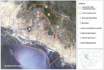
The landscape of the watershed is very diverse. Six distinct zones were identified during the landscape-wide baseline assessment, delineated by topography, rainfall pattern, soil type, land use, forest cover change, and land tenure status. In each of these zones, the relationship between the land, the local communities, and their management practices are somewhat homogenous. These zones are: (1) the Tonle Sap flood plain, (2) the rice-growing plain, (3) the agro-archeological complex near Angkor Wat, (4) an agro-forest mosaic, (5) an area of upland agriculture and (6) Phnom Kulen National Park (see Figure C-1). There are three main protected areas in the target landscape: the Phnom Kulen National Park, the Angkor Protected Landscape, and the Tonle Sap Biosphere reserve.
In production landscapes outside the protected area systems, land-use patterns are continuously changing. Common uses include rice cultivation, cattle grazing, freshwater fishing, and harvesting of non-timber forest products. Evergreen, semi-evergreen and dry-deciduous vegetation are present in different parts of the catchment area, while patches of forest are found in zones 4-6.
Figure C-1. Steung Siem Reap Watershed and Its Six Socio-Ecological Zones
Biological Resources and Land use
The Steung Siem Reap watershed is one of the “biodiversity hot spots” identified in the Cambodian GEF-SGP Country Programme Strategy, but the biological resources of each zone vary considerably.
Zone 1 includes the floodplains of the Tonle Sap Lake, which are traditionally a rich area due to seasonal flooding. This zone includes grasslands, shrub lands, forests, deep-water rice ponds and lakes. The majority of households combine farming and fishing as their main sources of income, except in the area closer to the city of Siem Reap, where work in the service sectors is important as well. Farm activities include rice cultivation in flooded areas, cattle grazing on the grasslands, and collection of non-timber forest products on shrublands. Maintaining this multifunctional aspect of land management is crucial for local livelihoods. Fisheries are managed by households through community fisheries administrations, which oversee the demarcation of specific fishing grounds and approve fishing regulations. There are 10 community fisheries across the zone, covering a total area of 60,000 ha.
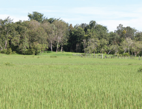
Zone 2 is an agricultural plain, primarily used for rain-fed rice production, with low biological diversity. The level of agricultural intensification and crop diversification in these rice hinterlands are low and the area is mainly managed through household farming. However, a more intensive commercial form of agriculture is practiced where water storage infrastructures are available.
Zone 3 consists of the agricultural and forest area surrounding the archeological park of Angkor Wat. Although family farming is predominant, Zone 3 is under the overall management of APPSARA (Authority for the Protection and Management of Angkor and the region of Siem Reap). The clearing of forest land to expand agricultural land is forbidden by APPSARA, which has created tension with local communities.
Zone 4 is an “agriculture-forest” mosaic area of cropping areas and forest patches. Lack of irrigation water and low soil fertility restrict agricultural productivity in this zone, and the forest is still an important source of subsistence income. Unfortunately, the forest is highly fragmented due to recent deforestation. However, local communities have managed to protect some forest areas under community forestry agreements. Since 2007, the government has recognized 26 community forestry schemes, covering a total land area size of 6,900 ha. Local management groups have started to develop regulations and management plans for these community entitlements and there has been increasing cooperation between local communities, forestry administration, and development partners.
Zone 5 is an upland agricultural area. Water availability and soil fertility problems are similar here to zone 4. Over the last 10 years, forest cover has been entirely cleared and substituted with upland cropping systems, such as rice and other annual and perennial crops.
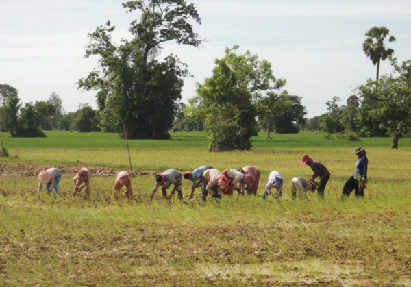
Farmers using new practices to plant rice, COMDEKS Cambodia
Zone 6 is the Phnom Kulen protected area, under the management of the Ministry of the Environment and partly in co-management with local communities in Community Protected Areas (CPAs). People in this zone consider themselves as farmers and they are engaged in a rain-fed agriculture system involving both rice and non-rice (chamcar) production. Timber and non-timber forest resource collection are also central to their livelihoods. Since it is a protected area, land use rules are defined and enforced by the government, limiting forest conversion for agriculture. Within the zone, four specific areas have been designated as CPAs, following co-management principles similar to those used in community forestry schemes. Local management groups have been established and have begun to develop regulations and management plans for these community entitlements. There are 5 CPA schemes recognized by the ministry of environment, covering a total land area of 900 ha. CPAs are considered multifunctional areas that are not restricted exclusively to protection, with the possibility of integrating forest management with other income-generating activities such as agroforestry and tourism.
Socioeconomic Context
The target landscape comprises 10 districts, 66 communes, and 470 villages. The total population is 500,000, with an annual growth rate of 2.2 percent. The heterogeneity of the landscape is an important dimension of the target landscape. Watershed residents are traditionally involved in a wide variety of natural resource management activities across the plain. For example, on the main agricultural land, household farming is dominant (mainly rice, but also other annual and tree crops). Access to land can be a challenge in some zones; in Zone 1, 2, and 3, for example, 40-50 percent of farmers own less than 1 ha of land. In zones 2, 3, and 4, landlessness is a factor among farmers, with 7-28 percent of farmers without land.
Although watershed residents rely upon agriculture for their livelihood, farming is increasingly insufficient to meet employment needs. Farmers opting to use relatively high-yield agricultural practices (including chemical fertilizers and pesticides) may benefit initially, but contribute to land degradation and loss of biodiversity in the long term. Food security in the region has been put at risk as a result.
On public lands, natural resource management is mostly conducted through co-management schemes between communities and relevant government authorities. Management schemes include community forestry on forest land, community-run fisheries on fishing grounds, and community protected areas in the Phnom Kulen Natural Park protected area.
The province of Siem Reap is home to the world-famous historic temple of Angkor Wat, and its surrounding archeological park. The archeological site attracts the largest number of the country’s international tourists. Domestic tourism to the area is also growing. Despite this growing tourist industry, Siem Reap province has one of the highest poverty rates in Cambodia. Although many people in the area around Siem Reap town benefit from the economic impact of the rapid growth in tourism, those employed in the construction, services, and handicraft sectors capture more of these benefits than the 80 percent of families involved in the agricultural sector.
This disparity has contributed to demographic shifts in the area to take advantage of wage employment in the tourism sector. In areas further from the city, individual household members are migrating to the city to work in the construction and services sectors. In areas closer to the city, some entire households are abandoning farming by selling land and moving into non-farm jobs. Thus, there seems to be a gradual shift in the structure of employment and the ownership of land around Siem Reap away from small-scale farming toward tourism and other emerging industries.
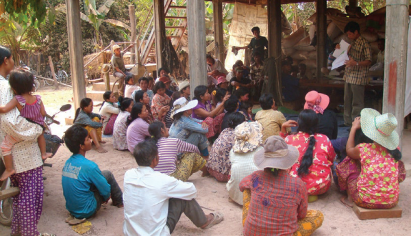
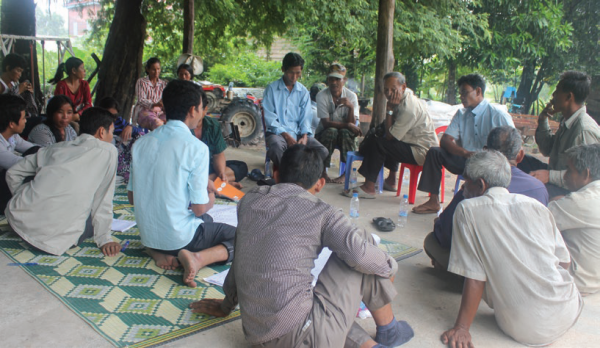
Awareness raising meeting on natural resource management, COMDEKS Cambodia
Key Environmental and Social Challenges
Although key environmental issues vary somewhat by zone, in general, unsustainable farming and fishing practices, illegal logging and forest conversion to agriculture are the area’s most pressing environmental problems.
On the watershed’s agricultural lands, the reliance on intensive modern agricultural practices for subsistence leads to low soil fertility, and subsequently low crop yields. Key issues are limited rainfall, lack of water storage capacity, and low water retention in the soil. In addition, agricultural diversification is limited. Despite a very high demand for vegetables from the growing tourist trade, most vegetables consumed in local restaurants are imported from neighboring countries. The poor coordination between markets and production is paradoxically a key issue in this region.
In the area around Tonle Sap (zone 1), the most important problem faced by the local population is the decline of the fish catch. This is a human as well as an ecological issue attributed to the increased use of illegal or inappropriate fishing gear coupled with the growing number of fishers, the destruction of flooded forests (which are an important spawning ground for the fish), and the use of fertilizers, which pollute water run-off. Although community fisheries have managed to reduce the prevalence of illegal fishing activities, the problems still persists.
Poverty remains a widespread concern due to seasonal unemployment in agricultural production, and the frequency of landlessness amongst farmers. Access to school and health facilities is problematic as well. Illegal logging is common, to increase agricultural plot holdings. Zone 4 (agro-forest mosaic) in particular is highly fragmented due to recent deforestation. Forest cover has been entirely cleared and substituted for upland cropping systems over the past 10 years in zone 5 (upland agriculture).
COMDEKS Activities, Achievements, and Impacts
Community Consultation and Baseline Assessment
The target landscape was chosen both because it was one of Cambodia’s noted biodiversity hotspots, and because it aligned with a region identified by the government, the Mekong River Commission, and GTZ in 2004 for a pilot program in watershed management to address problems of deforestation and resource degradation.
An assessment of problems and potential opportunities in the target landscape was carried out in the field using several different methods. Participatory rural appraisals were organized in 13 villages (two/three villages in each socio-ecological zone), with follow-up workshops in each village to validate the village survey and collect additional information. In total, 66 people participated in these workshops, with participants from community-based organizations, farmers associations, and local authorities. At the village workshops, a number of participatory tools were employed, such as resource mapping exercises to identify community assets, seasonal calendars to clarify the relation between production activities and other natural and economic events, and problem/solution analyses to probe particular issues in each community.
A prime activity at each workshop was the scoring of a set of resilience indicators developed by Bioversity International and the United Nations University. These indicators helped measure and understand the resilience of the different socio-ecological zones of the landscape, with data sets compiled for each separate zone. Finally, a workshop took place in the city of Siem Reap to present the findings of all analyses and indicator scoring and generate discussion with other stakeholders (local authorities and technical institutions) about strengths, weaknesses, opportunities, and challenges of resource management in each socio-ecological zone. The data sets were complemented with secondary information available through local government (commune-level) statistical databases.
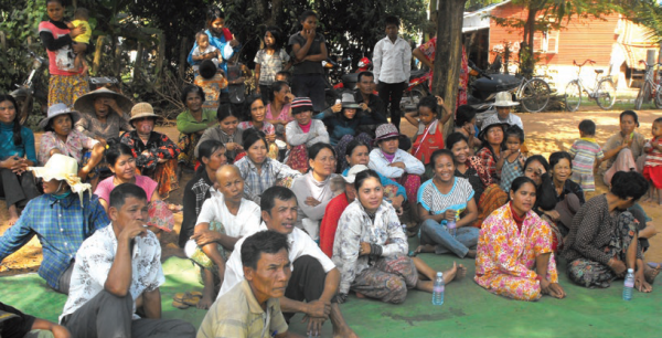
Participatory village mapping, COMDEKS Cambodia
Landscape Strategy
Using the landscape assessment as a basis, stakeholders developed the COMDEKS Country Programme Landscape Strategy for Cambodia, a document that describes and details the different zones in the landscape, sets out a vision for restoring and sustainably managing this diverse landscape, outlines the expected outcomes and indicators, and lists appropriate community-based activities to achieve these outcomes.
- The Steung Siem Reap Landscape Strategy vision: “To maintain and restore functional socio-ecological production landscapes to preserve biodiversity, improve local livelihoods, and enhance ecological and institutional landscape connectivity.”
Table C-1 shows the four Landscape Outcomes around which the strategy is built, as well as the performance indicators that will be used to measure these outcomes. The Strategy calls for addressing problems in upstream areas first to reduce negative impacts downstream. This means initially prioritizing interventions in zones 4, 5, and 6 where forest degradation and biodiversity loss have occurred, and then moving to zones 1, 2, and 3 in the second phase of the program.
Table C-1. Landscape Outcomes and Indicators from the Cambodia Landscape Strategy
| Landscape Outcomes | Key Performance Indicators |
| Outcome 1:
Degraded biodiversity and ecosystem services are restored through multi-functional land use systems. |
· Number of hectares or percentage of land area managed under sustainable multifunctional land use systems.
|
| Outcome 2:
Ecologically sound agricultural production systems in the target landscape are strengthened for a sustainable increase in crop yield and productivity. |
· Number of hectares or percentage of agricultural land put into sound ecological production systems.
· Percentage increase in yield of major crops due to project activities. · |
| Outcome 3:
Livelihoods of people in the landscape are improved through the development of ecologically sound and community-owned income-generating activities. |
· Number of new income-generating activities/measures being implemented that are biologically and culturally practical.
· Percentage increase in income from project activities.
|
| Outcome 4:
Robust governance systems are established and strengthened for effective participatory decision making at the landscape level. |
· Number of community-based organizations established and strengthened with a mandate for conservation and development in the target landscape.
· Number of development plans adopted that integrate landscape management perspectives. |
For each Resilience Outcome above, the Landscape Strategy provides the following guidance on the appropriate focus for local activities:
Outcome 1: focus on protecting natural resources within each zone, while increasing ecosystem services through:
- Reforestation and tree nursery development in areas under community forestry (zone 6);
- Promoting of multipurpose trees and plantations on private forest lands (zones 4, 5, 6);
- Supporting the integration of community forestry and grazing areas into Commune Land Use Plans (zones 4, 5);
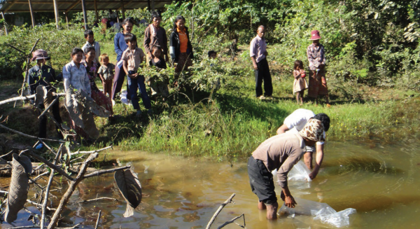
Releasing fish behind the Ta Lean dam, COMDEKS Cambodia
- Developing forest corridors to connect community forestry areas (Zone 4);
- Supporting management of flooded forests and shrub lands, and integrating these into Commune Land Use Plans (zones 1, 2);
- Stabilizing river banks by planting trees (Zone 1-6);
Outcome 2: focus on reinforcing eco-friendly farming and cropping methods to increase soil and crop productivity and enhance livestock production through:
- Promoting the production and use of compost, forest humus, and liquid slurry (Zone 2, 3, 4);
- Use of green manure/cover crops (Zone 4, 5);
- Promoting a system for rice intensification, entailing a change in transplantation techniques, combined with better weed and water control (Zone 3, 4, 5);
- Promotion of hedge rows with fast growing and nitrogen-fixing trees (Zone 2, 3, 4);
- Producing rain water storage systems (Zone 5, 6);
- Introducing bio-digesters (Zone 4, 5, 6);
Outcome 3: focus on addressing lack of farmer-to-market linkages, while enhancing income opportunities for local people through:
- Promoting bee keeping activities and strengthening existing bee keeping associations (Zone 4, 5, 6);
- Promoting ecotourism activities and supporting the improved production of handicrafts (Zone 1, 3, 4, 5, 6);
- Promoting farmer associations (Zone 2, 3);
Outcome 4: focus on ensuring efficient coordination of community conservation activities through:
- Reinforcing community forestry (CF) organizations, community fisheries (CFi) organizations, and community protected area (CPA) organizations, and strengthening their management plans (Zone 1-6);
- Integrating CFis, CFs, and CPAs into commune land use plans and into commune development plans (Zone 1-6), and also, where possible, into district and provincial development plans as well.
- Establishing a network or federation of CFis, CFs, and CPAs (Zone 1-6).
Community-Led Landscape Projects
Based on this guidance, seven local projects were chosen as part of COMDEKS Cambodia’s portfolio of landscape interventions in the Steung Siem Reap watershed (see Table C-2). Each is led by a different community-based organization and supported by a grant of approximately US$38,000 to $50,000.
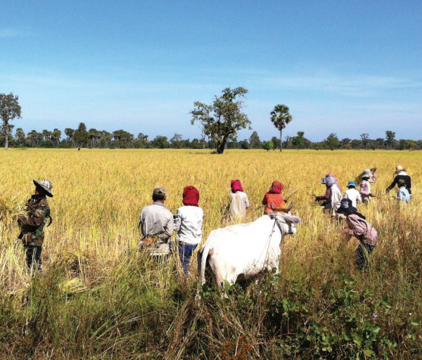
Farmers harvesting rice in Ta Lean dam area, COMDEKS Cambodia
Table C-2. COMDEKS Community-Led Projects in Steung Siem Reap Watershed Areas, Cambodia
| Project | Grantee (LNGO/CBO) | Contribution to Landscape Resilience Outcomes | Description |
| Ecology System Restoration and Community Livelihood Improvement of Steung Siem Reap Watershed | Sataphana Chivit Organization (SCO)
US$50,000
|
Outcomes 1, 2, 3 | Build capacity of communities in the Kok Thlok Leu commune to conserve 10 ha of forest and to manage its 9-ha Community Fisheries Conservation area to increase the natural fish stock. Rehabilitate 2500 m of small canals and 70 m of dams so that farmers have sufficient water to increase crops yields on 500 ha of crop land. Introduce integrated farming systems to 100 farmers. Organize 5 women’s saving groups to increase livelihood options. |
| Promoting Community Forestry Management and Community Livelihood Improvement in Chansor Commune, Soutr Nikum District, Siem Reap Province | Human Resource and Rural Economic Development Organization (HURREDO)
US$47,600
|
Outcomes 1, 3, 4 | Build capacity of three Community Forestry Committees to conserve more than 550 ha of Community Forest Areas by preparing 15-year Community Forestry Management Plans. Demarcate community forestry areas in Chansor Tbong Community Forest and organize community to construct 5,000 m of fire road there. Construct community tree nursery to produce seedlings for forest restoration. Establish agroforestry demonstration sites (pineapple and Chinese Bamboo) and provide training in bee-keeping, as well as developing market connections for these enterprises. |
| Flooded Forest and Fish Refuge Management of Community-Based Eco-Tourism at Kampong Phluk Commune, Prasat Bakong District, Siem Reap Province | Kampong Phluk Community-Based Ecotourism (KPCBET)
US$47,200
|
Outcomes 1, 3, 4 | Improve the economic and ecological resilience of Kampong Phluk Commune by conserving more than 7,900 ha of flooded forest and replanting 15 ha of flooded forest on degraded land. Conserve 13 ha of fish refuge to increase natural fish stock in the target areas. Improve the success of community-based eco-tourism by strengthening the management capacity of community members and providing new tourist infrastructure such as patrol house, dock, and rest rooms to serve the flooded forest and fish refuge. |
| Sustainable Conservation of Watershed and Improving Livelihood of Community Protected Area (CPA) in the Top of Kulen Mountain. | Federation for Integrated Development of Agriculture in Cambodia (FIDAC)
US$49,300 |
Outcomes 1, 2, 4 | Improve the economic and ecological resilience of the community members living on Kulen Mountain by introducing integrated agricultural techniques and developing a sustainable water supply through formation of water user groups, construction of reservoirs and water distribution lines. Protect the ecosystem assets of Kulen mountain by reforesting 25 ha of degraded land, conserving 940 ha of the Kulen National Park, and supporting the formation of 5 Community Protected Areas. |
| Restoration of Ecosystem and Construction of Water System for Livelihood Improvement of Communities in Steung Siem Reap Watershed Areas. | Conservation and Development on Cambodia (CDCam)
US$41,500
|
Outcomes 2, 3, 4 | Increase water availability for human consumption and agriculture in Svay Leu Commune through construction of a community water system. Regulate local water use to increase agricultural production and manage climate change by forming a Water Use Association with appropriate regulations. Raise farm incomes through building the capacity of 50 “model farmers” for integrated agriculture. Diversify local livelihoods by establishing Women’s Saving Groups, and by encouraging the planting, processing, packaging and marketing of Moringa Leaf products. |
| Sustainable Community Forestry Management for Livelihood Improvement of Forest-Depend Community | Rural Economic and Agriculture Development Agency (READA)
US$38,000 |
Outcomes1, 2, 3, 4 | Build the capacity of the SvayChek Community Forestry Committee to conserve its 232-ha community forest by preparing a 15-year Community Forestry Management Plans, demarking the forest with cement poles, reforesting with 30,000 seedlings, and constructing fire roads with labor contributed by community members. Expand livelihoods and income by introducing multi-purpose farming, establishing a Farmer Field School, and installing bio-digesters. |
| Conservation of Community Forest and Improve Livelihood Tropaing Pring Community | Rachna Satrei Organization (R.S)
US$41,800 |
Outcomes 1, 3, 4 | Build the capacity of Tropaing Pring Community Forestry Committee to conserve its 409-ha community forest by preparing a 15-year Community Forestry Management Plan, replanting 50 ha of degraded forest, establishing a community nursery to produce tree seedlings, and constructing fire roads and patrol houses. Establish village saving groups to create revolving fund to invest in small livestock (goats). |
“Protection and conservation of Steung Siem Reap watershed involves everybody—up-stream and downstream; we need to work together to get the watershed back to normal functioning.”
–village workshop participant
Savings group monthly meeting, COMDEKS Cambodia
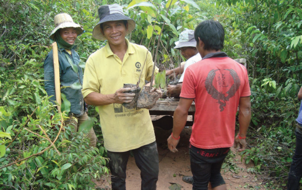
Selecting small trees in community nursery, COMDEKS Cambodia
Achievements and Impacts to Date
- Rehabilitating upland and lowland (flooded) forests: Communities have planted more than 68,000 tree seedlings in degraded community forestry areas and community conservation areas in upland zones, as well as in the flooded forests in community fishery areas in lowland zones. This has improved the condition and management of 7,800 ha of degraded forests.
- Establishing tree nurseries for forest augmentation and agroforestry: Two tree nurseries have been constructed that have produced more than 2,000 seedlings to date. These seedlings include fruit trees for planting in degraded community forestry areas as well as around residences to increase subsistence food supplies and income.
- Establishing management plans for community forests, community protected areas, and community fisheries: Local residents are in the process of developing 15-year management plans for 6 community forests, 5 community protected areas, and 2 community fisheries. These plans will strengthen the sustainable use of some 46,000 ha of forest areas and 5,800 ha of flooded forests within the watershed.
- Enhancing fire protection and forest patrols: More than 13 km of fire roads have been constructed to protect the trees in local community forestry areas. Additional funds have been provided to community forestry committees to support forest patrols.
- Promoting sustainable rice farming. Some 600 ha of agricultural lands have been placed under a more sustainable production system, which has increased the rice yield from 2 tons/ha before the project to 3 tons/ha now.
Tourists visiting Kampong Phluk floating community in Siem Reap province., COMDEKS Cambodia
- Introducing alternative income opportunities: Several projects have introduced new income-generating activities to more than 6,700 local residents, including the culture of bamboo and pineapple crops, integrated farming including crops and animal culture, bee-keeping, and ecotourism. Incomes of those participating in these enterprises are estimated to have increased 15-20 percent over their previous earnings.
- Supporting local organizations and improving environmental governance: Since the implementation of local projects began, some 52 community-based organizations have been established or strengthened to participate in sustainable agriculture and livelihood activities. This includes 13 saving groups, 14 self-help groups, 6 water user groups, 5 rice banks, and one cow bank. In addition, a major focus of the project work is strengthening the capacity of the 11 community forestry organizations, 2 community fisheries organizations, and the 5 community protected area organizations that are responsible for management decisions in these community assets. These groups are working closely with local NGOs, and with different levels of government, such as Commune Councils, the Forestry and Fisheries Administration, the Kulen National Part Authority, the Agriculture Department, and the Department of Rural Development to strengthen their technical and governance abilities.
Progress at the Landscape Level
Although the landscape varies widely in the different zones of the target area, land use problems follow similar themes, including poor management of community forest areas and community fishery areas, lack of sustainable water supplies, and low agricultural yields. The local project portfolio thus emphasizes steps to regularize and improve community resource management and enforcement and rehabilitate degraded areas, as well as up-grade agricultural practices and improve water management. The similarity of these interventions provides a basis for exchanging experiences between communities. However, the complexity of the human and agro-ecological diversity in the landscape complicates the emergence of a larger landscape community and of landscape-level effects. To encourage landscape-wide thinking and interaction among different projects and communities, all GEF-Small Grants Programme grantees in the area, including COMDEKS grantees, attend an annual workshop in which they can share experiences and lessons learned. In addition, all of the COMDEKS projects in the Siem Reap watershed are linked into a pilot watershed management program established in 2004 under the auspices of the Cambodian National Working Group on Watershed Management, supported by the Mekong River Commission and GTZ. The members of the watershed management committee include all target commune council members, district Governors and staff from different technical departments. The COMDEKS grantees work closely with this committee to receive technical support. This committee is responsible for coordinating the implementation of any development activities within the watershed area, as well as donor support for these activities.
Lessons Learned
- Involving local government (Commune Council) in the COMDEKS process has been very beneficial and has increased local skills in designing and implementing projects. For example, Commune Council members are now able to coordinate the support from different technical departments during project design and implementation.
- When community priorities are clearly understood and rapidly translated into actions, local authorities and communities are very willing to participate in project activities. This close link between local voice and action is essential for project sustainability as well. If the local authority and the community have a high level of ownership of projects and see themselves as project managers, they will remain engaged.
- Although the timeline for project implementation in the Steung Siem Reap watershed is typical of SGP projects (1-2 years), it may not be sufficient to accommodate the limited ability of local NGOs and CBOs at the start of the COMDEKS process to plan and execute projects. Building up this local implementation capacity requires time and ample mentoring from support partners and support groups. Ensuring the sustainability and strengthened capacity of local communities, and in particular the Farmer Water User Groups and Saving Groups Committees, an expanded timeline for project support may be required.

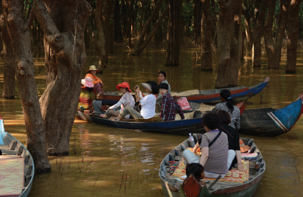
Ms. Chum Kreun taking tourists on a boat tour in the flooded forest in Kampong Phluk floating community, COMDEKS Cambodia