China: Agricultural and Pastoral Landscapes in the Mountainous Districts of the Upper Watershed of the Yangtze River

06.03.2012

  • SUBMITTED ORGANISATION :

  • United Nations University Institute for the Advanced Study of Sustainability (UNU-IAS); Japan Wildlife Research Center (JWRC)

  • DATE OF SUBMISSION :

  • 06/03/2012

  • REGION :

  • Eastern Asia

  • COUNTRY :

  • China (Sichuan Province)

  • SUMMARY :

  • This study was commissioned to be included in the publication “Socio-ecological Production Landscapes in Asia”. This chapter provides an overview of SEPLS practices in the highlands of Sichuan Province as an example of landscape-management practices in the region.

  • KEYWORD :

  • Pastoralism, Yi people, agriculture

  • AUTHOR:

  • Japan Wildlife Research Center (JWRC); Kaoru Ichikawa (UNU-IAS), ed.

  • LINK:

  • http://collections.unu.edu/eserv/UNU:5448/SEPL_in_Asia_report_2nd_Printing.web.pdf

Summary Sheet

The summary sheet for this case study is available here.

Natural and Social Background

[Note: this case study originally appeared in the publication Socio-ecological Production Landscapes in Asia.]

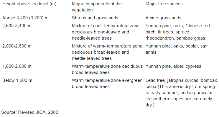
Anning River, a tributary of Yangtze River, runs through the central part of the Liangshan Yi Autonomous Prefecture in Sichuan Province from north to south, and its valley is surrounded by steep mountains. Xichang, the capital of the prefecture, is located about 360 km southwest of Chengdu, and its altitude is a little less than 1,600 m above sea level. The city has an average annual temperature of 17.0°C, and there is a clear distinction between the rainy and dry seasons with 92% of the city’s average annual precipitation of 1,033 mm concentrated in the rainy season from May to October. According to Köppen’s climatic classification, the prefecture has a steppe climate. The climate in the valley of the Anning is characterized by its remarkable vertical variation due to the substantial difference in altitude. The altitude of Miyi County, located downstream from Xichang, is at the 1,100 meter level, and its climate is close to sub-tropical with an average annual temperature of around 20°C. In this county, it becomes considerably dry not only in the dry season, but also in the period up to early summer as is typified by the fact that the amount of evaporation exceeds the precipitation. In contrast, the mountainous district, which is above 3,000 m, has a cool-temperature climate with an average temperature at less than 8°C. These changes in temperature due to altitude can be observed in the vertical distribution of the vegetation (see Table 1). The timberline runs at a height of around 3,400 m above sea level, and declines to 3,200 m in areas where the wind is strong. The vegetation consists of prostrate Yunnan pines (Pinus yunnanensis), oaks (Quercus monimotricha), which grows as a shrub, and bamboo grass (Fargesia pauciflora). In the cool temperature zone, where the altitude ranges from 2,600 m to 3,400 m, it comprises a mixture of needleleaved trees such as fir trees (Abies spp.) and spruce (Picea spp.) and broad-leaved ones such as Chinese red birch (Betula albo-sinensis) and Rhododendron spp. At heights of 2,600 m or lower, it is composed of trees of the warm-temperature zone with the 2,000-2,600 m zone dominated by a mixture of deciduous broad-leaved and needle-leaved trees, the 1,600-2,000 m zone by deciduous broad-leaved trees, and the zone below 1,600 m by evergreen broad-leaved trees (JICA, 2002). Particularly on the southern slopes lower than 1,600 m, trees cannot grow properly because it is too dry. Mammals that live in this area include wild boars, sambars, Chinese pangolins, and jungle cats. In addition, the highlands in Liangshan Prefecture are home to pandas and lesser pandas, both of which are designated as endangered species (Category IB).

Table 1. Major Components of the Vegetation and Tree Species in Liangshan Prefecture by Altitude

In 2010, Liangshan Prefecture, which occupies an area of 60,000 km2, had a population of 4.78 million (population density: 79 persons/km2). Originally, the Yi were dominant in this region, but the number of Chinese who have migrated to this region since the 1950s has continued to increase. Ethnically, they account for the majority of the population at 54%, with the remaining 43% accounted for by Yi, 1% by Tibetans, and 2% by other minorities. Historically, since the Three Kingdoms period in the third century, the Yi have come to live in mountainous districts and on highlands due to the pressure of the Chinese from the lowlands. Liangshan Prefecture can be divided into two major spheres of life with Xichang City forming their boundary. While the lowlands and flatland in the valley of the Anning are inhabited by Chinese farmers, the mountainous districts and highlands, which are located in the upstream reaches of the river and are largely 2,000 m above sea level, are populated by the Yi. The population density of villages 2,000-2,700 m above sea level is 43 persons/km2, and that of villages at 2,700 m above sea level or higher is 26 persons/km2. Villages exist at altitudes of up to 3,500 m above sea level.

From the 1950s to 1980s, the Chinese government took the initiative in promoting forest development. It considered the logging and development of national forests as one of the financial resources for building China as a new socialist country and developed natural forests on an extensive scale (Yorimitsu, 2003). As a result, forests in the upstream and middle reaches of the Yangtze and the Huang were destroyed, causing flood disasters in the downstream regions. A disastrous flood in 1998 led the government to adopt a policy of prohibiting the logging of natural forests in the same year, marking a major shift in its forest policy. Today, afforestation is being promoted through government policies in various parts of the country. Government policies include the “Returning Farmland to Forests” policy, which aims to turn cultivated land into forest land as a measure to prevent agricultural land from being developed by farmers on steep slopes, and the “Closing Hills for Afforestation” policy, which aims to control pasturage and develop the forests.

Agricultural and grazing system in the high-elevation zones

The Yi have developed an agricultural and grazing system that combines grazing and cold-hardy crops suitable for highelevation zones and have maintained agricultural and grazing landscapes even in steep mountains while preventing landslides. Yi agricultural and grazing landscapes, which combine cold-hardy crops and pasturage, are scattered in various places on land above 2,000 m with an area of approximately 40,000 km2 (Photo 1). The following descriptions are based on the results of a socioeconomic survey conducted mainly in the valley of the Anning in 2001 (see Table 2). According to the statistics of municipal governments in five administrative units (Xichang City as well as Zhaojue, Xide, Dechang, and Miyi Counties) covered by the survey, 13% of the land (86,000 ha) in ten villages in these administrative units was used for agricultural land, 30% for grasslands, and 44% for forests, and 13% was accounted for by wasteland and land used for other purposes.

Photo 1. Zone at 2,000-2,700 m above sea level – Harvesting on Cultivated Land in Zhaojue Country (Photo: Japan Wildlife Reserch Center)

Table 2. Amount and Percentage of Average Cash Income by Altitude and Industry (Units: households, yuan, and %)

Source: Revised JICA (2002)
Note: In this survey, interviews were conducted covering a total of 1,000 households (100 per village) in ten villages in five counties around Xichang City. Three Yi villages were located in each of the 2,000-2,700 m zone and the zone above 2,700 m, and villages consisting mostly of Chinese were located in the zone below 2,000 m. The table indicates the figures for villages in each elevation zone.

The grazing of sheep and cattle is suitable for cool mountainous districts with vast stretches of grassland. The Yi have a stable diet of crops that are cold resistant and resistant to unseasonable weather, examples of which include buckwheat, particularly a slightly bitter buckwheat, potatoes, and oats. The particularly important food crop is the potato (Matsushima, 2004; see Table 3). After the potatoes are harvested, turnips and grass are grown as an off-season crop, which is used as feed for sheep and other types of livestock, and this means that fields important as a means of food production are used for the cultivation of livestock feed for a certain period of the year. The Yi combine these crops with stock farming centered on sheep and pigs. Yi families living at 2,000 m or higher in the survey area raise two to three cattle, five pigs, 13-20 sheep, and 15 chickens on average and sell a little less than one head of cattle, three to five pigs, four to six sheep, and ten to 13 chickens annually. Domestic animals are an important source of income. In addition, income from forest products such as Japan pepper trees, walnuts, and pine resin has continued to rise in recent years.

Table 3. Ratio of Crops Cultivated and the Average Number of Domestic Animals Owned and Sold by Altitude and Crop (Units: households, %, and heads)

Source: Revised JICA, 2002

Feed for sheep includes grass as well as Pinus yunnanensis, the leaves of shrubs, and bamboo grass. That for pigs consists of boiled agricultural products such as potatoes, corn, bitter buckwheat, oats, and turnips. The pigs are fed with boiled food once in the morning and then released into the mountains and fields. Pigs kept by the Yi also catch crabs in mountain streams and eat insects and wild herbs. They are highly rated for their firm body. Even if they are released, the pigs return to their keeper’s house for the boiled food, but the grazing of sheep requires shepherd boys. As the Chinese economy grew, the price of pork has recently soared, prompting some wealthy Yi farmers to concentrate on raising pigs in their pigpens. These farmers mainly grow such crops as potatoes and turnips in large quantities to secure sufficient feed.

Another traditional technique to maintain the fertility of agricultural land in this cool climate is to leave the cultivated land fallow for some years after production (Photo 2). The Yi cultivate bitter buckwheat, oats, and other crops in their fields only once every two to four years, and by doing so they leave the cultivated land fallow for as long as possible in order to facilitate the recovery of its fertility. Since the cultivated land left fallow is used to graze sheep and cattle, the excrement of these animals is returned to the cultivated land, which is a reasonable way of keeping the land fertile. Moving to high-elevation land for grazing in summer, meanwhile, enables the Yi to avoid using land for both agriculture and stock farming at the same time. As one of the options needed in order to preserve grass resources, this is practiced in Zhaojue and Meigu Counties, particularly among the highland settlements that have a long winter. The Yi collect brushwood, grass, pine needles, and other materials for fuel, and some of them also use straw and other plant stems that are the byproducts of agricultural production.

Challenges and Responses

With the increasing elevation of the land, the demand for fuel materials grows. A comparison of the average annual amount of fuel materials consumed per household indicates that 0.7 tons of brushwood is collected and consumed for firewood in the warm zone below 2,000 m, 3.3 tons in the 2,000-2,700 m zone, and 6.6 tons in the zone above 2,700 m. Brushwood is used for cooking, boiling of food crops for pig feed, and heating. Large amounts of fuel materials such as brushwood are consumed by highland settlements, making the improvement of fuel efficiency an issue yet to be addressed. Efforts are being made to introduce improved kitchen stoves, but the Yi perceive their existing three-stone stoves as a tradition. Improved kitchen stoves also have such problems as being inferior as nighttime lighting or heating systems.

Photo 2. Zone above 2,700 m – Cultivated Land Left Fallow for Grazing in Xide County (Photo: Japan Wildlife Reserch Center)

As mentioned earlier, the Chinese government is pressing forward with its “Returning Farmland to the Forests” policy, which is particularly important to the Yi’s sphere of life in the steep mountainous districts. This policy involves turning the slopes that have been excessively cultivated back into forests in order to accelerate the implementation of afforestation policy. It is producing steady results by providing low-income farmers with food and paid work. At first, planting nursery trees and agricultural crops at the same time was prohibited (Shang and Seki, 2003), but it came to be understood that such planting did not have adverse effects on the growth of nursery trees if it was not unbalanced, and today, the “Returning Farmland to Forests” policy is being promoted by planting nursery trees and agricultural crops at the same time. In the Yi society, meanwhile, the number of elderly persons living in mountainous and outlying places is on the rise, and for these people it is becoming difficult to cultivate land on the steep slopes. For this reason, fruit trees have come to be chosen as tree species that should be planted under this policy. The forestry bureau of Liangshan Prefecture actively recommends the planting of fruit trees, and in particular the planting of walnuts in the cool highlands has been well received. The types of fruits in demand vary according to the regional conditions; while the planting of Japan pepper trees is being promoted in the colder highlands, that of oranges is being encouraged in the much warmer areas.

References

Japan International Cooperation Agency. 2002. Survey for the Afforestation Plan in the Valley of the Anning River in the Chinese Province of Sichuan, p.330.

Matsushima, N. 2004. A study on regional and tribal differences of deforestation in the Anning Watershed of the upper Chang Jiang, China. Bulletin of the Graduate School of Social and Cultural Studies, Kyushu University. 10, p.49-67.

Shang, F. and Seki, Y. 2003. “Returning Farmland to Forests Policy in China and Residents in Povertystricken Areas”. From Destruction to Reconstruction- From Asian Forests. Yorimitsu, R. ed. Nihon Keizai Hyouronsha Ltd., p.149-209.

Yorimitsu, R. 2003. “The Destruction and Reconstruction of Forests in East Asia”. From Destruction to Reconstruction – From Asian Forests. Yorimitsu, R. ed. Nihon Keizai Hyouronsha Ltd., Tokyo, p.1-20