Influencing SEPLS governance policy through action research: an assessment of recreational values to promote sustainable use of the Mabira Central Forest Reserve, Uganda
01.11.2016
-
SUBMITTED ORGANISATION :
-
Nature and Livelihoods
-
DATE OF SUBMISSION :
-
01/11/2016
-
REGION :
-
Eastern Africa
-
COUNTRY :
-
Uganda (Mabira Central Forest Reserve)
-
SUMMARY :
-
Increasing pressures on protected areas in the form of intensification of authorised and unauthorised uses requires that governance policies and management approaches be dynamic within reasonable timesframes to prevent degradation and loss. Recreation is one form of protected area use that has not been much emphasised in Uganda’s forest reserves. Recreational values of the Mabira Central Forest Reserve were assessed with the objective of promoting a policy shift from emphasis on extractive forms of use to non-extractive ones. The assessment was conducted throughout the forest with greater focus on peripheral areas that would be most accessible for recreation. Landform, land use, cultural and biodiversity values were assessed. Here, we show that the forest has attractions of unique appeal that are currently not being used for tourism. We also present a unique dataset for known attractions that should be valuable in use of the forest for tourism. To make newly described attractions available for recreational purposes and reduce ongoing illegal resource overexploitation, we recommend a policy shift that increases the size of the area allotted to recreation. We also describe infrastructure developments needed to operationalise that policy change. A broad lesson from this study is that where conservation landscapes are becoming degraded from given forms of use, it makes sense to lay more emphasis on alternative, more sustainable uses.
-
KEYWORD :
-
Biodiversity; Ecotourism; Forest management; Mabira Forest; Sustainable use; Tourism
-
AUTHOR:
-
William Olupot, Nature and Livelihoods; Gilbert Isabirye-Basuta, Department of Zoology, College of Natural Sciences, Makerere University
Summary Sheet
The summary sheet for this case study is available here.
Introduction
Mabira Central Forest Reserve (hereafter referred to as “Mabira” or “Mabira Forest”) (29,974 ha) was first gazetted in 1932 (Mugumya & Shabomwe 1994). It is situated 54 kilometres east of Kampala city and 26 kilometres west of Jinja town (Forest Department 1996). It is a government forest managed by the National Forestry Authority (NFA). It lies in an area of gently undulating land interrupted by flat-topped hills which are remnants of the ancient African peneplain. This peneplain was uplifted by tectonic movements which lowered the land south of the reserve and resulted in the formation of the present Lake Victoria (Pallister 1957 as cited in Ministry of Water and Environment 2010).
From the viewpoint of importance for biodiversity conservation, Mabira is the only remaining large natural forest in central Uganda, the smaller forests having been severely degraded or lost during the last five to twenty years. Its vegetation is classified as medium altitude moist semi-deciduous and is considered to be of sub-climax stage. Two hundred and two tree species have been recorded in the reserve (Forest Department 1996), five of which are of international conservation concern (BirdLife International 2015). According to forest department reports (Forest Department 1996), the reserve is “above average” for Ugandan forests for butterflies and birds, and “average” for other taxa. Mabira is an Important Bird Area with almost 300 species (BirdLife International 2015). There are several bird species of the Guinea-Congo Forests biome that are not well-represented in other protected areas in Uganda (BirdLife International 2015). The forest is one of the four remaining hold-outs of Uganda’s only endemic/near endemic primate, the Uganda crested mangabey (Lophocebus ugandae); the others being Kibale National Park, Bugoma Forest Reserve, and Sango Bay forests (Olupot 2013).
The reserve has a checkered history of encroachment. Parts of it were illegally settled in 1953 and then again between 1961 and 1971. These were however easily contained through evictions (Mugumya & Shabomwe 1994). Incidents of encroachment increased from 1971 to 1985, during which up to 7,000 hectares of the forest, mainly east of the reserve, were cut down by the encroachers. These settlers were removed by the end of 1989 (Mugumya & Shabomwe 1994, Ministry of Water and Environment 2010). In early 2007, the government proposed to give up approximately 30% of the reserve for sugarcane farming, but this was withdrawn in October the same year (BirdLife International 2008).
The reserve (Figure 1) is managed under a plan that partitions the forest into three zones; the inner zone, which is a “strict nature reserve”, and the outer zones comprised of the “buffer zone” which includes the recreation zone, and the “production zone”. The strict nature reserve covers 23% of the forest and no activities are permitted there except scientific research and law enforcement. Tourism activities are permitted only in the recreational and buffer zones which cover 22% of the reserve. The production zone which covers 54% of the reserve is allocated to sustainable supply of round wood for Uganda’s plywood and veneer industry (Ministry of Water and Environment 2010). Local communities are permitted to collect non-timber forest products such as medicines and firewood for subsistence use from the production and recreational zones. Local people are also permitted access to weaving materials such as the rattan cane and raffia palm for commercial purposes from these zones. From the viewpoint of this publication therefore, the peripheral area comprised of the production, buffer, and recreational zones altogether covering 76% of the reserve can be considered a Socio-ecological Production Landscape (SEPL). Therefore unlike most SEPLs ethat are subject to the jurisdiction of individual land owners, this one is managed by the government.
Local people are permitted to use the forest or access resources within the framework set by the National Forestry and Tree Planting Act of 17 June 2003. According to section 32(1) of the act:
No person shall, except, for forestry purposes and in accordance with a management plan, or in accordance with a license granted under this Act, in a forest reserve or community forest (a) cut, take, work or remove forest produce; (b) clear, use or occupy any land for i) grazing, ii) camping, iii) livestock farming, iv) planting or cultivation of crops, v) erecting of a building or enclosure, or vi) recreational, commercial, residential, industrial or hunting purposes; (c) collect biotic and abiotic specimens; or (d) construct or re-open a road, track, bridge, airstrip, or a landing site (Government of Uganda 2003).
Local people access resources from the forest under section 33(1&2) of the Act, which states:
(1) subject to the management plan, a member of a local community may, in a forest reserve or community forest, cut and take free of any fee or charge, for personal domestic use in reasonable quantities, any dry wood or bamboo; (2) for the avoidance of doubt, no person may, in a strict nature reserve or a site of special scientific interest cut or dry wood or bamboo or other forest produce (Government of Uganda 2003).
The current management plan (Ministry of Water and Environment 2010) further clarifies and details how local communities can access forest resources. In section 2.10.2, it is stated that:
Domestic animals are allowed to visit water and salt licks in the reserve on specific arrangements with NFA, but grazing will require a license. Local communities have specific sites in the forest reserve with special cultural attachments (Ministry of Water and Environment 2010).
In section 2.3, the plan also states that:
Use of rattan cane for hand craft has developed considerably, as has use of leaves of a wild date palm, Phoenix reclinata, for making floor mats. Other non-wood products include wild coffee, clay, sand, stones, herbal medicine, fodder, thatching grass etc. However, NFA has no quantified volume of the products taken out and their value (Ministry of Water and Environment 2010).
These resources are intended for collection under collaborative forest management agreements (CFMs) with local community groups. In reality, enforcement of the forest use principles outlined in the act and management plan is a challenge, and the forest is under pressure from both unauthorised uses and overexploitation under permitted uses.
These pressures arise from several causes. First is the weak law enforcement capacity of NFA. Second is the fast-rising Ugandan population, estimated to be growing on average 3.4% per year, with Mabira situated in one of the most densely populated parts of the country. This may be contributing to an increase in demand for various forest products, which according to the management plan has been increasing in recent years. The most exploited resources include firewood, timber, and non-timber forest products. The demand for rattan cane has been one of the fastest rising of the commercial non-timber forest products, and this forest is now known to be no longer able to supply rattan. Removal of both timber and non-timber forest products occurs irrespective of zoning status. Third, Mabira, being located close to Uganda’s capital city of Kampala, and Jinja (one of the largest towns in the country) and near the rapidly industrialising towns of Mukono, Lugazi, and Njeru, has experienced increasing pressure for resources as forests on private land get depleted. There is therefore a rising demand for forest products to meet the needs of both the population and industry.
Experience from other forests in Uganda, for example the Bwindi Impenetrable National Park, shows that no single approach is sufficient to sustain forest integrity. In this park, each of the six Integrated Conservation and Development strategies (ICDs) that have been employed to promote local community support to sustain park integrity made some contribution to that goal by reducing illegal activities such as timber extraction and agricultural encroachment, reducing incidences of fire outbreaks, and generally improving relations between the park staff and local communities (Blomley et al. 2010). Yet even these may not be enough to achieve the desired state of a protected area as shown by Olupot et al. (2009a).
So far, only three of the six main strategies that have been in Bwindi and other Ugandan parks such as Kibale and Rwenzori Mountains are applied in Mabira. These are: i) law enforcement, ii) community access to forest resources, and iii) tourism. Moreover, their implementation is weak. Law enforcement is thin, community access to resources is largely unregulated, and tourism is poorly developed or promoted. Nature and Livelihoods has been involved in the promotion of tourism in Mabira since 2013 (Olupot 2013) as part of a wider effort to promote sustainable use as a strategy to prevent degradation. The objective of this study was to assess opportunities to expand tourism by recording potential aesthetic and recreational values. This was intended to guide a policy shift towards more sustainable practices and to diversify forest-based livelihoods of the local people.
Methods
Explanation of the meaning of “tourism” as used in this paper
The word “tourism” as used in this paper refers to “ecological tourism”, or “Ecotourism”, as defined by IUCN’s Ecotourism Programme namely:
Environmentally responsible travel and visitation to relatively undisturbed natural areas, in order to enjoy and appreciate nature (and any accompanying cultural features — both past and present) that promotes conservation, has low visitor impact, and provides for beneficially active socio-economic involvement of local populations (Ceballos-Lascuráin 1996).
Survey approach
The survey was conducted from September to October 2015 by a four-man core team comprised of people with substantial knowledge of Ugandan forests (the authors and two others). NFA was involved at all stages of the study, including identification of the project, field implementation, and discussion of the recommendations. In the field NFA was represented by Mr. Michael Ojja, the officer in charge of law enforcement in Mabira. The fourth team member was Mr. Robert Kungujje, a tourism officer / bird expert of Mabira Forest Integrated Community Organisation, MAFICO, and NGO owned by people living around Mabira.
The first step in documenting attractions was to identify locations to visit based on landform features, historical or cultural significance, and biodiversity attractions. Selection of locations was conducted with the help of topographic, drainage, and vegetation maps. Consultations were also made with NFA field officers and local people to ensure that all known but unrecorded attractions, including cultural sites inside and within the immediate environs of the reserve, were visited.
Assessment of attractions
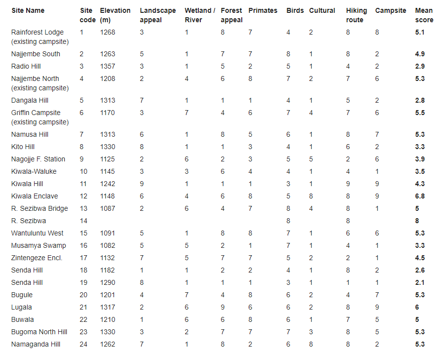
Altogether, 24 locations were visited (Figure 1). Upon arrival at selected locations, the team familiarised itself with the area by observing the condition of the forest, landform features, scenery, and noting primates and birds seen. Locals encountered were also asked about historical and cultural sites in their localities. Each location was evaluated for recreational appeal based on four main criteria:
a) Landform appeal – beauty and/or recreational appeal of natural landform features (e.g. scenic views from hilltops, and scenic views of valleys, rivers and wetlands);
b) Appeal of biological characteristics – occurrence and abundance of species that would normally be sought by tourists visiting a forest environment (e.g. primates and uncommon bird species, appeal of the forest based on the degree of tree maturity, ranging from mature to heavily degraded);
c) Cultural value – (historical and/or present) occurrence of cultural sites (ceremonial, spiritual, historical) and potential appeal for tourist visits; and
d) Aesthetic appeal of surrounding land use practices – types and aesthetic appeal of human developments within visible distance from elevated points (particularly as related to agricultural landscapes and built-up areas).
Each location was rated in the field in a participatory manner for these criteria on a scale of one to ten, whereby one represented the lowest rating and ten the highest. The suitability of each of the locations for campsites or hiking trails was scored on the same scale. Accessibility by motor vehicle was taken into account when scoring for campsite suitability. Ambience as judged from aesthetic appeal, and freedom from noise of human origin were additional criteria taken into account when scoring for campsite suitability. For long distance hiking routes, occurrence of scenic spots and suitability of terrain were additional considerations. The three existing campsite locations were also scored according to the same criteria to facilitate understanding of the recreational value of potential new campsite locations.
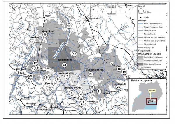
Figure 1. Map of Mabira Central Forest Reserve showing existing management zones and sites visited during the survey (Source: NFA GIS Section)
Rating of sites for campsites and hiking trail routes
The appeal of each site based on criteria was determined by comparing assigned scores, and selection of locations for potential new campsites and trail routes was conducted by examining the averages of assigned scores. Lugala Compartment (Site 21), Kiwala Hill (Site 11), and Namusa Hill (Site 7) were the highest rated for establishment of new campsites. Bugoma North Hill (Site 23), although assigned a low score in the field, was later considered by the team to have high potential for establishment of a camp in the event of high demand. Overall, the Kiwala Hill and Lugala Compartment areas were the highest rated as potential campsite locations, even higher than locations of existing campsites. All the highly rated sites for campsites were also highly rated for routing long distance hiking trails. Other sites rated highly for potential hiking routes were Namaganda Hill (Site 24, for iron smelting history), Kito Hill (Site 8, for illustration of the Buganda peneplain), and Senda Hill (Sites 18 & 19, for illustration of exotic species dominance of a forest following heavy disturbance) (Table 1).
Evaluation of biodiversity characteristics of locations highly rated for new campsites and forest around existing campsites
Detailed assessments of site-specific biodiversity values were conducted only for existing or potential new campsites to confirm the appeal of the latter for facility establishment. Assessment focused on taxa that were considered to be of main tourism interest in tropical forest situations, namely primates, birds, trees, and butterflies. Data were collected along one kilometre transects set within a radius of two kilometres or so of potential and existing campsites. Transects were marked out in 50 metre lengths aligned in north, south, east and west directions to cover landforms and forest types in each area representatively. A measuring tape was used to mark transect centerlines and the lengths of each segment.
Large trees (>50 cm Diameter at Breast Height or DBH) within five metres of either side of the transect centerline were identified and DBH recorded (Figure 2). Butterflies were counted within 2.5 metres of transect centerlines. Primate groups or individuals seen or heard from the transect centerline were identified and recorded. Similarly, birds seen or heard from the transect centerline were identified to species level and recorded. For all taxa, efforts were made to avoid multiple recording of the same individuals within the 50 metre transect lengths. The number of trees with buttresses large enough for use for nesting by birds such as Nahan’s Francolin (Ptilopachus nahani) were counted within five metres of the transect centerlines.
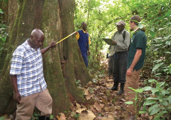
Figure 2. Field team taking and recording DBH of a large tree along the sampling transect. L-R: a volunteer, William Olupot, field assistants, and Gilbert Isabirye-Basuta (Photo by William Olupot)
Data analyses varied by dataset. For birds, analyses were based on totals of the numbers heard and seen. The same approach was used for primates. For all taxa, data were summarised by density. Shannon-Wiener diversity indices (H) and evenness values (H/Hmax) were calculated where appropriate (only trees and birds). Single factor ANOVA tests were conducted to evaluate inter-site differences where relevant. Inter-site comparisons were also made by means of ranks assigned to variables such as density, number of species, species diversity, and evenness. Shannon-Wiener diversity indices were calculated using the following formula:
whereby H = diversity index, pi = the proportion of species i relative to the total number of species in each site, and lnpi = the natural logarithm of this proportion.
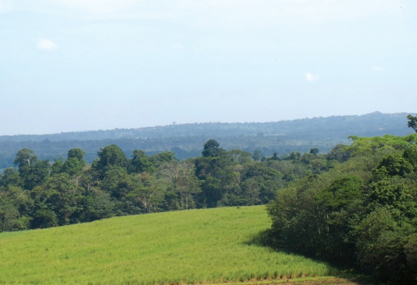
Figure 3. Part of the landscape view from Kiwala Hill, Site 11 (Photo by William Olupot)
Results
New attractions documented
The following new attractions that are not currently being used for tourism in Mabira were recorded: i) rare primary forest easily accessed from major roads (Sites 15 & 21), ii) location with a rare landscape view combining both forest and scenic agricultural landscape (Site 11, Figure 3), iii) slopes with a gentle climb offering an opportunity for fitness hiking (walks, jogging, biking) (Sites 7, 23 & 24), iv) sites with cultural history as iron smelting or ore collection sites (Sites 24 & 11 respectively), v) a location with potential to experience the forest and two types of commercial agriculture (tea and sugarcane plantations) (Site 11), vi) a location with a high likelihood of seeing the endangered Nahan’s Francolin (Site 21), vii) a potentially unique birding location offering an opportunity to view forest, riverine, and savanna wetland birds in one hike (Sites 10-14), viii) a potential river boating route (Sites 13 & 14), ix) suitable locations to showcase the peneplain that existed in East Africa before tectonics leading to the formation of Lake Victoria and the surrounding landscape (Sites 7 & 8), and x) a location with potential to experience the impact of past disturbances in Mabira demonstrated by proliferation of the tree Brousonettia papyrifera (Site 19).
Comparison of overall recreational values between locations of existing campsites and sites highly rated for establishment of new campsites
Sites 11 and 21 were rated higher for campsites than locations of existing campsites. Differences in overall ratings for potential new campsites (Sites 7, 11, 21 and 23) and existing sites (Sites 1, 4 and 6) were however not statistically significant (Single Factor ANOVA, p=0.82, df=6).
Comparison of biodiversity characteristics between locations of existing campsites and locations highly rated for new campsites
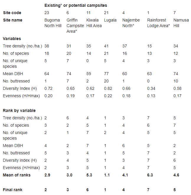
Assessments of biodiversity values of existing campsites (Griffin, Site 6; Ecotourism Center, Site 4; Rainforest Lodge, Site 1); and potential locations for new camps (Lugala Compartment, Site 21; Kiwala Area, Site 11; Namusa Hill, Site 7; and Bugoma North Hill, Site 23) revealed similarities but also interesting differences presented below by taxon.
Table 1. Site identity and recreational scores by criteria. Mean scores are of criteria other than appropriateness for hiking routes and campsites. Landform appeal criteria consist of landscape appeal and wetland/river features; appeal of biological characteristics criteria includes forest appeal and presence and abundance of primates and birds; and cultural value criteria relate to cultural features. The scoring of aesthetic appeal of surrounding land use practices as a criterion is not included in this table but was zero or negligible for all sites except Kiwala Hill which was considered to score at the level of 8 or higher.
Trees
A total of 52 tree species were recorded in the seven sites. Excluding six that were not identified, these represented approximately 25% of the total number known for Mabira. The average density of the trees was 33 ha-1 and there was pronounced variation in density between sites (ANOVA, p=0.049). The most commonly recorded species was Celtis mildbraedii (31 individuals), followed by Antiaris toxicaria (20), and Trilepisium madagascariense and Maesopsis eminii with 14 individuals each. Rankings of sites by tree density, mean DBH, number of species, number of unique species, species diversity, and evenness consistently showed Lugala West as the superior site for these variables, taking a number two position only in the number of unique species (in this case referring to species recorded in only one site) recorded. It was followed by Bugoma North, Griffin, Najjembe North (Ecotourism Centre), Namusa Hill, Kiwala area which includes Kiwala Hill and neighboring forest compartments, and the Rainforest Lodge area (Table 2).
Table 2. Ranking of sites by tree variables. Ranks are considered only preliminary as the dataset is considered small. The word “Area” refers to forest surrounding existing or potential campsites.
Birds
Lorem ipsum dolor sit amet, consectetur adipiscing elit. Ut elit tellus, luctus nec ullamcorper mattis, pulvinar dapibus leo.
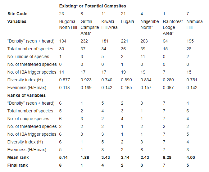
A total of 73 bird species were recorded in the seven sites amounting to 24% of the approximately 300 species known for Mabira. Of these, 32 were among the 75 listed as IBA trigger species (BirdLife International 2015). Nahan’s Francolin (Ptilopachus nahani), the only endangered bird species occurring in Mabira, was recorded only in the Lugala site. Sites differed noticeably in number of species and in other variables analysed for birds; the obvious difference (ANOVA; P < 0.0001) occurring in numbers recorded per site. Griffin was found to be the number one site, overall followed by Lugala West, Najjembe North (ecotourism site), Kiwala, Namusa, Bugoma North, and Najjembe South (Rainforest Lodge), in that order. None of the species that were recorded along River Ssezibwa during the site scoring exercise were recorded in the transects. If included, the Kiwala Hill area would by far have been the superior site, at least in the number of species a visitor can potentially encounter there (Table 3).
Table 3. Ranking of sites by analyses of bird records. Ranks are only preliminary as the dataset is limited. The word “Area” refers to forest surrounding existing or potential campsites.
Butterflies
Counts of butterflies also showed major differences across sites (ANOVA; P<0.0001) with the largest number counted in Namusa Hill followed by Najjembe South (Rainforest Lodge area), Kiwala, Bugoma North, Griffin, Lugala, and Najjembe North (Ecotourism Centre), in that order (Table 4).
Table 4. Ranking of sites by the number of butterflies counted. Ranks based on butterflies are highly uncertain due to the limited nature of the dataset. Butterfly activity can be highly variable and accurate ranking depends on obtaining a representative sample that controls time of day, weather and season. The word “Area” refers to forest surrounding existing or potential campsites.

Primates
Although local people report that the tantalus/vervet monkey (Chlorocebus tantalus) occurs in Mabira, only two species were encountered during this survey: the Uganda crested mangabey Lophocebus ugandae (Figure 4) and the Redtail monkey Cercopithecus ascanius (Table 5).
Table 5. Primates occurred in each site. Ranking is not possible without reliable data on densities. Nevertheless, is the results are significant as this represents the first systematic assessment involving large to medium-sized mammals in the reserve. The word “Area” refers to forest surrounding existing or potential campsites.
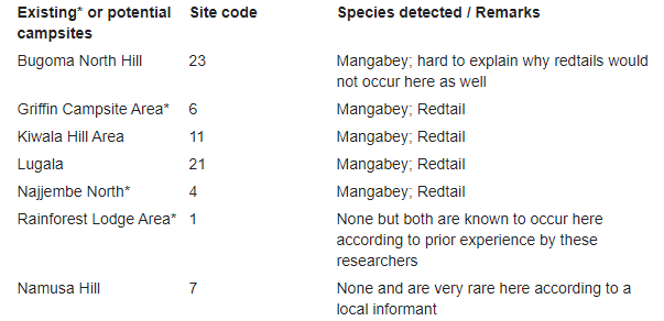
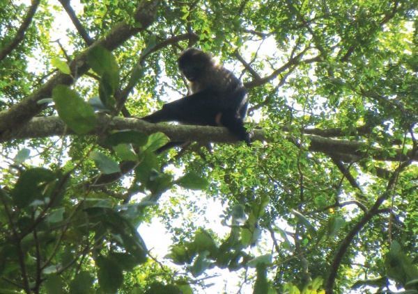
Figure 4. Picture of the Uganda Grey Cheeked Mangabey taken at Site 12. (Photo by William Olupot)
Discussion
Results show that the Mabira Central Forest Reserve has more attractions than are currently recognized. If fully utilised, these attractions can contribute to alternative livelihoods for the local people while reducing pressure from illegal use of the forest (Figure 5). Local communities could benefit from tourism jobs and an expanded market for local produce. Illegal resource extraction would likely be deterred by the increased presence of people using the forest non-extractively.
The anthropogenic pressure to which Mabira is subjected is not unique as such pressures have been documented in comparatively well-protected forests and result in measurable effects on flora (e.g. Olupot et al. 2009a, Olupot et al. 2009b). But the pressures here require more attention than they are currently receiving. They are both species-specific and generalized.
These pressures have occurred over approximately a century, increases coinciding with periods of political instability and / or weak enforcement (Mugumya & Shabomwe 1994). During this study, it became apparent that species like the rattan cane (Calamus deeratus), the raffia palm (Raphia farinifera), the forest understory shrub Acalypha neptunica, and the wild rubber tree Funtumia africana, are harvested to a point in which supply is no longer possible from at least some locations. . The urgency of the need to address conservation issues of this forest is reinforced by the fact that many natural forests in Central Uganda have recently been lost to exotic trees such as Pinus and Eucalyptus species, and to small holder farming. Nature and Livelihoods is implementing activities to to relieve pressures on the forest by for by promoting alternative livelihoods, forest restoration, and recreational use. However, efforts like these in themselves would not be sufficient to curtail unauthorised forest use Law enforcement needs to be strengthened and a wide range of alternative forms of use need to employed.
By advocating for greater use of tourism, we do not argue against uses currently authorised by NFA, such as subsistence use of non-timber forest products by local communities. We however argue that illegal and over extraction of resources needs to be curtailed. Our interactions with local communities during this study suggest that there is consensus on this issue. In addition to tourism promotion and enhanced law enforcement, this issue can also be addressed by empowering community-managed collection of forest products through training in use of appropriate tools, such as community-based monitoring and engagement in resource restoration.
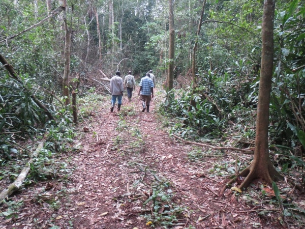
Figure 5. Illustration of unsustainable use ongoing in the reserve. Picture illustrates an illegally established track used to ferry out illegally cut timber at Site 21. In the centre of the picture, the researchers inspect the track. (Photo by William Olupot)
To promote sustainable use through tourism, new campsites need to be established to make use of the identified recreational and educational values.
Results from the “campsite-level” assessment of biodiversity also point towards the exceptional potential of the areas around Site 11 and in and around Site 21. If confirmed through a more detailed survey, inter-site similarities are an indication of what a visitor might expect to experience irrespective of the site they visit. The differences illustrate what could be unique to each location that visitors might want to experience.
This study has provided information that can promote sustainable use of the reserve through better use of recreational values. Information provided can also contribute towards development of a tourism strategy for the reserve by providing some of the information needed to answer the following questions: How could tourism management be improved? How could tourists’ experiences be enhanced? What opportunities are being missed? What would the reserve management like to communicate to the visitor? (IUCN, n.d.) By advocating for strengthening of tourism activities as an approach to promote sustainable use of the reserve, the SEPLS (Socio-Ecological Production Landscapes and Seascapes) concept mainstreamed into sound landscape use would include: resource use within the capacity of the environment, promotion of cyclic use of natural resources, multi-stakeholder participation and collaboration, contributions to sustainable socio-economics, and ensured recognition of local traditions and culture (Satoyama Initiative 2010).
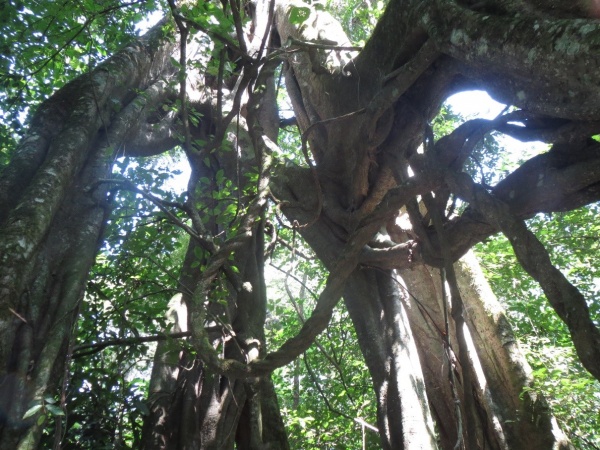
Figure 6. Large strangler fig with the supporting tree long dead and decomposed. Trees such as this are used by the locals as sites for healing. Picture taken from Site 12. (Photo by William Olupot)
Conclusions and recommendations
Results from these assessments, though limited in analysis of biodiversity values, are sufficient for guiding policy at the protected area level. From a global perspective, they serve to illustrate that in some cases, recreational values of a given landscape are not usually fully understood. Where conditions permitfor a given landscape, assessments may need to understand tourism values to a full extent so that they may be used to promote sustainable use. For purposes of day-to-day management of tourism in Mabira, more detailed information is needed on biodiversity and cultural values (e.g. Figure 6), particularly from campsite locations so that visitors can know the specifics of what to expect to find where. Such information would also be needed for future monitoring of impact of this form of use.
Based on results from this study, we recommend the following changes bearing on policy and decision making on recreational use of for Mabira:
- Widen the recreational zone to include compartments to the west lining the Nagojje-Ntunda Road and those to the south abutting the Kampala-Jinja Road in the area of Site 21. We do not imply that changes in existing CFM agreements or other legal access of these areas by local communities should occur. However, the policy of managing those areas for round wood production needs to be reviewed.
- Set-up new tourism camps as soon as possible at Sites 11 & 21.
- Set up at least two new long distance hiking trails; one running from Site 11 to 13, then along the Sezibwa river from Site 13 to 14, then a road trail to Site 15. Another road trail should run from Site 15 to 11, and another should connect Sites 7, 24, & 17.
- Manage hunting to ensure that at threatened species and those of tourism interest are better protected. Currently, we are not aware of any hunting threatening these categories but from knowing that hunting is rcommon in this forest, we know that it could pose risk to such species in future.
- Further assess the recreational values of Rivers Sezibwa and Musamya.
- Record the cultural history of Namaganda Hill and Kiwala Hill Area, traditional beliefs and practices associated with River Sezibwa, and to identify additional sites of major cultural significance.
- Conduct an assessment of medium to large mammals in the reserve to inform forest management. The current status of Nahan’s partridge, Ptilopachus nahani, also needs to be established through a forest-wide assessment.
- Assess impact of authorised extractive practices on abundance and distribution of resources harvested, non-target species and ecosystem services, and conduct restoration activities where necessary.
Acknowledgements
We thank all individuals and organizations that contributed to the realization of this project. NFA provided valuable support at all stages of this research including at project identification level. Field team members Mr. Michael Ojja, NFA’s Sector Manager in-charge of law enforcement at Mabira and MAFICO’s Tourism Officer Mr. Robert Kungujje, and Mr. Leo Twinomuhangi, NFA lake shores range manager provided valuable inputs in the field. Maps were provided by the NFA GIS unit. The need to conduct the assessment was developed from insights developed during implementation of a project grant under agreement PCI# 1135 with Primate Conservation Inc., Project No. 13055705 of the Mohamed bin Zayed Species Conservation Fund and donations from Peter Waser, Professor Emeritus of Purdue University. The study was made possible through funding support to Nature and Livelihoods by the MacArthur Foundation under grant No. 14-106423-000-INP. Anonymous reviewers of this volume provided substantial guidance. Thank you all!
References
BirdLife International 2008, Campaign to save Mabira Forest in Uganda from sugarcane plantation for biofuels, presented as part of the BirdLife State of the world’s birds website, viewed 28 October 2015, <http://www.birdlife.org/datazone/sowb/casestudy/231>.
BirdLife International 2015, Important Bird Areas factsheet: Mabira Forest Reserve, viewed 28 October 2015, <http://www.birdlife.org>.
Blomley, T, Namara, A, McNeilage, A, Franks, P, Rainer, H, Donaldson, A, Malpas, R, Olupot, W, Baker, J, Sandbrook, C, Bitariho, R & Infield, M 2010, Development AND Gorillas? Assessing fifteen years of integrated conservation and development in south-western Uganda, Natural Resource Issues No. 23. IIED, London, viewed 22 March 2016, <http://pubs.iied.org/pdfs/14592IIED.pdf>.
Ceballos-Lascuráin, H 1996, Tourism, Ecotourism, and Protected Areas, IUCN Protected Areas Program, viewed 22 March 2016, < https://portals.iucn.org/library/efiles/html/tourism/cover.html>.
Forest Department 1996, Mabira Forest Reserve Biodiversity Report, T Davenport, P Howard & M Baltzer (eds).
Government of Uganda 2003. The National Forestry and Tree Planting Act, 2003, viewed June 14 2016, < https://www.nwsc.co.ug/files/Statutory%20acts/forestry_tree_planting_act.pdf >.
IUCN n.d., Creating and managing tourism in protected areas, viewed 31 March 2016, <https://portals.iucn.org/library/efiles/html/Tourism/section8.html>.
Ministry of Water and Environment 2010, Forest Management plan for Mabira Central Forest Reserves (Mabira, Nadagi, Namakupa, Namawanyi/Namananga & Kalagala Falls Central Forest Reserves) for the period 1st July 2009-30th June 2019, Ministry of Water and Environment, Kampala.
Mugumya, NX & Shabomwe, TS 1994, Interim management plan for Mabira Forest Reserve, Mukono District, Uganda (1st Jan 1994 – 30th Dec 1995), Forest Department, Kampala.
Olupot, W 2009, ‘A variable edge effect on trees of Bwindi Impenetrable National Park, Uganda, and its bearing on measurement parameters’, Biological Conservation, vol. 142, pp. 789-797.
Olupot, W 2013, ‘Status assessment and habituation of the mangabey Lophocebus ugandae in forests of Central Uganda’, Nature and Livelihoods’ Interim Project Report, pp. 1-10.
Olupot, W, Barigyira, R, & Chapman, CA 2009a, ‘The status of anthropogenic threat at the people-park interface of Bwindi Impenetrable National Park, Uganda’, Environmental Conservation, vol. 36, pp. 41–50.
Olupot, W, Barigyira, R & McNeilage, AJ 2009b, ‘Edge-related variation in medicinal and other ‘useful’ wild plants of Bwindi Impenetrable National Park, Uganda’, Conservation Biology, vol. 23, pp. 1138-1145.
Satoyama Initiative 2010, Advancing socio-ecological production landscapes for the benefit of biodiversity and human well-being, viewed 6 March 2015, <https://satoyama-initiative.org/old/wp/wp-content/uploads/2011/09/satoyama_leaflet_web_en_final.pdf>.