Identification of potential benefits of urbanization for degraded grasslands in central Hunshandak Sandland, China
26.12.2011
-
SUBMITTED ORGANISATION :
-
Minzu University
-
DATE OF SUBMISSION :
-
26/12/2011
-
REGION :
-
Eastern Asia
-
COUNTRY :
-
China (Inner Mongolia)
-
SUMMARY :
-
Urbanization is often regarded as a pressure on rural and agricultural land use. But in this article, using a case study in central Hunshandak Sandland in Inner Mongolia, China, it was demonstrated that urbanization has potential benefits for the restoration of degraded grassland. The degradation of Hunshandak Sandland could only be reversed if the intensity of overuse is also reduced. Through the urbanization of three small towns in a small area (accounting for 0.1% of the total area), the local inhabitants in severely degraded grassland could be reduced. Thus, severely degraded grassland (accounting for 44% of the total area) would be released from livestock pressure and restored. With increases in the size of the urban area, the area of restored grassland has also increases. Urbanization provides socioeconomic benefits to the grassland area in terms of the economy, education, science, entertainment and social welfare. Also, the restored grassland can provide a healthy environment for the three small cities and towns. Thus, a reciprocal relationship could be formed between urban and grassland areas
-
KEYWORD :
-
Degraded grassland; Urbanization; ecosystem management; Sustainable development; Hunshandak Sandland
1. Introduction
Urbanization is the process of concentrating population within a city, which usually serves as the local center of politics, economy, commerce, transportation, education, information and culture (World Resources Institute, 1996). The degree of urbanization is normally regarded as an indicator of the level of development (Simpson, 1993). There have been some studies on the relationship between natural ecosystems and urban areas (Folke, 1997), but urbanization is often regarded as a pressure – even a constant pressure – on rural and agricultural land use (Gerrit and Van der Knaap, 2002; Wessels et al., 2003). For example, the total agricultural area of ten nations in Europe decreased by 6×10⁶ ha over the period from 1968–1988, largely due to urban development (Bouma et al., 1998). However, in this paper, we describe an alternate view. In combating grassland degradation in Hunshandak Sandland in Inner Mongolia, China, we found that urbanization has potential benefited degraded grassland.
Land degradation is a worldwide problem, with over 250 million people and a third of the earth’s land surface directly threatened by desertification (Diallo, 2003). Desertification comes from land degradation in arid, semiarid and sub-humid areas as the result of various factors, including climatic variations and human activities (UN, 1992; Fernández, 2002). Interactions and conflicts between natural processes and human activities may lead to desertification (Sansom, 1999, Zhang et al., 2003a). In fact, many researchers in the world believe that population pressure and overgrazing are the main reasons for desertification in sandy grasslands. i.e., desertification in Kuwait (Al-Awadhi, 2003), India (Ram et al., 1999) and China (Wu and Ci, 2002, Jiang et al., 2003a, Zhang et al., 2003b). Desertification can therefore be reversed by removing these pressures (overgrazing, over-cultivation due to human activities (Dobson et al., 1997; Bradshaw, 2000; Okin et al., 2001).
Hunshandak Sandland is one of China’s four major sandy grasslands, with an area of 53,000 km2. The area covered by moving sand dunes was 2.3% of the total area in 1950, 8.2% in the mid-1970s, 13% in the 1980s, 50% in 1996, and 70% in 2002. The number of grazing animals (mainly cattle and sheep) has increased 3.3-fold since 1949, accompanied by a rapid increase in population (over 6-fold during the past fifty years); these factors are believed to be the primary reasons for the rapid desertification (Li et al., 2001). These two pressures have exceeded the threshold carrying capacity of the grassland (Jiang, 2002) in the severely degraded areas.
In this article, we explore the potential benefits of urbanization to degraded grassland. The inhabitants and their domestic livestock in severely desertified grasslands in Zhenglan Banner, located in the center of Hunshandak Sandland, are to be moved to eco-towns, and degraded grasslands are being left alone so that the degraded ecosystem can be restored through concomitant conservation of biodiversity under natural processes. By enlarging the size of the eco-towns, local inhabitants will be able to raise livestock, develop industry and increase ecotourism. The resulting improvement to their standard of living is designed to be an example of sustainable development combining the environment, society and economy. There is also a full discussion of the potential of this urbanization approach to combat desertification in the Hunshandak Sandland.
2. Methods
2.1. Study Area
Hunshandak Sandland is situated in Inner Mongolia within Northern China (Fig. 1), and has an average altitude of 1201m above sea level. Zhenglan Banner (N41°46¢-43º69´; E114º55´-116°38¢), in the hinterland of Hunshandak, has an area of 10,182 km2 (all background data are from Statistics Bureau of Zhenglan Banner, 2001, if not otherwise indicated), and a population of 78,400. 32% of the population lives in three towns, Shangduyin Gol, Sanggandalai and Habiriga, and 68% is scattered throughout the rural areas. The towns only comprise 0.1% of the total Banner area, while the grasslands make up the rest. Of this area, 81.8% was once considered useable rangeland. However, most of the land has been seriously degraded due to over-grazing. There is a prevailing temperate semiarid climate, with an annual mean temperature of 1.7℃, annual precipitation of 250-350 mm (80-90% falls between May and September), and annual transpiration of 2000-2700 mm. Around 801 higher plant species, more than 402 vertebrate species, 174 birds and 526 insects have been recorded, with the total number of species exceeding 1500 (Zhenglan Banner Government, 2001).
Zhenglan Banner is inhabited by persons of Mongolian descent and includes six other minority groups, accounting for 42% of the total population. Han descendents make up the remaining 58% of the population. Zhenglan Banner has 11 stock-raising Sumus (townships) under its jurisdiction as well as three agricultural townships and three industrial towns. Shangduyin Gol Town, the capital of Zhenglan Banner, is the political, economic and cultural center of the whole area. Both the Mongolian language and Chinese language are spoken within Zhenglan Banner. Livestock production is the main source of income in the rural areas, although there is steady growth in the dairy, meat, textiles, fur and leather processing, carpet manufacturing and wine making sectors. The financial income of Zhenglan Banner was 21 million USD in 2002 (1 USD is approximately equal to 8.3 RMB). The average income of one herdsman over the period from 1960-2002 in Zhenglan Banner is shown in Fig. 2 C.
In the past four years, the rapid desertification has attracted a great deal of attention from both the central government and Zhenglan Banner. Desertification is now identified as an important ecological challenge in formulating developmental policies. Since 2000, a special fund containing 14.5 million USD has been invested by the central government to combat desertification in Zhenglan Banner. Technical, institutional and legal consultative committees were established by Zhenglan Banner’s Government, so that environmental management strategies integrate development policies with resource management programs and industrial projects.
2.2. Data Collection and Analysis
A wide range of policy and statistical documents related to our study were collected at four different administrative levels: county, league, provincial and national. Historical data in Zhenglan Banner from 1950 onwards includes population figures, livestock numbers, land area, and other comprehensive socioeconomic. The collected data were analyzed and synthesized to formulate the actions programs discussed here. The expected population levels within the towns as well as economic trends for the next 10 years were forecasted and incorporated into “The Long-term Developmental Plan of Zhenglan Banner” (Zhenglan Banner Government, 2000). The assessment of resources that could support tourism maintenance of cultural diversity was based on local governmental reports (Zhenglan Banner Government, 2001) and reviewed by experienced experts.
2.3. Determining the Degree of Desertification
Land desertification was estimated by combining remote sensing data (Landsat TM image) with GIS and statistical data from the Grassland Administration of Zhenglan Banner, and was confirmed through field surveys. Rangeland was classified into four different landforms: sparse-elm-forest, low grassland, hills and wetland. The method of Chen et al. (2002) was used for determining the degree of desertification. The desertified grassland was classified into three categories, integrating both ecosystem and herbage quality for animals. The ratios of plant community height to the potential plant height (without grazing) of <20%, 21-50% and >50% corresponded to ‘severe’, ‘intermediately’ and ‘least’ desertification pasture, respectively. The degree of decrease in reproductive branch (categories <50%, 51-90%, >90%) and edible grass production (categories <30%, 31-65%, >65%) were both determinants for the three categories of desertification. We based our calculations on a 1:250,000 scale topographic map. The data for plant community height and the degree of decrease in reproductive branch and edible grass production were obtained from the Zhenglan Banner Grassland Bureau (2001), which developed the information by working at the local village level (Gacha). The work was done by technicians under the guidance of experts from the Institute of Botany of the Chinese Academy of Sciences in 2001. In each Gacha, 50 sample areas (1m×1m each), were investigated at a distance of 300m from each area. The data were classified into four different landforms (sparse-elm-forest, low grassland, hills and wetland), then the respective average values for plant height and reproductive branch and edible grass production were calculated to determine the degree of desertification in each Gacha. Finally, the degree of desertification for Zhenglan Banner as a whole was determined.
2.4. Experiment measuring Natural Restoration
In order to assess the effect of natural processes on restoring degraded grassland in severely desertified areas, some 2668 hm2 of severely desertified grassland in Bayin Hushu Gacha of Zhenglan Banner were fenced in 2001. Plant biomass (fresh weight) and coverage were measured on July 2001 and July 2003 in each of the four habitats: fixed sandy dunes, semi-fixed sandy dunes, shifting sandy dunes and lowland; for five treatments: degraded area, severely degraded area, protected area, interval protected (with rotational grazing), unprotected area and forage base. In each habitat for the five treatments, the average biomass and coverage were calculated based on 10 randomly selected samples (1m×1m).
3. Results
3.1. Natural Restoration Experiment
For the restoration of desertified grassland, the experiment has provided positive results related to the restoration of desertified grassland. The comparison of biomass and gross vegetative coverage between protected, intervally protected and unprotected areas demonstrated that protected area yields and coverage increased significantly over a two year period compared with the unprotected or interval protected areas (Fig. 4). Shifting sand dunes did not have any vegetation before this field trial, but afterwards the biomass was measured to be 1560 g m-2 in protected areas compared with 220 g m-2 in interval protected areas. Plant community coverage also reached 60% and 32%, respectively, for the two area types. The nature of vegetation also changed after the area was protected; the vegetation in fixed sandy dunes was dominated by Artemisia frigid, Cleistogens squarrosa and Carex duriuscula prior to the study, and after protection the landscape became dominated by Agropyron michnoi, and Kochia prostrate. The dominant vegetative species in lowland areas changed from Chenopodiumglaucum and Chenopodiumacuminatum to Leymus chinensis and Elymusdahuricus. Still, the number of plant species in sample areas increased after being protected for two years, with an average of 121% in protected and 74% in interval protected areas in all habitats, respectively.
3.2. Degree and Location of Degradation
Of the 10182 km2 of land in Zhenglan Banner, almost all the grasslands are affected by varying degrees of desertification (Table 1); the ratio of severely, moderately and least-desertified areas was 22: 13: 15. Biodiversity levels can be restored once human population pressures are removed. The population in severely degraded grasslands is 10507 individuals, or 13% of the total population of Zhenglan Banner.
3.3. Urbanization Provides Ecological Benefits to Grasslands
In order to restore degraded grasslands and to protect their biodiversity, the residents and their livestock are to be transferred to three towns (funds to be supplied by both the central and local governments). In fact, some 5778 people and their livestock have been moved into three towns matching their preferences and with regard to the priorities of Zhenglan Banner. The balance of the rural populations is now scheduled to be moved over the next five years.
Rural residents have expressed a willingness to move to three small towns (Fig.1) distributed in the moderately and least-desertified grassland, e.g., Shangduyin Gol, Sanggandalai and Habiriga. These three towns cover an area of 10.2 km2 (0.1% of Zhenglan Banner’s total area), but now contain 32% of Zhenglan Banner’s total population, and still have large potential for holding more people.
The feasibility of moving people currently living in severely desertified grasslands into three eco-towns is based on the following reasons. Firstly, the population in towns has been increasing at a rate of 1-1.9% per year since the 1950s (Fig. 3). Most of these people came from pasture areas. Transmigrating would increase the population in towns by 40-50% (Fig. 3). Secondly, moving the population from pastures into towns would satisfy human resource needs required by the future economic development of towns and cities. Presently, there are more than 10 major projects under construction or in the planning stages in Shangduyin Gol (Table 2). These include tourism, livestock processing, real estate and other industrial development projects with the total investment projected to equal 21,000 million RMB, requiring a population of 20.7 thousand in 2002 and 51.2 thousand in 2010. Thirdly, the formation of financial income has changed over the past 50 years (Fig. 2B). The ratio of income from stock production to GDP (gross domestic product) has shrunk whilst income generated by industry and other activities has increased. This indicates that some parts of traditional stock production will be gradually replaced by modern stock production methods (restricted grazing, breed selection, etc.), related agribusiness and other industry. Still, with urban areas expanding, more grassland could be restored; i.e. more urban areas equals more restored grassland. It is expected that if 92% of grasslands are restored, the rate of urbanization will increase to 72%, and only 0.18% of the land will be occupied (Table 3).
3.4. Socioeconomic Benefits of Urbanization for Grasslands
Among the various economic components of GDP in Zhenglan Banner, the past 20 years have seen a decrease in the contribution from micro-agriculture, including agriculture, forestry, pastoral production, home-based processes (such as milk and meat production, wool cutting and milk-wine making) and fishing. However, there is growth in the contribution from urban industries, such as transportation, commerce, construction and services (Fig. 2B). In recent years, there has likewise been an increase from township industries, including home-based commerce and fishing. This indicates that the increased economic income of local people was mainly based on increases in industrial production, benefitting from urbanization. This also indicates the general trend of Zhenglan Banner towards urbanization. In addition to the economic benefits to the rural area, urbanization has also generated social benefits including personal training and education, social welfare and services, and both direct and indirect improvements in science and technology.
4. Discussion and Conclusion
It certainly seems clear that restoration and sustainable development of desertified ecosystems must take into account the living patterns and economic well-being of local residents, due to the complexity of economic and ecological factors that must be integrated into the local social system. In short, the cultural behavior of local people has to be harmonized with the natural traits and potential of the local ecosystem (Dyson, 1996; Holling, 2001; Jiang et al., 2003a).
Removing human disturbances from severely desertified grasslands could help to restore degraded ecosystems and protect biodiversity. Enlarging the size of towns and cities could accommodate people being relocated from severely desertified grasslands. Their involvement in developing animal production and processing activities as well as ecotourism and other industries will raise the standard of living.
From a local, regional and policy point of view, Jiang et al. (2003b) have pointed out that urbanization provides several functions in terms of supporting the relocated residents, e.g.:
1. personal training and education,
2. science and technology transfer,
3. information and awareness of local, regional, national and international issues
4. entertainment,
5. sanitation and medical care,
6. cultural activities (folk music and ceremonies, gymnastics, etc.)
7. social welfare and services.
All of the above are attractive to people who will need to be moved from the desertified grasslands. In the case of Zhenglan Banner, after moving people into three eco-towns, there would be an increase in the degree of urbanization, an indicator of the developmental level of a region, with the quality of life of the relocated persons being markedly improved. With the growth of urban areas, restored grasslands will also increase (Table 3). On the other hand, the inhabitants in severely desertified grasslands must be relocated, as there is no way to live on these grasslands and feed livestock.
Once settled in the towns, the relocated people could engage in ecotourism, commerce and transportation activities. In the case of Zhenglan Banner, there seem to be special tourism features that are unique: sparse-elm-forests, sandy lands with many lakes, and low grasslands, as well as special types of biodiversity. There is also cultural diversity including Mongolian styles, famous historical sites, the Chahar culture (Chahar are descendants of one tribe of Mongolian People) and historic figures. Shangduyin Gol Town was once the summer capital (1256-1369) of the Yuan Dynasty, which had a territory traversing Europe and Asia. Thanks to Marco Polo’s travelogue, Shangduyin Gol was known to the world as early as the thirteenth century and these sites have been well preserved. Rough estimates by the Tourism Program of Zhenglan Banner (Zhenglan Banner Tourism Bureau, 2001), indicate that the percentage of GDP generated by income from tourism would increase to 8% in 2005 and 15% in 2010; By 2007, up to 20.000of the herdsmen active today would be engaged in tourism and benefit from these activities. Furthermore, ecotourism, commerce, services, and transportation in potential buffer zones and transition zones exert far less pressure on the grasslands than the intensive livestock grazing practiced in the past. Of course there is a need to prevent fragmentation of urban area development, since this may reduce the productivity of agricultural lands and lead to degradation of wildlife habitats (Platt, 2004)
In order to relocate the people from severely desertified grasslands, a special fund of 45 million RMB, averaging 30,000 RMB per family, was invested in 2000-2001 by the Central Government of China. The funds were meant to be invested in the entire range of activities discussed here, including ecological migration, town construction, establishment of milk, beef and mutton factories, training for people to succeed in the new environment, and creation of ecotourism facilities. The goal is to attain gross revenues of $14.5 million USD within the next five years. These funds are meant to motivate provincial and county governments as well as private enterprises to invest their funds towards the ultimate goal of combating desertification in Zhenglan Banner, thus providing a substantial financial basis for undertaking much larger restoration activities in the surrounding degraded grasslands.
In conclusion, the potential benefit of urbanization for degraded grasslands is that severely desertified grasslands would be left in a natural state, therefore stimulating the re-establishment of biodiversity, wildlife and vegetation. The people now living on severely degraded lands (population 10507) will be relocated into three towns. How about “This in turn would satisfy the development requirements of these three towns to increase urbanization rates by 40-50%. The town of Shangduyin Gol would be enlarged into a central city in Hunshandak Sandland – a tourism city, a Mongolian cultural city and an eco-city. Overall, there is an estimated 67,000 hm2 of lowlands in Zhenglan Banner, which have a higher production potential. If all the lowland areas are reasonably managed, the grass yield potential should reach 300 million RMB (calculated for 2250 kg/ha). The direct income can reach 60 million RMB according to 2002 market prices. Furthermore, ecotourism and culture-tourism are estimated to produce an income equal to 50 million RMB (Zhenglan Banner Tourism Bureau, 2001), stock production and further processing, and related agribusiness would produce an income of 950 million RMB, income from commerce and other industry would equal 50 million RMB (Zhenglan Banner Government 2000), and the total income would be 335 million RMB. This would correspond to 18 times the income of Zhenglan Banner in 2002, thus realizing the objective of achieving sustainable development in Zhenglan Banner of Hunshandak Sandland.
A third of the earth’s land surface is also located in arid and semiarid areas like Hunshandak Sandland, and is directly threatened by desertification (Diallo, 2003). If we are able to combat desertification in a third of the earth’s land surface, as well as meet other human needs, such as economic development and life improvement, by urbanization, this will be an accepted accessible weapon through the world.
Acknowledgements
This study was funded by the Chinese Academy of Sciences as a Key Creative Project (No. KSCX1-08-02). We would like to express our appreciation and thanks to Professor Gordon of Arizona State University for his excellent comments and for checking our English, and Drs Yonggen Li, Chuangdao Jiang, Guangmei Wang, Li Ding, and Hongxia Cui for their assistance in conducting field work.
References
Al-Awadhi, J.M., Misak, R.F., Omar, S.S., 2003. Causes and consequences of desertification in Kuwait: a case study of land degradation. Bulletin of Engin Geology Environ. 62: 107-115.
Bouma, J., Varallyay, G., Batjes, N.H., 1998. Principal land use changes anticipated in Europe. Agric. Ecosyst. Environ. 67, 103–119.
Bradshaw, A., 2000. The use of natural processes in reclamation-advantages and difficulties. Landscape and Urban Plan. 51: 89-100.
Diallo, H.A., 2003. On the occasion of the world day to combat desertification and drought. www.unccd.int
Dobson, A.P., Bradshaw, A.D., Baker, A.M., 1997. Hopes for the future: restoration ecology and conservation biology. Science 277: 515-522.
Dyson, I.W., 1996. Canada’s prairie conservation action plan. Pages 175-186, In: B.D. Fred, B.D. and L.K. Fritz (eds.), Prairie conservation-preserving North America’s most endangered ecosystems. Prairie Farm Rehabilitation Administration, Agriculture Canada, Regina, Canada.
Fernández, R.J., 2002. Do humans create deserts? Trends in Ecology & Evolution, 17: 6-7.
Folke, C., Jansson, A., Larsson, J., Costanza, R., 1997. Ecosystem appropriation by cities. Ambio 27: 167-172.
Gerrit, J.C., Van der Knaap, W., 2002. Strategic land-use allocation: dealing with spatial relationships and fragmentation of agriculture. Landscape and Urban Plan. 58: 171–179.
Holling, C.S. 2001. Understanding the complexity of economic, ecological, and social systems. Ecosystems 4: 390–405.
Jiang, G.M., 2002. Strategy of regeneration of the degraded ecosystem in Hunshandak Sandland. Chinese Science and Technology Forum 3: 13-15. (in Chinese with English abstract)
Jiang, G.M., 2003a. The control of sandstorms in Inner Mongolia. Bulletin of the Chinese Academy of Sciences 17: 107-115. (in Chinese with English abstract)
Jiang, G.M., Liu, M.Z., Han, N.R., 2003b. The roles of Xilinhot City and Baiyinxile Town and their relationship with Xilingol Biosphere Reserve, Inner Mongolia. Acta Ecologica Sinica 23: 1184-1191. (in Chinese with English abstract)
Li, Q.F., Hu, C.Y., Wang, M.J., 2001. Study on causes of deterioration of Hunshandak region and its treatment strategy. Resource and Environmental in Dryland 15: 9-17. (in Chinese with English abstract)
Okin, G.S., Murray, B. and Schlesinger, W.H., 2001. Degradation of sandy arid shrubland environments: observations, process modelling, and management implications. Journal of Arid Environ. 47: 123–144.
Platt, R.V., 2004. Global and local analysis of fragmentation in a mountain region of Colorado. Agric. Ecosyst. Environ. 101, 207-218.
Ram, K.A., Tsunekawa, A., Saha, D.K., Miyazaki, T., 1999. Subdivision and fragmentation of land holdings and their implication in desertification in the Thar Desert, India. Journal of Arid Environ. 41: 463 – 477.
Sansom, A.L., 1999. Upland vegetation management: the impacts of overstocking. Water Science and Technology 39: 85-92.
Simpson, J.R., 1993. Urbanization, agro-ecological zones and food production sustainability. Outlook Agriculture 22: 233-239.
U.N., 1992. Agenda 21: The United Nations Plan of Action from Rio. United Nations, New York.
Wessels, K.J., Reyers, B., van Jaarsveld, A.S, Rutherford, M.C., 2003. Identification of potential conflict areas between land transformation and biodiversity conservation in north-eastern South Africa. Agric. Ecosyst. Environ. 95, 157–178.
World Resource Institute, 1996. World Resources 1996-1997. New York, USA: Oxford University Press: 36pp.
Wu, B. and Ci, L.J., 2002. Landscape change and desertification development in the Mu Us Sandland, Northern China. Journal of Arid Environ. 50: 429-444.
Zhang, L., Yue, L.P., Xia, B., 2003a. The study of land desertification in transitional zones between the MU US Desert and the Loess Plateau using RS and GIS—a case study of the Yulin region. Environ. Geology 44: 530-534.
Zhang, T.H., Zhao, H.L., Li, S.G., Li, F.R., Shirato, Y., Ohkuro, T., Taniyama, I., 2003b. A comparison of different measures for stabilizing moving sand dunes in the Horqin Sandy Land of Inner Mongolia, China. Journal of Arid Environ. In Press.
Zhenglan Banner Government, 2000. The long term development plan of Zhenglan Banner. Unpublished document (in Chinese).
Zhenglan Banner Government, 2001. A feasibility study report on the establishment of Zhenglan Banner National Rank Nature Reserve. Unpublished document (in Chinese).
Zhenglan Banner Grassland Bureau, 2001. Report on the distribution, types and utilization of grassland in Zhenglan Banner. Unpublished document (in Chinese).
Zhenglan Banner Tourism Bureau, 2001. Tourism development plan of Zhenglan Banner. Unpublished document (in Chinese).
Figures and tables
Fig.1. Map of China showing the location of Hunshandak Sandland, with its center located in Zhenglan Banner, three small towns and the distribution of varying degrees of degraded grassland.
Fig.2. Changes in the number of livestock (A) and its formation, GDP (gross domestic product) and its structure (B), and average income per herdsman (C) in Zhenglan Banner from 1960 (1978)-2002. 1 USD = 8.3 RMB.
Fig.3. Changes of population in cities (towns) and in grassland from 1950-2000, expected trend from 2005-2010, and expected population after the population of severely degraded grasslands moves to towns in Zhenglan Banner, Inner Mongolia, China.
Fig.4. Changes in biomass and coverage of different plant communities before and after being protected in different sites. In protected area, N1 = Fixed sand dunes;N2 = Semi-fixed sand dunes;N3 = Shifting sand dunes;N4 = Lowland. In interval protected area, R1 = Fixed sand dunes;R2 = Semi-fixed sand dunes;R3 = Shifting sand dunes;R4 = Lowland. In unprotected area, G1 = Fixed sand dunes;G2 = Semi-fixed sand dunes;G3 = Shifting sand dunes;G4 = Lowland.
Fig. 1. Y. Peng, et al.
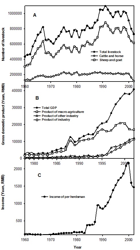
Fig. 2. Y. Peng, et al.

Fig. 3. Y. Peng, et al.
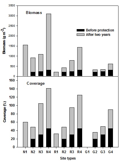
Fig. 4. Y. Peng, et al.
Table 1
Area (km2) of desertification and human population levels for four landforms in Zhenglan Banner, Hunshandak Sandland. Percentage of total area is given in brackets.
|
Landform |
Desertification area |
Severe desertification area |
Population in severe desertification area |
|
Sparse elm forest |
4582 (45%) |
2138 (21%) |
4121 |
|
Low grassland |
3258 (32%) |
1629 (16%) |
2237 |
|
Hills |
1222 (12%) |
407 (4%) |
3526 |
|
Wetland |
1018 (10%) |
305 (3%) |
623 |
|
Total |
10080 (99%) |
4480 (44%) |
10507 (13%) |
Table 2
Population demand for present and planned industrial items in Zhenglan Banner
| Itemsa | 2002 | 2005 | 2010 |
| Ecotourism | 5600 | 10600 | 23000 |
| Dairy and meat industry | 2400 | 5200 | 15600 |
| Power plant | 200 | 420 | 620 |
| Fur, leather, textile industry | 1600 | 2400 | 6500 |
| City construction b | 220 | 2120 | 5500 |
| Total | 10020 | 20740 | 51220 |
a Other forecasted data according to corresponding item plans and the long-term development plan of Zhenglan Banner (Zhenglan Banner Government 2000).
b Forecast according to city planning of Shangduyin Gol in Zhenglan Banner.
Table 3
Predicted area (km2) of increased restored grassland with the percentage of people living in cities or towns at 45%, 55%, 65% and 75%.
|
Rate of urbanization |
45% |
55% |
65% |
75% |
|
Predicted areas of restored grassland |
4480 |
7942 |
6618 |
7637 |
|
Rate of restored land as a percentage of total grassland |
44% |
78% |
88% |
92% |
|
Rate of urbanization area as a percentage of total area |
0.1% |
0.14% |
0.16% |
0.18% |